
[This walk was completed on the 30th August 2022]
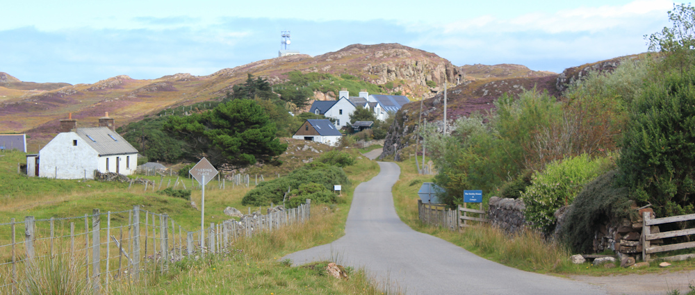
Back at the turn-off to the Stoer lighthouse, I stash my Scooty bike behind the village hall, chain it up and return to the road. No lighthouse today, instead I’m sticking to the main road and heading northwards. Time to get going.
It is a beautiful day. Barely any breeze and with just a few fluffy clouds crossing the blue sky. The temperature is set to reach the dizzy height of 17 degrees, and this wise old sheep has decided to shelter in the shade of a cement mixer.

I’m leaving Stoer behind. On my left, two great diggers sit perched against the rockface like grazing dinosaurs. It’s a Tuesday, approaching midday, but there is no sign of life in this little quarry.

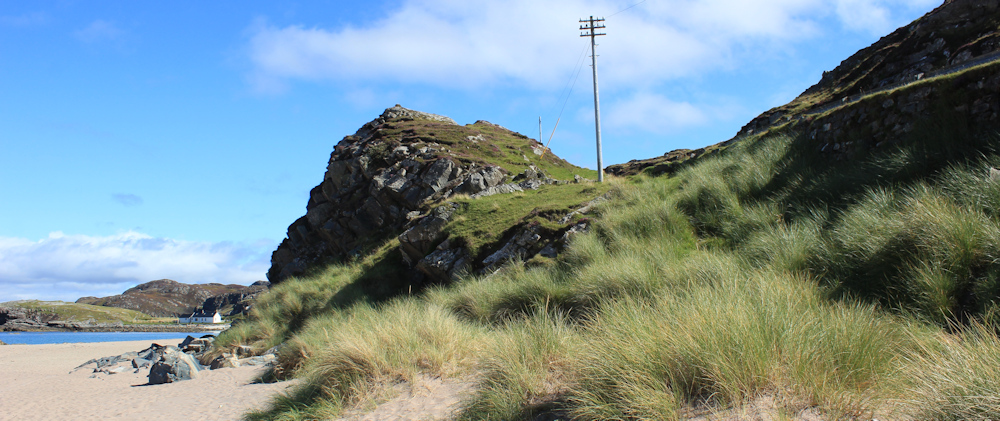
I reach the top of a rise, and the landscape opens up ahead. Two motorbikes come roaring past – a reminder I’m back on the Wee Mad Road, and back on the infamous NC500 route.

Luckily traffic is very light. After a mile or so of pleasant walking, I realise I’m approaching a place called Clashnessie. The road begins to descend, and there’s the sea ahead!

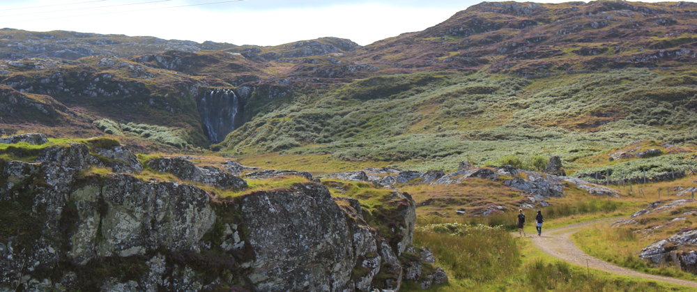
A faded footpath sign to my right looks intriguing. “Route to Falls.” It points down a track where a couple are walking and, yes, there is a large waterfall in the distance. Eas Clais an Easaidh, says my map.
I stop to take some photographs of the falls, but unfortunately my lens is pointing into the sun, and the resulting photos are disappointing.
Onwards, down the road.
I drove along here earlier, and then cycled back to Stoer, so this is the third time I’ve been along this road and, therefore, what comes next isn’t really a surprise. But, it is still astonishingly beautiful and takes my breath away. The road drops down to sea level and ahead, beyond a bright green field, is an amazing stretch of wide sands.
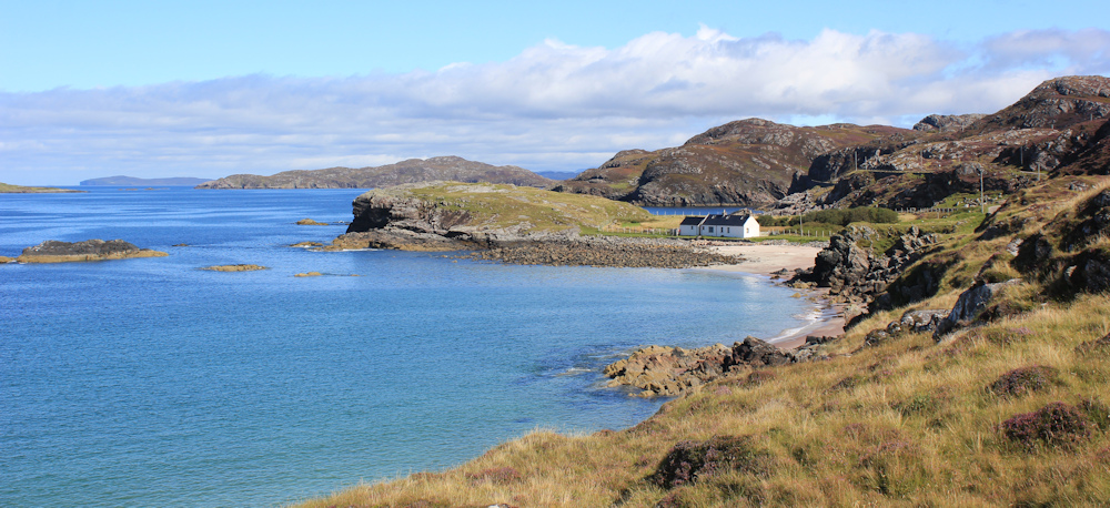
This is Clashnessie Beach. A total suprise to me when I first saw it – and an unexpected delight.
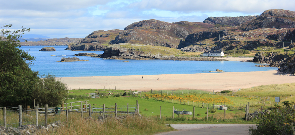
Clashnessie itself is a group of houses, with a telephone box and little else. But the main attraction is the beach, sitting protected within a wide bay and surrounded by wild scenery.

I leave the road and follow a path down to the sands. Walk along and sit on some rocks overlooking the bay. Shrug off my back pack, and spread out my lunch. What a perfect spot for a picnic!
Afterwards, I balance my camera on the rocks and set the timer. Run down the beach and turn around – just in time to snap a near-perfect self-portrait.
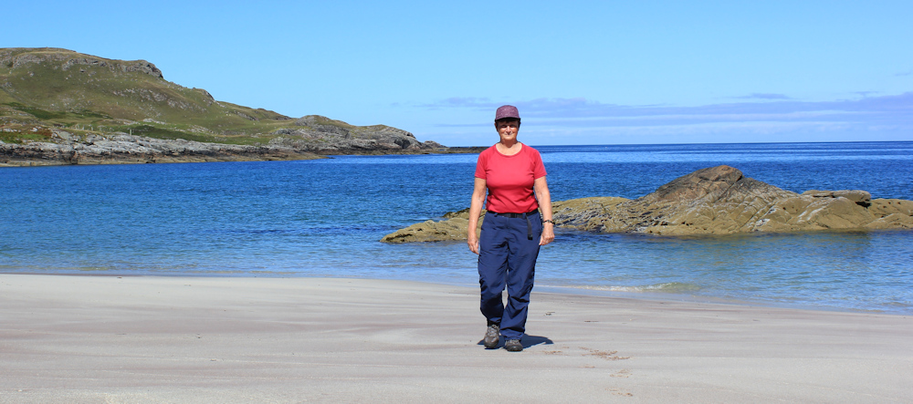
It’s a shame to pack up and get going, but I’ve barely started my walk and have no excuse to stay here any longer. I shrug my rucksack back onto my shoulders and clamber up the slope at the end of the beach, where a vague path takes me up to the road.
The road climbs higher, hugging the curves of the cliffs above the shore, and I keep stopping to take photographs of the beach below me. A family had arrived just before I finished my lunch, and seem to be spreading out a picnic of their own. A few dog walkers have appeared.

I left just in time. The beach is now positively crowded!
Looking ahead, I spot this idyllic little cottage with its own private beach – although maybe at low tide the sand here connects with the main beach. I assume it’s a holiday cottage, because it looks deserted.
The Wee Mad Road is living up to its name. High above the sea, with a steep drop on one side and uncompromising cliffs on the other, it is narrow and winding with a series of blind bends. When I drove along here earlier, I was really concerned about meeting uncoming traffic and of being forced to reverse around one of these tricky bends… and already I’m feeling uncomfortable about the drive back.

I distract myself by looking down at the rocky shore beneath me. The water is remarkably clear – and I stop to take more photographs. You can make out every rock below the surface. Beautiful.
I’ve got past one series of bends, and now the road runs straight for a few hundred yards. The bend ahead – another terrifying leap of faith when driving, as you can’t see round the corner – marks the end of the coastal stretch.

For the next few miles I’m heading inland, past a loch (Loch na Bruthaich) and then up the river valley.

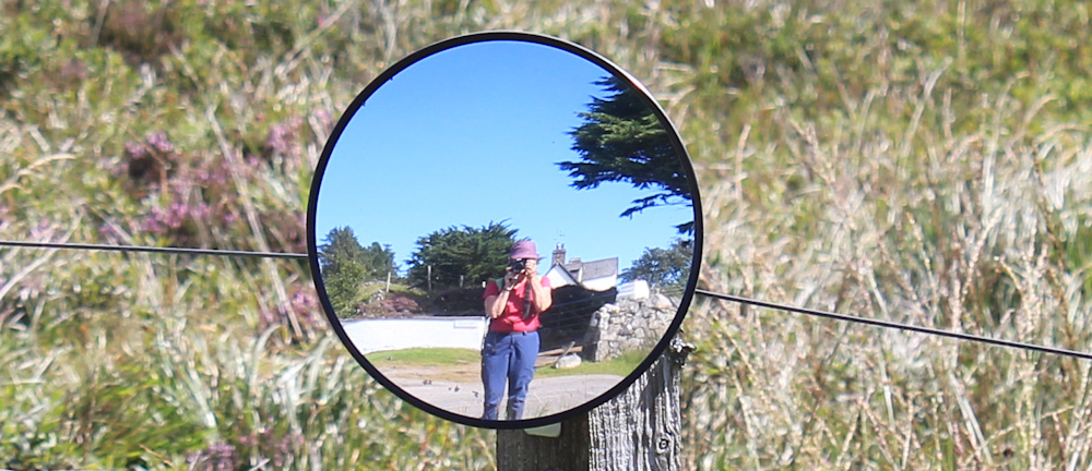
After a mile or so, I reach a place called Strathcroy. Just a single house with a tiny convex mirror opposite its drive – possibly the smallest traffic mirror I’ve ever seen! I can’t resist a self-portrait, of course.
Onwards, past Strathcroy, past another remote cottage, and now I’m walking beside another loch. Lochan Fearna. I may not be next to the sea anymore, but there is still plenty of water around me.

Past this small lochan, I reach another and much larger loch. Loch Eileanach. A sign says Lagg Fishery, but I see no evidence of a fish farm, and nobody seems to be fishing from the shore.
Nearby, I spot a man with his dog, walking down a rough field. What are those strange boxes? I take a photograph on zoom, but can’t make out what they are. Beehives?

Here’s another box, with free range eggs for sale. I don’t stop to look, because I don’t need any eggs. “Lagg Eggs” says the sign, which at first I mistake for Large Eggs. Lagg must be the name of the area.

I look on my map, but don’t spot anywhere called Lagg and the name isn’t mentioned.
This loch is beautiful. The mountains which have been peeking over the high ridges for some time, now rise up into an impressive range. Wow.

The loch is dotted with waterlillies. The lily pads are bright against the deep blue of the water, but the flowers are past their best.

Leaving the loch behind, the road dips downhill again and – oh, good news – I can see the sea ahead.

But, just when I think I’m going to be able to walk along the coast again, the road veers inland in an S shape, navigating around a marshy area, and heading for a river.

I pass a sign saying “Assynt Hydro”, cross the river, and head towards a place called Oldany, which seems to consist of a farm and a cluster of buildings. Before it reaches Oldany, the road changes its mind, and crosses back over the river again.
I’m growing tired, and stop to sit on the wall beside the river. Wish I’d brought more food with me… hang on… I remember my emergency supply and pull out a trio of Werther’s Original toffees.
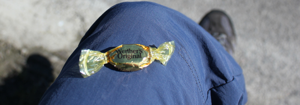
Suck my toffee slowly, trying to make it last longer by resisting the urge to crunch down on the final slither – but fail dismally. Eat the second one. Decide to save the third one for a real emergency.
Suddenly, I get the feeling I’m being watched. Look up, and see a cheeky sheep looking at me from the other side of the road. Perhaps it wants a toffee too?

Well, I’m not sharing my last sweet with a silly sheep! I pop the final toffee back into my pocket and set off again.
To be continued…
Route so far today:


I stayed at Drumbeg when searching for tidal islands when I wrote No Boat Required. Its’ a beautiful place.
There’s a track off the road that goes to the shore opposite Oldany Island.
I’d been told that it was tidal (which maps imply) but it wasn’t dry or safe to wade across.
I was later told in the Drumbeg Hotel that you can only walk across about twice a year so it didn’t meet my definition for inclusion in the book. I’ve written about it as one of the many ‘nearly tidal islands’.
It really is beautiful. I noticed that track. What a shame you couldn’t get across to the island.
Ah yes I remember that lovely beach. I parked beside it for the circular walk I did. It was so dark when I got back I opted to walk on the beach and wade through the stream at one side than go round on the road, which turned out to be deeper than I thought so I got the bottom of my jeans wet, then covered in sand. That ended up getting a load of sand in the wardrobe of the hotel I was staying at when I hung them there to dry. By the time I got to the other side of the beach it was so dark, with no street lights I couldn’t even see the car until I pressed the key fob to make the lights flash. Happy memories though, it was a really lovely walk even if I ended up doing the last mile or two in the dark.
Part of the reason it was dark was I underestimated just how long it took to drive on that road. Despite being a B-road as you found it’s not exactly built for making quick progress!
It is one of the most beautiful beaches I think I’ve come across, Jon. Must make a list of the most amazing beaches. And you’re right about the B road being slow. And pretty terrifying to drive along in a van too.
Some beautiful scenery on this walk Ruth. Clashnessie beach looks gorgeous, especially in your header photo, and I love the location of that little white cottage by the sea 🙂
I wanted to live there Eunice, but I think it would be a bit lonely, especially in the winter.
Absolutely beautiful photos Ruth. Hope to get there some day!
Thank you Robin. And really worth taking a tour of the northwest of Scotland. It’s an amazing place.
Ha ha – we put up the ‘smallest traffic mirror in the world’! I didn’t read the small print when I ordered it from Amazon but it helps a bit as it is tricky pulling out of our drive when folk are going too fast on the straight road up. Glad you enjoyed your walk, it is a lovely part of the country.
😆 Thank you for commenting and I’d forgotten all about that tiny mirror until you reminded me. Getting the size confused is easily done on Amazon! I very much enjoyed this walk and, yes, you live in a truly beautiful area.