
[This walk was completed on the 1st September 2022]
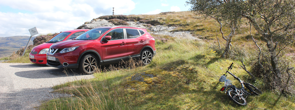
I leave my bike hidden in a ditch at the top of the hill. The two red cars I saw yesterday are still there and I assume the walkers must be wild camping somewhere in the wilderness. On closer inspection, the cars look a little dilapidated. Have they been abandoned? It’s a mystery.
I turn my attention to the road ahead of me. And what a beautiful road it is too. Such a huge, open landscape. And the sun is shining again. A perfect day!

Further down the road, I get a wonderful view over the sea loch – Loch a Chairn Bhain. Below, on the shore, is a large white house set in green lawns. What a place to live!

There is a track leading down to the house, but I’m sticking to the road.
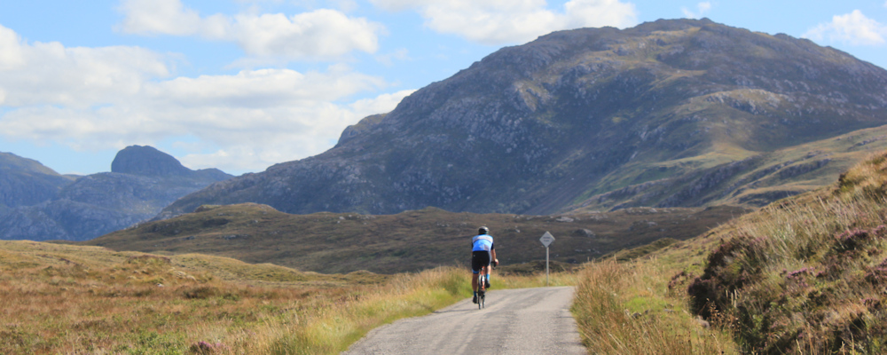
This is my last day of walking along the B869, the infamous Wee Mad Road, and it is certainly living up to its name. Winds high above the loch, with blind corners and few passing spaces.

But the views are fabulous. A white yacht is gliding slowly along the blue waters of the loch. On the other side there seems to be nothing but remote wilderness. So empty. So peaceful.
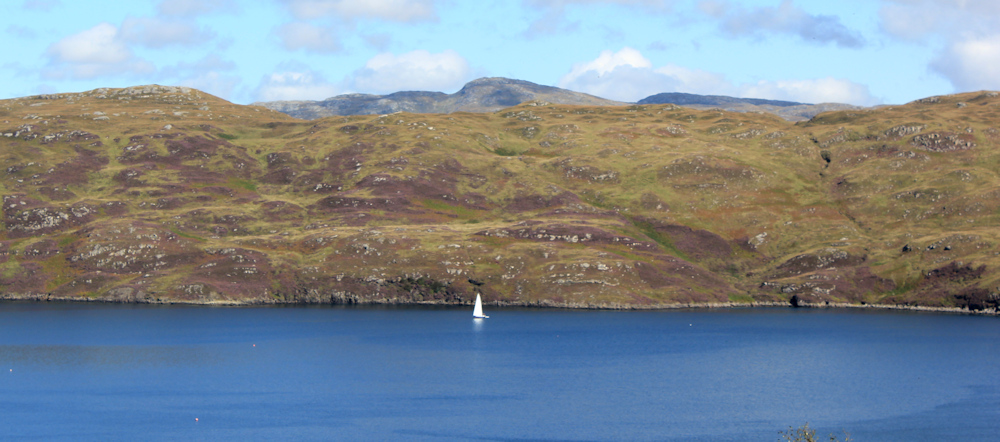
I keep stopping to take photographs of the great view down the loch. Somewhere, at the far end, the loch empties into the open sea, but that is currently hidden by the natural curve of the inlet. And here is a different view of that lovely white house,

I reach a sign that warns me of another punishing 25 percent slope. A one in four gradiant – which means for every four metres you travel along the road, you rise (or fall) by another metre. Luckily, I’m going downhill.
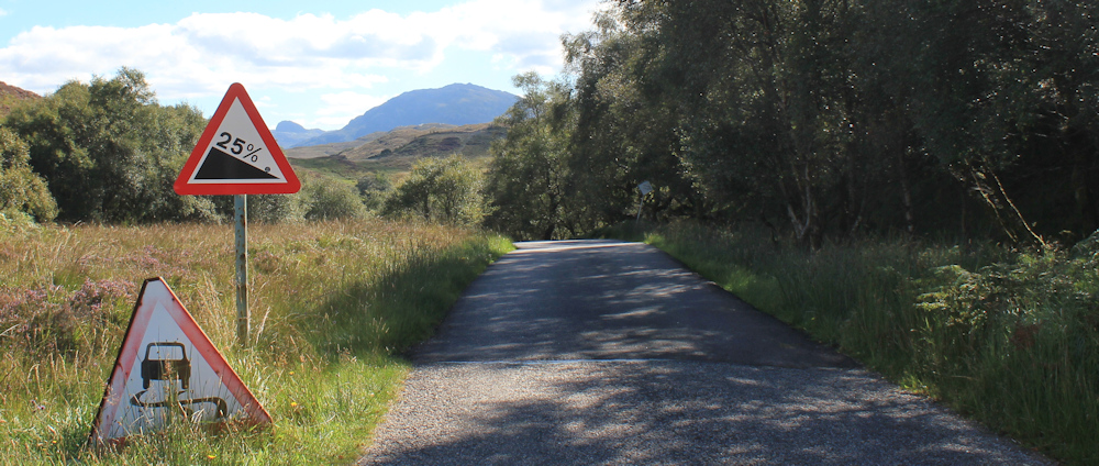
(I drove along this road earlier in my van, and then cycled back to the start of my walk. I remember this steep hill. I’m proud to say I managed to cycle up here on my electric Scooty bike without having to get off, and managed to overtake another couple of cyclists who did have to dismount.)
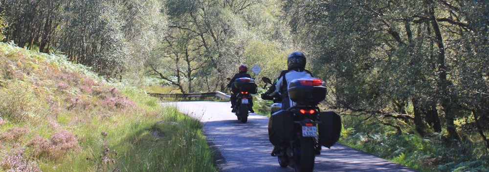
Hear the noise of motorbikes behind me, and step off the tarmac onto the grass verge to let them go past. They trundle carefully down to the next bend.
I’m lower now, but still walking high above the waters of the loch. My view is obscured by a veil of trees, but it is nice to be walking among vegetation – a refreshing change after the vast open spaces above. The trees are mainly silver birch, or course – the brave “pioneer” trees that are the first to colonise difficult areas.

Through gaps in the trees, I get a view up to the top of the loch. There is a bridge up there, almost obscured by the brightness of the sunshine. Meanwhile, a cloud has dimmed the light over the loch. I take a photograph of the view, which includes a huge fish farm.

I pass the sign to a salmon farm. The road climbs higher again, and the clouds clear, so I get a better view of the fish farm below. Take more photos of the loch.

In a lay by ahead is a camper van. At first I think the owner has parked to admire the view, but as I get closer, I really it is a semi-permanent encampment. The van looks as if it is going nowhere fast, and the owner doesn’t appear to be home
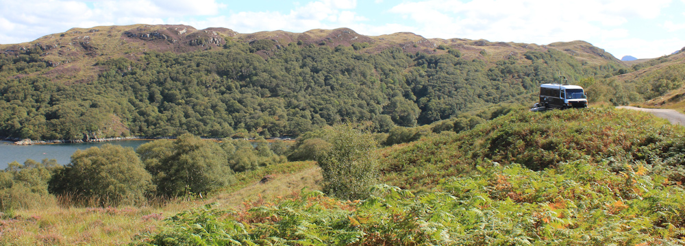
The road drops down and runs along the side of a tree-lined gully, with a steep drop below. Luckily, traffic is very light. But several vans pass me at this point, including a bright yellow VW camper van – which makes me smile because of its cheerfullness – and later a delivery van.
I’m now at the bottom of the narrow valley, where the road runs next to a stream. It’s very peaceful, with birds singing in the trees and the natural rushing of the water as it tumbles over stones on its way down to the loch.
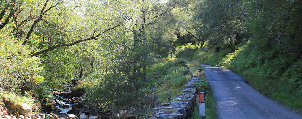
The trouble with rushing water is that it sounds very much like oncoming traffic, so I have to keep turning round to check there is nothing coming up behind me.
I’m quite pleased to cross over a bridge and begin the climb out of the valley. Open countryside again. The road twists and turns, heading uphill.

Out of the trees, I can get a sense of where I am. What has happened to the mountain range and the hump of Sail Ghorm – my constant companions over the past couple of days? It’s weird. I haven’t walked very far, but that particular mountain seems to have completely disappeared!
I take photos of the new mountains on my right, but photography is difficult because my camera is facing directly into the sun
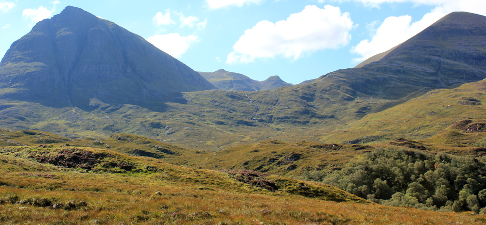
You can see there is a wonderful little stream gushing down the pass between the two peaks. It has resulted in a succession of waterfalls, which I’ve photographed on my way up from the valley – but none of those photos turned out well either.
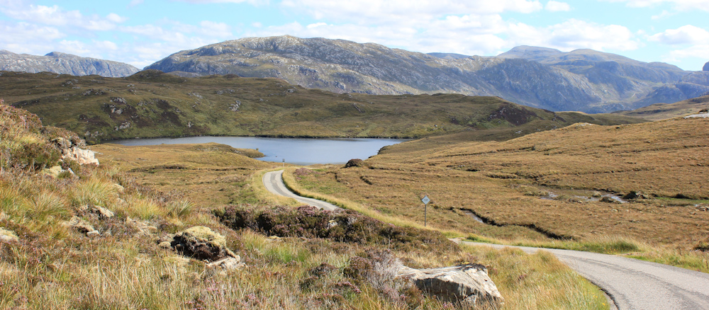
Never mind. I concentrate on the road ahead. It’s dropping again, down towards another pretty little loch.
I look for a convenient rock to sit on. It’s nearly 2pm and time to stop for a rest and a snack. It’s also time to check my map and work out where I am – and what on earth has happened to Sail Ghorm. Ah, here’s a good seat.

With the help of my map, and my Garmin, I realise those two peaks in the photographs above are, actually, all part of the range called Quinag. I think the larger peak to the right is actually Sail Ghorm. It looks very different from this side!
Refreshed by a drink and some food, I shrug my rucksack on my shoulders again, and set off along the road. A whirring sound behind me alerts me to a lone cyclist. I snap a photo of his disappearing back.
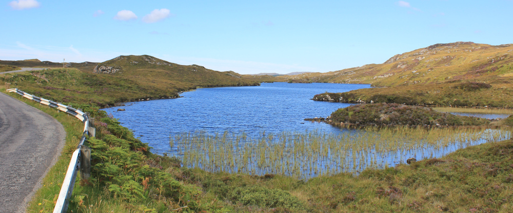
I’ve reached the shore of the pretty loch. Loch Unapool. (Not to be confused with Ullapool!)
Beyond the loch, the road descends in a series of easy curves. Then, around a bend, I spot a junction ahead and a mass of road signs.

This is where the little B869 (aka the Wee Mad Road) joins the A894. An important milestone, for me, it seems. Only 11 miles to Scourie, and 36 miles to Durness – by road, anyway. I’m making progress!
I’m sad to be leaving the Wee Mad Road behind. It has been a beautiful route. Easy walking on tarmac but never dull, and pssing through fantastic scenery. So I feel that familiar tug of sadness as I turn away from a familiar friend.
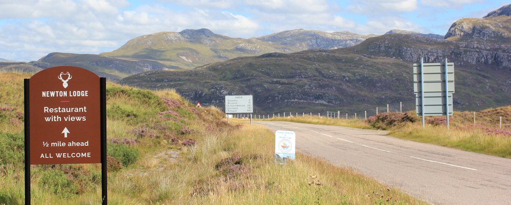
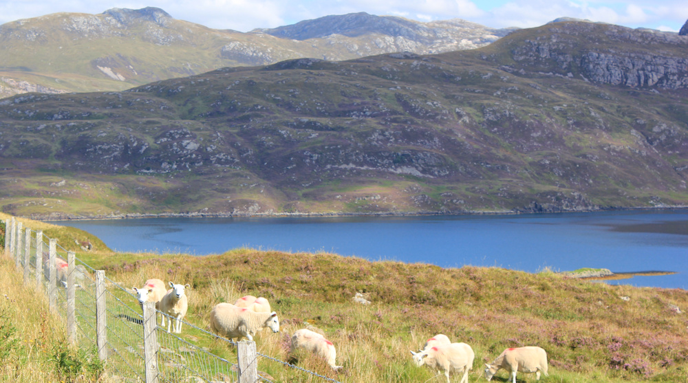
So many signs litter this junction! I’m pleased to see the sign for Newton Lodge (more on this later). Another sign says beware of sheep… ah, here are the sheep, safe behind a fence by the shore of this loch. A new loch. Loch Glencoul
The A894 is relatively busy, but it is also wide and with an easy grass verge for walking. Only a mile to go to the parking spot where I’ve left my van. Ah… there it is.

On the way, I pass the driveway to Newton Lodge. After 4 days in a campsite, I’ve booked myself into here for one night. Fluffy white towels, a private shower, and a bed I don’t have to make myself… I’m looking forward to it.

When I reach the parking spot where I left my van, I stop to read the notice board. It points out a feature in the hillside on the other side of Loch Glencoul. This is a place where a young section of rock – quartzite, which is formed from sea sand – was pushed up between layers of older rock, creating a sandwich effect.

The old rock is 3,000 million years old. The younger rock is a measly 540 million years old – a veritable baby in geological terms.
I look across the loch and the sandwich layer is easy to spot. Take a photo. Try to imagine the immense geological forces that would have caused this to happen…

… we are so insignificant in the universe. The timescales – and the forces involved – are almost beyond my comprehension.
Well, I have mundane things to think about now. I must drive this van back along the Wee Mad Road to collect my Scooty bike. Then, once more brave the Wee Mad Road – for the very last time – to return to Newton Lodge for the night. Then, tomorrow, I’m moving on to my next campsite – in Scourie!
You can read about driving the Wee Mad Road on the Travelling Savage site and an account of cycling the road on the Highland Transfers site. Of course, in my opinion, the best way to travel this road is to WALK it!
Miles walked today = only a pathetic 4 miles (good grief!)
Total around coast = 4,857 miles
Route:


Hi Ruth, ah yes the Glencoul Thrust! I remember as a young Undergraduate Geologist visiting this area back in 1974. We walked along the shoreline of Loch Glencoul, to examine the exposure close up. It was in February and it was blowing a ‘hooley’. It was the only time I had a bad case of windburn! Of course, there was no bridge back then and we crossed the Unapool ferry a few times during our field trip. I had been back to this area a number of times to climb Munro’s and Corbetts, including the three highest tops of Quinaig. The last time I passed by Quinaig was during my walk in 2019.
It may only be four miles but it’s still progress. More beautiful scenery, I love the view over Loch Unapool, it looks very pretty, also the view after the sheep 🙂
every one needs a wee mad road in their neck of the woods, their realm (better yet, cloned road signs with :Wee Mad Road Ahead”). Thanks for sharing your adventures.
When I walked the Cape Wrath Trail last year, my route went over that sandwiched ledge of newer rock in Loch Glencoul, so it’s nice to see a photo of it from the side.
Fantastic stretch you have just walked these last few days (I know it was August/September last year) It’s years since I’ve been that far north – thanks for the memories.
I have a sad story about cars being left in odd places for days. When I walked past the Mull of Kintyre lighthouse i was puzzled why the car park by the lighthouse was checked out by the police at 06.30 every morning. I later discovered why. It was a precaution to check no one had left their car there overnight when out walking the day before, and had an accident. Sadly a German tourist had gone for a walk one day without telling his hotel where he was going. He had an accident and broke his leg. His body was found four days later. Apparently his wife was not best pleased that no one had gone searching for him over the intervening four days. It was mainly his fault, but as a precaution the police started checking the Mull early each morning, before any tourists arrived for the new day. Moral – tell people where you are going and hope to return. The Kintyre Peninsular is very rough!!!
Rather a belated response, Chris, but that’s a terrible tale! Poor man.
More wonderful scenes and the ancient rock formation is amazing, and as you say, the time scales almost beyond comprehension. I think it does us good to be reminded of how insignificant we are in the great scheme of things.
I also meant to ask you if you saw Widemouth Bay on the Cornish coast when you were walking that part of the coast. The rock formations there are fascinating and also ancient, though not as old as the ones you saw here, being a mere 300 million years old.
Hi Karen and, yes, I remember the wonderful rock formations at Widemouth Bay. Was an opportunity to reread my blog post of the day – https://coastalwalker.co.uk/2013/11/21/134-crackington-haven-to-bude/
I went and had a reread of your post too and was amused to see I actually commented on the rock formations at the time! I didn’t remember it at all but maybe something was in my subconscious and that is why I wanted to go there when I was in Cornwall a few years ago.