
[This walk was completed on the 29th April, 2023]
Today, I am walking along the road towards Rhiconich, although I may not get as far as that if I get distracted by diversions! I chain my bike beside a gate on the Tarbet road, and join the main road towards Laxford Bridge. To my right is a pretty loch, Loch a Bhagh Ghainmhich.
[I think this means “sandy bay” in Gaelic, if you take some liberties with the spelling.]
After another cold night in the van, it is good to see the sun shining in a blue sky. The good weather has brought the traffic out too. I’m back on the NC500 route, and encounter the usual parade of motorhomes and camper vans.
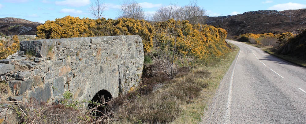
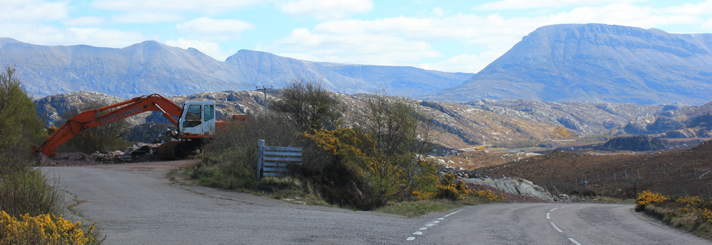
This must be a new road, because I come across signs of an older road running under, or parallel, to this route. For example, here are the remnants of an old stone bridge – now replaced by a featureless stretch of tarmac which hides a culvert underneath the road. That’s ‘progress’, I guess.
There is also a strange mix of wild countryside and minor industry. Here, just to the side of the road, is a quarry. Disused according to my map. But, although it is Saturday and nobody is around, there is an excavator on site, and it doesn’t look disused to me.

I walk past another beautiful loch. Loch na Claise Fearna. It even has an island in the middle of its bright blue water, and a fragrant edging of golden gorse.
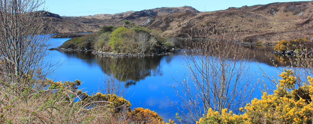
[Later, I discover that Claise Fearna means, somewhat unromanically, the older ditch or older drain.)
This is a lovely walk. Look at those mountains ahead. I feel I’m really heading into the far north of Scotland now.
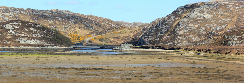
An unexected open space of water appears in front of me. I check my map. Ah, Loch Laxford, with its fish farm, and this is the same loch I admired yesterday from above Fanagmore. Loch Laxford is a sea loch – an estuary really – and I expect this will be about the closest I get to the coast on today’s walk.

The road swings eastwards to run around the edge of the loch, but the water is about 1/2 mile away and invisible at this point. I walk past another little quarry. Tall mountains ahead.
Walking into the morning sun makes photography difficult. I step off the main road to walk along the remnants of an old road, now with grass growing through a rough tarmac surface. The pointy mountain ahead – blue against the bright sky – is Ben Stack.

I think of my neighbour at the campsite (who has moved on to Durness). She cycled to the base of Ben Stack before climbing it. Quite a feat, but something she considered as just an everyday thing to do. I feel exhausted just thinking about it.
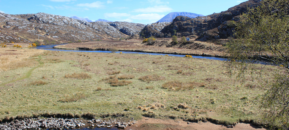
The landscape opens up on my left. This is a surprise. I look at my map, and see this area is marked as marshland and is really a bay on the edge of, and part of, Loch Laxford. Looks a bit dismal – full of mud and slime. I wonder if it fills with water when the tide is in?

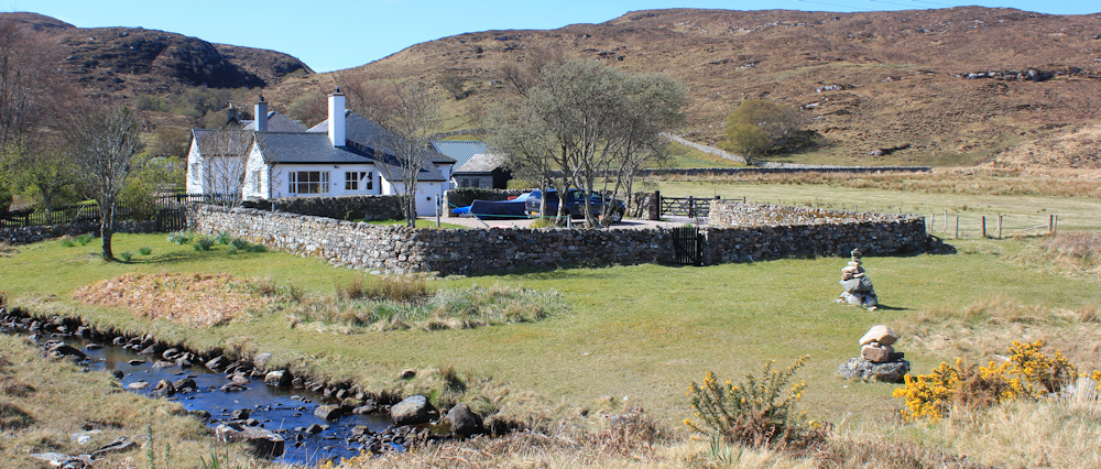
A side-turn to my right leads off to a place called Badnabay. I don’t go exploring, but stick to the main road. This wee house, with its walled and enlosed garden, looks strangely incongruent set in the wild landscape.
Across the empty expanse of marsh, I can see a road leading up the hill. Wonder where it goes? Check my map again, and realise with a shock that I am seeing the continuation of the main road on the opposite side of the loch – and I will be walking up that same hill later.
There is something really disheartening about realising that you are going to walk several miles just to end up not far from where you’re standing now!
I pass a sign that says “No parking, Reay Forest Estate.” Nearby are a couple of scrubby bushes and a few sad looking trees. That’s not a forest! But a bit further along, I do come to wooded area that is surrounded by a deer fence. And I hear my first cuckoo of the year.
The cuckoo cheers me up. Despite a cold night, and a chilly day even in the sunshine, spring is really here.
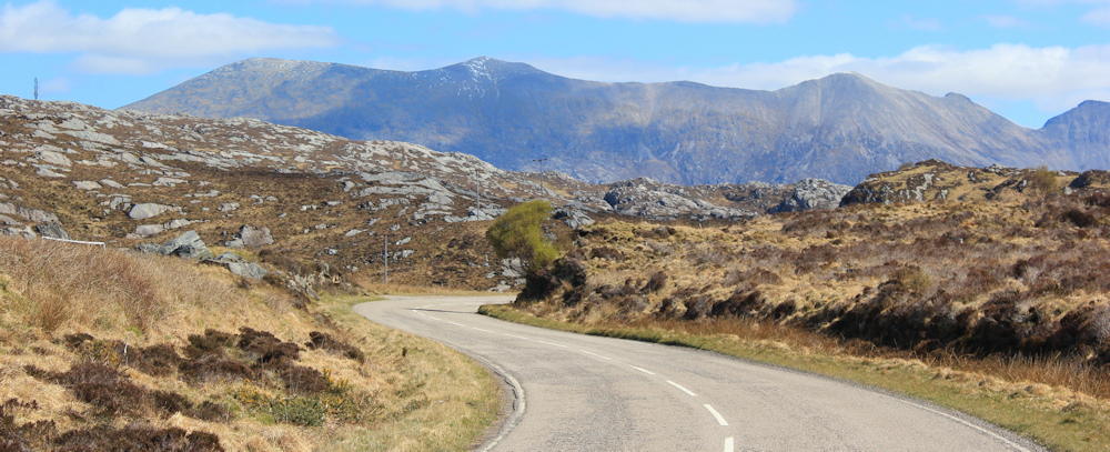
The road begins a long curve that will take me around the top of the loch to Laxford Bridge. Spring might be here, but the mountain ridge ahead appears to have snow on its peak.
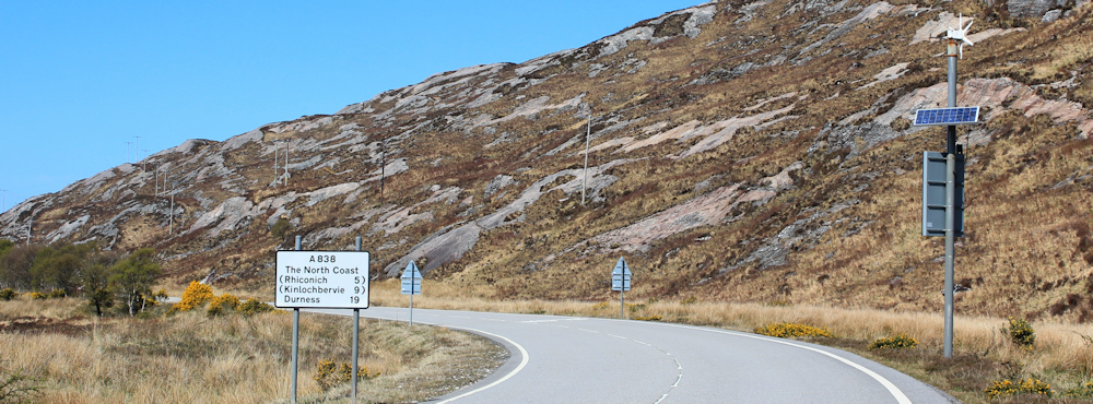
I pass a old sign – a ghost of its former self. “Visit the North Coast.” Yes, I’m on my way!

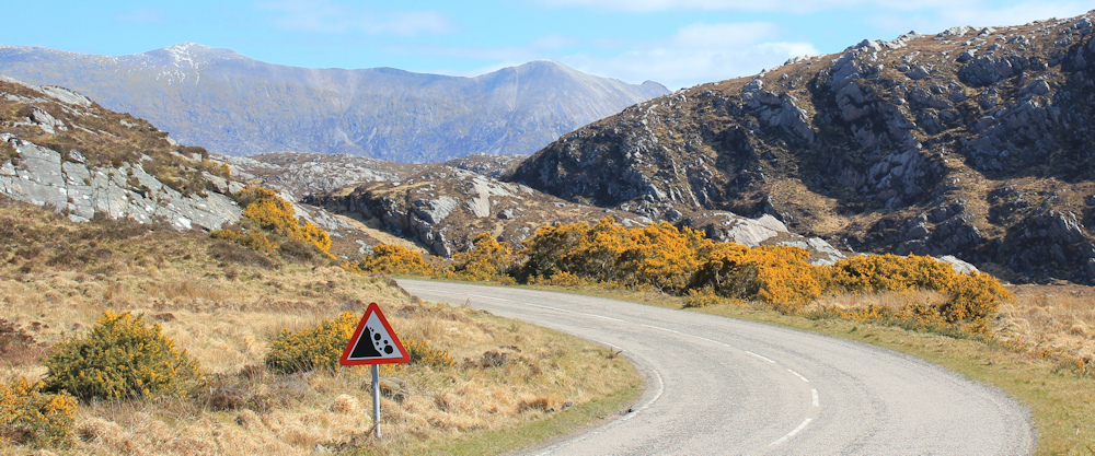
The curve seems never-ending. A sign warns of falling rocks, while those mountains definitely do have snow on the top.
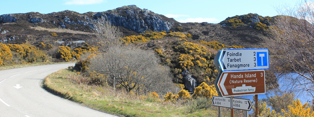
But, I’m nearly round the bend. Here is a sign warning me that I’m approaching Laxford Bridge, and I must reduce my speed now. Well, I really can’t go any slower without standing still!

Nearby, another sign tells me I’m on the NC500 (I knew that!) and only 119 miles from John O’Groats. Wow. John O’Groats is at the eastern end of the north coast of Scotland and I’m determined to make it there on this trip. 119 miles doesn’t sound far at all. Easy-peasy.

The junction with the Lairg road is busy. Cars, vans, motohomes, campers, motorbikes – all joining the NC500 at this point.
Laxford bridge itself is somewhat of a disappointment. The road narrows, as clearly this old bridge has not been replaced by a newer one. I have to queue with the traffic and wait my turn to cross.

Stop on the bridge to take photos. This view is looking up the river valley. My map shows footpaths on either side. You could walk up the river for 4-5 miles, cross over, and walk back down the other side. Tempting…
… but I must stay focused. It’s only 119 miles to John O’Groats, but who knows how long I’ll take to get there – my distances are so short these days!
I take a photo of the view on the other side of the bridge, where the waters of the River Laxford tumble untidily over a set of rocks, before pooling between tree-lined banks.

There is a car waiting for me to clear the bridge. Time to move on.
On the other side is a largish house and a small cottage. That’s it. Laxford Bridge, like many Scottish places, turns out to be almost exactly what its place name implies. It’s a bridge.
A trio of motorcyclists hurtle towards me and brake suddenly, surprised by the sudden narrowing of the road into a single track crossing. I wonder how many bikes and vehicles have ended up in the river at this point? The warning sign on the other side of the road is illuminated by a combination of solar panels and a little wind turbine. Designed to work under all weather conditions, except maybe on a dull, still day!
Only 5 miles to Rhiconich. Onwards.
A car draws up beside me. I expect they will ask me the way to somewhere I’ve never heard of. The map sticking out the back of my rucksack should be a sign that I’m in need of directions myself, but people often assume it means I’m actually carrying the map’s knowledge inside my head by some sort of magical transference. But, the lady who winds down her window isn’t asking me the way. She asks me if I need a lift.
How kind. No, thank you. I’m OK. I’m just walking.
Love this sweet little hut on the other side of the river. Probably a fishing shack. Wonder if it belongs to the big house I passed earlier?

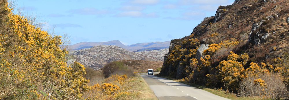
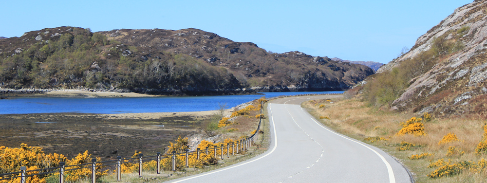
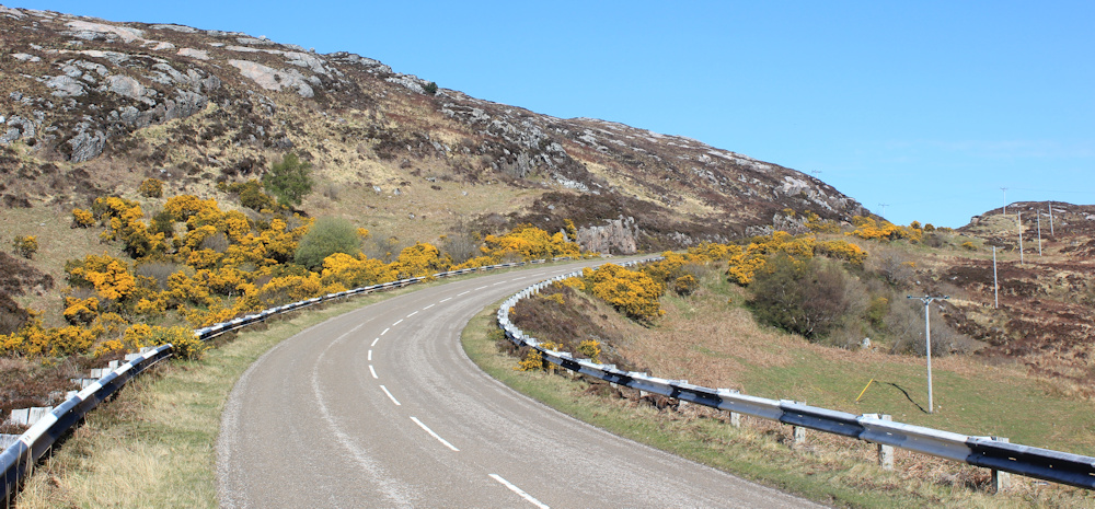
The road is sandwiched between the river and a mass of rocky hills. The gorse smells delicious. But the steady flow of vehicles is annoying. I wait for a break in the traffic to take this photo.
As the road begins to curve away from the river, I spot a boathouse and an old wharf. Looks like a good spot for a break and a late lunch.

There is a car parked near the boathouse in a little layby. I hear voices above me somewhere- two people having a conversation and intermittently calling to a dog, or maybe calling to a wayward child. I look forward to a conversation, but I never do see the owners of the voices. Sound carries a long way in this open enviornment. They might be up on the hill, or further down the river.
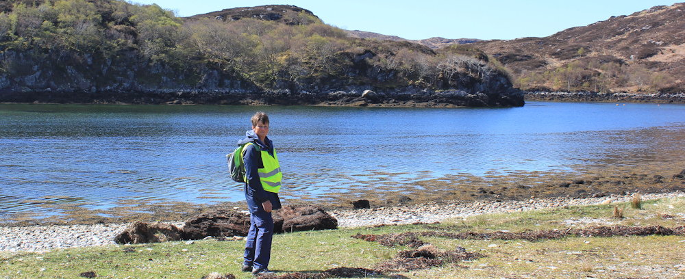
I eat my lunch and then pose for a self-portrait.
Back on the road, I notice these geometric parallel lines etched into the rocks. Why are they there? Is it an artifact from the drilling mechanism when they cut into the cliff to make this road? How do you shift tons of solid rock anyway?

The road curves upwards. I realise this is the section I saw from across the other side of the estuary – the road that looked so near, but was actually quite a long way round via the bridge.
I’m growing tired by the time I get to the top, and its a relief when the road flattens out.
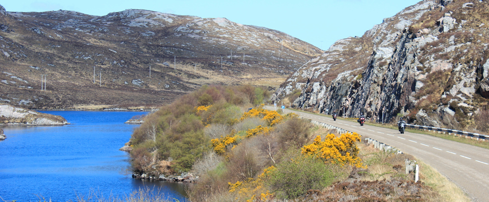
Motorbikes roar past me. What a lovely loch – Loch na Fiacail. [In Gaelic, this seems to translate as the Loch of the Tooth. I might be wrong!]
I’m getting tired, and pleased when I spot my car in the little car park – that colour blue is unmistakable. No, hang on. I haven’t brought my car with me, I’ve brought my camper van! Oh dear, still some way to go.

Carry on, past the rest of Loch na Fiacail – its a long loch – and then up another climb. Over the brow of the hill, a wonderful view opens up. Cyclists whiz past me, glad to freewheel after the climb. There’s another loch ahead – and that really is my camper van in the next parking place.

I’m not planning on walking all the way to Rhiconich today. It might only be a few miles up the road, but there are a couple of diversions I want to do along the way. Time to drive back to Scourie and spend my last night in the campsite there.
Miles walked today = 6 miles
Total around Coast = 4,886.5 miles
Route:


Hi Ruth, you are right about the vertical lines on roadside rock being from drilling. They used dynamite down bore holes to break and move the rock.
Love reading your descriptions of walks. Many I want to copy. Some I’ve done.
Thanking you, Mhairi
Thank you for confirming. And thank you for your kind words about my blog.
Yes I was a bit surprised by Laxford Bridge too, as you say just a bridge and a house but what surprised me is how far away it is signed on road signs. I think more than 50 miles, which makes you think it’s going to be far bigger than it is, really just a very minor road junction!
Looks like you had lovely weather for this one, it doesn’t get much better than that with clear blue skies and lots of sunshine.
Yes, I expected much more at Laxford Bridge. It was a busy little junction though.
More good weather and great scenery, I love the view where you got a break in the traffic 🙂
it’s no hardship walking along these roads when the traffic is light, and the sun is shining.
Lovely to read of that walk Ruth.
Some years ago I took a group on holiday to stay in that wooden-clad house at Laxford Bridge – virtually the only dwelling. A wonderful spot. And I really loved the walk up the Laxford River….it’s a wonderful area with lots to explore. I guess you’ll soon be walking by the Oldshoremore beaches….and Sandwood Bay too?
Thank you again. Paul
I bet they had a wonderful holiday. Such incredible scenery.
We drove from Thurso to Ullapool on June 1 and it’s interesting to see your photos. It’s so difficult to find places to pull over and admire the view and take photos, though I took plenty. I often wondered how you would get on with the really narrow roads with the passing spots but realized you just had to step onto the grass. We were lucky to have no rain for our three weeks in the UK.
You get a much better chance to admire the views when you’re on foot. There were surprisingly few places to park along that road. Glad you had good weather, and June was a beautiful month.
Impossibly blue water. Gorgeous. You’ve been so lucky with the weather. 🙂
It was a good day.
Hi Ruth – you are approaching the part of Scotland I spent most of my summer holidays at. Your ‘new’ road is not that new. It was done in probably the 1990’s. They broadened the road to take the big fish lorries from Kinlochbervie because back in the 1960’s – 1970’s it was all single track with passing places. Laxford Bridge may be small but just up the road towards Lairg is the main house for the Laxford Estate. This is a huge estate which includes the whole of the Laxford River system. It has for generations been owned by a very well known family – the Duke and Duchess of Westminster. Not sure who in that family owns it now but back in the 70’s it was Nancy Westminster (Duchess). The Laxford although privately owned is one of the best spate rivers in Scotland. So it is more important that you might think. In the old days when travelling up to Durness my Dad and I always stopped at Laxford Bridge to peer down and watch the salmon coming up the river. Happy memories. 50 years ago now!!! Back then there was almost no traffic on the road!!!
Hi Chris, thank you for all this information. Last time I was up here (last year) I took that Lairg road as my route back to Inverness. It seemed an important road on the map, and the SatNav told me to go that way. But most of it is still a single track road with passing places, and I remember thinking how beautiful it was. How wonderful to have seen salmon coming up the river. I didn’t think to look specifically, but I didn’t notice any.
Only go upriver to spawn, (males) or females to lay eggs in gravel, October, November, maybe December, Ruth. .Most die after.
Evening or early morning by a waterfall best time to watch for salmon leaping. 👍😊🦈
We drove from Durness to Ullapool on a damp, very misty, June day a few years ago, so your photos are showing the views we missed!
Your many posts bring back memories of an unforgettable road trip in the Far North.
This was a beautiful walk and a very enjoyable read. I do think it’s a shame that the romantic sounding Gaelic place names (Claise Fearna) translate to something so mundane. I hope you’ve had better weather in Scotland this summer that we’ve had in the south!