
[This walk was completed on the 6th May, 2023]
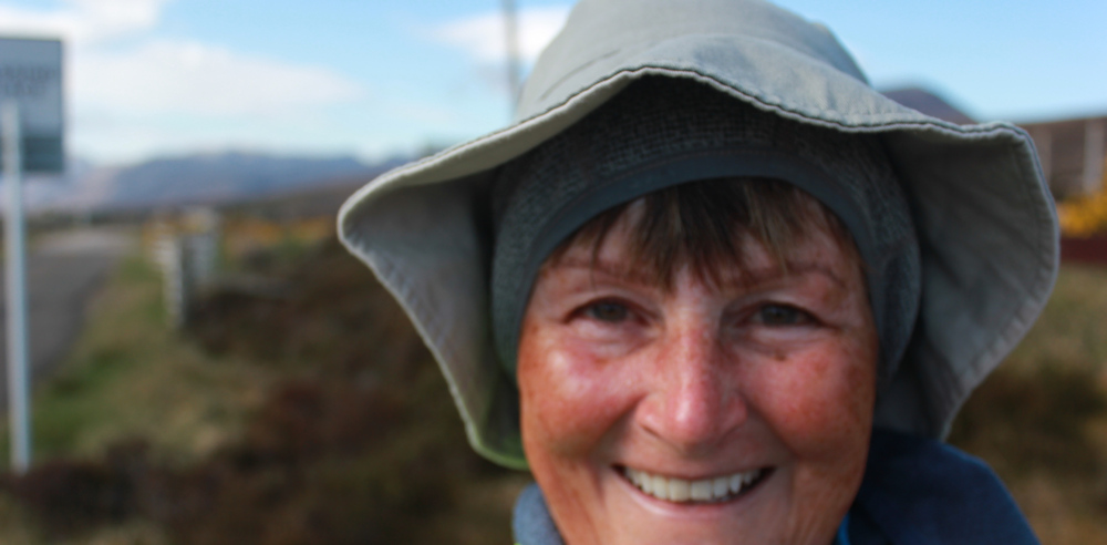
Today is Saturday, and it is Coronation Day for Charles III. (Although, perhaps not wise to mention this to anyone in Scotland!) Apparently it is raining in London – but, in Durness, I wake up to brilliant light and sunshine at 6am. How wonderful. I can wear my sun hat! But I keep my fleece hat on too, because it is cold.
There is a bus that runs from Durness heading east towards Thurso – but it only runs on a Saturday morning. Of course, I want to catch the bus, and leave my van and bike behind, even though it means I must walk this section of the coast backwards, so to speak.
I have a conversation with a very nice, but slightly confused, bus driver, who turns out to be an English woman who moved here after enjoying holidays in the area. She finds the midges troublesome, but luckily they aren’t out yet.
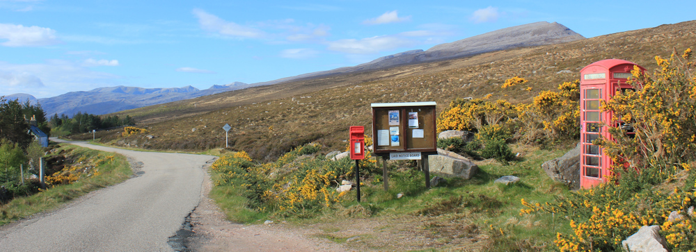
“It’s a telephone box in a place called Laid,” I explain. “It’s actually mentioned on your itinerary as a bus stop.”
Of course she has no clue where this place is. After much discussion between her and the only other passenger on the bus (a little old man with a timid dog under his seat), they decide it must be by the old school house.
In the end, the telephone box is obvious. Along with a post box and a notice board, this is what passes as the centre of Laid, I suppose.
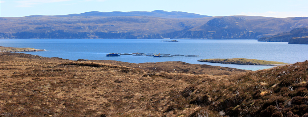
I’m walking northwards. Yes, I thought I was done with walking northwards, but I am walking backwards, so I should really be walking southwards. Everyone told me that the north coast of scotland would be straightforward after the ins and outs of the west coast – but they forgot to mention Loch Eriboll. Loch Eriboll sticks a 10 mile long finger into the coastline, and creates a 20 mile detour just to get around it.
Luckily, the views from the road are fabulous. Sadly, with the light in my eyes and the sun low on the horizon, my photographs are awful!

Laid is one of those non-places – just a loose collection of isolated cottages strung out along the road.

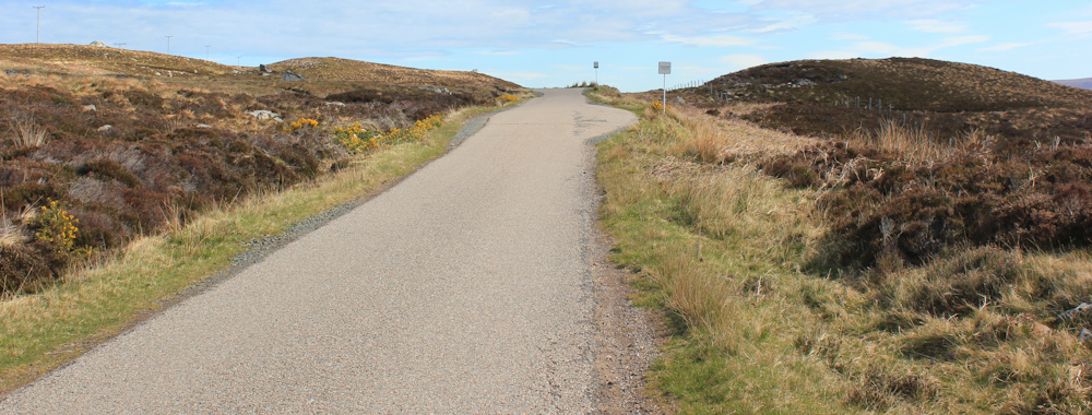
Now, I am entering a more remote area. The road climbs steadily. I really thought after a week of walking my fitness would have improved, but I feel tired already.
The views from the top of the rise are magnificent. Tomorrow, I will be walking up that shore on the other side of Loch Eriboll. I hope this lovely weather holds.
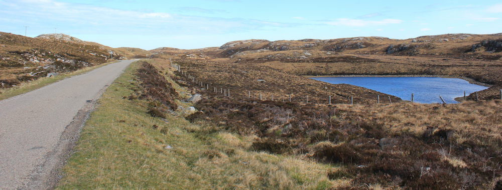
My map shows tracks further down by the water, but access seems to be private. There are fences in the way and it is not clear what state the actual ground is in. I decide to stick to the road.
It’s a bit of a boring road, as it veers away from the coast and the landscape is treeless and relatively featureless. Traffic is light, but a nuisance, with big vans and motorhomes roaring past and not enough room to pass me safely – so I have to keep jumping off the road. At least there are some pretty lochs to look at. This one has no name.
And, then, I crest another rise and… wow… what a view. The sea! I pick up pace down the hill, glad to be on the coast again.

Something whizzes past in front of me, but some distance away. Something big. An eagle?
Well, not really an eagle. It was actually a young person on the Golden Eagle zipline. As I get closer, I watch another victim being hoisted into place. I imagine it is very exciting, but it doesn’t appeal to me.
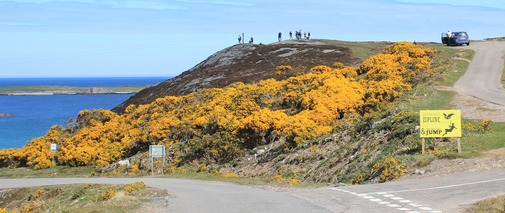
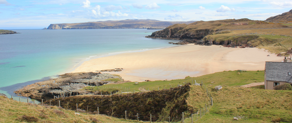
The zipline runs across a wonderful beach. Traigh Allt Chailgeag. I leave the road and cross a little river via some wobbly stones, to find a perch on some rocks. Time for lunch. What a great picnic spot.

[Later, I discover that Traigh Allt Chailgeag translates as the ‘Beach of the Burn of the Old Woman’, and is so named because an old woman fell into the little river and was carried into the sea and drowned. If I’d known that, perhaps I would have been more careful crossing the river!]
Sadly, the sun has disappeared, and I soon grow cold. Finish my lunch hastily. Time to move on.
The road on the other side of the beach is steep and winding. I stop to catch my breath, and to take photos looking back across the beach and the mouth of Loch Eriboll beyond.

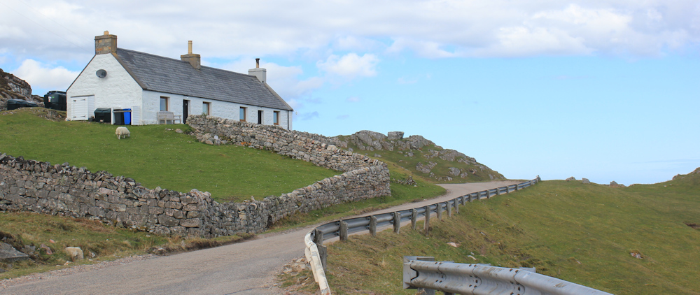
Near the top of the climb is a little cottage. I suspect it was once a crofter’s cottage, but it now looks like a holiday home.
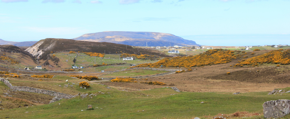
Over the hill, the view opens up. How gorgeous. That must be Durness in the distance, and the hills behind are on the Cape Wrath peninsula. They look so tantalising close… but I know the ferry isn’t running yet and they remain unreachable.
A sign by the side of the road catches my attention. “Ceannabeinne Township Trail.” Another one of those sad, abandoned places when the community was forced out to make way for sheep-farming. I am constantly stunned by this cruel phase of Scottish history.

I decide to take a look, and spend the next half hour following paths through a landscape of tumbled stone walls and the ruins of cottages. Signs explain the history of the place. Once this was a thriving crofting community…

..but the villages were forced out in the 1840’s. They didn’t give up without a fight, with first the women, and then the whole community, rallying together to beat back the baliffs and sheriffs. This incident was called the Durness Riots. The crofters gained a short period of reprieve, but eventually had to leave.
Out of this tragedy some good was born. The riots led to publicity across the country, and a young Advocate called Mr Napier was sent to investigate. He was very sympathetic towards the evicted villagers, and nobody was prosecuted for their part in their riots. Mr Napier, in later life, led the Napier Commision, which eventually secured rights for crofters through the Crofting Act of 1886. A real hero.

Back on the road, I have to leap onto the verge to give way to 3 high-powered sports cars that come roaring past. With some satisfaction, I watch as they are forced to back up and pull into a lay-by to give way to an oncoming car.
Driving cars at high speed along the NC500 is, apparently, a thing. People compete to see how quickly they can finish the 500 miles – a spectacularly stupid and dangerous thing to do. Much of the route is single track with winding roads and tight bends, sometimes on the ege of steep drops, passing through local communities, and shared by walkers, cyclists, horse-riders, children, tractors and local traffic.
Ironically, as I think these thoughts, I spot a road-side memorial with flowers tied to a fence. Although with no inscription or cards it is not clear what happened here, I suspect it was a fatal road accident of some sort.

The whole point of the NC500 is to enjoy the spectacular scenery of this beautiful part of the world! Best done at walking pace, of course, and certainly not at break-neck speed.
The road ahead climbs gently but steadily. There are more cottages here. I’m approaching the community of Sangobeg.

At the top of the hill I stop to admire the views. That is Sangobeg beach. Beautiful. I wish, now, I’d gone down to walk along the sands for a while
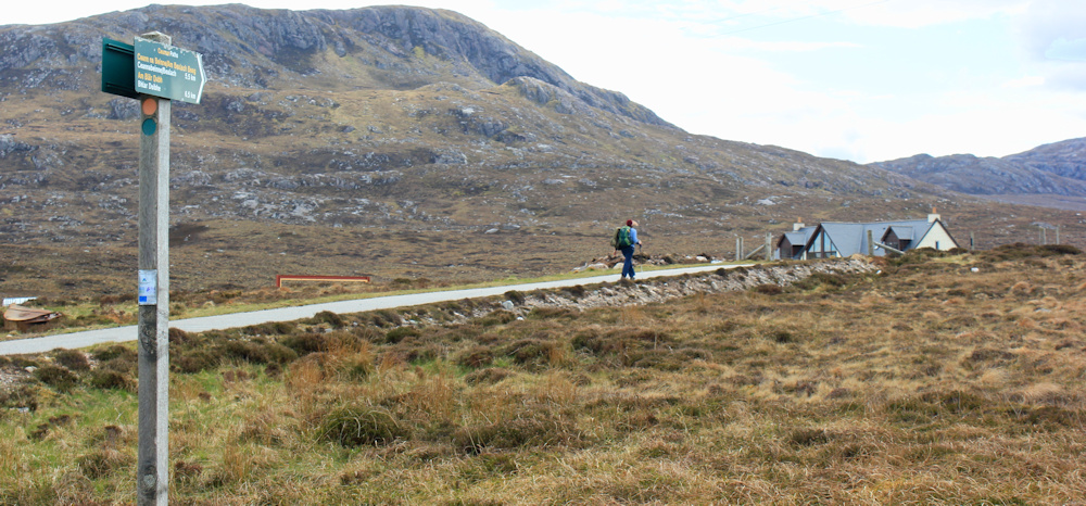
A core path leads off to my left, and a woman hiker is marching purposefully along it. I envy her – it’s all been road-walking today – but the path leads in the wrong direction for me.
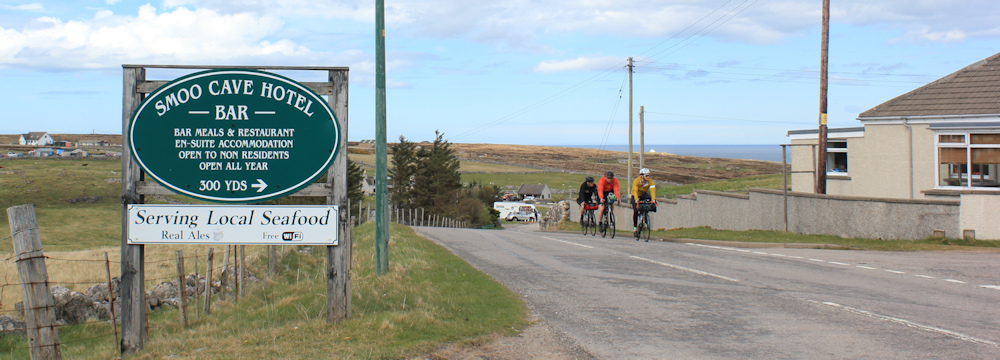
I reach a sign for the Smoo Cave Hotel. Only 300 yards down a side road. Tempting… but I’ve already had my lunch on the beach. Onwards.
I reach the Smoo Cave visitor centre. Now, I’d heard the name “Smoo Cave” mentioned on the campsite, but thought it was the name of a settlement. Now, I realise that Smoo Cave is an actual cave! Apparently it’s huge.

Unfortunately, you need to pay £10 to enter. Cheap enough, but they only accept cash and I am not carrying any cash. A kind woman realises my dilemma and offers to pay for me, but I am too embarrassed to accept. So, instead, I walk to a viewing platform on the cliffs above the cave.
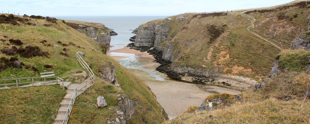
And this is as close as I get to the cave entrance. It does look impressive. Maybe I will return and do the trip another day. [Later, I learn that you can visit the first part of the cave free of charge, but I didn’t know that at the time.]

Back on the road, I pass a couple of snack bars. They are only selling cold drinks and ice cream at the moment, so I give them a miss. It’s too chilly for ice cream.

Close by, I pass Durness Village Hall, which has a garden. I turn off to have a look and am glad I did. It’s some sort of sculpture garden, with great slabs of stone engraved with various quotations.
“There are places I remember all my life.”
“All these places had their moments with lovers and friends.”
“In my life I’ve loved them all. John Lennon 1940-1980”
Hang on – John Lennon!?
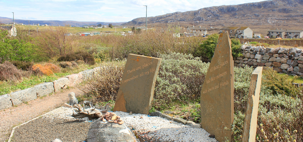
Turns out this is a John Lennon memorial garden. Why? In Durness? I have no idea. Confused, I spend some time walking around the lovely space, and then I’m back on the road.
This stone cairn is not a memorial. It was built to commemorate the millenium in 2000. Still in good condition despite 23 years of rough weather.

I’m now on the outskirts of Durness itself. The main road loops inland to take the easy route down into the valley, but I follow a much steeper road that takes a straighter line downwards. I can see my camp site ahead.

But, before returning to my van, I walk down to the beach. This is Sango Bay, and it is truly beautiful. I didn’t really see how pretty it was from up on the campsite, because you lose sight of all the rocks and stones that make it so picturesque. Gorgeous.

The wind had dropped this morning, and I could pop up the roof on my van, who now has a companion. But it was still windy enough to blow poor Scooty over again. I can just see him lying on the grass with his handlebar raised as if in a cry for help.

Tomorrow is Sunday, and I will be using the bike again. I hope the weather remains fine and the wind doesn’t pick up. Tonight I plan to enjoy a tasty pizza cooked at a takeaway just 100 feet or so away from my van. Very convenient, but I would have preferred fish and chips.
Read more information about the Ceannabinne clearance, Smoo Cave and the John Lennon Memorial Garden.
Miles walked today = 9 miles
Total around coast = 4,939 miles
Route:


That 500 route, drummed up for tourism, has proved a minor disaster with selfish drivers crowded roads and the villages not getting there share.
It’s a mixed blessing. There isn’t enough local infrastructure to support so many travellers, but people who whizz through don’t support the locality anyway.
Beautiful beaches and lucky with the weather again. That zip line is actually marked on the OS map. I can think of nothing more jarring than enjoying that wonderful scenery and then cars racing past. I’ll have to hike in winter … or perhaps not. 🙂
I walked this route on a Saturday, so traffic was worse than usual.
John Lennon spent childhood holidays with an aunt in Durness and the song quoted is said to be about it. The aunt is buried at Balnakiel, but we couldn’t find her grave when we were there a few years ago.
Yes, so I gather. I had no idea of his connection with the place at the time I walked through, and the memorial garden seemed a bit random. I thought it might be the work of a dedicated fan!
As per usual…great photos & lovely narrative Ruth…you take care!
Thank you Mike.
So enjoyed this post with views and history. The luxury of a bus and a pizza for dinner too!
Yes, two wonderful treats!
Great to see you out and about again
I’m very late in writing up these walks. Apologies, I’ve had a difficult summer.
I keep following and enjoying tinged with some envy. You seem to have had surprisingly good weather up the west coast and onwards. Looking forward to reading more. As you are about six months behind with your posts perhaps you have actually finished by now!?
Finished? No, I have a long way to go yet. But I did make good progress.
Good for Smoo Cave! If cash becomes so little used it is abolished, we can have what we buy controlled by the whims of banks and governments. Nowadays, I always pay by cash if I can, and if I can’t then I don’t return to that establishment.
I’m afraid the reason for “cash only” was very mundane. There is no phone or wifi signal down by the cave, so they couldn’t use a card machine!
So very important for them that we keep cash!
Thank you for wonderful descriptions of your travels – they take me back a few years to an overnight stop in Durness, when my sweetie and I visited Smoo cave, and had a awe-inspiring walk on Sango beach at the very late sunset in mid-June… it felt really otherwordly.
Was along here at the end of May, going E to W (or S to N on much of this section). There is a route (the North Highland Way https://www.northhighland-way.com) along the coast from Portnancon to Ripsond Bay. It’s a cart track to Loch Sian, then a tramp over rough moorland with traces of sheep and deer track. There is a strange place you come to above Loch Uamh Dhadhaidh, on top of a cliff. Just when you think you’re in a trap, above a vertical drop, you look closely and find a series of steps down a crack in the cliff. I puzzled — is this roue a fewak of nature or did someone build it?
That should say ‘freak of nature’. Sorry!
Was along here at the end of May, going E to W (or S to N on much of this section). There is a route (the North Highland Way https://www.northhighland-way.com) along the coast from Portnancon to Ripsond Bay. It’s a cart track to Loch Sian, then a tramp over rough moorland with traces of sheep and deer track. There is a strange place you come to above Loch Uamh Dhadhaidh, on top of a cliff. Just when you think you’re in a trap, above a vertical drop, you look closely and find a series of steps down a crack in the cliff. I puzzled — is this route a freak of nature or did someone build it?
Drivers that speed along that route are inconsiderate idiots. Smoo Cave looks fascinating; I used your link and took the ‘tour’. It is an amazing place.
I’ve just happened upon you! I’m travelling round the coast of Britain solo in my van atm… loving your work! ❤️
Oh, what a lovely thing to do. Hope you’re enjoying it. I know travelling the coast has brought me tremendous joy.