
[This walk was completed on Tuesday 14th May, 2024]
It is a beautiful place to have lunch. On flat rocks, with waterfalls cascading down the slope above, and a ruined building perched in the distance.

But, I am feeling VERY tired. My progress has been slow, with lots of geos to walk around (and more to come), scary cliff edges, some steep slopes, rabbit holes everywhere, and ground so uneven it is impossible to get an easy walking rhythm going.
In addition, the weather forecast was overcast and chilly, but the day has turned out to be sunny and warm. So, I have had to stuff my thick winter coat into my rucksack and that makes it bulky and uncomfortable to carry. And, of course, I haven’t brought my sunscreen.
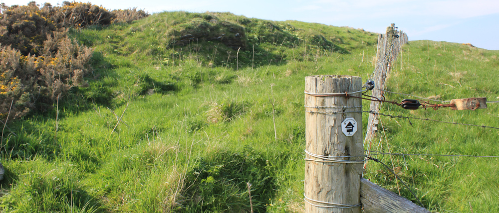
Luckily, the next section is surprisingly easy, with a nice flat path on the inside of the fence. Although it is relentlessly uphill! In the distance is a hazy tower. That must be Ousbacky Lighthouse.
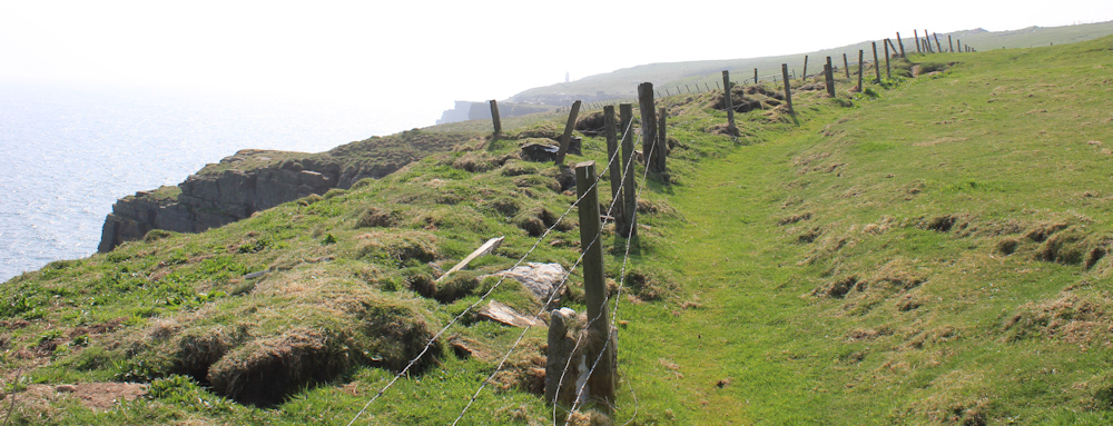
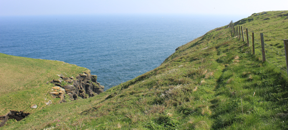
The climb is worth it, because the cliffs are wonderful. Some of them look as if they are constructed with giant building blocks.
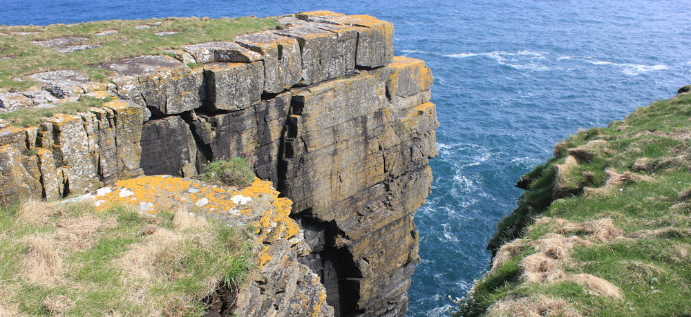
I am walking without the safety of a fence now. The walkers I saw earlier turn out to be rock climbers. I don’t see them, just their packs and lines leading over the cliff edge.

The cliffs are noisy in places – due to resting seabirds. Along with the noise, is the pungent smell of guano.
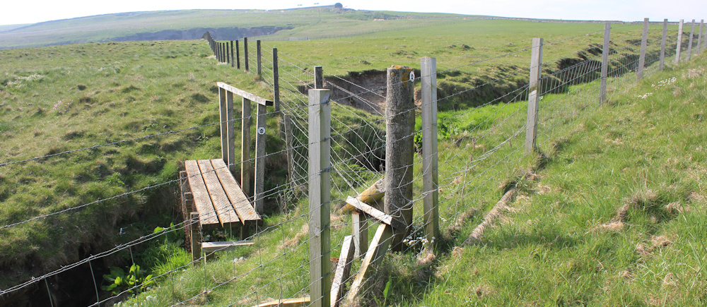
I cross a burn, approached via a very rickety stile, where the land below has slipped away towards the sea.

The stile shakes and shudders under my boots. The wire is too loose to give me any security when I grab it, but I make it over eventually.
A trek round another geo. This one is called, appropriately, Long Geo.

The lighthouse is steadily drawing nearer and emerges out of the haze – a stately white and red striped column. One last long climb and I will reach it.
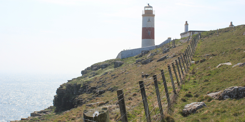
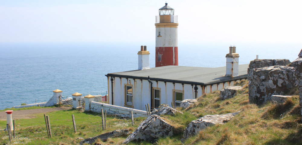
The John o’Groats Trail is signposted round the back of the lighthouse. As I get nearer, the rusty markings and faded paint become obvious. Poor old lighthouse.
The woman walker I met this morning warned me there were cows round the back of the lighthouse. So, I am feeling a little nervous, but the cattle are actually a long way away at the top of a field.
Downhill now, hurrying away from the cows. I stop to look back at Ousbacky (also known as Clythness Lighthouse) and take photographs. There are caves at the bottom of those staggering cliffs.

The next section of walk is along the top of the cliffs, with no geos to interrupt progress. In the sea below are numerous flat-topped rocky islands. Skerries. This one is Skerry Mor, I think.

More rucksacks at the edge of the cliff. More invisible climbers!
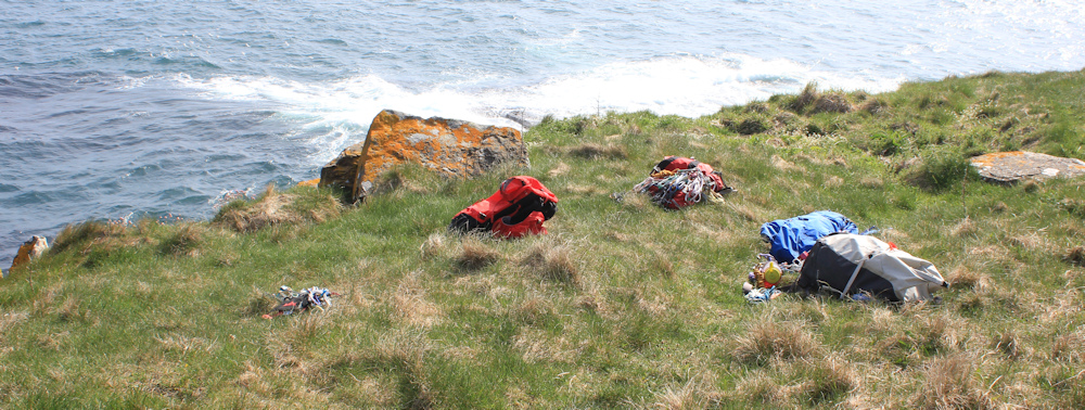
It must be a leap of faith to launch yourself over the edge, with only your thin line of rope to keep you safe. I feel nervous thinking about it.
The next geo I come to has a shingle beach, and a ruined house built into the walls of the inlet. Or maybe it’s not a house, but the remains of an industrial building? Clyth Harbour, says my map.
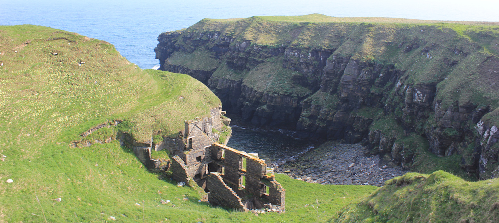
[Later, I learn that the building in Clyth Harbour is an old fish-processing station.]
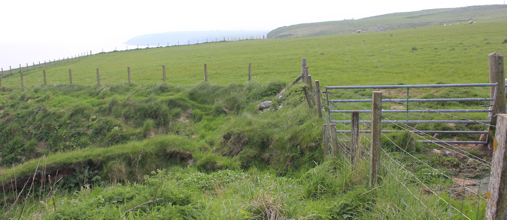
Another rickety stile – this one is broken and completely unclimbable. I climb over the fence instead, although the fence posts wave alarmingly under my weight.
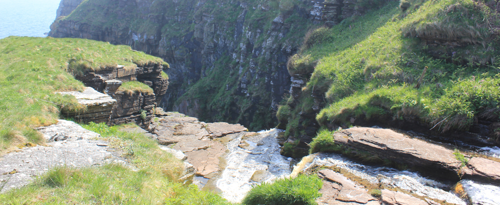
I reach a deep river valley. Impressive waterfall in the distance. Check my map – this must be Occumster.

I walk beside the bubbly little river, heading reluctantly inland. Where can I cross? There must be stepping stones somewhere.
I don’t find any easy stepping stones to use, but make 3 half-hearted attempts to jump across the water.
This is my first attempt – it seems a narrow gap to leap across… but look at the uneven ground on the other side, and the precipice where the water falls in a 100ft (or more) drop down to the sea.
I chicken out, and walk further up the valley.
Here is another place where the rocks seem to provide a stepping-stone route… but the surfaces look very slippery. The waterfall above me is beautiful though.

This section of the John o’Groats Trail is marked as AMBER on their website, where they helpfully warn me of the risks. “Risk of falling when crossing burns. Risk of injury when crossing barbed wire. There is a risk of death from falling off cliffs along most of this stage.”
I dither at this second crossing-point for some minutes, before chickening out again. And then I spot the JOG Trail marker on a fence post – ah, perhaps I need to climb above the waterfall.
At the top of the climb, and well above the waterfall, I spot a welcome sight. A BRIDGE!

And so, I cross the river without risking death, and without even getting my feet wet. Thank you, John o’Groats Trail. You haven’t let me down after all.
The path runs high along the edge of the valley, taking me back towards the coast…
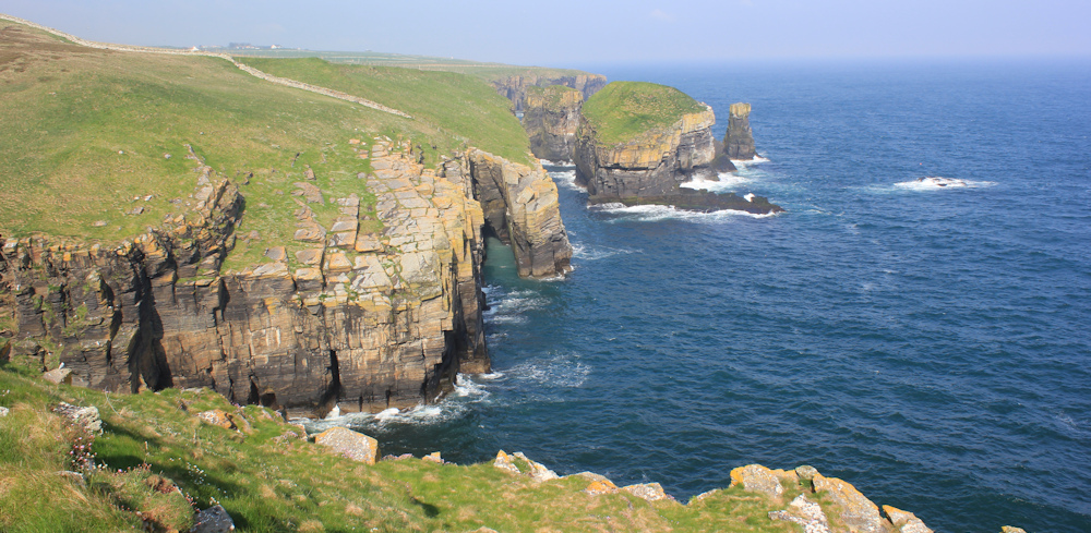
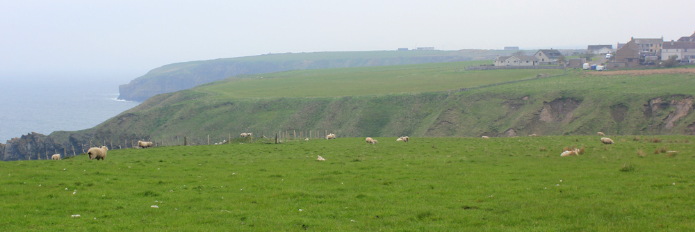
… where there are incredible views along the cliffs looking north. Sea stacks, natural arches, caves, rocky islands. Beautiful.
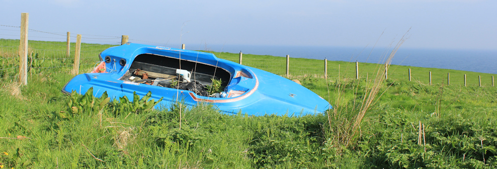
The next section of the coast has some odd features. This promontory is called White Head, but what you will really notice is the abandoned stock-racing car perched on the grassy slope. What on earth is it doing here?
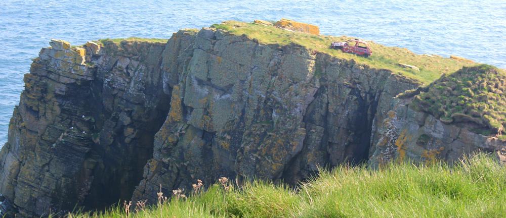
Other walkers have mentioned this strange sight.
Oh, no! What a mess. Someone has tipped a load of waste by the edge of the cliff. How did they get it here? Metal, pieces of plastic, black bin bags, corrugated pieces of iron (maybe), pipes, some wooden planks with rusty nails – what a load of junk!

The path takes me straight through this mess. I stumble around the pile, keeping close to the fence where the ground is clearer. Who did this?
A little further on, and an abandoned boat looks almost picturesque in comparison.
The next little valley should look attractive, but the land has slipped away leaving great scars.

A plank bridge takes me safely over a burn, but the ground is very rough here. I stumble and feel my way nervously along with my pole.
I am tempted to walk on the inside of the fence, where the ground is much flatter, but there are cows in the fields, so I stick to the cliffs.
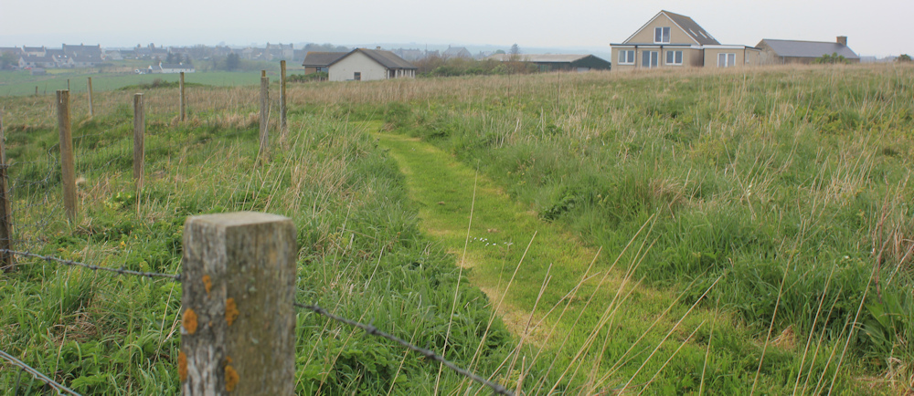
Growing very, very tired now. But, there is Lybster in the distance. I’m nearly home.

The JoG Trail takes me inside a fence and… oh wonderful… a mown green track will lead me straight into Lybster. Excellent. I’m so very tired now.
But no. First I have to navigate a field of sheep and another, and very deep, river valley. I wasn’t expecting this obstruction. Check my map – yes, this is where the Burn of Shalligeo cuts its way through to the sea.
There is a steep grassy slope taking me down to the burn. I pause before I descend and take photos of the little beach beneath me. It really is very pretty… but look at the steep climb up the other side.

I cross the burn using a bridge made of long, flat flagstones, and begin the calf-shuddering climb up the other side. Luckily there are steps… because the slope really is very steep.
To be honest, at this point I feel like crying. I’m so very, very tired, and I wasn’t expecting this steep staircase after miles of difficult walking. Several times, I sit down on a step to gather my energy.
If there was another way off the shore I would take it. But there isn’t. So, up and up I climb.
At the top, an easy path of short grass takes me toward Lybster. Finally, I am nearly there…

… but there is still a long walk along the road through the village to reach my rented cottage.

When I get inside, I collapse in an armchair, utterly exhausted. I’m obviously still terribly unfit following my chemo and radiotherapy. Tomorrow is another day, but I am going to have to reduce my daily mileage still further.
The Ousbacky, or Clythness, Lighthouse was officially decomissioned in 2010. I don’t know who owns it now, but it is need of a little love and attention. Brief details here.
Miles walked today = 8.5 miles (felt like 110)
Total distance around coast = 5,101.5 miles
Route today: morning in black, afternoon in blue


I never expect sunshine in Scotland either, so rarely have sunscreen, and I’m never prepared for it. Anyway, better than forgetting a raincoat😊
You may think you’re unfit, but I did the same distance last Friday and felt shattered, and I’ve not been through anything like you have, so don’t get down about it, it’s a fantastic achievement doing that distance over that terrain. It helps when the sun’s out and the views are beautiful though, doesn’t it.
well done Ruth 👍
Thank you Paul. This was a tough day, but the views were magnificent and the sunshine always helps!
You have no energy, and are faced with a steep ascent!
I know this situation well while walking the SW Coast Path.
Solution: Eat an energy bar, and you’ll breeze up the steep slope!
I always carry Trek energy bars in my Rucksack, and they give you an instant boost!
Wishing you continued good health!
I had eaten all my energy bars at this stage, but they do usually help with that extra boost.
It sounds like this was a bit of a difficult walk Ruth. Thos steps on the steep hillside remind me of a particular section of the Anglesey Coastal Path which I walked about seven years ago. And all that fly-tipped rubbish – for heaven’s sake, why??
Why tip rubbish in such a beautiful spot? And it must have taken some effort to cart it all there. Such a shame.
Well done Ruth ! and wonderful photo’s too.
Thank you Mike.
A tough day, Ms. Livingston, but an important one for your positive outlook. You got this!
An amazing stretch of coast, Ruth. Well done, after all that you have been through.
I remember that rubbish and wish the authorities would clear it or at least prosecute the land owner.
Looking forward to your next section and wish you all the best with your ongoing health issues. You are a hero.
It is a beautiful area and such a shame that somebody would desecrate it with all that junk!
Lovely to read another write up. This is a spectacular (and tough) stretch of coast, as you found. Your write up has made me very tempted to do it again. When I did this walk the John O’Groats trail was in it’s infancy and not really signed and I didn’t know about it. It looks like, dodgy stiles aside, the path has really improved. Sadly I did much of this walk in the mist and would love to go back in the sort of weather you had.
Sorry you found it so tough, but you have been through a lot and hopefully future walks will begin to get a little easier again in time.
It s wonderful to have a coast path here, even if some of it is very much work-in-progress. Well worth revisiting, Jon, maybe in better weather so you can appreciate the remarkable scenery.
That is so well done! And you are soooo brave. Lovely photos as usual….
Thank you!
At least you had magnificent scenery. But that feeling of utter tiredness compounded by a finishing line that seems top lay tricks with you is tough.
It’s good to read of you back on the trail. You are a hero and doubtless an inspiration to many.
The last section of a walk is always the hardest. Mentally, you are already at the end, so an unexpected difficult bit becomes a really hard challenge.
Great to read your latest installment. Don’t knock yourself, the JOT is not for the faint hearted. We are all getting on too! I think you’re doing brilliantly!!!
Thank you Chris. It really is a wonderful trail, but difficult!
Considering the health treatment you have been through and the fact this walk is not classed as easy or gentle, the actual distance walked is irrelevant – we often push through in our minds, so the distance may as well have been 5000 miles. Each morning give yourself a bloody big pat on the back girl – Well Done. Cheers Russ
Thank you Russ. I guess I am just frustrated I can’t walk 12-16 miles like I used to!
Such a wonderful coastline with all those geos. I had to skip that section, so look forward to a return trip, probably when the midge season is at its peak and I flee the NW coast. The JOT may have improved it’s signposting, but it’s still a tough trail. Well done Ruth.
I was worried that the east coast would be a disappointment after the glorious scenery of the northwest coast. In fact, the coastal walking is much better in a way – because you can actually walk close to the sea.
Ruth, I just wanted to thank you for publishing your blog. My husband and I find it so helpful when planning our next days walk. It has been brilliant.
many thanks
Carol
Thank you for your kind words, Carol. Happy walking!
Hi Ruth
Well done – it doesn’t sound an easy path to follow at times. It’s always so disappointing when you think you’re ‘nearly there’ & an extra ‘down & steep up’ gets in the way. You’ve done amazingly well & the scenery does look wonderful.
I’m hoping to do part of JOT in the autumn, but am already feeling nervous about all those Geos!
Hope you’re able to enjoy some wonderful walking this year.
Take care
Rita
Hi Rita, the JOT really is a wonderful trail. Just take your time and you will be fine. I also took kit to climb over barbed wire fences, as you might need to. Best wishes.
Thanks Ruth – I’ll definitely aim for lower mileage totals – looking forward to seeing the beautiful scenery & hoping for an Indian summer! 🙂
I echo all the comments above – you are an inspiration to all walkers, young or old, fit or sick, man or woman – don’t be hard on yourself. I for one am much more of a wimp only managing 7.5miles maximum on Somerset’s flatlands after breaking my the recently. We just do what we can and try and enjoy what we pass through. And you are certainly passing through some amazing scenery.
Hello Ruth, we’ve messaged you before to describe how you’ve inspired us to take on the coast. This week, from 11th to 19th April inclusive, we’re walking another 100 miles or so from Lossiemouth to Cromarty taking us up to around 4,500 miles in all, via Inverness of course, always sticking as close to the sea as possible. We wanted to mention in case you are also walking this week and passing us – we would absolutely love to stop and say hello! Jonathan and Annemarie