

Horses roam freely, New Forest
I set off towards Lymington. This small lane is the official Solent Way. Luckily the road is almost free of traffic today and I make good progress.
I pass an old tithe barn with a green space outside. Horses roam freely on the grass and across the road.
As the road slopes gently upwards, I can see across green fields to the sea and to the Isle of Wight beyond. I pass a information sign and realise this was the site of an important airfield during the war – Needs Oar Point – from which bombers flew in support of the D-Day landings.

Site of Needs Oar Point airfied
Further up the lane I come across an old-fashioned Volkswagon camper van following a smaller car. Both vehicles pull to the side of the road and I am immediately suspicious. I have seen nobody all morning. Why are these people stopping near me?
But it is nothing sinister; only two women, one in each vehicle, and they are lost. They are looking for a place called Sowley Corner where there is a man who fixes these old Volkswagen buses. I get out my map and my iPhone with my GPS. I find a Sowley Pond. It is back the way they came. Is that it? We don’t know but they decide to head back. The road is too narrow for them to turn around in. So they are forced to drive onwards.

A footpath at last!
I continue walking along the road and come, at last, to a footpath sign. It is a relief to be off the road and I really enjoy this part of the walk. I walk along the side of a field and follow the public footpath into a wood. I meet nobody else.
The woods are wild in places with fallen trunks and thick undergrowth.

Walking through the woods, New Forest

Forest avenue on footpath near Lymington
 At the end of this, I come to a kissing gate and an omninous sign. “Beware of the Bull”.
I look around. The public footpath leads into this field. I can see no bulls. I continue and realise that the field next to me is where the cows are and, maybe, the bull in the distance. I am safe on this side of the fence.
Safely through the field, I walk through more woods. I hear the sound of things falling from the trees. At first I think it is acorns but then I realise it is horse chestnuts (conkers) falling around me.

Endless road walking - no coastal footpaths in the New Forest.

plastic tunnel green houses, approaching Lymington

Isle of Wight Ferry Port - Lymington

I walk past the ferry port and head down the road along the river towards Lymington. It is late and I am hungry – so I am very pleased to spot this attractive pub. When I walk in, I am the only customer.
But it is bank holiday Monday and they don’t do food. What a disappointment!
 The young bar man tells me there are plenty of places to eat in Lymington. I consider buying a bag of crisps but decide to continue onwards and find a proper meal.
The road leading into Lymington is busy and I cross over Lymington River, heading into the old part of the town.
I notice the ‘Otters Crossing’ sign. I have never seen this before. Not that I think it does much good to have such a sign. The cars whiz by at a fair speed anyway.

Train & boats -Lymington River.

Lymington water front.
From the pub, I can look across the water at the boats moored in the calm water by the bridge. And, an added bonus, I can watch the trains go by on the other side of the river – heading for the Isle of Wight ferry terminal.

Boats at mouth of Lymington River.

Lymington Marina
From here, I walk along the waterfront. There is an outdoor seawater swimming pool – looking rather sad at this time of year with no water and no bathers.
I head past the bustling marina at the mouth of Lymington River and come to an area of open land with a series of ponds – and with paths winding around them. This strip along the shore is shown on the map as being a National Park and signs tell me this is the Lymington – Keyhaven nature reserve.
Now I find there are plenty of footpaths, including one right by the water – at last, I can walk by the sea – with great views across to the Isle of Wight.
So the last four or five miles of this walk turn out to be the best section of the day’s walking. Unfortunately, the clouds have come over and, as the sun sinks lower, for much of the time the light is too dim for good photography.

Portsmouth in the distance.

View over mud near Lymington.
The tide is out and there is plenty of mud to see.
The walkway through the nature reserve is well maintained and flat. At first I meet plenty of families with pushchairs and people with dogs but, as I leave Lymington further behind, I find I am on my own, apart from the occasional jogger.
This has been another long walk (by my standards) and I am getting tired.

Path through Keyhaven Marshes
I am pleased to see Keyhaven ahead. This is a lovely place and I approach it across a bridge.

Unfortunately, there is nowhere to sit in the middle of Keyhaven – just a large car park. So, while I wait for my husband to arrive to collect me, I am forced to visit the pub. It is early, only just 5 o’clock, and I find the pub door is shut. While I wait outside, a few people join me. By the time the landlord arrives to open up, quite a queue has formed – but I’m in the front!
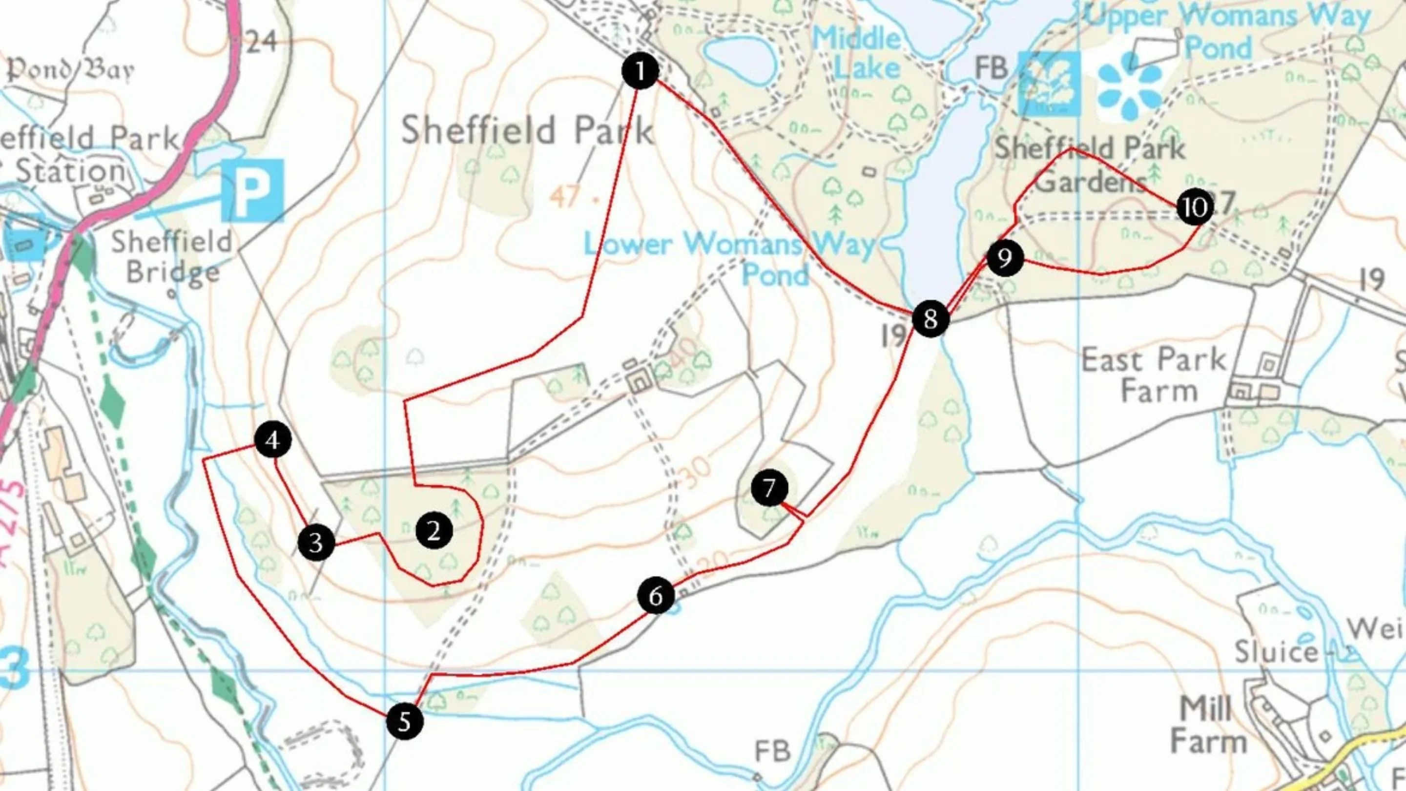
Vital stats: Miles walked = 14
Route:


You walked such a long way. I have never walked that far. Nice pictures.
Pingback: Shoalstone Beach
Agree with Connie! I love walking as well, but for such a long trek I would get a big group of friends and walk for charity like this
Ah, but I don’t want to ask other people to PAY me for doing something I want to do, even if I then hand over that money to charity. And wouldn’t it be easier just to ask the donor to donate straight to a charity of THEIR own choice? (As you may gather, I am not a big fan of sponsored activities.) As a reasonably well paid professional, if I really wanted to raise money for charity, the most effective way to do it would be to WORK for a day instead of walking for a day, and then give all my pay to charity.
Lymington is one of my favourite places and the walk along the sea wall is lovely.