
It rained all night and I was expecting rain today. Instead, I find a grey, moist blanket of fog covering the higher ground of the coast and blurring the boundary between sea and sky. Inner and Outer Hope are no longer sleepy, seaside villages. They have been transformed into mysterious outposts where smugglers and sea monsters lurk in the mists.

I leave Outer Hope behind and follow the South West Coast Path upwards over the top of low cliffs, heading north along the coast towards Thurlestone and Bantham.
 This should have been a beautiful walk.
Yesterday, I could see this same path rolling over the cliffs – called The Great Ledge on my map – with dramatic rocks rising from the sea just below and, in the distance, the mound of Burgh Island with its bright strip of sand connecting the Island to the mainland.
Today, I can’t see anything much: just the red mud of the path underfoot and the grey mist all around.
Sometimes the sky lightens, bringing hope that the sun will shine through and the fog disperse. But it never quite happens.
Coming down off the low cliffs, I reach Thurlestone Beach. At one end there is a complex of apartments. At the other end, is the village of Thurlestone. Between the two is a long stretch of sand and I enjoy walking by the waves with only a few keen dog walkers for company.

At the far end of the sand is a golf course and, from here, the path rises up and crosses a wild area of high ground, before reaching the mouth of the River Avon ahead.
 I really enjoy this section of the walk, despite the weather. With poor visibility, and no clear view more than a hundred yards on any side, I feel I am out on a wild, stretch of coastline and miles from any civilisation.
The rocks below are just visible through the mist – ominous jagged peaks rising up from the sea with broken white water swirling round them. I can imagine lost sailors and shipwrecks.
In the summer, with bright beaches behind and ahead, I am sure this area would be beautiful but tame. Today it seems magnificently wild.
Eventually, I come across a barbed wire fence and the path begins to slope downwards as it heads towards the mouth of the river Avon. The fog becomes less dense as I leave the high ground.
 Just inside the mouth of the river is a lovely beach – Bantham Beach. There is a lookout station here and a car park. Long, rolling breakers make this a great spot for surfing and other water sports. I imagine it becomes busy in the summer.
On this dismal day, there are only a few dog walkers out. I watch a sheep dog (a collie) chasing the waves up and down the beach.

On the way into Bantham, I spot an acrobatic slug on a bracken stalk.


It is the palest yellow colour and appears to be doing slow somersaults, using the stalk as a trapeze.
After a while, I realise the creature has crawled to the top of the stalk and, finding itself suspended in mid air, isn’t sure what to do next. I bend the bracken leaf over and deposit the slug on the ground.
In the summer there is a passenger ferry across the river, from the village of Bantham to the tiny hamlet of Cockleridge on the other side. Unfortunately, this ferry stopped running in October and I will be walking upstream to the nearest bridge crossing – at Aveton Gifford.
According to my map, there is a public right of way running up the estuary and it starts off along a track before dwindling into a footpath. But I almost miss the start of the walk, being tricked by a farmer’s misleading sign posts.

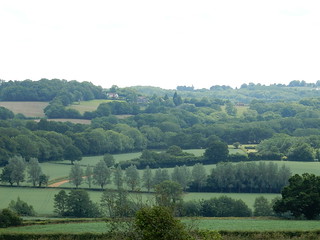
In the summer, this would be a beautiful walk. And for a brief five minutes, the fog lifts somewhat and I am able to take this photo of the view looking back down the river. I can even make out the mound of Burgh island to the right of the photo.

The main problem today, apart from the fog, is the mud. This is the muddiest walk I have ever done and I am really grateful for my poles – without which I would surely be ending up either flat on my face or sitting on my bottom in the muck.
I am wearing new boots – soft ones made of fabric. My old leather boots finally gave up and developed cracks. Today I will find out if my new boots really are waterproof, as promised by the shop.

At one point, the footpath crosses over a farm track. At this crossing point, the mud is incredibly deep and soft and mixed with manure and churned up with animal hoof prints.
It is almost impassable. I am nearly forced to give up.
To make matters worse, I am not even sure if I am on the right path, as there are no footpath signs to guide me, only a hostile gate with barbed wire woven through it.
Now, I know farmers have animals and I know they have every right to let their animals have free roam, but I do think there is also a responsibility to keep public footpaths reasonably clear and passable – either with a layer of gravel or some flat stepping-stones or a few planks of wood. And some decent footpath signs would help!
From here the path crosses a field and keeps to high ground, overlooking the river valley. I am grateful for the grass. It is still slippery and difficult to keep my footing on the sloping ground, but at least there is less mud.

At the end of the field, the path winds through woodland. At last I find some proper footpath signs to help me keep on the right track.

I cross a stream and walk up a very steep hill, before arriving at a farm and I see, with relief, the path now follows a proper track. I meet a couple of walkers – the first people I have seen since the dog owners on the beach.
“It’s wet ahead,” they tell me. “And you have to climb over gates.”
The track forks and I take the left hand route, which should take me down to Bridge End and across the Avon to Aveton Gifford.

This is a delightful track. I think it is probably a very ancient Devon road, dating from before the time of cars, and I can imagine it was once used by coaches and horses. The walls on either side are deep and trees arch overhead.
I am walking in a green tunnel. Lovely.
And it is also very wet. Water is running off the surrounding fields – sodden after weeks of rain – and washing down the track. In fact, as I walk further along it, the track turns into a shallow river. Luckily, the water is clear and seems to have washed away the mud, leaving a firm base of stones underfoot.
The water also washes the mud from my boots and – much to my delight – I discover my new boots are, indeed, waterproof.
At the bottom of the track there is a closed gate and the latch is impossible to work. I do have to climb over – as warned by the other walkers.
I arrive at Bridge End. There is small river tributary winding around and some old, abandoned boats.

At Bridge End, I meet the A381 and I follow the road as I walk into Aveton Gifford. Some sections of the road are OK, with a nice footpath running alongside.

But there is no footpath over the bridge – neither is there a pavement – and I am forced to walk along the road itself, with cars and lorries passing very close to me.

Aveton Gifford is where I am staying this evening, in a B&B with my husband and his mother. Walking through the village, I pass a comfortable looking pub and am very tempted to go inside. But my boots are dirty – and I have mud splashes on my jacket and trousers. I decide to go straight back to the B&B and have a soak instead.
Miles walked = 8
High points = Bantham Beach
Low points = mud near Aunemouth
Route:


Oh dear Ruth – it’s just after Christmas and still raining, to the extent that I read they are recommending staying away from the South West Coast Path due to the threat of landslips. I hope you are able to continue on your travels soon! Nic
Pingback: 97. Aveton Gifford to River Erme | Ruth's Coastal Walk (UK)
A lovely stretch of coastal path Ruth. Being mainly on the level we made remarkably good time. If anyone else wants the bus (there is no bus stop) then you wait outside of the church. The bus takes you back to Hope Cove 3 times a day. Last bus 17:46! We got there with one minute to spare!
Glad you made the bus, Anita! And thank you for posting useful information for other walkers.
Hi Ruth, I’m still following along with your walking blog.. I am probably catching up with you slowly as I try to read a few posts a day when I can. I’ve actually read all the way to St.Ives, but I’m posting back in this post of yours today, as I did a small digital painting of a natural arch off Thurlestone Sands last night from a photograph that I took when I walked this stretch a couple of years ago walking in the opposite direction. I’m trying to teach myself to paint digitally using a graphics tablet at the moment! It was definitely better weather than your experience! Here is a link to the painting on my art blog…http://matthewallton.blogspot.com/2020/02/natural-arch-off-thurlestone-sands.html . Looking past the arch formation (Book Rocks?) you can see Bolt Tail beyond Inner and Outer Hope.
Hi Matthew, and thank you for posting a link to your painting. Really good and certainly captures the atmosphere on a better day!