
The sun is shining. From the garden of my B&B in Kewstoke I can see right across Sand Bay to the peninsula of Sand Point. The air is a little hazy, but it’s still a beautiful view.

My husband has returned to Lincolnshire for the day, unable to get GP locum cover for the complete week. Without him I have no transport and there are no useful bus routes. So I have planned a circular walk: down the beach to Sand Point, around the far headland – an area known as Middle Hope – and then back up to my B&B via country lanes and bridleways.
It’s a short downhill walk to the beach. Sand Bay is a great name and very fitting for this unspoilt two-mile strip of coast. I may be very close to Weston-Super-Mare, but it seems a different world.
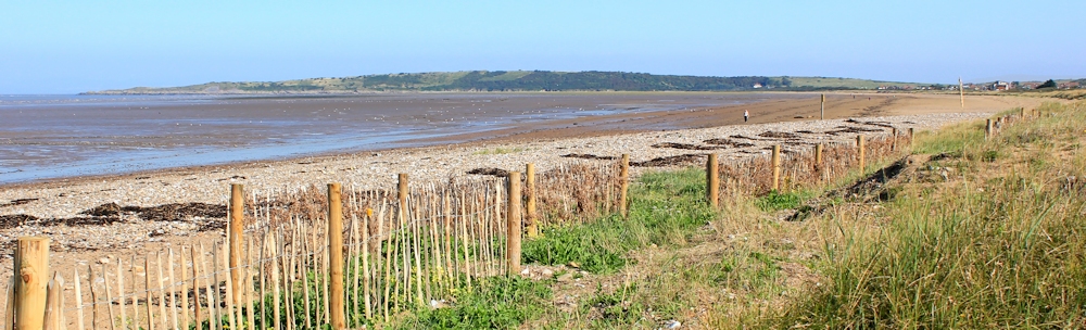
A low dune system gives way to a sandy beach, with a wide, muddy, intertidal area below. Wales is visible in the distance. I see the usual warning notices. Sinking mud. DANGER!
 I walk along firm sand, close to the border where it turns to mud. There are plenty of lug worm casts and sea birds to keep me company.

It’s very peaceful, with only the occasional dog walker on the beach. After all, it’s a Tuesday morning. Everybody should be at work!

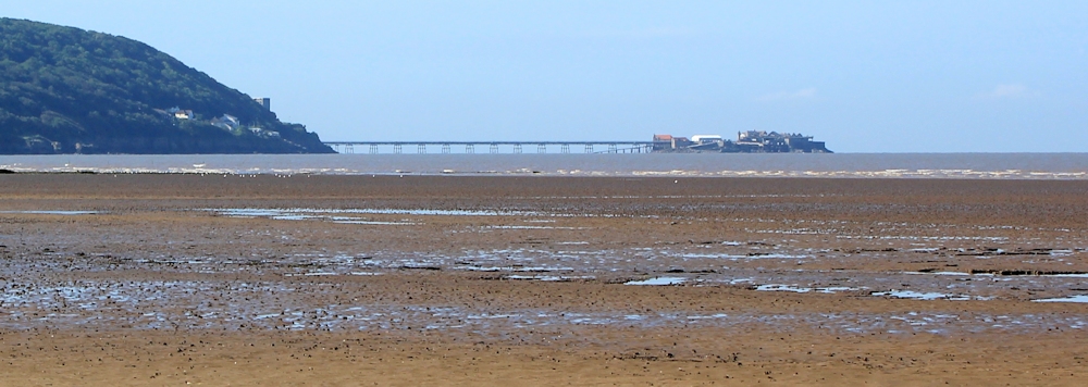
At the near end of the beach I can look across the water and see the ruins of Birnbeck Island.
And, ahead at the far end of the beach, the peninsula of Sand Point draws slowly nearer. I’m not expecting much from this piece of land. It seems to be a lower, smaller, less-dramatic version of Brean Down.

I’m sad when the beach comes to an end, and the muddy sand gives way to rocks, with marsh and grass above. I follow a track through the grassland.
The vegetation here seems unusual. Reeds and grasses, of course. A few lost-looking brambles. And this tropical-looking yucca plant.

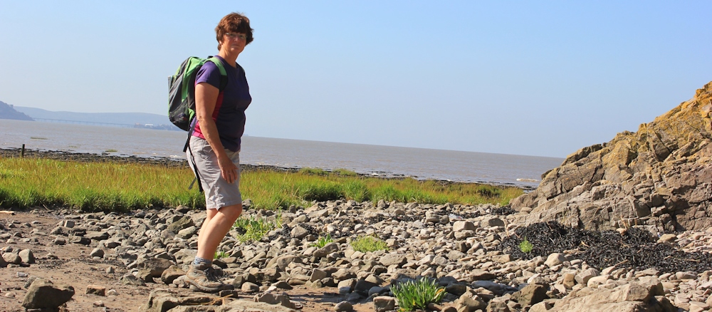
When I reach the peninsula, I turn and walk towards the sea, keeping the low cliff on my right and hoping to find a place I can scramble up. But I don’t see any obvious track and eventually I reach the water’s edge, where I stop for a drink and watch the tide coming in. And take a self-portrait. (Not bad. Shame about the wonky camera angle!)
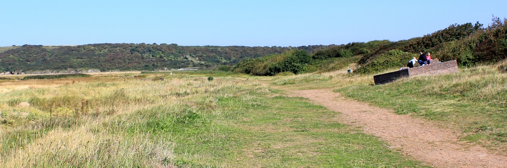
Turning back, I go to the top of the beach and find an information board and a car park, and a few people milling about. Sand Bay and Middle Hope. I realise much of this raised finger of land is owned by the National Trust.
Following the proper path, I climb up. It is steep, but nowhere near as challenging as Brean Down.
The view from the top would be spectacular if it wasn’t for the haze. The nearest headland across the bay is Worlebury, covered in woods and where I walked with my husband yesterday. The farthest headland is Brean Down. Barely visible.
 There is a gently undulating path along the top of the ridge. A few families are up and walking ahead of me.
 I walk almost to the end. Sand Point. The path deteriorates into a rocky scramble along a narrow ridge. I give up when it turns into a hand-and-knees job. (It’s good to see the National Trust haven’t felt the urge to make the place ‘safe’. There are no warning signs, no concrete platforms, no guard rails.)
On the way back, I take another self-portrait.
 And the next part of the walk turns into the best experience of the day. I walk along the north shore of the peninsula, and can see the land extends further than I had anticipated, giving a couple of miles of excellent walking, as good as you might find in Devon and Cornwall. (As long as you ignore the brown sea.)

[Later, I discover that Sand Point marks the boundary between the Severn Estuary and the Bristol Channel. So, this section of the shore is no longer seaside but estuary. Strange. Because it feels more like wild coast than much of the walking I’ve done recently.]
There are unexpected, pebbly, beaches.
 And strange raised hills – tumuli I believe – with ridged slopes.
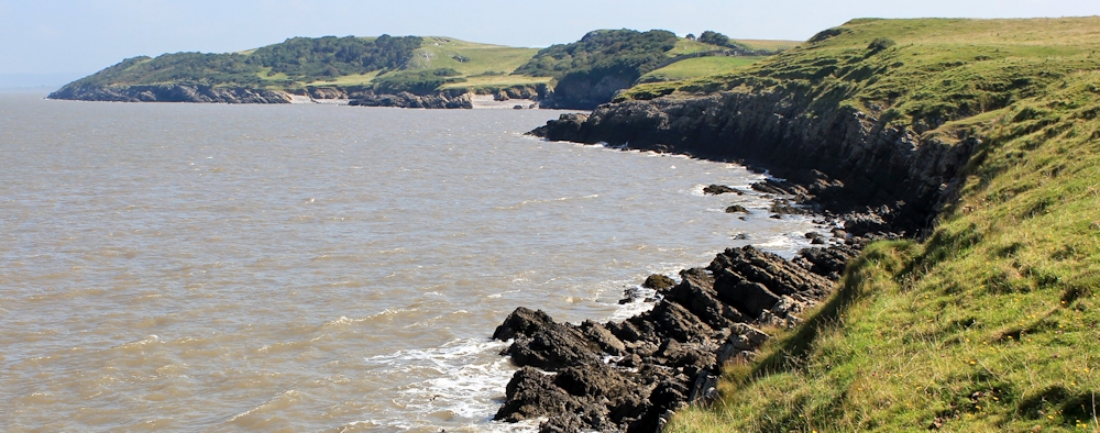
 Rounding the corner, I see a series of small coves, and dramatic rock formations. Later I learn that Middle Hope is famous for its wonderful and varied geology, including limestone rocks, lava from old volcanos, and fossils.
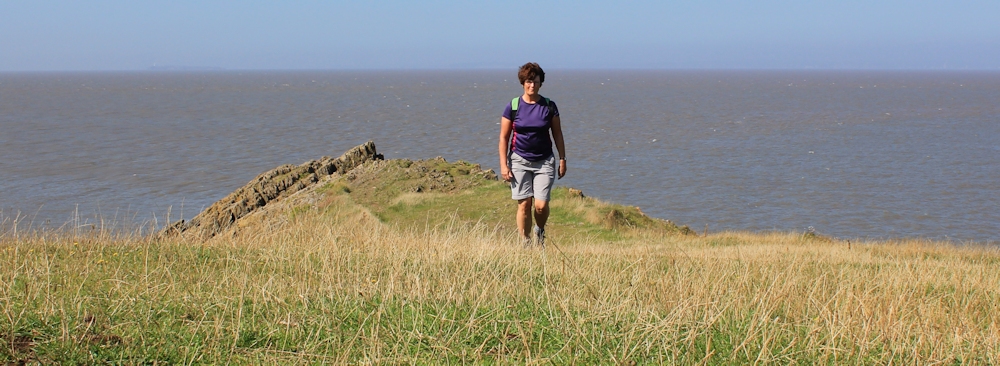
 I meet a couple of walkers and turn around to take a photograph of them walking alongside one of the beaches.
 Like Brean Down, Middle Hope was also used as a testing place for experimental weapons during World War 2.
 A damaged warning sign gives a hint of remaining armaments, without mentioning the word directly.
 THE MUD ON THIS FORESHORE IS VERY TREACHEROUS AND MAY CONCEAL SHARP OBJECTS. PLEASE KEEP OFF.
There is another, and similar, sign fixed to a steep stile.
At this end of Middle Hope, there should be the remains of a field-system from the middle ages. I stumble over uneven ground, so may have found the old ridges. I don’t know.
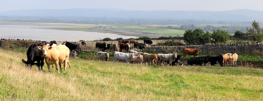
And then I meet some familiar foes. Cows! I was attempting to follow the coast as closely as possible, but with this lot across my path, I give up and turn inland. (It’s not possible to walk all the way around the shore anyway, because the farthest tip is MOD land and fenced off.)
As I come over the ridge, I see the flat lands of Wick St Lawrence and Kingston Seymour spread out below me. Tomorrow, I am planning to walk to Clevedon, just 3 or 4 miles away along the coast. But there are no public rights of way and no obvious footpaths on my map, so I anticipate a difficult inland trek. (But that sea wall looks so tempting… I wonder if it’s worth trying another bit of trespassing…)

I turn to the south. I’ll worry about Clevedon tomorrow. Today I am going to enjoy the rest of this walk. Ahead is Woodspring Priory, built by one of the gents who murdered Thomas à Becket, now owned by the Landmark Trust. The high ridge beyond is Kewstoke, and my B&B is there, hidden somewhere in the haze.

The footpath leads down along the side of a creek at the mouth of the River Banwell. The tide is high, for a change, and I really enjoy this section of the walk.

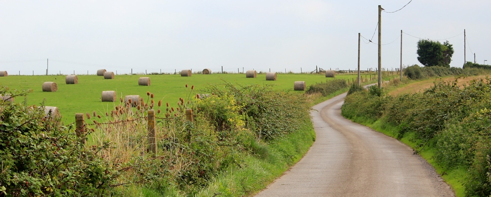
I follow the narrow track from Woodspring Priory to the nearest proper road. I am surrounded by farmland and the main crop seems to be grass. Hay bales glow in the afternoon sunshine.
 The bridleway I planned to follow disappears into a field of tall grass, leaving me stranded in a meadow surrounded by thick hedges, with no clue as to where the route goes. So I turn back to the road and find another bridleway. This one starts as a surprisingly narrow path and is bordered by high hawthorn bushes that meet overhead (very scratchy if you were actually riding a horse!).
Later on it becomes an easy track, running alongside one of the many waterways that crisscross the Somerset Levels. In the East Anglian fens we call these drains or dykes. In Somerset they call them rhynes. At least, that is what they are called on my OS map. (I think rhynes is a pretty word, but when I mention it to our landlady she says she’s never heard the name, despite having lived in Somerset all her life. )

The track is marked on my map as Elmsley Lane and it gradually widens and becomes more and more road-like, until it eventually turns into a proper road.
I enjoy this last section of my walk, despite feeling unexpectedly tired.
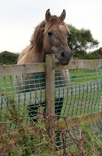
 No view of the sea, of course, but a true rural feel. Tumbledown barns, weathered stables, friendly horses, a donkey, goats, strange abandoned machinery, chickens, pheasants – a proper country walk.
And a carpet of lovely yellow lilies on the rhyne.
Miles walked today = 9.5 miles
Miles walked since the start of my round-the-coast trek = 1,546
Route:


Rhyne is pronounced ‘reen’, so if you pronounced it ‘rine’ you might have confused her. Not that it would be hard to figure out though.
Did you catch sight of the Severn Crossing from Sand Point? It should have been visible from the top (haze permitting).
Hi Ju. No, didn’t see the Severn Crossing. It was too hazy. And thank you for pointing out the correct pronunciation of rhyne. Of course I said ‘rine’ and so, of course, she didn’t understand the word!
I was born in Weston and brought up in Sand Bay we always called the them rhynes or ditches depending on the size of them. I enjoyed finding your blog it was like a trip down a very familiar lane. Thanks
The beach was a lot different in our childhood being very pebbly at the Kewstoke woods end and becoming more sands and dunes at the sand Point end.
After the storm in 1981 when the sea breached the wall and caused widespread flooding My Mum and sisters had to wade out to Kewstoke to the safety of an Aunts house.
Dutch engineers were brought over to dredge and and change the shape of the beach to build it up covering the familiar pebble beach at our end. Hoping to avoid further floods. Since then a lot more sand blows up and onto the road making the area seem more rugged and desolate.
Hi Jane. What a lovely place to spend your childhood. Interesting to hear how and why the coast was changed in the area. I thought it was a fabulous beach. Miles better than Blackpool 😉
That haziness persisted for most of the twenty days of my recent walk and is reflected in many of the photos. Headlands some distance away which would normally be quite spectacular just dissolve. Autumn and the frosts provide a better time for photography. How do you do those selfies? Do you have a tripod?
I’m amused about your aversion to cows. I just walk past them and only ever had one tricky encounter, but they stampeded away from me and crashed through a fence to disappear goodness knows where…. but horses… they worry me. I just can’t tell what they are thinking or likely to do.
It’s frustrating, isn’t it, when you *know* the view is spectacular but you can’t actually see it 🙂
The selfies are taken by perching my Olympus camera on any available rock or post, and using the inbuilt timer. I’ve thought of getting one of those Gorilla tripods, but decided not to as it’s just another thing to weigh down my rucksack with.
Cows. Hmmm. I’m getting better with cows. But I’ve had a few nasty experiences recently. The worst was when I walked towards a cow standing on the path, chanting to myself ‘I’m not afraid, I’m not afraid.’ The cow moved away, to reveal the large bull standing just behind her. Ring through the nose. Head lowered. I turned off the path and scampered to the edge of the field and made a long detour.
Had you continued beyond those cows, you would’ve indeed come to an abrupt dead-end with fencing for military land but right before that, you could’ve found an old pier and a pond-like body of water before that – these are things I only discovered last summer!
Woodspring Priory’s church is worth a visit in the daytime as I’ve been told they have some kind o art exhibitions inside. I intended to go last summer but we arrived 30 minutes after they’ve closed at 15.00!
I missed out on the old pier. And I’m sorry I didn’t try and visit Woodspring Priory, but I think it was closed too. (Isn’t it silly how early everything closes?!)
Yet another lovely walk. I wonder how that yucca got there? It certainly isn’t a native.
Thank you for inspiring us to do this… the point was amazing.. tide race on a spring tide… plus the dreaded heifers were in another field…the Commodore hotel in keystoke
village we found did an excellent carvery
It’s a lovely and undiscovered area. Shhh, don’t tell everyone 😉
And I ate several meals at the Commodore Hotel. Huge portions. Good range of choices.
Thank you for posting this walk. It certainly is spectacular, but given the terrain it will probably deter some walkers, especially when approaching Sand Point. We walked it today on a beautiful winter’s day but in very high winds and got a little bit nervous towards the end. We noticed what appeared to be a tremendous battle going on between the incoming sea tide and the outgoing water of the Severn Estuary producing a dramatic wave pattern. I have a photo but don’t think I can attach it. We could see the new bridge as well by the way.
Hi Andrew. Yes, I can imagine it would be a very dramatic and slightly intimidating walk on a wild and windy day. Hope you enjoyed it all the same!
Hi Ruth,
This was a lovely read! I know you published this a few years ago now, but I found this searching on Google for information on Sand Point as I’ve just been writing about my walk doing a very similar route this past weekend. I found the coastal path along Middle Point glorious as well – so much countryside to take in accompanied by the sea air.
Amazingly, in Weston Woods next to Kewstoke I was confronted by a little roe deer walking along the path… I couldn’t believe how close it got – and I just managed to capture it in 1 second video which I included on my blog: https://weekendwalk.co.uk/sand-point-and-middle-hope-walk/
Hope you don’t mind me including a link, I kinda just wanted to share my walk with you after reading your post and especially the clip of the roe deer! 🙂
Steph
Hi Steph, how lovely to hear from you and read your account of the walk. It’s a beautiful area, and I really enjoyed walking this section. How lucky that you met that little deer, and even luckier to capture it on video. So sweet. Your blog is lovely and you give such a clear description of the route. Well done!
Thank you so much for your kind words Ruth, it means a lot! I’ve spent a little while exploring your websites today and feel so inspired! 🙂
The coastal path seems such a huge undertaking, but I love that you are taking it bit by bit and still have time to do lots of other walks too. I’m walking the Cotswolds Way this year as my first big challenge – doing it in two parts over several days. I can’t wait to get going (and to write about it)! Now I’m thinking I’ll have to add the coastal path to my list after reading your blog! 🙂