
The next morning the ground is crisp with frost. I could follow the main A493 towards Fairbourne as it hugs the coast. But the traffic is heavy and I decide it’s too dangerous.
The official Wales Coast Path climbs the hill above Llwyngwril, first following a small lane and later farm tracks. In the fields I see farmers on quad bikes. This one is scattering feed while his sheep follow behind.

The Wales Coast Path leads up and up and up. My calves begin to ache, while Llwyngwril dwindles below me.

According to my landlady, the giant Gwril lived on the coast at Llwyngwril. His cousin, Idris, lived on the mountain of Cader Idris. The two giants quarrelled and threw stones at each other. You can still see these stones where they fell short and landed on the hill tops between Llwyngwril and Cader Idris.
To access the first set of stones, I have to leave the Wales Coast Path and follow another footpath as it climbs higher up the hill.

Other people might consider these to be ancient standing stones, placed by humans in the pre-history era. But I like the giant story better.
Back on the Wales Coast Path, I continue along the high ground, with wonderful views over Barmouth Bay ahead. In the clear air, both Fairbourne and Barmouth look very close.

I’m walking in a north-easterly direction along the slope of the hill, following farm tracks. The long shadows keep the ground frozen. There is ice instead of mud, a welcome change.

Down below I see a post office van bringing the mail to a small farm cottage. I wonder if it was the same one I saw yesterday. Those little red vans really do get everywhere.

There are some pools high on the hill – blue water reflecting the light from the clear sky.

My path continues as a tarmac track alongside a dry-stone wall, with its shadowed verges still covered in frost.

On the bare slope higher up I find some more standing stones. One has fallen and lies with strange markings scarring its surface. I can’t resist using one of the stones to take a self-portrait.

Onwards, and I am above Fairbourne (hidden under the roll of the slope in the photo below) and Barmouth is close, just across the mouth of the river, with more mountains in the distance. Wonderful view.

To my surprise the path veers inland and turns into a minor road. I meet my first traffic of the day, a 4×4 vehicle. Looks like a farmer behind the wheel.

Then the road begins a slow descent and I come across my third set of standing stones. Only a couple remain upright. Those giants could certainly hurl their rocks some distance!

And now I enter a forestry area. Several large machines are parked in the rutted mud, while broken trunks lie strewn around in all directions. I always hate to see felled trees and the scars of logging. It seems such a desecration of the landscape.

There is nobody about. Perhaps it’s too cold to work? The ground is still frozen, despite the sun, and I slip several times where vehicles have created icy slicks on the road.
I’m glad to find Wales Coast Path signs pointing off the road and along a grassy track. Running between dry stone walls, it leads me down past the Cyfannedd-fawr farmhouse.

At first I think the place is another abandoned ruin, but as I get nearer I realise its someone’s home, although I see nobody about.
 Around the side of the house, overlooking Barmouth Bay, they’ve created a stone seat and a marker plaque pointing out features in the landscape. It may be faded and smudged, and definitely very homemade, but it’s a nice touch.
I take the opportunity to grab a brief rest.
The I follow the path, jumping over a stream, and continue winding down the hill across frosty fields and through tangled woods.

The trees make a change from the bare hillside, but I’m glad of the occasional footpath marker post. It would be easy to get lost.

Occasionally I get glimpses down to Fairbourne, which sprawls across a flat piece of land in front of Barmouth Bay.

The path leads down to a quarry track and, at the bottom of the valley, joins a quiet road. There are parked cars here, and I meet a few dog walkers, the first people apart from farmers I’ve seen all day.
The quiet road leads onto the A493. I was expecting to turn off to the right along another footpath, but the route of the Wales Coast Path must have been changed since my OS map was printed. The sun is behind the steep hills to my left and the road is in darkness. I feel sorry for the people who live in the houses down here. It seems very gloomy.
I follow the A493 south-westwards for a short distance, before the coast-path signs point me down a minor road, under the railway line, and to the shore. Here there is an esplanade and a series of concrete sea defences above a beach of large pebbles.

I follow the walkway along the shore past Fairbourne. I was hoping to find a pub or cafe for lunch, but can’t see anywhere open. After a mile or so, I leave the houses behind. Now I’m walking along a dead-end piece of land, a strip of vegetated dunes that runs between the shore and the marshes.
A toy train trundles past on a miniature track. It’s a surreal sight because, although you can’t tell from the photograph, the engine is running backwards. Further along I discover they’re making repairs to the track, ready for the summer tourist season.

As I get nearer to the end of the bar of land, I walk along the top of the dunes, and then along the edge close to the shore. Across the water is Barmouth. So near! In the summer there is a ferry operating but, like the miniature railway, it’s closed over the winter.

At the end of the spit I see there’s a café at the tiny rail terminal. My heart lifts. But the café is closed too. I begin to follow the track back to Fairbourne, this time walking next to the river and its marshes.
Finding some flat rocks, I stop for a picnic of snack bars and nuts. Although the clouds are beginning to pile up over the mountains, it remains sunny and my lunchtime view is wonderful! Running across the river is the long line of Barmouth Bridge. That’s where I’m heading next.

I continue back along the spit. Rain clouds are gathering over Snowdonia, and their dark masses against the sunlit sand and marshes create dramatic landscapes.

Now I’m back on the official coast path again, which curves around the edge of the marshes, running on a raised causeway. It’s a cycle way, a walking route, and a bridleway.

Past the station of Moira Mawddach – a station in the middle of nowhere that must serve only tourists – and onto Barmouth Bridge. It’s a toll bridge, although no vehicles are allowed – only cyclists and walkers. And trains.

The first section is a long viaduct, before I reach the more conventional metal section of bridge that passes over the river. Along the way I meet other walkers and plenty of cyclists.

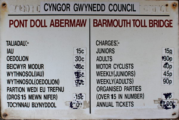
At the far end is a toll booth. I sign tells me it should cost 30p…
 … but the booth is closed. What a shame. I’d be happy to pay. I look for an honesty box, but there isn’t one.
This wonderful footpath across the bridge faces possible closure as a cost-cutting measure. Apparently the local council pays Network Rail £30,000 a year for the privilege of the footpath. Why? Network Rail is effectively a nationalised company and I don’t understand why it should charge anything for this amenity.
A few months ago I signed a petition to keep the footpath open. I’m not sure what difference a petition makes, but there are nearly 50,000 signatures collected so far.
I stop for tea and cake in Barmouth. Then continue along the esplanade.

I’m catching the train back to Llwyngwril, but the service only runs every 2 hours and I have an hour to wait. So I decide to walk on to the next station, a couple of miles up the coast. I must get a move on.
At a quick-march pace, I leave Barmouth behind.

The esplanade comes to an end and the official coast path veers inland. I look ahead along the beach. The tide is out and the sand looks inviting. Could I make it to the next station along the shore?

I spend a moment or two dithering. But, with only 1/2 hour left to go, I don’t want to run the risk of missing the next train. I head inland, over the railway line, up the low cliff, and join the road. At least it has a pavement.
There’s a pretty church and graveyard at Llanaber. Great views. I snatch a quick photo before hurrying onwards.

Just beyond the church is a sign post pointing to the ‘Gorsaf’. Even without the English translation underneath, this is one Welsh word I actually know. Station.
And there it is, down a narrow path. A tiny station – like most of them are – and a request stop.

The evening sun is low, bright light slanting across the bright sea. But overhead the clouds are dark and hail begins to fall. I pull up my hood, but don’t dare duck into the train shelter. The train won’t stop unless I signal the driver.
Here it comes. Slowly. There are multiple level crossings and tiny stations along this line. The train never picks up much speed.

I wave. The train stops. I climb on board, grateful to escape the hail.
It’s been another glorious day of walking, with a bit of everything thrown in: hills and mountains, dunes and marshes, through frost, sunshine and hail.
Miles walked today = 14 miles
Wales Coast Path = 647
Total distance = 2,254
Route:


This looks a brilliant walk, especially those views down from the hills to the estuary, I am particulary looking forwrd to this walk. That bridge is wonderful I think I read somewhere it is the longest wooden bridge in the UK (possibly Europe too?) and I think it costs a lot of money to keep open. I have heard about the proposals to close it to pedestrians and I find it baffling. Network Rail must have to keep it structually sound so that the trains can run along it, so the extra cost of maintaining the footpath must be tiny in comparison. I suspect if they do close it they will have to contend with pedestrains walking on it between trains (as you say, they are not frequent). I know Network Rail had a problem on the Kent Viaduct (I think it is) from Arnside where there is no footpath so people do walk over it, so there they have a signal box at each end instructed to look out (and fine) anyone walking over it. I imagine if they try to close this one they might have to take similar measures. Would be a real shame to lose it, although I can’t imagine a toll of just 30p is even worth the cost of paying someone to collect it (perhaps why the booth was closed?). Maybe try making the toll something like £2 instead? At least though there is the ferry if it does close (and they would get more customers I imagine!)
Yes, I think it’s the longest wooden bridge in the UK. Would be ridiculous to close the footpath. Hope they do a deal with Network Rail and keep it open.
Hi Ruth, yes the views above Fairbourne over the Mawwdach estuary are beautiful. BTW when I first looked on Google streetmap of the bridge crossing was surprised to see 2 motor cyclists crossing! They appear close to the Morfa Mawwdach station and as you see there is a toll charge are motor cycles.
Heads up:On your next section around Tal y Bont look out for some South American livestock….very funny and cute.
The views were incredible. I missed the livestock at Tal y Bont. Shame. Llamas?
Looks like beautiful walking country & apart from the hail at the end, wonderful weather for February! Probably the driest it’s been for week’s, if anything like here in Devon! You are certainly ramping up the miles now…..you’ll have finished Wales before you know it! I’m looking forward to getting there…..hopefully in 2018! (so I really hope they keep the bridge open!)
It was a perfect day. Trouble is, I don’t want Wales to end! You’ll love it, Rita. Fingers crossed about the bridge. Did you sign the petition?
Went to Barmouth for the annual walking festival a few years ago. Loved it there and the views are great. You were lucky with the weather. It rained nearly everyday for the festival 🙂
It’s a really beautiful place and, yes, everything is nicer in the sunshine. (One of the advantages of retirement is being able to dash off for a few days walking whenever the forecast looks good.)
As well as passing over that bridge on my LEJOG in 2008 I passed over it agin on 24th September last year to finish my Macmillan Way walk from Boston to Barmouth – happy memories. There’s still plenty of the wonderful Welsh coast to go.
My “celeberation meal” at a hotel in Barmouth provided good blog material:
“There are three location options (for eating in the hotel). The bar – seems full of noisy, shell suit family holidaymakers, the restaurant – a huge room, cold, that could sit fifty or sixty with not a single table occupied, and as I am shown round the options, the Bistro, where I am informed, “there’s perhaps more atmosphere”, well the emphasis should be on the word “perhaps”. Four of eight tables are occupied, all by elderly couples rarely speaking to each other, and then only in subdued, almost whispers. There was more life in Tutankhamen’s tomb.
I sit down and feel stifled. I want to jump up and shout ” Geronimo” very loudly, then trundle the Calf rock off down into Ilkley. I think my ordering of a second pint of draught beer convinces all that I am alcoholic.
Salt and pepper is obtained from battery powered mills which make a chainsaw-like noise, but produce little result, so if you want a decent amount you risk embarrassment for the lengthy noise as every body watches. The waitress tries to liven things up by switching on some fairy light window lights. – gasps of amazement from everybody; but the people near that window object and the lights are switched off. At last a bit of spirit from somebody. For the first time ever I am crying out for Muzak.”
Of course, I’d forgotton one of the Macmillan Ways ends in Barmouth. Didn’t see any sign posts. Your account of the meal is very amusing. I confess I filled up on afternoon cake and skipped dinner!
A lovely section of the coast with some of the best views in Wales. The ‘who pays for the Bridge’ issue will doubtless rumble on for years to come – it clearly needs to be regarded as some kind of National monument and not left to the local council to fund. We can only hope that it doesn’t fall apart while they sort it out, as has happened with our pier here in Colwyn Bay.
Fingers crossed that the bridge issue will be sorted out. Yes, it’s a beautiful section of coastline with magnificent views.
I thought for a minute that train wasn’t going to stop! Another lovely walk. I especially like the water reflecting the sky and the standing stones, even if they weren’t all standing.
The little train is slow but reliable, and has gorgeous views over the sea. Wish it was more frequent.
Beautiful countryside views and I like how you were able to include a train journey at the end. I imagine you’ll be able to take advantage of the Welsh Highland Railway, further ahead. 🙂
Hi Olly. One of the great things about Wales is the number of tiny railway lines that have been lovingly restored 🙂 Just looked at the Welsh Highland Railway, and it cuts across the Llŷn peninsula. Looks lovely, but not sure if I can factor it into my coastal walk.
Pingback: Rural Dolgellau – Olly Outdoors
Planning to do part of this walk today so coming here to see what I can expect. On the train now heading for Harlech and planning to walk to Barmouth where I am spending the night. It looks lovely and hoping the currently cloudless sky stays that way!
Hope you enjoyed the walk, Jon. The weather really is wonderful at the moment. I assume you did the inland route rather than try to follow the road?
I followed the coast path from Barmouth over the Barmouth bridge. The toll is now a £1 “honesty toll”. I went around the tip of the litle peninsular at Fairbourne and then followed the coast south to the A493.
Rather than follow the high path up in the hills, I stuck to the A493 to Llwyngwril as there wasn’t much traffic and it was a much shorter and more coastal route. From here I made my way south all the way along the beaches. It was hard going since it is mostly shingle, pebbles and rock all the way, but the coast path along this stretch is otherwise not very coastal.
This is a special part of the coast for me and it’s lovely to read your descriptions. My maternal grandmother (my nain) came from Barmouth but left Wales when she married my grandfather. My parents’ home, where I was born and lived until I married and where my mum still lives, is named Llanaber (despite being in Hertfordshire!)
One day I’d like to visit this both places.
Hi Karen. I remember this as a fabulous day of walking, with perfect weather and stunning views. Barmouth was very attractive and your nain must have been sad to leave it.
I’m sure she must have been sad to leave but I don’t remember her ever speaking of it..