
The day is breezy, with dark clouds scudding overhead and the constant threat of rain. I return to the weird promenade at Parkgate, and leave my car.

Before I set off, I study the shore on the Welsh side of the Dee estuary. It’s too distant for any decent photographs, but through my binoculars I pick out the landmarks I remember from my walk along that section. The walls of Flint Castle. The Duke of Lancaster (aka the Fun Ship). And I can even see the lighthouse at Talacre, on the Point of Ayr.
Onwards. It’s about a mile to the far end of the promenade, where The Boat House pub sits proudly overlooking an ocean of greenery. Sadly, no boats now.
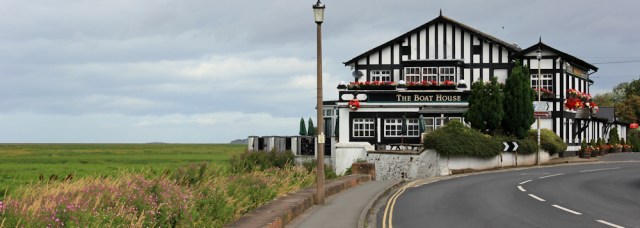
The main road curves away to the right, heading inland, while a track continues behind the pub and then follows the edge of marsh. A sign tells me I’m entering The Wirral Country Park, and mustn’t go faster than 10 mph. That’s easy!
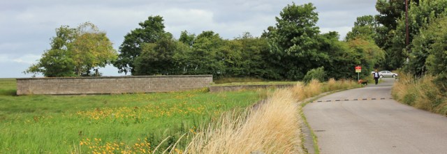
This turns out to be a very pleasant walk. There are a number of parking spots and an intermittent ‘sea’ wall (you can see a section in the photograph below), while the path is firm and clear. I meet a few strollers and dog walkers.
The footpath follows the line of what would have been the coast, but the water is now a thin line on the horizon, and the waves have been replaced by a green expanse of reeds and grasses.

I come across a bench. ‘IT’S DEFINITELY BRIGHTENING UP’ is the optimistic forecast etched on the side of the seat. But, no, unfortunately, it’s not today.

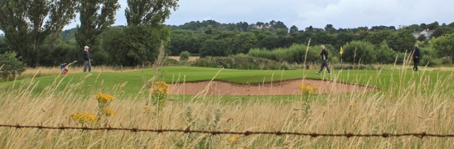
I walk past a golf course…
… and then reach a section with an isolated feel. There is a clear path, but it’s fast disappearing as overhanging bushes and thrusting plants attempt to reclaim it.

I come to a street, which stops in a dead-end on the edge of the marsh. Gayton Cottage, says my OS map. I use a handy wall to take a self-portrait.

And, in the distance across the water, a rare spot of sunlight is lighting up the far shore of the Dee, and I can see the white shape of a boat. I take a photo with my camera on full zoom. It’s the Duke of Lancaster!

The official footpath seems to come to an end at this point, but I can see a track through the grasses where others have walked, continuing onwards along the edge of the marsh. So I decide to follow it.
It’s easy at first, but becomes increasingly overgrown and, in places, very boggy underfoot.

I’m no longer walking on the ‘shore’ but in the marsh itself. It’s hard work and I’m not sure how far I can get, so I’m relieved to come across a set of railings leading upwards. Yet again, this place seems surreal – looking just like a seaside slipway or walkway down to the beach. I guess that’s exactly what it used to be.

For a short distance a footpath runs along the edge of the high ground, but then disappears. More steps lead me back down into the bog. I try to find a way forward, but it’s very overgrown and the sky above has turned black. Is it going to rain? It will be unpleasant to force a way through dripping reeds in a rain-sodden swamp.
So, reluctantly, I turn back. Close to where the steps brought me down is another dead-end street. I head inland towards the bus station.

It was a very short walk today, because later I’m doing a photo shoot for BBC Countryfile Magazine, who are going to publish an article about my walking trek. They want to photograph me walking on Ynys Llanddwyn. and so I have to travel back to Anglesey this afternoon. Looking forward to seeing the beautiful island again.
Miles today = another miserable distance = 4 miles
Total distance = 2,594.5 miles
Route:


Any idea when your Countryfile Magazine item will be shown.
Not sure which month, but sometime this autumn. It’s going to be in a ‘Back to Nature’ special.
Keep us posted on that Ruth, hope it went well. Tricky sections on the Marsh beyond Cottage lane, you did really well to get through that Ruth. I really hope they sort a board walk out one day, it frustrates me every time I’m down there.
Agree, Di. It wouldn’t take much to create a board walk, or even just to cut a track through the reed beds. Then there would be a lovely coastal walk all around the Wirral.
Love the photo of the Boat House pub, it looks a really pretty building.
I’ll definitely be looking out for the magazine article, especially as your photo shoot was done at one of my favourite places 🙂
Shame it wasn’t lunch time, cos I would have loved to stop there for a drink and a meal.
What a strange place with grass instead of sea.
It was certainly weird. And I’ve discovered other places with a similar feel as I’ve trekked around Morecambe Bay. Grange-over-Sands, for example, no longer has any sands!
They’re reminders of the ever-changing nature of the coast.
Here’s a bit about the ‘sea wall’ you mentioned in Parkgate
http://neston.org.uk/local-history/a-history-of-parkgate/parkgate-old-baths/
Also High tide at Parkgate
http://www.aboutmyarea.co.uk/Cheshire/Neston/CH64/Neston-News-Archive/News-Archive:-2013/263729-A-Very-High-Tide-in-Parkgate-Little-Neston-and-Burton
Wow, thank you Karl. Great links. The images of the storm surge were very impressive and what a dramatic change! The sea looked angry and hungry…. rather scary. Thanks for posting.
Great to get that view of the Duke of Lancaster!