
When I arrive at Knott End-on-Sea, the tide is low and the ferry over to Fleetwood isn’t running yet. I could just set off walking from here, but I want to take the ferry to Fleetwood and back, in order to keep the circuit of my walk complete.

The bus from Cockerham to Knott End-on-Sea was an infrequent and subsidised service, with only one other passenger on board, an elderly gentleman with a small dog. He told me he once lived in Knott End, and has travelled back from the southeast to visit old haunts.
Amazingly, he made the journey up to Lancashire along canals in a narrow boat. (Later I wonder how he managed the locks on his own, because he looked about 80 years old.)
I join my new friend in the Knott End Café, and have an excellent mug of coffee (no instant muck this time!) Then it’s down the slipway to wait for the ferry.
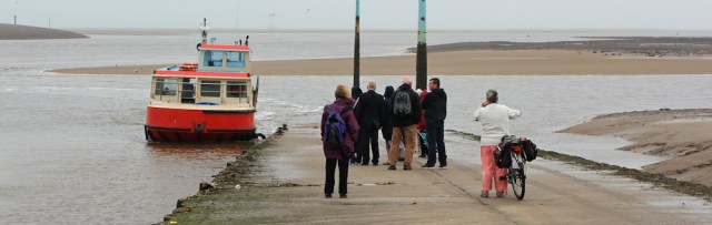
Our embarkation is delayed because the ferry crew must first clean the slipway with a high-pressure hose. Health and safety. The amusing thing is that we all have to walk back up the slippery slope, in order for them to clean it.
The crossing doesn’t take long. I amble around Fleetwood for a few minutes – feeling rather sad and lonely, because the last time I was here was with my daughter and her husband. Then I notice the ferry crew are untying the mooring ropes, so I hurry back and catch the same ferry back over to Knott End.
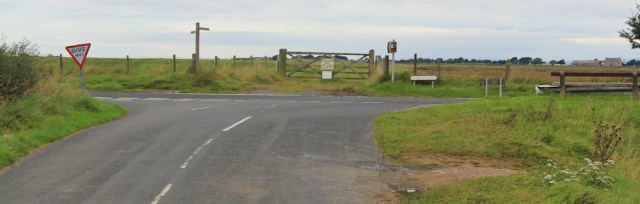
Knott End-on-Sea is another one of those places that probably once was a seaside resort, but now overlooks a marsh.
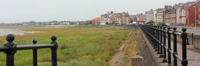
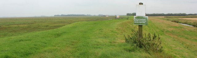
The walk gets off to a good start, following a tarmac track along the top of the esplanade and then along the marsh bank.
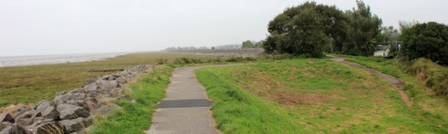
Unfortunately it’s a gloomy day, with spit-spots of rain falling from time to time. The horizon is obscured by murky clouds. So the views aren’t exactly spectacular. With little opportunity to take good photographs, I make rapid progress.

Unfortunately the footpath along the bank comes to an end after about 4 miles, and the Lancashire Coastal Way turns inland and follows the road. I’m fretting about this inland diversion when…
… I spot a sign telling me there is a permissive footpath along the bank after all! Yippee.

After crossing a couple of fields, I’m back where I want to be, on the raised bank. A sign tells me there is no public access between Boxing Day and Good Friday. Because of wildfowl shooting, I presume.
In my excitement at finding this alternative route, I ignore the first set of warning signs I come across on a gate. But I can’t miss the second set.
‘Warning. Construction site. No unauthorised persons allowed beyond this point.’

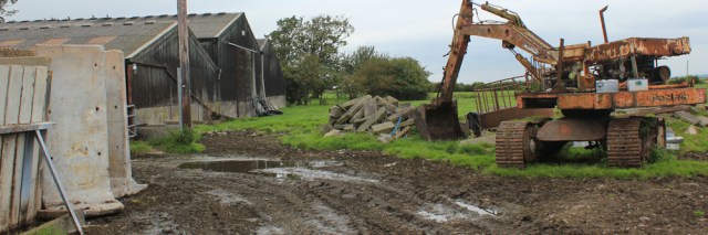
And ahead, on the bank, are diggers and other machinery. But I notice nothing is moving. Perhaps I should ignore the sign and carry on?
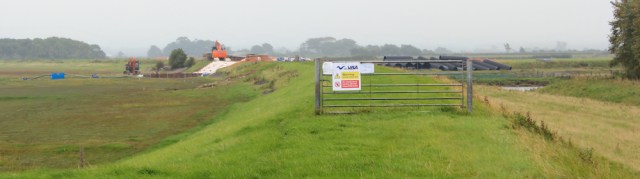
I hesitate. But I’ve already spent about a mile of ‘wasted’ walking. If I continue further, and still have to turn back, it will be even more frustrating. Sadly, I decide to retrace my steps.
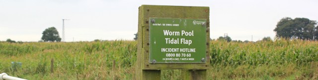
On my way back to the road I notice a sign. Worm Pool Tidal Flap.
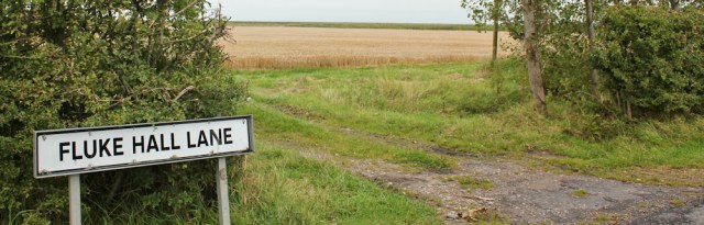
And, when I rejoin the road, I come across a street sign. Fluke Hall Lane. They seem to have a thing for intestinal parasites around here!
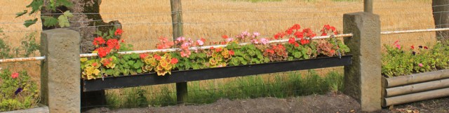
I walk through the outskirts of a village called Pilling, where the streets are lined by tubs of flowers. Very pretty.
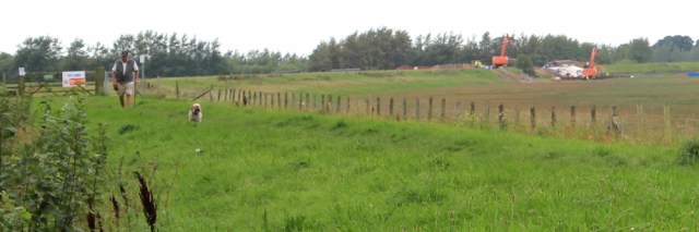
Over a bridge, and the road takes me past fields, across which I can see the bank and the point where the diggers interrupted my progress. Now the machines are actually moving, I can see men in hi-vis jackets. Perhaps it’s a good job I didn’t try to cross the construction site, after all.

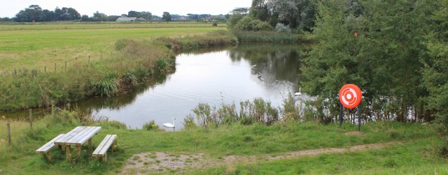
Ahead is a copse of trees, marked on my map with signs that indicate a parking place, a picnic bench, and a scenic viewpoint. It’s labelled ‘Lane Ends Amenity Area’ – a rather unromantic name, I think. Anyway, I’m looking forward to getting there because it’s where I plan to stop for lunch.

At the Amenity Area, I follow the track until it ends in a small car park on the raised bank. I can see the section further along where the diggers are working.
As I’m eating my snack lunch, an elderly gentleman climbs out of a little van and takes his dog for a walk along the bank. I know he won’t get far, because of the construction work. Sure enough, he soon turns back. The dog comes hurtling along ahead of him and hurls itself into the van.
He stops for a chat, and explains the dog heard the sound of shooting and that’s why she returned at such a pace and leapt into the van. Frightened!
We discuss the frustration of the closed path, and he tells me they’re trying to improve the drainage system because of the recent flooding in Lancashire. He asks where I’m heading and tells me to look out for Cockersand Abbey, which lies across the bay, and which I should pass tomorrow. He says the power station I can dimly see over the water is at Heysham, not Barrow-in-Furness (something several visitors to this blog have already pointed out!)
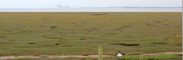
Also out there, somewhere, is Plover Scar lighthouse. We peer out into the gloom, but neither of us can spot it. He tells me it was rammed by a boat recently and was badly damaged. Perhaps it has fallen down?
I ask him if I can continue walking towards Cockerham along the raised bank, but he isn’t sure if there is a through route. Later, I look along the bank. A sign by the gate has disappeared. There’s a smaller sign warning about keeping dogs on a lead, so people must indeed walk along the bank. But will it come to a dead-end?
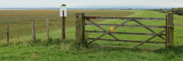
I dither for a while, but don’t want any more miles of wasted walking, so I head back to rejoin the official Lancashire Coastal Way, which follows the road.
Lane Ends Amenity Area may not have much of a view today – due to the gloomy weather – but it is a pretty place, with a small lake, swans, and more picnic benches.
Back on the road, I have another decision to make. Do I follow the main road (the A 588), which runs closer to the water? Or the official route of the Lancashire Coastal Way, which takes an inland diversion?
The sight of a constant line of speeding traffic along the A588, and the lack of a pavement, means I soon make my mind up. I have my rules to guide me. Avoiding death is more important than sticking close to the water. I’m heading inland.
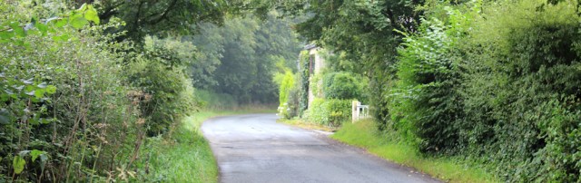
First I must walk along the A588 for a short distance. An unpleasant experience. Soon I turn off down a quiet road…

… and I’m pleased to reach a footpath, striking off to my left through a farm. But I have to wait while the farmer, who appears to be a woman, ushers a herd of cattle into a barn. She has a number of people helping her, all of whom are also women.
When they’ve finished, I ask where the footpath runs. One of the young women is delegated to show me the route. She takes me through the mucky farmyard and, for the first time today, I get my boots dirty.
Then she points the way forward, where the footpath apparently runs across the field, and tells me how I must follow the ditch, and then turn left, and then head for the red house.
This is all very helpful and friendly. But, WHERE ARE THE FOOTPATH SIGNS? Luckily for me, there was someone here to help. Otherwise, as walker, you would have no idea of where to go.
I walk through the fields as directed, over a stile, and along the edge of another field towards the red house.
Now where? I walk around the corner of the field and along the far hedge, before pulling out my map and checking my Garmin. I must have missed the exit. I turn back.
There it is. I finally see the yellow footpath arrow on a stile, barely visible because of the overgrown hedge and the tall weeds in front. Can you spot it?
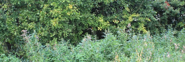
I’ll give you a clue. It’s in the dead centre of the photograph above.
The stile is rotten and, in trying to reach it, I nearly fall into a hidden ditch. A piece of plastic sheeting turns the bank into a treacherous slide.
Once over the stile, I’m faced with hacking my way along an overgrown bank, covered in nettles and thistles. It’s impossible to see the ground, which is not only potholed, but crumbling down into the dyke on the right. Very dangerous.
At the end of this difficult stretch, I squeeze past the side of a shed, past a garage and a rusty container crate, and face another obstacle course.
Yes, the footpath definitely runs here. No doubt about it. But clearly the occupier of the house think it’s OK to leave his mess obstructing the path. (You may have gathered, I’m quite angry now.). It looks like a rubbish dump.
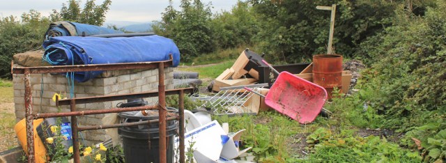
The footpath sign at the end of the drive still stands. One finger points down the road. The other finger, the one that should have pointed down this path alongside the property, has mysteriously disappeared. Hmmphh!
I note there are several parked cars in front of the house. It is obviously occupied, and they’re not short of a bob or two.
In a bad mood now, I stomp off down the lane. Another footpath sign, this one still intact, affirms I’m on the right route.
And from here the going is straightforward, as the Lancashire Coastal Way sticks to quiet lanes. Tarmac is tough on the feet, but safer than clambering over rotten stiles and treacherous ditches.
Ahead are hills, hung heavy with clouds. The sun even manages a brief appearance, lighting up the fields and I feel my spirits lift. I pass neat farms and pastures full of horses.

Eventually, my quiet road rejoins the busy A588. The Lancashire Coastal Way continues straight ahead, but that will have to wait until tomorrow.
I turn right along the road, now called Marsh Lane. It’s a relief to find I can walk safely along a pavement from here into Cockerham, where I’ve parked my car.
[Later I report the obstructions I encountered – in great detail with maps – to the local authority, although I haven’t received either an acknowledgment or a reply.]
Walked today = 12.5 miles
Total distance around coast = 2,722.5 miles
Route:


Hi Ruth. A great pity you had a detour between Knott End and Cockerham but upon reading my blog for that day I noted that the coast was designated for ‘re-alignment’ so maybe the substantial sea wall that i walked in 2012 is no longer available. Actually I did a lot of that section not on the sea wall but off the bank along the top of the marsh itself, which was then quite dry and firm. You can see from the map on day 237 of my blog. I’m afraid you may have a long inland detour from Heston to Hall End and getting around Heysham Dock was very confusing.
John
Now I wonder if I could have made my way along the marsh? But the tide was coming in and the ground looked very boggy. And I’m not sure if I could have navigated over the ditch where the construction was going on. Sadly I’m discovering much of the Lancashire Coastal Way isn’t actually coastal at all!
I find it fascinating to follow your progress along the coast of England…quite an undertaking. (Suzanne)
Thank you Suzanne. It’s a work in progress 😀
Hi Ruth, no problems with construction area on the sea wall. I simply walked below the sea wall on the marsh side – as long as you don’t enter the site itself. You would not even know there was work going on when you walk below the opposite side of the wall. I also stayed below the sea wall all the way around until it joined up with the Lancs Coast path again on the A588. Just had to climb one gate and a barbed-wire fence.
BTW just this minute back from completing the section Ulverston to Askam, I bypased the Isle of Walney and will be back there again this Sunday to do a full cicruit of the Island.
I need to get braver, Alan. Wish I’d done that. The inland route was very disappointing.
The ‘fluke’ in Fluke Hall might refer to fish rather than intestinal parasites, but perhaps you knew that?
No, I didn’t know that. Interesting. I did think it was a vile name for a nice country lane 😀
Presumably you either have, or will soon, walk(ed) along the Kent estuary near Arnside. Occasionally you can still see fisherman walking barefoot in the river at low tide. The flatfish will have all congregated there and as the fisherman stand on the fish, they bend down, grasp the fish and then chuck them to an accomplice on the mud/sand. Fascinating to watch, but it doesn’t seem very sporting. Like shooting fish in a barrel?
Sounds like you caught the bus that ultimately makes it’s way around to Fleetwood (the one I used to bypass the ferry, because it had stopped for the day). Yes Knott-end-on-Marsh would be more appropriate name! I guess this marsh/grass must be expanded at a rapid rate. Even the current Ordnance Survey Map of the area shows the marsh does not begin until around Fluke Hall but as you found it starts before that. The Orrdnance SUrvey are normally very good at producing accurate maps.
I somehow missed that sign about the permissive path along the sea wall so I followed the roads into Pilling (which was where I ended one walk and started another). It was only when I got to Lane End I spotted the other end of the path – frustrating.
I did brave the A588 rather than the Lancashire Coastal Way. It was not as bad as I feared it wasn’t actually that busy and there was a verge for most of the way). It sounds like it was certainly easier than the inland route. There is not a lot to see of Cockersand Abbey (you’ve probably been there already) so I would not get too excited!
If you think the Lancashire Coastal Way is bad wait until you get to Cumbria and try and follow the “Cumbria Coastal Way”. Oddly it is not marked on the OS maps any longer (though it used to be, as it is on one of the older maps I have), perhaps they decided it was not good enough?
I was staying in Lancaster this time, so parked at Cockerham and caught the bus. The bus driver seemed quite surprised to have a passenger, as the bus was empty! The old man and his dog got on later.
Re the Cumbria Coastal Way: you’ve explained a mystery. My OS map doesn’t show it, but my husband’s older map does. So, yes, the path seems – literally – to have dropped off the map. What a shame.
Flukes are flatfish in Morecambe Bay, not intestinal parasites. Whether you’re wise to eat them, what with the pollution, is quite another matter.
Ah. Thank you. I’m afraid I know nothing much about fish but, sadly, rather a lot about intestinal parasites! I’m relieved to hear the street name wasn’t as sinister as I first thought.
“I need to get braver, Alan. Wish I’d done that. The inland route was very disappointing.” Gosh, Ruth, you’re already braver than me. I was shouted at by a farmer when I was 14 so maybe it scarred me! I’m going to try to be brave. After all, what can they do?
OS map: they show where the path is supposed to be, I think, but often it has vanished with lack of use.
I confess I’ve done a bit of trespassing in my time – usually along river or sea banks where there is no footpath. But, as yet, I’ve never been shouted at 😀
You may already have reached this or bypassed it but if not then have a look for Sambo’s Grave at Sunderland Point – https://en.wikipedia.org/wiki/Sambo%27s_Grave – but watch the tide or you could get cut off.
It will be one of the highlights on that stretch, Eunice. Thank you for the reminder.
The Ramblers Association has a very good “report that path problem form” on their website. Worth filling in as local authorities tend to ignore problem reports unless they are prodded.”
Hi John. I’ve downloaded the Ramblers Pathwatch app, which I hope will make reporting less painful. And I must report an update: I’ve just (this morning) had a response from the council. It’s only an acknowledgement of my complaint and, rather worryingly, only mentions a small bit of the problem. Hey ho. At least I reported it.
Update: now a sequence of acknowledgement emails have arrived, breaking down the complaint into its component parts. Perhaps someone local will report (in a few months time) whether the problem has been fixed.
Good tip! I’ve got lost so many times due to lost or hidden signs.
Well worth doing.
Glad you reported those problems to the authorities Ruth. It only takes a few signs to be missing or hidden and it can be really difficult to find your way. Like you I usually walk alone and on many occasions I’ve felt anxiety getting the better of me when the lack adequate signage puts my navigation skills and nerves to the test.
Frustrating, isn’t it, you either end up climbing over gates and fences, or turning back.
Missing signs, hidden signs and blocked paths are the bane of my life. I don’t know why some landowners have to be so bloody minded. I can’t imagine a few walkers would cause them any problems.
It’s very annoying, isn’t it. I now try to report all the obstructions I come across, but it takes time and effort.
Ruth… how are you.. sorry to bother you..
trying to work out how practical this section is… seems very confused on maps and on the ground.. lots of private farm roads etc etc… any advice gratefully received,,,
Hi Paul. Yes, it’s a tricky area to naviagate. You should certainly be able to walk along the shore bank all the way to the amenity area, as I’m sure they will have finished rebuilding the sea defences by now. So no problem… until you reach the A588. That road is too busy to walk safely down, so I suggest you pick up Gulf Lane and follow some of the minor lanes a bit further inland. I wouldn’t bother with the footpaths – blocked or non-existent 😖 Would be interested to hear how you get on.
Well it sort of worked Ruth. The tidal flap is now passable. Still divers ther as of March 2018. The references to bulls and do not pass etc. Signs turned out to be more because of Morecambe Bay Wildfowl Association ponds for shooting geese.
however 2 miles from Cockerham we wow forced to take the A road by 30 cows on rhe tidal defences. a local told us sues quaintly at the excellent Manor Inn at Cockerham that that breed of cow is gentle… We always air on the side of caution though after a potentially dangerous run in with a bull on the cliffs of Gerrans Bay in Cornwall.
We saw signs later to the Lancashire cycle way. Looks very nice for your husband
All the best for your continued walking.. We are so grateful for your blogs. We little rally print them off and we know we are in the best of hands for the day ahead.
Glad you made it through. Shame about the cows!
Posting this info from Ian Chatfield here, as there’s an update on the state of the path and it looks like the Knotts End ferry might not be running 😖
***
Hi again Ruth. Just wanted to mention a couple of things as I did Cockerham to Knott End this week
Firstly – your correspondence with Lancs. County Council re the footpath. It has borne fruit â plenty of what look like new signs, no obstructions and MOST of the rubbish has disappeared.
However, whilst you had your personal guide through the farmyard I didn’t and could find no way through as it was obstructed by a fenced herd of cows at each end of the farmyard. The telegraph post clearly shows the path straight on. So I just climbed over a couple of fences and trespassed, hoping the farmer might see me and I could pass on my comments (robustly)
Secondly, you were lucky to use the Knott End ferry. It has closed! Not that you would know. There is absolutely no information on either side, I just had to ask someone. I thought Iâd try the web site, twitter, facebook but no information that it has closed or whether it is temporary or permanent. So Lancashire County Council , which provides financial support for this transport link, will be hearing from along with my comments to the footpaths officer.
Best wishes
Ian
thanks Ruth Apparently the ferry is all about money…Locals are very upset…
How are you getting on in Scotland? Isle of Arran posts looked beautiful
I’ve finished Arran now. Have a few days of walking to write up.
All that disgusting rubbish would make me fume. Behaviour like that is unacceptable.
I came across piles of rubbish in one of our New Forest car parks this week and this post has reminded me to report it.
Pingback: 10. Fleetwood to Glasson Dock – A 5000 mile walk