
It’s a long drive from Lincolnshire to Lancaster. My husband has come with me, and we eat a late lunch at the famous Snatchers Inn, otherwise known as the Golden Ball pub. The sun is shining when we arrive and we eat outside. But, by the time we’ve finished lunch, the weather has changed. Dull. Rain threatening.
I set off down the road. There are dairy cows in the fields and they look very skinny to me. Huge udders and ribs showing. Poor things.

But I don’t have to worry about cattle encounters, as I will be road walking for the next few miles.
My husband, meanwhile, drives to our prearranged meeting point and begins his cycle ride. (This is what we do when he joins me on one of my walking expeditions: he cycles while I walk, and we meet at the end of the day.)
Today I meet him prematurely, as I haven’t got very far when I see him cycling towards me. Time for a quick photograph…
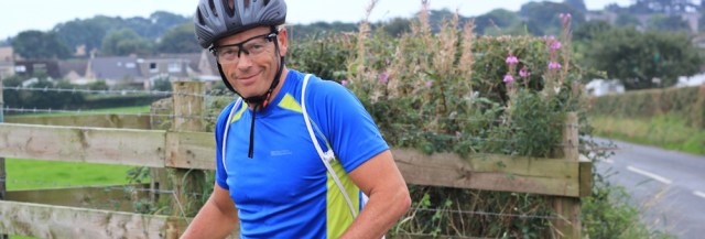
… and then we’re off again. He continues cycling towards Lancaster to pick up route 69, whose praises I’ve been singing. I carry on along the road to Overton.

In Overton I manage to get lost, and miss the footpath that would take me round Bazil Point (I can’t think of that name without hearing Sybil Fawlty’s voice in my head. ‘Basil!’) Anyway, by the time I discover my mistake, I’ve reached the end of the village. There doesn’t seem much point in turning back.
The next section of road will take me through Lades Marsh to Sunderland Point. I’ve already been warned by several other coastal walkers: this is a tidal road. Alan Palin hiked along here recently and only just beat the incoming waters!

The light is really dull now and I struggle to take any decent photographs. Not only is the light terrible, but I’m using a not-very-good lens on my camera because my favourite landscape lens is jammed with Blackpool sand and I have been unable to clear it.
I come across some ‘Road Closed’ signs. Oh dear. That’s worrying. But I ignore them and carry on.
Then there’s another sign. ‘DANGER. Do not proceed when these post are in water.’ This sign, luckily, is standing high and dry at the moment. Onwards.

I meet a couple of walkers hurrying towards me. ‘We’re trying to beat the rain,’ they tell me. I ask if the road ahead is really closed, and they tell me it’s not.
Further along, and I come across a gang clearing a drainage ditch. This is the reason, I presume for the road closed signs. In fact, a little red car is coming through, and the tractor has to move to let it pass.
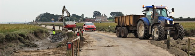
There is only road to Sunderland Point and this is it. So, I guess, they can never really ‘close’ it. Perhaps the ‘Road Closed’ signs are there to deter casual sightseers?
The marsh is awe-inspiring, with deep gullies running through vast tracts of mud and grass. Difficult to believe it’s all covered at high tide. The water seems far away on my left at the moment. In fact, this is the mouth of the River Lune and that’s Glasson Dock on the other side.
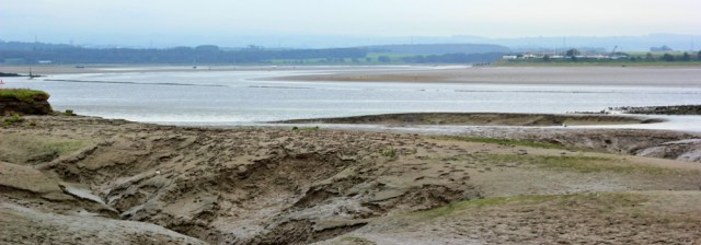
Shame about the terrible light, making photography almost impossible.
I meet another walker coming towards me. This lens is better for portraits, but hopeless for landscapes.

And then I walk onwards to Sunderland, a tiny place with a row of houses, a narrow beach, and an information board. The board tells me how to find Sambo’s grave, a well-known local memorial – which lies on the other side of the point. I mustn’t miss it.
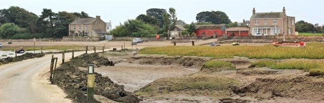
Sunderland looks rather appealing, despite the dismal weather. What is it like to live here? It must feel like an island when the tide is high, and I wonder if the houses are flooded by storm surges in the winter.

At this point it begins to rain. I stop to pull on my mac and tuck my rucksack into its waterproof cover.
I think it might be possible to walk all the way around Sunderland Point by way of the shore. But by now the rain is lashing in, sideways, from the sea, and so I take the easier option and use the footpath that cuts across the tip of the point. At least it’s sheltered under the overhang of trees.

I soon reach the west side of the point. There’s a gravel track running along the bottom of a raised bank, and the low-lying ground is covered in marsh grass and large pieces of driftwood. Out there is a tower. Ah. It’s my old friend, the slightly-damaged Plover Scar Lighthouse.

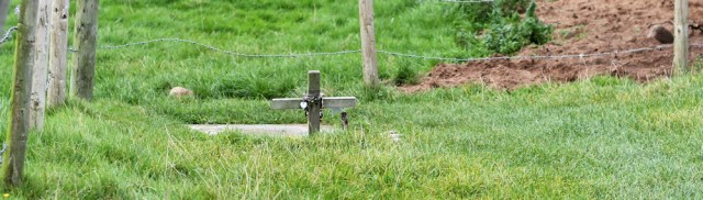
I turn left and look for Sambo’s Grave, soon spotting a rather homemade sign in the hedge.

On a small piece of fenced land, just on the other side of the hedge, is a tiny cross. It’s very small and insignificant looking. Very poignant.
When I walk around the cross, I’m surprised to see an extensive collection of tributes – everything from painted stones to plastic teddy bears. I don’t know whether to be heartened or horrified. It seems tacky at first glance, but then I think of the impact this one death had, and how people are still touched by the young lad’s story.
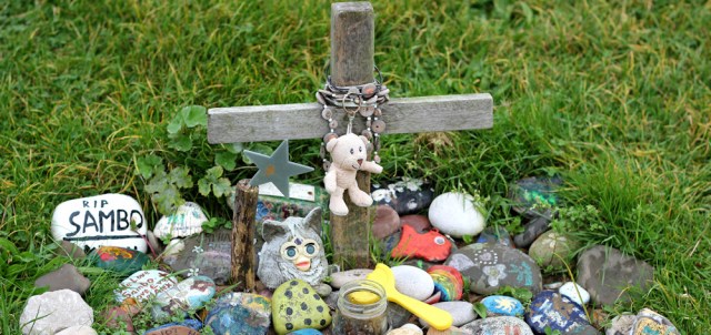
It stops raining for long enough to take a few photographs, first of Sambo’s burial site, and later of the marsh. Yes, those are cattle in the distance, but none of them come close to the path.

A few minutes later the rain comes pelting down again. I stow my camera away, put my head down, and walk onwards. There is no more photography today.
It’s just over a mile to the meeting place where our car is parked and where I’ve arranged to meet my husband. By the time I get there I am absolutely soaking wet. Hubby hasn’t arrived yet, but the car is a warm oasis of dryness – and I’m very glad I had the foresight to carry a spare key with me.
You can learn more about Sambo (or Samboo) on the Friends of Sunderland Point website.
Walked today = 6 miles
Total distance around coast = 2,748.5 miles
Route:


My brother lives just east of Lancaster so I know that part of the country quite well. It generally dull grey and damp up there! I’m on page 176 of your book, chapter on personal safety! Looks like I need to buy a lot of gear and maps and general stuff before I venture out for real, but maybe I’m using that more of an excuse. Actually I’m getting excited with the challenge of the walk ahead!! your idea of parking the car and taking a bus to a start point, is a great idea. Gives you a goal and a way home at the end of the day!
Hi Chris. Yes, unfortunately the weather is very dodgy on the west coast! Please don’t be put off walking by the information in the book. Really you just need a good pair of walking shoes/boots and a charged phone, but it does help if you have walking clothes too and know a little about map reading. And, when you get going with your walk, please keep us informed of your progress. Best wishes. 😀
Pleased to see you didn’t get stranded Ruth. My gran used to live at Overton back in the 1970’s xx
I took your advice and read the tide tables before I set off, Lynne. I wonder if I passed your gran’s old house?!
I’m glad you found Sambo’s grave; I think it’s rather sweet that people still leave tributes there. Glad too, that you didn’t get cut off by the tide.
Yes, it is rather nice that they do. Poor little lad, though. There are some shameful things in our national history and slavery is one of them.
Hi Ruth, I had exactly the same thought when I walked out to Bazil Point! That is Sybil’s shreaking “BAZIL!”
Only the left hand post was covered in water when I hurried through, I proceeded because it did say “posts”, I still cut it fine though.
On the Scotland front, 2 more days this weekend will take me to Greenock and the River Clyde.
Ha ha! I thought it was just me with the ‘Bazil’ problem 😀
Wow, you’re making great progress. I still have vague hopes of reaching the Scottish border before the end of this year. But I guess it all depends on the weather. Fingers crossed.
I read the link on Sambo – that is a really touching story.
Yes, such a sad story, Anabel. I’m glad I found the grave.
I rather enjoyed this walk and I was also thinking of Syball Fawlty as I was walking past Bazil Point. The footpath around that was difficult through bog/marsh with lots of debris washed up so whilst the views were quite nice the terrain was not so good. Sunderland Point is an interesting place walking out along that muddy road. You can make it round Sunderland Point on the beach but it is not that easy and seems to be discouraged (there was a fence stretching most of the way out the beach at one point). But faced with the weather you had I would have picked your route too!
I’m glad I didn’t try to make it round the point. And, isn’t it funny how we all have the same mental flashback when we see the word Bazil or Basil. I guess no sane parent would give a child that name now!
IM GLad you got through in one piece, if rather wet. The story of Sambo’s grave was lovely.
It was a sad story but ultimately uplifting. Glad I visited it.
The tale of Sambo is sad but it’s moving that local people still remember him and leave tributes.