
It’s early November and, after a few days of rain, an optimistic weather forecast has brought me back to Cumbria. My husband drops me off at Broughton in Furness, or – to be more accurate – beside the now-closed pub at High Cross on the A593 / A595 junction.
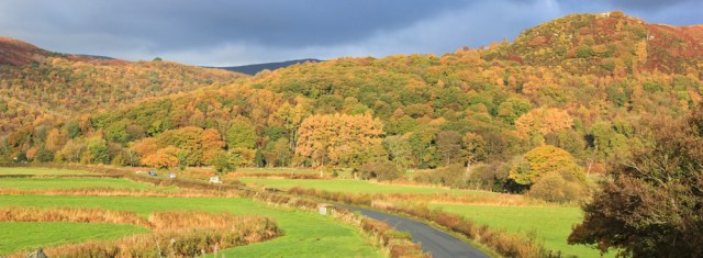
The road to Duddon Bridge curves ahead. It’s been an extraordinarily mild and calm October, and the leaves haven’t yet fallen from the trees. The autumn colours are glorious.
It’s one of those days where my route must be cobbled together, a mix of road-walking and footpaths. Will the roads be safe? Will the footpaths be passable? I’m not sure.
The pavement along the A595 soon comes to an end, but an alternative route is provided for walkers via a footpath across fields and then along the river bank. This should take me right up to Duddon Bridge.

The fields are muddy and I’m glad I’m wearing my most waterproof boots – my heavy, leather clodhoppers. (In a short while, I won’t be quite so happy with my choice of boots, but, for now, they’re fine.)
I reach the bridge and climb up the bank to rejoin the road.
Duddon Bridge is old, narrow, and has a treacherous approach via a blind bend. Traffic is heavy – a lethal mix of speeding cars and lumbering lorries. Luckily, the bend slows down the flow of vehicles, and the bridge is controlled by lights, creating a one-way system. I cross safely.
This bridge marks the apex of my trek up the Duddon Estuary. From here I’m heading downstream towards Millom and the sea. The riverbank on this side is not marked as a public footpath, but I was half hoping I could walk along it anyway… plan A.
Although a gate guards access to the bank, its padlock has been left open. Excellent! But the thick chain, private signs, and barbed wire make me hesitate.

I don’t mind trespassing, but my map shows it’s a couple of miles before I reach a stretch of bank with a proper public footpath. What other barriers might I face? Would I be forced to turn back? After dithering, I decide to go with Plan B, and follow the road instead.
But the traffic hurtling along the road proves even more intimidating. Time for Plan C.
I turn right along a little lane leading off the main road, where a tiny collection of houses hide among greenery on the lower slopes of Wrayslack hill. From here a footpath runs on the slope above, and parallel to, the busy road.
But first I have to find the path. I find a green lane going uphill…

… and then join what appears to be a private drive, before eventually finding the continuation of the footpath. It’s tucked away down another driveway.
Plan C turns out to be a great idea. The path looks as if it was once an old road, with a surface of cobbles and stones, and it leads up through an area of unspoilt woodland – Stanley Wood.

Unfortunately, the combination of leaf litter lying on wet stones creates a treacherous surface. My clodhopping boots slip and slide like a pair of ice skates. Thank goodness I’ve brought my poles.
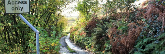
All too soon I must turn down the hill. A handmade sign warns me: ‘Public Right of Way, leads directly onto a busy Main Road’. Sigh. I know. And I would much prefer to stay among the trees. But I have to get back to the shore.

Soon I come out of the wood, just above a house with a water wheel, and am treated to a glorious view across the valley. I stop for photographs. Such a stunning display of light and colour.

The path, as warned, does lead directly onto the main road. The morning flurry of rush-hour traffic has abated, but I’m still buffeted by fast and furious drivers.
I stumble along the verge for what seems like ages, but in reality is only a hundred yards, before I find what I’m looking for. A quiet lane leading down towards a place called Lady Hall.
At this point, this lane is the closest I can get to the estuary, legally. It’s a pleasant walk. The only traffic I meet is a couple of cyclists (who clatter past me, bells tinkling, as they hurtle downhill), and a cautious woman driver who seems barely able to see over the steering wheel of her enormous 4×4.
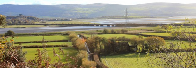
Just above Lady Hall, I get a great view of the Duddon Estuary and the Duddon Viaduct. The track below – still glistening from the overnight rain – will take me down to the bank.
Soon I’m back by the water… or, should I say, back by the edge of the marsh, because there’s no sign of any actual water at the moment.
Looking northward and up the valley, I can see a clear well-trodden path along the top of the bank. Drat! Perhaps I could have walked here along the bank all the way from Duddon Bridge after all? Oh well, too late now.
The storm clouds over the Lakeland hills look worrying. My husband is up there, somewhere, on his bicycle. Hope he is alright.
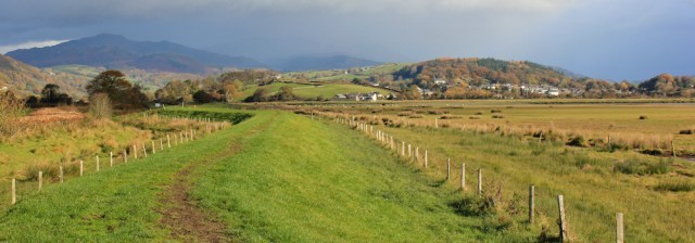
I turn southwards. The bank stretches ahead, curving gradually, dividing fields on the right from marsh on the left. This isn’t actually public footpath either, but I’m hoping the route ahead will be clear of barriers. The sun shines low and in my eyes. Onwards.

Just inland from here is a long ridge of high ground. Is that Black Combe? It was a dominating feature during my walk around the north side of Walney Island. And feels like meeting an old friend.

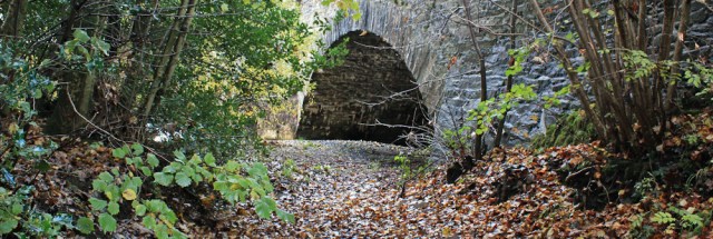
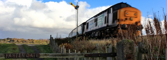
After a very short distance, my path along the bank is interrupted by the railway line. Duddon Viaduct is only a stone’s throw away. I wish walkers were allowed along it, as well as trains!
Right on cue, a train thunders by.
I needn’t have worried about obstructions. All the gates I meet are closed, but unlocked. And there is a safe crossing place over the railway line.
I’m on a genuine public footpath now. Onwards, along the bank. Into the sun.

To my left, across the marsh, a streak of water marks the estuary, and beyond that is a collection of houses. I check my map. Yes, that’s Skellow Crag End, on the edge of Foxfield, the route of my previous walk a week ago.

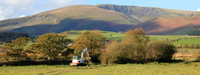
To my right, a digger is excavating a ditch. Probably a farmer trying to improve the drainage to his fields. And behind that is a wonderful view of Black Combe.
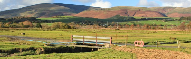
I meet Black Beck, a tributary stream that empties into the estuary, and here I am anticipating an inland deviation, because the map shows the footpath turning away from the bank. But, instead, I find I can cross over the beck via a sturdy bridge and continue along what looks like a service track for local farmers.
The track ends near Green Road Station – a very weird place for a station because it seems to be in the middle of nowhere. (For this reason, it reminds me of the Severn Tunnel Junction in South Wales, another station with no visible village to support it.)
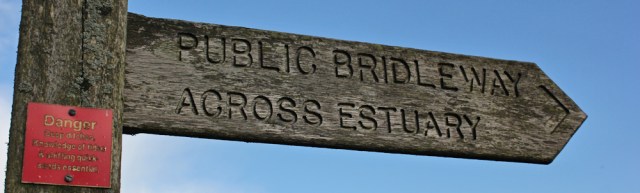
Turning left, I head back towards the bank of the estuary. Here a finger-post says I can follow a public bridleway and continues straight on, all the way across the estuary, to Sand Side on the opposite bank. A much-too-small warning sign, placed too high on the post to read comfortably, suggests this would NOT be a good idea.
‘DANGER. Deep ditches. Knowledge of tides & shifting quick sands essential.’
Another sign, a little further down the post and easier to read on a green background, but still much-too-small, tells me ‘THIS ROUTE HAS NATURAL HAZARDS’. And suggests I ‘SEEK LOCAL GUIDANCE.’
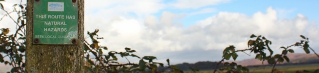
Still further down, somebody else has simply carved six letters – D A N G E R – into the post.
Of course, I have no intention of following the bridleway across the estuary, which in any case would lead me back to where I was a couple of walking-days away, and not where I want to be.
I look in the direction indicated by the finger-post, I can’t see anything other than marsh and bog. It looks both forbidding and wildly enticing – both at the same time. Does anybody actually use this crossing?

It’s nearly 1pm. A handy stile seems a good place to sit down for a rest and a snack.
[to be continued…]


Fab photos, I assume you’ll be adding the write-up later? 🙂
Yes, Eunice. Apologies. Hit the wrong button – meant to [save] not [publish] 😀
Glad you back on the trail – possibly Scotland by year’s end! Wrap up warm…
Best wishes,
Gemma.
Definitely Scotland soon. But this might be the last trip this year. I’m only a fair-weather walker, I’m afraid.
Can’t wait for Scotland though. Don’t know whether you know Scotland already Ruth but some of those beaches high up on the west coast will blow you away ( haha quire literally too with some of the winds up there) Caribbean like white sands and turquoise sea. Breathtaking.
I’m looking forward to it, Di, and it’s not an area I know at all. Sounds wonderful.
Lots of kisses on this one. (I assume that’s what the XXX’s are for? :-))
Ha, ha. Kisses? Or Word Press censoring my language? No, I’m afraid just hit the wrong button last night!
Ruth it looks gorgeous!!!! Is that why you’ve put the kisses? Colours are stunning. I’m so jealous !! 😊Script coming later ? Great to see you back on the trail, I really miss your blog when you have to go home. Doesn’t it worry you walking in the winter with the shorter days? I always worry about getting lost when darkness is setting in.
Hi Diane. This walk was completed in early November – been late writing it up for various reasons. It was an absolutely fabulously gorgeous day, and I had my new camera lens. Hard to take bad photos in such circumstances.
I’m afraid, as you guessed, the kisses were a complete accident!
Gorgeous pictures – which I suspect might have published prematurely!
You guessed right, Anabel. Apologies. Not the first time I’ve published what appears to be an xxx rated post, I’m afraid! I like to put the photos in first, and then write the text. But I really must remember to push the [save] button, not the [publish] one!
Easily done!
And I’ve now been back and read the words.
Your photo from above the watermill is spectacular – it is unusual to have both the light and the colours in autumn. Not many leaves left now. Sue
It was just one of those staggeringly beautiful autumn days. Best wishes.
I missed all the fun – kisses etc and photos without text, ha ha.
“a train thunders by” you aren’t a railway enthusiast then? That’s not just a train it’s a proper locomotive, maybe a Class 46. I’d guess at least 40yrs old. Some of my canal walks loosely follow railway lines but most trains are commuter units and not terribly interesting.
Delighted to have you back after a bit of a gap in posts.
Yes, you missed the xxx rated post! As for trains, I like them. They get me from A to B and are the best way to travel. But I’m ashamed to say I don’t know much about them 😀
It’s a class 37. They “top and tail” a few coaches and run between Barrow and Carlisle.
Thanks Barry. I guess from now on I need to pay a bit more attention to those trains 😄
thanks for correcting me Barry. They are pretty old, aren’t they?
They were built between 1960 and 1965, originally 400 of them. They are remarkable survivors. A number are owned by Direct Rail Services and operate nuclear waste trains to and from Sellafield, some are leased to the local rail company which is what the one photographed by Ruth is doing. I suppose I ought to get out more!
Thank you Barry. From now on, I’m going to pay more attention to train engines! Lots of interesting history wrapped up in the railways.
I’m glad it’s not just me who accidentally presses post when they meant to press save. Also interesting that your writing process is a lot like mine. I always like to have the photos uploaded first too. Surprising how many odd little things they help me remember.
Great minds work alike, Marie. It did generate a lot of interest among my regular readers though, when I published an xxx rated post 😀
Glorious autumnal colours though that sky over the hills looked menacing.
285 Broughton to Haverigg. Mention of the Duddon Estuary (unknown to me) in Caravan and Motorhome Club mag, prompted me to ‘input a search’. What a delightful result! I really enjoyed your account of your walk here with its lovely photos.
Thank you Paul. Best wishes, Ruth