
I catch the train to St Bees, an ancient village and once the site of a Norman Priory dedicated to Saint Bega, from where it gets its name. I pass her statue (I think) on the bridge as I walk towards the coast.
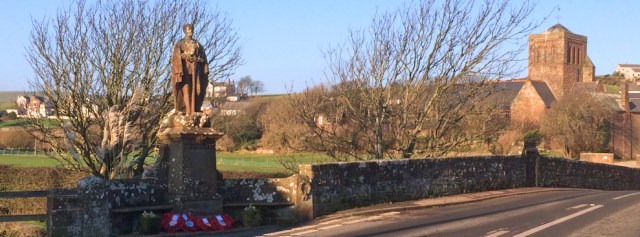
[Later I learn the statue is St George, not St Bees, after all!]
In my hurry to leave this morning (I spent too long chatting over breakfast) I forgot to bring my camera. Oh dear! Too late. I shall have to make do with my iPhone.
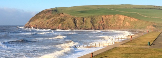
When I get to the shore the tide is high and the beach looks very different to yesterday. Now the sand is covered and the waves, whipped up by yesterday’s wind, are foaming against the wooden breakwaters.

The weather has brightened. The mist has gone. And St Bees Head is radiant in the morning sunshine.
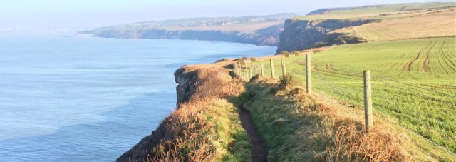
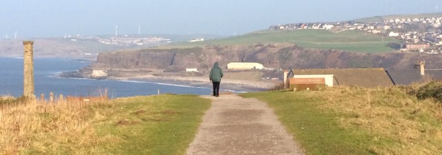
I set off along the coastal path and turn to take a photograph of St Bees below me. Unfortunately, the coast is dominated by the static caravan park. I’m sure it’s a great place to take a holiday, but it rather spoils this very attractive part of the coast.

St Bees Head rises to 110 metres above sea level. Not very high really, but the first significant climb I’ve done in a long time.

At the top I decide it’s time to take a self-portrait. With my Canon, I must set the timer, balance the camera on a rock, and run backwards to get myself into a suitable position. My iPhone might not be good at landscape views, but it does take a great selfie!

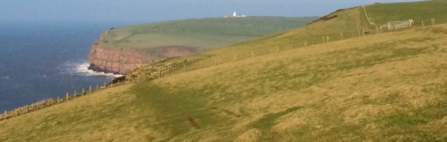
Onwards across the cliffs. In the distance I can see the lighthouse.
It’s actually a pretty easy walk, once you’re up on the Head. There’s only one significant dip down into a gully called Fleswick. It’s also a well-trodden path, although today I don’t meet anybody else up here.
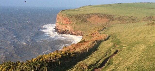
The cliffs here are famous for their seabirds, and the RSPB provides a number of handy platforms and viewing areas, with railings to keep you safe from falling. I don’t spot much in the way of bird life (January is probably the wrong time of year) but I do manage to take a shadow selfie!

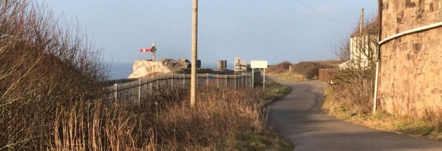
When I reach the area with the lighthouse, I discover the white tower closest to the sea is actually a watch tower. I can’t see anybody ‘watching’ today, so not sure how often it is in use.

The lighthouse is perched on top of a slope. From the path I can just see it peeking over the ridge, but I’m too lazy to climb the hill for a better look!

I round the headland – North Head according to my map – and now I can see all the way to… well, I think Whitehaven is tucked away just out of sight in the next bay.
It’s easy walking. Fields to my right. A clear path. Relatively flat.
Then I come to a working quarry, Birkhams Quarry, where they excavate lovely red sandstone. I’m surprised to see diggers and trucks out working. My OS map mentions quarries, but marks them all as being disused.
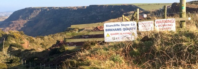
The footpath curves around the seaward side of the quarry, where an information board tells me the stone from here was used to build:
- Victoria and Albert Museum in London
- Liverpool Cathedral
- Carlisle Cathedral
- and several buildings in Hong Kong and Canada.
It’s great to see a board giving details of local industry. I pass a lot of industrial sites on my way around the coast, and often have to guess (or Google) to discover what’s going on.
I come across a finger-post. Ah. I’ve unknowingly followed part of the Coast-to-Coast path, Wainwright’s famous long-distance trail. One of the gentlemen in the B&B was talking about trekking this path over breakfast.

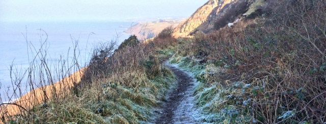
But I’m not continuing along the Coast-to-Coast route. Instead I stick close to the sea, and begin the descent towards Whitehaven. The path lies in the shadow of the cliffs and the ground is still frozen. I don’t mind, and decide walking on frost is better than wading through mud.
I arrive on the outskirts of Whitehaven. This is Saltom Bay and the landscape is dotted with the remains of old industry. The building below reminds me of Cornwall and the ‘Poldark’ mines.

Saltom Pit was a working coalmine in the 18th and 19th centuries, and the tunnels stretched out for 2km under the sea. Now all that remains are some ruins, an old pit shaft wheel, and a dangerously unstable cliff.
My B&B landlord tells me they are planning to reopen the mine shortly. Apparently a seam of very high quality coal extends under the sea and is financially viable to extract.
Onwards, and I start to meet people. Strollers and dog walkers. And now I’m nearly in Whitehaven.
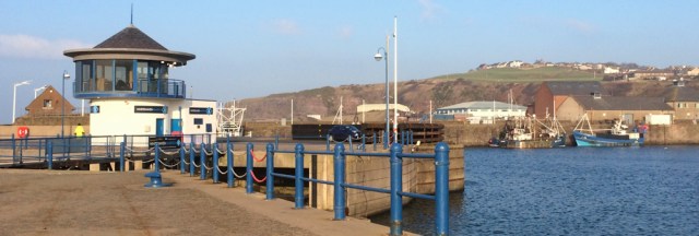
I come to the brow of a hill and see Whitehaven spread out below. It really does look very attractive in the sunlight. I didn’t expect to find such a large harbour, or a marina full of ships.
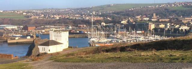
The old harbour walls provide calm anchorage, and two light houses mark the entrance. I manage, inadvertently, to take another shadow selfie (bottom right of the photo below!)

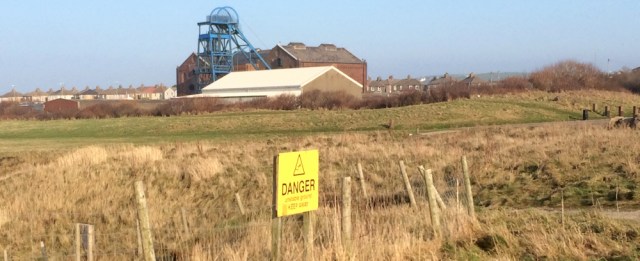
A tall tower (shown two photos above, and called The Candlestick) is actually an old ventilation shaft for the Wellington Pit. This mine closed in the 1930s and sounds a terrible place to have worked, mainly due to the large amounts of dangerous methane that caused frequent explosions and deaths.
A modern pavement mosaic commemorates the miners…
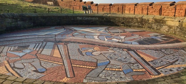
… while other paving slabs are engraved with various memories, including fascinating (and horrible) details of the dangerous lives of the miners. Two young boys are mentioned, both killed, both only eight years old. It’s unbearable to think about.

I leave the horrors of the mine behind, and walk down to the inner harbour. It’s large. Once bustling with ships carrying coal and other goods, now the port contains just a few working boats – and a lot of pleasure yachts.
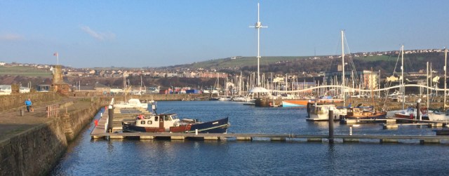
I walk around the outer perimeter of the harbour walls. It’s possible to get all the way around if the swing bridge is in the right position, which it is today.
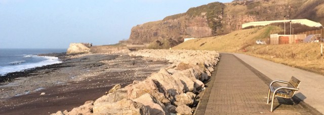
On the other side of the harbour, I make the mistake of heading off along a new-looking promenade. This is North Beach. But I soon realise I’ve reached a dead-end and must turn back.
Never mind. I sit on a handy bench and have a quick rest, a drink and a snack.
Then I walk back into Whitehaven. I could end my walk here, but it’s only early afternoon and I still feel full of energy, so decide to carry on to the next place where the train stops. A village with the odd name of Parton. (Dolly?)
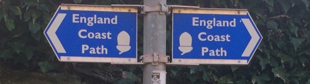
As I leave Whitehaven, I find my first ever England Coast Path sign.

When I first started my coastal walk, the England Coast Path was only a vague plan. Two years into my trek, and one short stretch near Weymouth had been completed. Several other pieces have been completed since, but the whole path is supposed to be in place by the end of 2020. Less than 4 years away. I don’t believe it will happen. But, despite my pessimism, it’s good to see a real, live, England Coast Path sign.
Not that the path is very exciting, I’m afraid. It’s a joint cycle-walking track, and I’m not even sure it’s new. Worse still, the path is on the wrong side of the railway line and not next to the sea.
Onwards. I pass more signs of old industry, and stop a man to ask him if he knows what these tunnels once were. Kilns? Storage chambers? Passages?

He doesn’t know, but he does point out a fenced off pit and tells me there’s a passage from here that leads under the railway line and emerges on North Beach. So I didn’t have to turn back after all?!
He also tells me it is possible to walk from Whitehaven to Parton along the shore, if the tide is out, because there is a stone ledge just below the railway line. But he tried it recently and it was too slippery. In fact, he fell over and got covered in slime, and had to return home to change his clothes. Maybe a good job I didn’t know about it was there and didn’t try it.
Further along, and another information board tells me that Parton was once a thriving place, a busy fishing port and a hive of other industries, such as tanneries.

Now it’s a very quiet place. Quiet – until I hit a button on the information board and a recorded voice starts telling me, very loudly, about the history of the area. It’s the same information as is written on the board. I hit another button to make it stop, but that just sets off another, and slightly different, recording.
Now, strangely embarrassed although there is nobody around, I feel duty bound to stand and listen until the recording stops. It seems to go on, and on, and on, and on…
When I reach Parton, the sun has disappeared behind clouds, and I can’t take a decent photo with my iPhone. So have to make do with another snap of an official England Coast Path sign.
Walked today = 10 miles (this distance is becoming a habit!)
Total around the coast = 2,951 miles
Route:


A fascinating walk and great photos without the mist. I like the pavement mosaic but the fate of the two young boys doesn’t bear thinking about. The recorded information board made me smile – if there was nobody else around I would have walked off and left it talking to itself 🙂
I laughed at that bit too, Eunice! Ruth, you are just so polite. Even to inanimate objects.
Hi Eunice and Annabel. It’s amazing what wonderful photos you can get with a simple iPhone, but I must say I do prefer my proper camera. And, you’re right, I should just have walked off and let the information board continue talking to itself… but it was that typical English-embarrassment thing taking hold of me!
Your photos are still good! The look-out tower is St Bees foghorn (NT) and was recently open to visitors for a weekend (according to Twitter!). Sue
Does the fog horn still work? Would love to hear it.
I don’t think it is used any more.
Hi Ruth,
Yes, it is great to see the England Coast Path signs start to pop up – I have seen them between South Shields(Marsden Bay) and Seaton Carew – and between Watchet and Steart – these were my first and very welcome and unexpected at the time and also popping up on Explorer Maps now.
It will be very interesting to see how it is routed in places – hopefully creating new paths and river crossings and linking up with other LDP’s.
Best wishes,
Gemma.
On my new OS map of this area, the England Coast Path section of the coast is shaded a rather pretty salmon-pink colour. Good to see it on the maps. I think the path needs a special logo though.
My impression is they’re creating the easy sections first. That’s one reason I’m pessimistic about it being finished on time,☹️
Wow! You’re making good progress….you’ll be in Scotland soon 🙂
Yes! Scotland here I come 🙂
Those voice boxes are awful. I’ve only come across one once. I saw the button and just had to push it. (The lettering on the sign had worn off) It nearly frightened the wits out of me as I was walking through a Kauri forest on a gloomy day!
😆 Yes, I can imagine it.
One of the late returners here after the Winter break. Looking forward to following your journey into Scotland.
Hi David. It’s good to be back on the coast again… and nearly in Scotland!
Pictures are great Ruth, great to see areas of coast I don’t know. Really exciting to see England coast path signs, I’ve been watching it’s progress on the government web site. Im still plodding round the Welsh one so hopefully more areas will be completed by the time I’ve finished Wales.
Can’t wait for you to start Scotland Ruth, not far now !!!
Thank you Di. Don’t hold your breath about the England Coast Path. I think they’ve done the easy bits first – and they’ve taken long enough to get up and running. Hope I’m proved wrong, of course!
That tunnel under the railway that you mentioned is fenced off. And if you had used it, it is so small you have crawl through on your hands and knees! It is full of rubble.
Crikey! Glad I didn’t try it. Sounds like you’re talking from personal experience 😄
It’s interesting to see a path you didn’t follow. A few years ago I turned right after the quarry and proceeded to do the C2C. I thought it was pretty tough but your journey make the C2C look a bit wimpish. Well done.
Since it was my first day walking, I found it very convenient to stop every now and then as I climbed the hill, ostensibly to take photos, but really to get my breath back.
ray
I’m sure there’s nothing wimpish about the C2C. A fellow guest at the B&B said it was the most challenging walk he’s ever done. Mind you, the weather made it difficult as he said it rained solidly 😱 I find stopping to take photographs a VERY useful excuse when hill climbing too!
I just realized you did the walk in the afternoon. Your photos look so different to mine just because my photos were taken in the morning.
http://ratbagp.blogspot.com/2013/05/day-1-st-bees-to-ennerdale-bridge.html
ray
Thank you for posting the link Ray. Interesting to read your account of the first stage of the Coast-to-Coast walk. Looks tough!
Great to see you walking again. I am very envious as I am stuck at home and do not set off again until mid April (as I found camping in Scotland last March a bit much). So I will enjoy reading your blog until then, by which time you will be well into Scotland. I find your blog really interesting in that although our ground rules are similar we never seem to follow exactly the same routes. One day it might be good to try to collate the best of everyone’s routes!
Maybe it’s wise not to start again until April, Chris, as I had a not-so-good time in Cumbria last week – very cold and dull. Yes, it’s funny how the routes vary. I think the state of the tide makes a difference. And, of course, coastal erosion is constantly changing the shape of the coastline.
Too true. That means we all get the satisfaction of discovering the coast anew for ourselves, which adds to the enjoyment. Enjoy Southern Scotland when you get there.
I felt compelled to take a photo of the now famous “talking noticeboard” when I passed since I was curious as to what it would look like from your post.
I pressed the button and thought of you listening to it all! Although it’s getting a bit rusty now, it still works.
Do you mean you didn’t stay and listen to the whole thing?! 😁Great photo.
Pingback: 15 Coastal Walks to Strive within the UK
What an interesting walk and how terrible about the young boys being killed. You got some good photos with the iPhone. I’m not surprised, the majority of my photos are taken with mine. It’s much easier to carry around than the fancy camera.
I’m amazed when people feel warmly nostalgic about the “old days”. They were brutal and tough, especially if you were poor. Those boys – such a waste of young life 😞
You are lucky to have done this in bright sunshine. I had a persistent drizzle to contend with. It made the path slippy and disconcerting with the fence on the landward side rather than protecting me from tumbling over the cliff. Still the views of Scotland once you round the head were breathtaking
I was lucky. It was a very beautiful day, and the light was just fantastic. Shame the weather wasn’t kind for you.
Pingback: 15 Coastal Walks to Try in the UK | GO Outdoors Blog
Hi Ruth, I found your posts a couple of years ago when I decided I would walk South East to South West coastline- I’m still doing it, I’ve been very slow! However, you inspired me to consider walking the entire British coastline which is now my goal, even if I finish it in another 20 years. If I visit a new part of the UK and it’s on the coast, I’m adding it to my walk, I think it’s the only way I can do it. This week I’m staying near St Bee’s and will take comfort from your notes knowing I’m on the right path. Thank you for your inspiration. I hope you’re still walking.
Hi Lorraine and thank you for your comment. Glad you found my blog helpful. St Bees is a beautiful area, and I’m sure you will enjoy your walks. Best wishes and happy (slow) walking!
The derelict kilns are about all that’s left of Lonsdale Iron Works, which stretched a couple of hundred yards under the cliffs, back towards Whitehaven, almost to the lone house.
Immediately prior to the house is the remains of William Pit (“The Most Dangerous Pit in the Kingdom”), an explosion killed 104 in 1947, my Grandad was awarded a medal as part of his efforts as a member of the mines rescue team, my Dad used to work with one of the 3 survivors.
The footpath is on the route of the old waggonway used for transporting coal from Parton drift (behind the white house at Parton) to the harbour, latterly a marshalling yard for coal wagons from William.
That is fascinating, Max. Mining and its associated industries was such a dangerous environment, and what a horrific experience for your grandad and the victims of the explosion. Thank you for posting this information here.