
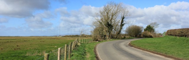
I park on a patch of rough grass near Whitrigg Bridge, where the wind hurls itself against me and the River Wampool flows fast and furious.

From the bridge it’s only a 100 yards or so to where I ended my walk last time at Whitrigg – not really a village, just a collection of houses around a T junction – and here I turn left towards Anthorn.

The wind is blowing hard in my face. Very tiring. Luckily, I won’t have to fight the wind for too long, because today I’m taking a circular route, following the shore as it curves around. The wind should be behind me soon – pushing me forward.
Most of the day is going to be spent road walking, so I’m wearing my comfortable shoes instead of walking boots. I plan to end up in either Bowness-on-Solway, or Port Carlisle, or Glasson – depending on my timing . (Mustn’t miss catching the bus back to my car. There aren’t many in this part of the world.)
The sky is constantly changing. Patches of cloud are followed by long periods of sunshine. But I never feel warm, because the wind is cold and seems to rip straight through my “windproof” jacket..
Despite battling against the wind, I soon reach Longcroft. Again, it’s hardly a village, just a collection of houses.

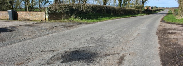
A road maintenance lorry rumbles past and then skids to a halt in front of me. A couple of high-vis workmen leap out, swing a bucket about, and leap back in again. The lorry disappears down the road.

The whole incident takes less than a minute. Weird. What were they doing?
When I get closer, I spot a patch of fresh tar sploshed across the tarmac. Aha. They were filling a pothole. I never realised the whole process could be so… so very, very quick!
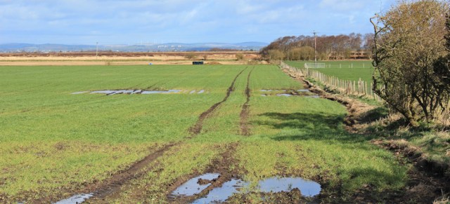
It was raining yesterday and most of last night. The flat farmland to my right appears marshy. In fact, it looks practically swamp-like. Glad I’m walking on the road.
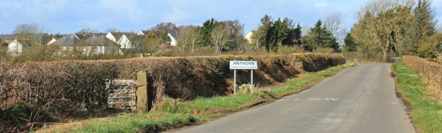
I reach Anthorn. A more substantial village than Longcroft or Whitrigg.
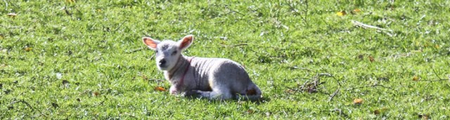
In a field to my left I see a new lamb. It’s the first little lamb I’ve seen close-up this year, and a sure sign that spring is springing.
Beyond Anthorn is Anthorn Bridge, and here the road takes on a seaside feel. A warning sign tells me it’s not safe to swim, due to “fast running tides, currents and treacherous sands”. Don’t worry. I’ve no intention of swimming today.

I leave the tarmac and walk along the bank. Very pleasant to have soft grass under my feet. Ahead is a field of tall, metal masts, something I’ve had on the periphery of my view for several days.
I come to a fence across the bank. It is possible to climb over and I wonder if I can continue walking close to the shore? The problem is… if it’s a dead-end I will waste time and there’s the bus to think about…

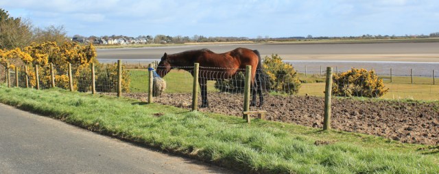
… so in the end I head back to the road, and walk past a field of very hungry, and very pregnant, horses.
I’m walking around the perimeter of the array of masts. It’s always an incongruous sight – to see lines of towering, high-tech metal structures, and with cows placidly munching the grass beneath them.

[Later I learn the masts sit on an old airfield. The land was first used by the RAF, later by the Navy, and now hosts a Very Low Frequency transmitter station, which communicates with our submarines. Don’t worry, I’m not disclosing any state secrets. This information is freely available on the VisitCumbria site.]
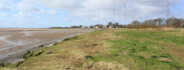
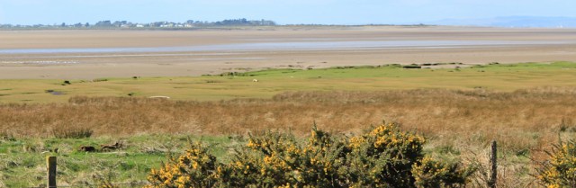
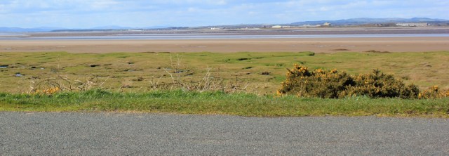
To my left is a view across open marshes and the Solway Firth. There’s my old friend. Criffel. Scotland seems so near now.

Closer to home, I can see right across Moricambe Bay too. There’s Grune Point and the houses of Skinburness. Can’t believe it took me two days of walking to get this far… if I didn’t know better, it would be tempting to wade across the mud flats of the bay…
… but I know the River Waver is in the way. And then there are the “fast running tides, currents and treacherous sands” to worry about. No. Better stick to safe tarmac.
Dotted around the fields are blocky brick structures. They seem to be used as barns and cattle sheds now, but I guess they’re remnants of the old airfield buildings.

This landscape bears the imprint of multiple conflicts. WWI, WWII, the Romans, the Scots. But it’s all peaceful now.

Further along, and I come across a mass of scattered flower blossoms lying across the grassy verge. Camelias? They seem too beautiful to leave lying there, so I pick one up and carry it in the palm of my hand for several miles. It’s petals are moist and slightly bruised from last night’s rain.
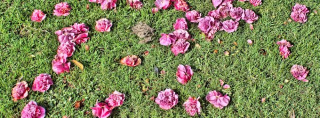
I only lose the flower when I meet the dog… but I’m getting ahead of myself.
The road has been running a few hundred yards inland and following the curve of the shore. I’m heading due east now, with the wind behind me. Much easier walking conditions and I make rapid progress.
Over the estuary is Scotland. I try to imagine walking along the far shore and looking back at these marshes and remembering this walk today – and then I decide I shouldn’t be thinking of the future all the time. It’s best to concentrate on the here and now. Enjoy the moment.

This road does seem to go on, and on, an on. Very little traffic.

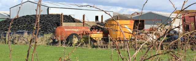
I reach a farm. It has a motley collection of machinery and the obligatory pile of something tethered down by a bunch of old tyres. But I like the bright colours and stop to take some photographs.
I was never nervous of dogs, but a nasty incident with a farmyard collie a couple of months ago – which bit me on the calf – has made me far more wary.
To my dismay, a collie appears at the open farm gate, barking furiously. And another dog – a little terrier – runs out through the hedge and onto the road. Despite vigorous barks, this little dog’s tail is wagging like mad and she comes forward at a crouch, begging to be petted. I decide the best thing to do is make friends with the little dog, and hope the collie accepts me as a friend too.
This ploy seems to work. The collie seems to lose interest in me. But now I can’t get rid of the little dog. She seems keen to come walking and trots at my heels. Just then a car appears in the distance, rollicking down the lane at a fair rate. I grab the little dog by the scruff of its neck to keep it safe (and, in grabbing the little dog, I drop my camellia). The car suddenly sees the dog and slows down abruptly, then crawls past us.
By this time, the farmer has appeared and calls to the little dog. “Come here.” The dog ignores him, and I have to walk back to the farm gate to deliver her over to her owner.
Onwards. This road really does go on , and on, and on.

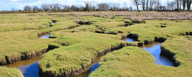
To my left the fields disappear, and are replaced by muddy grassland, gorse bushes, and low-lying marsh beyond.

I walk down towards the shore, and walk along the marsh for a while. But the ground is cut through by a network of water channels, and it is hard to make forward progress. Also, I’m not wearing my waterproof boots, only walking shoes.
So, after a few minutes of slow progress, I head back to the tarmac and continue to walk along the road.
I’m approaching a bank of land that runs out through the marsh. I know this is the English side of an old railway crossing. (I believe the original bridge was washed away by storms and never rebuilt.) Out in the marsh, close to the raised bank, a group of young people are measuring something in the grass.

By this time I’m growing tired and hungry, so I stop for a drink and a snack. I don’t eat too much, because I’m looking forward to a nice pub lunch in Bowness. And I find I soon get cold when I stop walking – the wind is chilly.
Before I set off again, I take a quick self-portrait using my camera’s timer.

Just in case you think I’m good at this self-portrait malarkey, here is one I took a few seconds earlier. You can see the most important feature in the photo is missing – me!!!
Somewhere to my left is the first of the series of Roman milefortlets. These mini forts guarded the Cumbrian coast against the marauding Scots. But all that’s left of Milefortlet 1 is a green field and a few bumps in the grass.
Onwards. I’m nearly at Bowness on Solway and the start of another famous Roman fortification – Hadrian’s Wall.

I reach the outskirts of Bowness. A sign post tells me it’s only 24 miles to Maryport (by my coastal route, it’s much further of course, about 40+ miles I reckon). Also, bizarrely, the sign points to Rome. 1,150 miles away. Why choose Rome? Dunno.
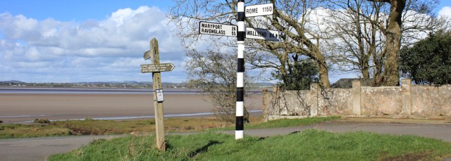
Scotland isn’t mentioned on the sign, but it may be possible to cross the Firth at this point… possible, but not advisable without a local guide who knows what they’re doing. (You can read about the ancient crossing points in more detail on Ann Lingard’s excellent Solway Shore-walker site: Waths: fords and borders.)
Bowness-on-Solway is quite a thriving place. But – and this is a big, BIG disappointment – the pub is closed. All my dreams of a nice sit-down lunch are smashed.

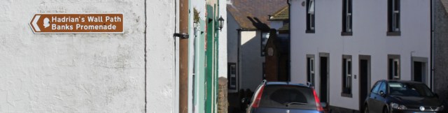
Never mind. I cheer up when I see a sign on the wall.There’s the familiar acorn icon denoting a National Trail and I’ve reached the beginning (or end, if you prefer) of the famous Hadrian’s Wall Path.
At last. I’ve been looking forward to reaching the Wall. Onwards.
[To be continued…]


Good to see you back on the road! I guess the sign to Rome is related to Hadrian’s Wall?
Duh! Of course it is – how embarrassingly stupid of me. Now it makes perfect sense 😀
Good to see you on the road again. Great scenery and I love the little lamb 🙂
Love spring walking, Eunice. Especially the lambs. I’ve sometimes actually seen them being born while out on my walks, but not this time.
Two things Ruth, the first is: some of those old aircraft buildings, the ones with open sides where used for aircraft to fire their guns into, while they were stationary. The second is: I had the exact same dogs on passing that farm, the collie barking at me, and the Terrier? Could I get rid of him? He accompanied me a good half-mile down the road, before I had to pretend to go into a field. He lost interest and trotted back home.
Thanks for the info about the buildings. Explains their odd design. And how funny you met the terrier too! I thought it was my magnetic personality… but clearly that dog will follow anybody 😉
I didn’t encounter those dogs but I did walk that stretch mostly in the rain; that’s obviously where you went wrong—insufficient precipitation, a classic mistake!
The sign to Rome is a refernce to Hadrian’s Wall and the furthest outposts of empire (which it wasn’t always, because the antonine Wall was further north). Besides, don’t all all roads famously lead there?
Insufficient precipitation? Yes. Maybe I should always walk in the rain and avoid dog bites!
And I now feel very stupid for missing the very obvious reason why a signpost near a Roman Wall would point towards Rome. 😀
I’ll be doing this walk later this year. I’m not sure you can repair a pothole in that time in such a way that the repair actually lasts! I’m afraid your experience with the pub is why I usually bring sandwiches, more to carry and less tasty, but at least I won’t go hungry! Looks like this was a bit of a frustrating walk!
Be interesting to read if you do do Hadrians Wall. I’m considering it myself. Though I think the best bits are in the middle. At either end there is quite a lot of urban walking through Carlisle or Newcastle
Hi Jon. I can’t help thinking the council found they had a bit of money left in their road-repair budget and decided they needed to use it up before the 1st April. ‘How do we spend this money?’ ‘I know. Lets hire three men and a lorry…’
Hadrian’s Wall appeals because it’s not too long (less than 90 miles) and would be another National Trail to add to my very short tally of National Trails completed. I gather the scenic bits get quite crowded.
Explains a lot about potholes and why the repairs never last. Also, the second blog post I’ve read in the last few days that has marauding Scots in it! Fortunately, we don’t maraud that much these days….
Ha ha. Marauding Scots is such a cliché, I’m embarrassed to realise I used the phrase. Actually, given my surname (Livingstone), I’m probably a marauding Scot myself!
Yes, your name sounds much more Scottish than mine!
The viaduct was actually damaged by icefloes in 1881 – and eventually dismantled in the 1930s. A sad loss as it avoided that long detour to Gretna! More at https://solwayshorewalker.wordpress.com/2016/07/26/the-solway-viaduct/ if you’re interested.
There is a good picture of it in the West Cumberland Railway Museum. https://sueswordsandpictures.wordpress.com/2017/03/15/west-cumberland-railway-museum/ Sue
Thank you Sue.
Icefloes!!! Hard to imagine. Thanks for that amazing bit of information, Ann.
Love the picture of the camellias they look hyper real and the accompanying story with the dog! Do you reckon you’ll find time to walk Hadrian’s wall once you’ve finished with the coastal path?
I’d love to walk Hadrians Wall. Actually did a couple of sections when I was a schoolgirl (part of a Latin field trip, and the only good thing I can remember about doing Latin O level!).
Welcome back – been awaiting with eager anticipation since seeing your tweet on reaching Scotland. I am interested to know if you make notes along the way as I can never remember details of a walk route accurately as you do or perhaps the photos are sufficient to jog the memory?
Hi Jacquie. Yes, I find my photos are the best way to remember the walk. Just one picture can bring back so many vivid memories. I also make notes on my OS map, e.g. very muddy here, or fantastic views. Used to try to keep my maps clean, but then decided to write all over them. 😄
Aah! I write on my maps too ;makes them really personal when looking back. I also have some old maps on which, to my surprise, my very fastidious father had made teeny notes; they are very precious to me.
Ah. That’s a lovely reminder of your father.
When I first started my trek, my husband would put my old maps up on eBay. But we rarely sold any, and so I decided it was OK to scrawl all over them. Also I write bus and train times down on the map, and addresses and telephone numbers for B&Bs, taxis, ferries etc. So all the info I need is in one place.
Several times now I’ve almost acquired dogs on my walks when they’ve decided to follow me. I’m not really a dog person though. I’m glad your little dog came to no harm and was reunited with its owner.
Hi Ruth – I loved this post! I grew up at Whitrigg. Good luck with your walk 🙂
Hi Matt, and glad you enjoyed reading about the walk. What a lovely area to be brought up in, although I suspect you didn’t appreciate the isolation when you were young! Best wishes.
Glorious scenery captured so well in your photos.