
It’s rained overnight, and I set off from Palnackie on a dull morning. My planned route is going to be tortuous, following Core Paths and winding around a couple of long peninsulas.
The lane climbs steadily uphill, and then the sun comes out, lighting up the landscape. Urr Water looks empty with the tide out. It’s still raining over the hills of Dalbeattie Forrest.
I think of my husband on his bike, and hope he is OK. (I informed him it never usually rains in Scotland, but he’s brought bad weather with him!)
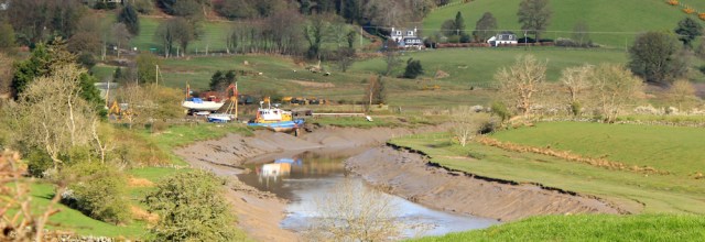
Looking back, I get a good view over tiny Palnackie Harbour. I wonder if those boats ever move?
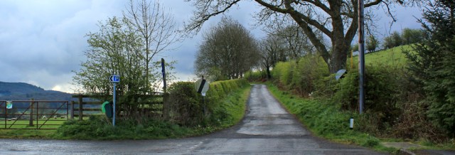
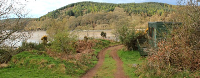
The road peters out and becomes a track. I see Forestry Commission signs. This is Tornat Plantation. According to a notice, the core path through the wood was closed due to “tree felling works”. Closed? Luckily it’s been reopened now.

The woods are lovely, but rather scarred by the recent tree felling operations.

I see a pile of logs marked with strange symbols. Wonder what they mean. Why 3.7%?

After walking through the woods, I come down to an area where the ground is low and level. The core path apparently takes a right-angled turn at this point, although I can’t see any further signposts. I check my map.
The higher land ahead is called Glen Isle – and looks like it was once a true island. I see the track leads straight towards it and I can’t resist continuing.

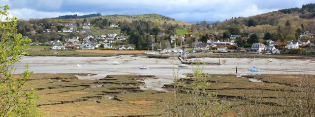
I’m soon walking up over the top of the Isle, thorough some lovely old trees. There’s a wonderful view to my left, across Rough Firth, to the pretty village of Kippford where I walked yesterday.
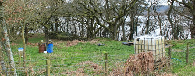
Glen Isle isn’t large, but the woodland is dotted with small cabins. Holiday homes. Weekend retreats. I hear the noise of a generator – I suppose there’s no mains electricity here – and a man opens the door to his hut and steps outside. He’s drinking a cup of coffee and only wearing underpants. Is startled to see me. Darts back inside.
I guess he wasn’t expecting to see a woman with a camera! Feeling like an intruder, I hurry on.
Nearing the tip of the Isle, I force my way along a vague path, through gorse and brambles. Finally, I reach a high vantage point and can go no further. This must be the far point of the peninsula. Isle Point.
Over the water – gleaming too bright in the low sun – is the familiar sight of Rough Island with its causeway. In the blue distance are a line of turbines and, beyond, the vague outlines of Cumbrian hills.
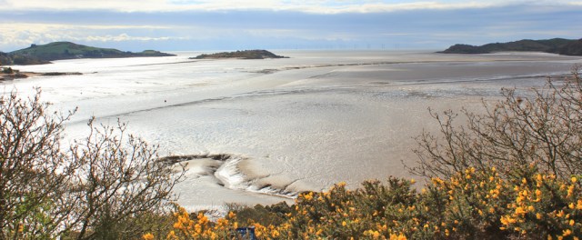
I’m glad I made it to the end of the Isle. These views are lovely.
When I turn to my left, I see I’m very close to Kippford…
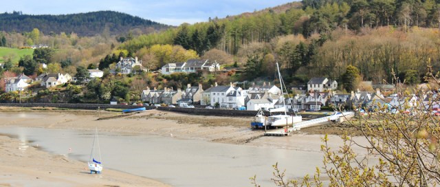
… and so, after many miles of walking, I’m only a few hundred yards away from where I was standing yesterday!
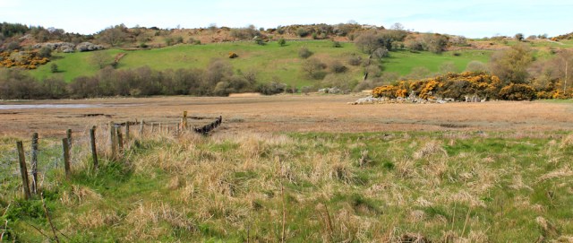
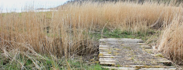
After enjoying the views, and taking masses of photographs, I walk back along the tracks through Glen Isle and return to the low, flat area. There are no footpath signs, which is rather worrying, but I know the Core Path should run along the edge of the marshy bay and over to the next peninsula.
Following a line of fencing, I set off across the marsh.
After a while, I’m not sure if I’m following human footpaths, or sheep trails, but I keep going. There are plank bridges across some of the more boggy parts – a reassuring sign.
It’s a relief to make it across without any real difficulty. On the next peninsula, I join a well-trodden farm track, which soon becomes a green avenue, lined by trees.

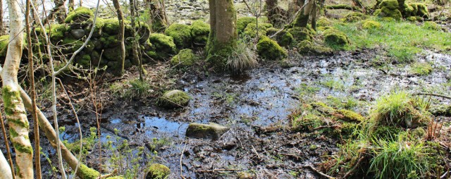
At times, small streams run across the track, and the ground becomes very boggy, treacherous with sticky, sucking mud. I leap from stone to tussock, balancing awkwardly and glad of my walking pole.
Further on and trees have fallen across the path. Someone must be looking after this route, because the larger trunks have been sawn through to make a clear passage.

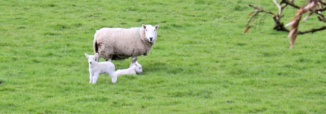
Eventually, I pass a few buildings, and emerge onto a green field full of sheep. The track takes me past a large pink house – Almorness House, according to my map.

I love this time of year. A couple of lambs watch my progress with inquisitive looks.
On the other side of the field are the waters of Rough Firth. Kippford is further up the estuary, hidden from view, and I realise I’m looking over towards Rockcliffe and Castlehill Point. The sun is shining on the grass and gorse of the headland, and I remember how much I enjoyed walking along that particular stretch of coastline.

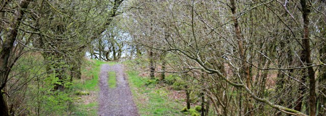
At this point in my walk, the Core Path loops inland along the driveway of Almorness House. But I was hoping I could continue to the tip of this peninsula, and so I’m delighted to see a clear track leading straight ahead.

This section of the walk is lovely. The woods are old and silent – apart from birdsong – with a number of tracks giving alternative routes.
It comes as a surprise to see another walker coming towards me. ‘Lovely day.’ Yes.

And another surprise when I emerge from the woods and discover a curve of sandy beach. Horse Isles Bay. Unexpected and wonderful!

I follow a path on the other side of the bay. It leads up the slopes of a low, rocky headland… but then fizzles out, leaving me stranded on the side of fractured cliff. Must be a sheep trail, I decide. Still, I enjoy another good view across to Rockcliffe and Castlehill Point.

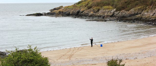
I lose my way a little. The going is tough. I clamber over rocks and trudge through a marshy area, before I arrive at another surprising beach. This one has a lone fisherman standing with his line on the sand.
Perching on some rocks above the sea, I find a place out of the wind, and settle down for a picnic lunch. The fisherman spots me and waves. He looks young – a teenager. I notice a makeshift tent with another fisherman – maybe his father? While another man is collecting wood for a fire. I hope the lad catches something for their lunch!
I check my map and realise I haven’t reached the final tip of the peninsula yet – Almorness Point – the headland on the other side of this beach. But I decide the terrain is too difficult and I’m close enough.
After I’ve eaten, I quickly grow cold in the chilly breeze. Time to head back inland.
I tramp through a marshy area, before rejoining woodland tracks. Here I branch off along a track that runs towards the west side of the peninsula, and enjoy a good view over towards Auchencairn Bay and Hestan Island – another tidal island.

The landscape is a mix of woods, fields, and fenced off areas which, I think, are sites for rearing pheasants or partridges. I hear the constant chatter and whirring of game birds in the undergrowth.
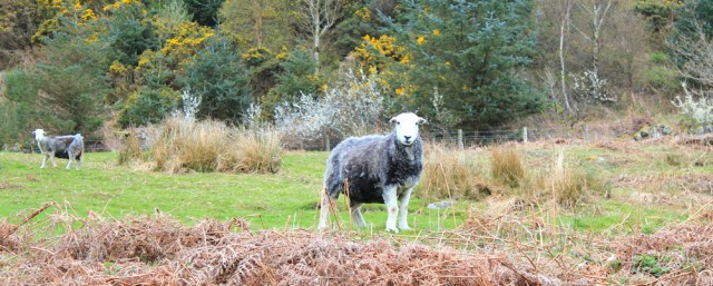
There are sheep here too. Herdwick. I love their grey/blue coats. They seem surprised to see me.
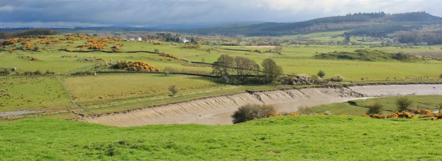
I’m walking up the edge of the peninsula now. The area of water and marsh below me is called Orchardton Bay. My track ends in a sheep field, where I inadvertently start a stampede.

Feeling rather guilty, I make my way around the edge of the field, and let myself out through a squeaky gate. There’s another field, and another gate… and I’m back beside Almorness House.

From here I follow the access drive, heading northwards. It’s a long, straight lane. I’m growing tired. Near the gates that mark the end of the public road, and the beginning of the drive, is a small car park.

That must be where the fishermen park. It’s a long trek to the beach from here, nearly 3 miles.
I walk up the road, past more fields of sheep. I think these are Cheviot sheep. They have very perky ears, so they look both alert and inquisitive.

I turn off down another lane, heading towards a stone tower. At first I think it’s a ruined windmill, but when I get closer, I realise it’s the remains of a fortified structure. I check my map. Orchardton Tower.

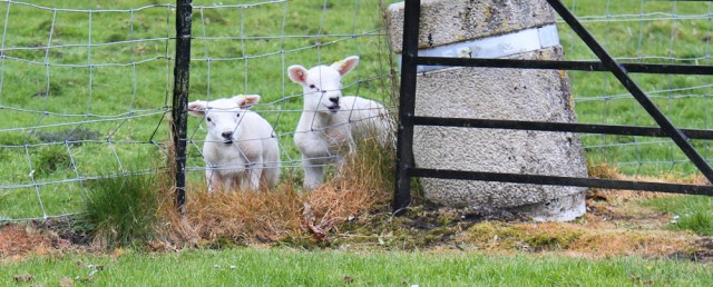
I sit on a stone at the base of the tower and have a drink and a snack. A couple of lambs come and stare at me through the fence. They seem remarkably unafraid.
From the tower, I walk up the road to rejoin the A711 again. After many miles of walking, frustratingly, I’m only a couple of miles away from Palnackie at this point!
There is no pavement, so I walk on the edge of the tarmac. A car slows down beside me. It’s one of the fishermen from the peninsula. He offers me a lift but I tell him I must keep walking. Before I’ve gone much further, a second car slows down beside me. It’s my husband. He offers me a lift too, but I explain I must keep walking. (Really, my husband should know this!)
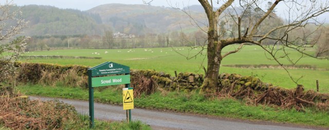
My own car is parked in an official car park by some woodland further along the road. Screel Wood. I haven’t quite reached Auchencairn yet, but am very close.
Why did I refuse lifts? Because this is a convenient starting place for tomorrow’s walk – and I must always start my next walk from the place I ended my previous walk.
You can learn more about Orchardton Tower on Wikipedia. It turns out to be the only cylindrical tower house in Scotland.
Walked today = 11.5 miles
Total around coast = 3,152 miles
Route:


Hi Ruth – you might remember that I completed by circumnavigation last September, but I am beginning to get itchy feet again! You are doing really well and it just keeps getting better and better all the way up the west coast (even the Clyde has its moments!). What a difference the tide makes, fortunately I was able to walk across the mud flats from Tor Point to Almorness Point which saved almost half a day. As I suspect you have already discovered, you’ll have an inland stretch for most of the way to Kirkcudbright unless the MOD have granted some access.
Hi John, and how wonderful to hear from you. You were very brave to attempt that crossing. Did you know it was possible, or did you just set off on spec? Sounds like you need another epic walking challenge to deal with those itchy feet. 😁
I always enjoy reading about your walking . 🙂
Thank you, Simon.
Ruth,
I am enjoying tracking your tortuous route around all those little headlands – I must admit I would have been tempted into a few short cuts.
Knowing of your interest in signs I thought you might like one I spotted above Towan Beach, Roseland Penisula:
https://keithcase.wordpress.com/2017/05/06/156-portscatho-to-st-mawes/ (third photo)
Good luck,
Keith
Hi Keith, yes, pretty tortuous. Enjoyed reading your blog post, and what a graphic little sign. Well spotted!
Hi Ruth, I think the timber numbers refer to the length of the timber in metres, there is no % sign, it is o/s which could mean over/size or outside.
I did read John Gales blog and tried to cross Orcharton Bay, but the tide was in. Question to John Gale, first thing congrats John on finishing your challenge last year[?] My question: why did you stop writing your blog on day 342?
Ah, yes Alan. You’re right. I misread the o/s as o/o 😄
Ha ha, did your husband believe you when you said it doesn’t usually rain in Scotland?! Saturday here was awful: I hope you weren’t caught in that.
It always rains when my husband joins me! I just escaped the rain on Saturday because I drove home that morning, after enjoying 2 weeks of almost interrupted Scottish sunshine 🌞
I know, it’s been unheard of! By the way, I saw someone below asking about core paths – I’d never heard the expression till you mentioned it in your posts. Maybe it’s just a Galloway thing?
I think they are supposed to be developed across the whole of Scotland. http://www.snh.gov.uk/enjoying-the-outdoors/where-to-go/routes-to-explore/local-path-networks/ The maps are quite deceptive though. If you click on the description of the paths, some will be classified as ‘incomplete’ – which means they don’t really exist. Or even ‘disputed’ !!!
Well, you live and learn! Navigated to the Glasgow City Council section and it’s most un-user-friendly, so I’m not much wiser. I think one of those “more honoured in the breach than in the observance” kind of schemes.
Bravo for finding the path across the marsh at Glen Isle, squelchy though it sounded! I couldn’t find it all but I suspect that may have been partly due to the tide
It wasn’t a very clear path, Ju, and yes I suspect it might be impassable when the tide is in.
Great to read about that walk and see the photos. It took me two attempts to get to Hestan Island for No Boat Required. The first I walked from Palnackie (two buses from Kippford) along that long lane you came back on, then left to Horses Isle Bay – a lovely spot. Like you I found it hard from there and had to climb over big rocks by the shore. The tide never dropped enough to walk to Hestan Island so I came back six months later. Then I had a car and parked where your fisherman did and walked over the hill on what was a fairly rough path. When the tide dropped I had about half an hour on Hestan Island, taking great care as I’d been warned off quicksand. I too met sheep on the way back and got some good photos of dogs working them along the lane. Reading your blog has made me want to go back to this little known but beautiful part of Scotland.
I thought of you when I saw Hestan Island, and couldn’t work out how you would have got there! Yes, it’s a beautiful area.
I walked from Almorness Point. Across mud then The Rack, a natural causeway of cockle shells. However walking to Hestan Island without a guide isn’t recommended unless you are familiar with the tides and area.
What is a core path?
They’re the closest thing Scotland has to a public footpath, designated walking routes described by the local council. Some really exist, others are mere wishful thinking! http://www.dumgal.gov.uk/article/15304/Core-paths-in-Dumfries-and-Galloway
I bet the guy in the underpants was surprised to see you! 🙂
I think if someone had offered me a lift I wouldn’t have refused, especially if it was my hubby 🙂
I think I ruined his day – the underpants guy – not my husband. 🙂 The trouble with accepting a lift, is I know I’ll have to go back and complete that section of the walk anyway, so I better just get on with it. (That’s the trouble with making rules and sticking to them!)
Pingback: 474. Dalbeattie to Auchencairn | Round the Island