
Today my planned walk follows core paths from Garlieston to the next village along the coast, a place called Isle of Whithorn.
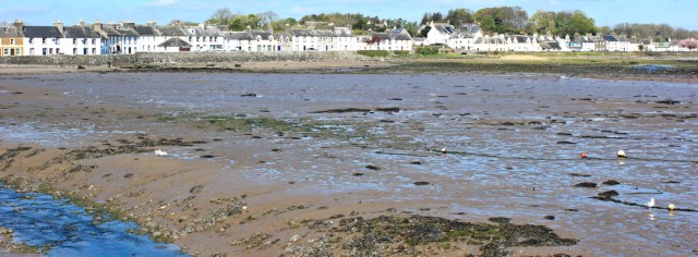
After my wonderful experience on core paths yesterday, I’m not anticipating any problems. So I set out from Garlieston full of optimism, and walk around the edge of the harbour. Even with the tide out, and with mud everywhere, the bay looks lovely.
I know the spelling is wrong, but I can’t get that Glen Campbell song out of my head. Galveston. Oh Galvesto-uh-on.
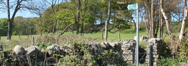
Leaving the harbour, I soon spot a core path sign. “6 miles to Portyerrock” What?! To where? I thought I was heading to the Isle of Whithorn.
I pull out my map. Portyerrock turns out to be on the way to Isle of Whithorn. It consists of a bridge, a bay and a small collection of houses.
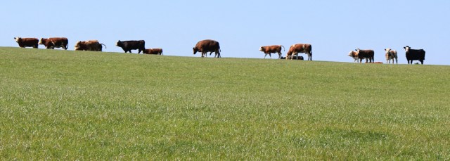
My path runs along the water, and then through a spooky grove of dead trees, where I meet a herd of cows. Now, I really don’t like cows, but I hold firm and continue walking towards the beasts, until they begin to amble away.

Safely beyond the cows, I relax, and really enjoy this section of walk. The woodland continues alongside the water, with more glorious carpets of bluebells. Beautiful.

I reach a broad, shining bay. It seems a popular place. A couple are sitting on deck chairs, overlooking the water and reading their papers. While, out on the sand, another couple are walking their dog.

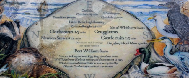
‘Rigg or Cruggleton Bay’ says my map. But local information boards use the name, ‘Mulberry Harbour’. Apparently these were temporary, prefabricated harbours that were assembled and tested here for use during the final stages of WW2. [You can read about Mulberry Harbours on the Combinedops.com website.]
Another information board – prettily painted with a collection of local wildlife – tells me how far it is to various points across the sea. Workington, in Cumbria, is only 35 miles away. Crikey! I walked through that town ages ago, but I’ve really not come very far at all!
Onwards. I leave the Mulberry Harbour bay behind, and a little while later I step off the path to let a pair of faster walkers overtake me. Yes, I’m slow.

But this walk is too beautiful to rush. I do love these coastal woodlands. So peaceful. Full of birdsong and, of course, bluebells.

Further along, past the wonderfully named Sliddery Point, the woods come to an end, but the bluebells just refuse to give up growing. They cover the scrubby landscape with their nodding blossoms.
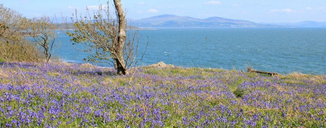
[I love the different blues in the photo above: the violet of the flowers, the aquamarine of the sea, and the softer grey-blue of the distant hills, all beneath a light cerulean sky.]
I’m busy taking photographs when another couple overtake me, striding purposefully along with their collie dog. The collie stops to look at the ladder stile, and seems to be asking ‘OK, how do I get over that?’, but there’s no need to worry. You can go through the gate.

I follow the couple over a field and watch as they climb up to sit under a ruined arch. That’s the remains of Cruggleton Castle.
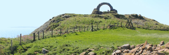
After giving them a few minutes of privacy, I climb up to join them. The views are wonderful, but the wind is cold and bites my skin. The woman pulls on a jumper, but they’re both wearing shorts. Must be freezing! Perhaps that’s why they don’t stay long.
They start off continuing southwards along the coast – and I assume I’ll be following behind them for the next few miles. But then I see them reach a gate, stop, turn around, and head back towards Garlieston.
I climb down from the ruined castle, and go towards the gate. Uh oh. An ominous sign. ‘All Persons Pass This Point At Their Own Risk. BEWARE. Cows with Calves.’
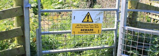
Great. Just what I need. But the sign doesn’t say I can’t go forwards. It just says it’s at my own risk. Well, I’m brave and bold. Onwards.
The sun is in my eyes, making photography and looking ahead difficult, but the view behind is stunning.

I keep an anxious watch for cows. But I only see a few brown humps on the horizon and – pfff – that’s nothing to worry about.

I reach an abandoned look out point. Is this another WW2 relic?

Beyond here is an enormous field and more warning signs. I’m nervous of cows at the best of times, but these dire messages – ‘Take Care’ and ‘parent animals can be aggressive’ – are really winding up my anxiety levels.
‘Please use another route if possible.’ Yes. Fine. But where is this other route? Doesn’t exist. Unless I turn back… no. No. No. Don’t be a coward. Onwards.
When I spot a groups of cows with calves on a slope ahead, watching me, my anxiety level shoots up from rather-high to screamingly-high.
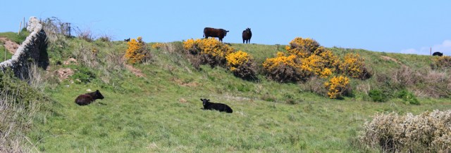
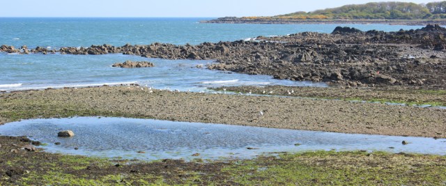
I hurry down to walk close to the rocky shore. But there are more cows along the coastal strip – standing over their teeny little calves and staring at me, heads lowered. Giving me the evil eye. Uh oh.
Quickly, I leave the grass and begin to climb over the rocks along the shore, hoping that cows can’t follow across this difficult surface.
And so I become a reluctant coasteerer. I splash through pools, slip on seaweed, and haul myself over jagged barriers, before sliding down the other side on my bum.

With such fractured terrain, it takes me ages to make any forward progress. I begin to wonder where the worst danger lies. Being trampled by cows? Or breaking my leg?
A beach of pebbles and boulders makes an easier walking surface, although the shifting stones are treacherous underfoot. I think this place is called Port Allen, but to be honest I’ve given up on checking my map.

The beach soon comes to an end, and I continue my scramble over more rocks.
I cross a little stream via a bridge (a route that takes me too close to cows for comfort and I don’t stop for photographs). The field on the other side is also full of cows and young calves. Uh oh. I head back towards the rocks.
Then I come to a full stop. A group of cows are munching on a grassy platform straight ahead. But the rocks below are too difficult to attempt. What should I do?
The group have noticed me. Heads up. Watching. I duck down between two tall ridges. Here I feel safe, hidden from view. I wait for the sound of charging cows, but everything is quiet, apart from the gentle break of waves on the rocks below.
I begin to relax. It’s actually a very pretty place. Maybe time for lunch?

When I’ve finished eating, and get up again, the cows have disappeared and the way forward is clear. Thank goodness!
Onwards, sticking close to the shore but making use of the scattered patches of grass between the rocky outcrops, I make better progress.
A noise above gives me a nasty startle, but it’s only a group of lambs. Perky-eared Cheviots. They watch my stumbling progress, looking as anxious as I feel.

Finally, I make it to the far side of the field, where I must scramble up a steep slope (lots of slippery mud underfoot from a nearby spring) to reach the gate. Whew. I survived!
My heart nearly stops, because there are cattle in the next field too. But – big relief – I think these are young bullocks. They keep their distance. Even move away when they see me.
Beyond this field, more cows and these ones are standing very close to my path. But I feel emboldened because I also see a farmer on his tractor. He is ploughing up the field for some reason, with seagulls shrieking overhead.
The cows look unperturbed by my presence, and similarly unperturbed by the sight of the farmer chewing up their food source. Silly moos.

This seems to be the last field of cows I must cross, and now I can relax and enjoy the rest of my walk.
The coast here is really spectacular. Despite all my anxiety and difficulties, I’m glad I persevered. But why can’t the coastal strip be made more walker-friendly? Shame.
Ahead is Miller’s Port, Port Henry and Portyerrock Bay. The headland in the distance is Cairn Head.
But to reach Cairn Head I must turn inland and join the road at Portyerrock. Luckily, it’s a quiet and pretty road, taking me around Portyerrock Bay…
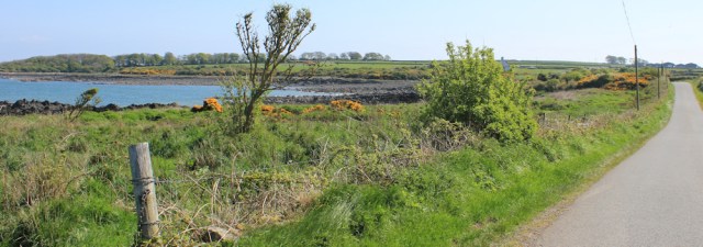
…until I see another Core Path sign. Isle of Whithorn. Just over 2 miles ahead.

The path, disappointingly, seems to fizzle out in a marshy area of grass and rocks. Luckily I see a local man coming towards me, and he seems to know the best route through.

I walk along the shore. This is tiny Cairnhead Bay. An old brick building lies among the rocks, possibly a square pillbox. I’m too tired to take a closer look.

Up on Cairn Head are plenty of other brick ruins, and the remains of old roadways. They look 20th century to me, and are quickly being reclaimed by the surrounding vegetation.

Just off Cairn Head is Doctor’s Rock, which seems to have deep personal significance for me (I’m a doctor and one of my school nicknames was ‘Rock’) but with such a craggy shoreline I can’t make out which rock it is.
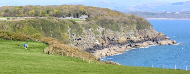
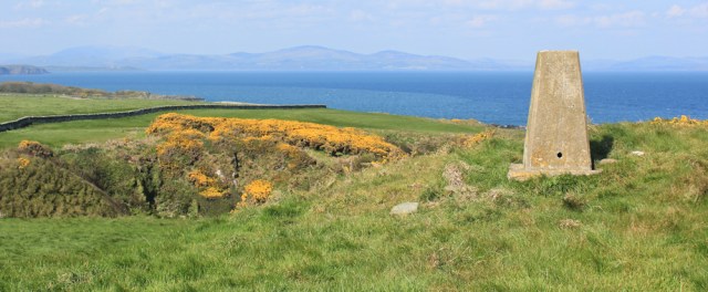
Now I walk across low cliffs. The sea is beautiful, the rocks continue to be striking, and the distant hills make a stunning backdrop.

I pass by tiny, narrow coves and the scenery reminds me of Cornwall. The names on the map are easier to pronounce: Carrickaboys, Steinhead Point, The Clept, Boat Rock, Stinking Port. Stinking Port?!
Above Stein Head is a trig point. I climb up. Can’t resist a trig point…
…it makes such a convenient surface to balance my camera for a self-portrait!
Behind me is the coast of Cumbria. I can even make out, I think, the plume of steam from the paper factory near Workington.

Onwards, and an easy walk towards the Isle of Whithorn. It’s not really an island, it’s a rocky peninsula, but you can see how it got its name. Unfortunately I’m walking straight into the sun, and my photographs as I approach the Isle are poor quality.

I end up in a strange estate. I think it’s an old people’s complex but, while many of the traditional Scottish cottages look like English accommodation for the elderly, these look starkly modern.

Near the entrance to the estate is a sign. I only stop to read it because the word ‘PRIVATE’ makes me think I might have been trespassing. But it turns out to be a joke.

I know it’s not original – I’ve heard of other similar signs – but it makes me smile.
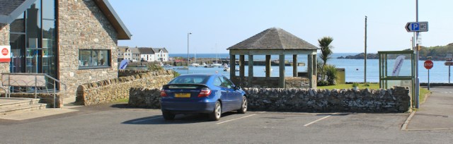
My car is parked outside the everything-shop – a combined Post Office, grocery and café. I go inside, and wanted to buy a pot of tea and a cake, but I discover it’s 5 minutes until last food orders at 4pm (why such ridiculous early closing?) and the serving girl looks keen to close up. So I just buy a bottle of cold drink instead.
This morning I caught the bus to Galveston Garlieston from the bus stop nearby. When I arrived I was surprised to see that the bus shelter was crowded. For a change, I thought, I wouldn’t be the only person on the bus. But, just before the bus arrived, everybody else stood up and moved away. They were only using the shelter as a meeting place out of the wind!
Before I leave the Isle of Whithorn, I go for a walk around the peninsula. It’s a pretty place, but rather sleepy, although the pub on the harbour seems quite lively, considering it’s only 4pm.

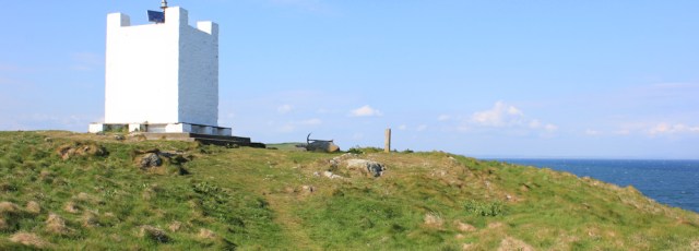
On the tip of the Isle is a white tower. A navigation aid.
What makes the Isle special are the ruins of St Ninian’s Chapel, probably around 700 years old, and standing in an impressive spot.

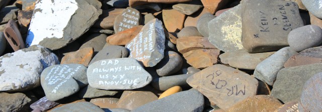
In fact, the Isle of Whithorn is the end (or beginning) of a pilgrimage route. And a Pilgrimage Cairn has been constructed on the site of an old lifeboat station. It’s a rectangular brick structure in which pilgrims are invited to place a special stone.
I guess the stones are supposed to be of religious significance – ‘a symbol of an act of witness’ suggests a nearby engraving – but they appear to be mainly dedications to loved ones.
Miles walked today = 11 miles
Total distance = 3,269 miles
Route:


Looks like bluebell heaven up there.
I’ve never experienced such wonderful bluebells. Such an intense experience.
Love the bluebells out in the open with the sea behind, lovely colours in the self portrait _ couldn’t see any naughty school girls in the St.Trinians shot!
Those colours were amazing, weren’t they. As for the St Trinians schoolgirls, they were hiding behind the cows!
I can feel the fear with those cows and calves! Great pictures and I’m really enjoying your walk.
Thank you Chris.
I can’t believe they haven’t started using that Glen Campbell song for Gaviscon indigestion remedy…
Ha ha. Excellent idea! Maybe he hasn’t given his permission?
I expect it was a relief to finally come to a walk with a decent amount of path rather than roads. I know I’ve spent a lot of time in Scotland trying to make my way along rocky foreshore or pebble beaches and that it can be hard work. I suspect the cows would have moved out of your way, but I can understand you not wanting to find out in case they didn’t! I’ve got used to Scottish “path” signs showing some obscure hamlet or farm rather than the expected destination. I’ve still yet to work out why so many place have “Mains” as part of their title, though.
This part of Scotland is interesting. You’re actually further *south* than Carlisle now, despite being in Scotland not England. I don’t think many people realise some of Scotland is south of England! If you could see Whitehaven from there you could probably have seen the Isle of Man too, as it’s about the same distance.
Mains = an estate’s main farm so if a place is built on former farmland it often keeps the name.
Thank you Anabel, you have taught me something new!
Taurophobia!! No, I don’t think your fear of cows etc is irrational – I like most walkers have had close encounters with marauding masses of bovine, ovine, equine and wildfowl over the years – A horse galloping towards me saw me take a rapid flesh ripping short cut through a barb-wire fence, a young ram kept, well, ramming into me, also the usual scary feeling of being surrounded by cows with potentially murderous intentions on many occasions and even attacks by aggresive geese and swans, all add to the rich tapestry of a long distance walk…
Enjoy!!
Gemma.
I walked past a group of rams last weekend. They are BIG, aren’t they. Another thing to add to my list of terrifying things 😆
We had coffee and a scone in the cafe, but that was “elevenses”. We also enjoyed our walk round the island (I think it was a real island originally and that long, straight street was a causeway). This will probably be the last of your posts which overlap with our recent weekend in D&G so I look forward to pastures new!
Hi Anabel. We have been tracing the same routes, haven’t we? Yes, I think you’re probably right about the Isle of Whithorn once being a true island.
Cattle certainly deserve a healthy caution; they can do an awful lot of damage should they choose to. You and I seem to have very different responses to them though—I’ll take a field of cows and calves over a field of bullocks any day! I find that cows with calves are much less bother so long as you don’t commit any of the three cardinal sins:
1. Have a wolf on a stick, or
2. Get between a mother and her calf, or
3. Back them into a corner, causing them to panic
So long as you don’t do any of those things, a cow will generally decide that the safest and easiest thing she can do to protect her calf from any Terrifying Calf-Eating Walk Monsters is simply get right out of your way. Bullocks on the other hand seem to egg each other on to misbehave.
This of course comes with the whopping great caveat that cows are living creatures and any particular individual might not have read the right books on animal behaviour. It’s all fun and games until you meet one with a spongiform brain that thinks it’s actually a rhinoceros.
I blame all the threatening signs for winding me up! That, and my total cowardice of course 😄
Wonderful photographs today and yesterday Ruth, beautiful colour blue of the sea in your first picture of Garlieston Bay. How lovely ref the bluebells, the perfume must have been intoxicating. I have noticed at a local bluebell wood near us is that the bluebells have been very vivid in colour this year and the perfume wonderful. The rivers of bluebells are a beautiful sight to behold. Lovely perfume too from gorse. Wishing you all the very best on your walks. Kind Regards, Lynn.
Thank you Lynn. Yes, I believe the bluebells have been more spectacular than usual this year. It’s been an amazing experience to walk for miles surrounded by them. Best wishes.
Great photos, and the Isle of Withorn looks really nice 🙂
You would love this area, Eunice. So many interesting little places to discover.
The signs are there to intimidate. The get orf moi land types here have to be creative as there is a long tradition of contempt for them now backed up in law. By now you will have met most of the tricks. The most effective is houseblocking … if there is building by a path, the surrounding land is exempt from access rights, so they can lawfully deny access.
Hi there, and I’ve noticed quite a lot of house blocking too. Well, the signs certainly worked, because I was VERY intimidated! Shame that along such a lovely stretch of coastline I was made to feel so unwelcome 😖
The locals are stranger than the zombie cattle and devil sheep Ruth lol why do you think they filmed the Wickerman here?
Glad you enjoyed your walk
Brian (a local but not born here so only have 8 fingers and 2 thumbs)
Hi Brian, and what a lovely place to live. Interestingly, most of the people I chatted to while I was in this area turned out to be English, not locals. Makes me wonder if all the original inhabitants have turned into Zombies too!
lol your right most of us here are English asylum seekers 😎 we don’t have riots and car thieves here, your route went past my home big white bungalow on the hill so it doesn’t flood lol
have fun
Brian
ps its a shame that Cruggleton Castle isn’t still there as it apparently had 8 turrets trimmed with lead from the Isle of Man
Wonderful views. A walk marred only by all the cows. My heart would have been racing! I did have a chuckle at Helpful Mammal’s comment about a cow thinking it is a rhinoceros
Yes – and I’m happy to believe they really are rhinoceroses in disguise!
You just sound like me with the cows, they terrify me 😂. You wouldn’t have got me through the first field 😱
Great walk report. I hope to do the Garlieston to Portyerrock section soon, as I’m working my way along the Galloway Coast (in no particular order). Thanks for sharing.