
The harbour at Portpatrick is run by a Community Benefit Society (a charitable set-up). The dock is quiet but active, with several pleasure craft and a handful of working vessels currently moored.

I’m feeling a little frustrated. I got up early and drove to a village called Leswalt – my planned walking destination today. But I must have misread the timetable because I discovered the bus I was hoping to catch doesn’t run on this particular day of the week! So I had to hang about and catch a later bus to Stranraer, and then a second bus to Portpatrick.
Quite a journey, and that’s before I started walking.
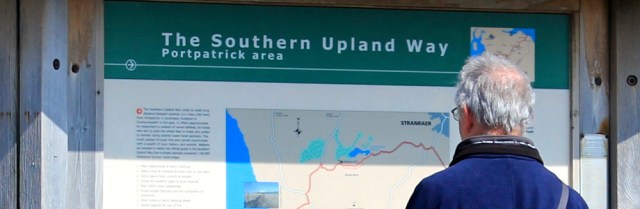
Anyway, I’m here now and I’m hoping the first section of my walk will be straightforward, because it follows the Southern Upland Way. This is a recognised footpath and one of Scotland’s Great Trails.
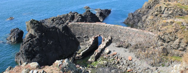
I climb out of Portpatrick and on the way up I stop to look down at the ruins of… of what? Another harbour? A private dock?
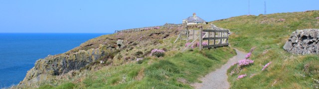
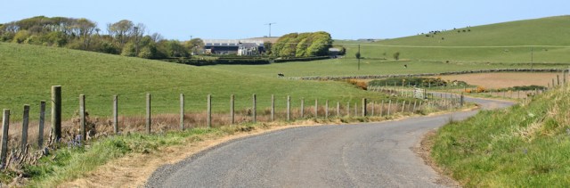
The route is, indeed, easy to follow. First I climb steps up the cliff, and then there’s a clear gravel path across the top. Ahead is a ruined house and beyond that are the masts of a radio station, now closed.
In England and Wales we have National Trails, marked by an acorn logo. In Scotland, the equivalent are called Great Trails and are marked by a thistle. This is the first time I’ve been on a Great Trail, and it gives me a little thrill to see the logo on a marker post.
![]()
I walk past a golf course. So many of them in Scotland. You would think the Scots do nothing but play golf!

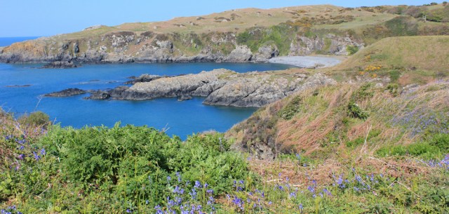
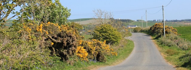
It’s a beautiful stretch of coast, with blue sea, gentle cliffs, and fragrant gorse lining the slopes.

Ahead are a duo of bays. The first one is… I check my map… Port Mora. The second one is called Port Kale.
Port Mora has beach of shingle and sand. Obviously a popular place, there are several couples walking around, and people sitting on the beach.

I cross over to the far side of the cove, work my way round the next little headland, and drop down to Port Kale.

Here I find a couple of quaint looking huts. “Coastal Interpretation Centre” says a sign. Weird name. Is this an “Information Centre” in disguise? Clearly not open for the season yet… or maybe it’s permanently closed… looks abandoned.

Nobody else around. Where are all the long-distance walkers?
I cross the shingle beach and hunt for the continuation of the path. It’s hidden among rocks and takes me on a steep climb up to the next headland. Great views.

A sign at the top warns me to “take particular care” because “the cliffs in this area can be DANGEROUS”. Oh dear! Perhaps you have to be a proper walker to walk the Southern Upland Way?
I begin to work myself up into a state of anxiety… when I suddenly realise something. The warning sign is intended for walkers coming down this cliff, the same cliff I’ve just successfully climbed up! Silly me. Nothing to worry about after all.
I’m high above the sea and walking across an undulating plateau of rocks and grassland, with occasional steep drops into little valleys. Ouchtriemakain Moor. Ahead is a lighthouse.

I really enjoy this section of the walk. Perfect weather and dramatic scenery with interesting terrain – not too easy, but not too demanding either.
The lighthouse looks imposing and is still in use, I believe. There’s an old foghorn on the cliffs below. Although it sits on a promontory called Black Head, the lighthouse seems to be called either the Killantringan Lighthouse or simply the Portpatrick Lighthouse.
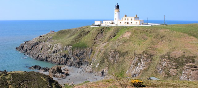
When I reach the lighthouse, I discover the surrounding buildings are privately owned and so I can’t wander around.
I make my way to the access road and a small car park. People are sitting in their vehicles, admiring the views. The bay ahead is called Knock Bay and I believe there is a core path that runs along this stretch of coast…

…but I’ve decided to follow the route of the Southern Upland Way instead, which heads inland at this point. Why? I’m still feeling shaky following my recent encounters with aggressive cows and bullocks, and I want to minimise my chance of meeting the beasts today.
So, I follow the access road as it heads from the lighthouse towards the main road. Unfortunately, I haven’t got very far when I cross over a cattle grid and find myself… yes… in a field of cows. And they have some very, very young calves with them.
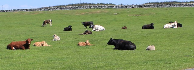
Although the cows don’t seem too bothered by my presence, I’m very bothered by theirs. I climb over a gate and into a neighbouring field, and walk parallel with the road until it’s safe to climb back.
Such a coward!
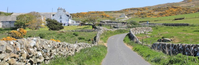
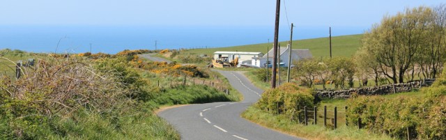
The road leads up and past a farmstead, called Killantringan, same as the light house. They both get their name, I would think, from the high fell to my right called – yes, you guessed – Killantringan Fell
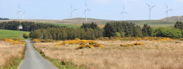
I walk over the shoulder of the fell, sticking to the road. Ahead is a line of wind turbines and I enjoy watching their blades turning gracefully in the light breeze. Strangely hypnotic. (Some people hate wind turbines, but I rather like them.)
I reach the junction with the main road and turn left. When I call this the “main road”, it’s really very quiet and I only meet a handful of cars all day.

After a few hundred yards, I part company with the Southern Upland Way. It turns off down a minor road, heading vaguely eastwards, but I’m continuing north.
In the next field – at a place called Knock and Maize (what a name!) – is a standing stone.
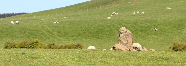
It takes me a while to get a decent photograph of the stone, because I have to wait for the sheep to get out of the way.
From here the road winds tantalisingly close to the shore. Only 1/2 a mile across the fields.
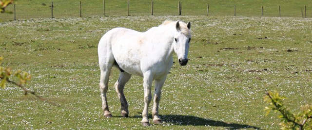
The landscape is dotted with cattle and sheep. But in one field, just for a change, I come across a pretty white horse.
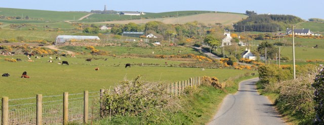
There are no real villages on my route, not until I get to Leswalt, just a few major farms, the odd smallholding, and an occasional traditional cottage.

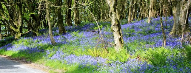
After several miles surrounded by open fields, I enter a shady strip of woodland. Here the bluebells are in full bloom. They won’t last much longer, but what a wonderful sight, especially when lit up by rays of sunshine slipping through the trees.
I’m startled by a loud barking and snarling. It’s coming from behind a fence, and I get my pole ready, half-expecting a pack of vicious collies to emerge. But some of the noise is being made by a Labrador. He’s not friendly and I’m glad we’re separated by a fence.

I keep an eye out for the other dogs – as there is clearly a group of them nearby, judging from the noise. A sign says “Peniglen Labradors”. Ah. A breeding centre? That explains the noise.
Further along the road, and the land on my left is a mess. Uprooted trunks and twisted branches lie in a semi-charred mass, and my nose is filled with the smell of old ashes.

Have they been clearing gorse bushes? I hope they haven’t destroyed a patch of proper woodland.
I reach a fork in the road. Although the right turn would take me straight to Leswalt, I’m going to turn left and continue further north for a few miles. Why? Because I’m trying to stick to my rule number two and the left fork takes me closer to coast.

Perhaps I really could walk along the shore? Perhaps I should have tried? This thought haunts me during the many hours of road-walking I do today. If only I was braver, I might risk it – but the fields are covered in cattle – and, to be honest, I’ve had enough of being terrified. This walk is supposed to be fun!
In fact, I can see the sea, just a mile or so away.
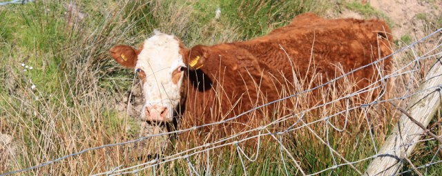
And I can also see plenty of evidence of my enemy – cows. Most of them have young calves too. Although this old moo doesn’t look nasty. Quite friendly really… maybe a little too friendly!
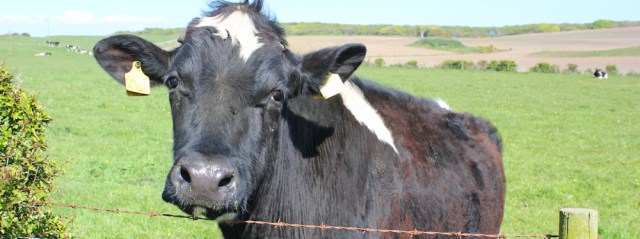
Yes, cows are everywhere. I hadn’t anticipated finding so many in Scotland.

Far out to sea is a ship, pale in the midday haze. A ferry. Must be going to Ireland from the Stranraer ferry port. I think of my old friends who left from the port this morning, and whose company I enjoyed yesterday evening – and I feel an unusual twinge of loneliness.
This is my fourteenth consecutive day of walking. I’ve got one more day planned tomorrow and, after that… well, perhaps it’s time to go home.
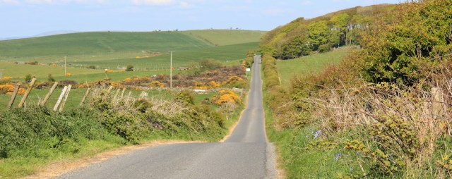
Onwards. This road goes on, and on, and on.
I come to the next turn to Leswalt. It’s the route I need to take.
Sadly, from here I know I’m going to be walking over 3 miles in the wrong direction. Wasted walking! But it was the best plan I could make given the infrequent/non-existent bus routes in this part of the country.
My road meanders up and down. Fields, gorse hedges and more fields. A line of telegraph poles.
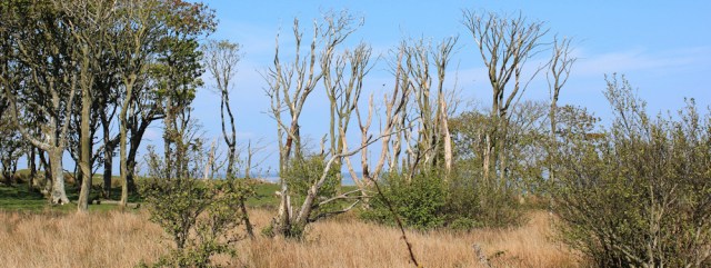
Here’s something different. A copse of dead trees. (Perhaps I should call that a corpse of dead trees?) Wonder what killed them.
Down a hill and into a valley. This must be Glengyre, I think, and with almost enough houses to counts as a proper village. And what’s that on the hill over there? A pillar or a tower? I check my map. A monument.
A cow bellows loudly. Close by. I swing round, but at first I don’t see where the noise is coming from, until I spot the beast in the ditch below me. Silly moo.
I pass an untidy farmyard, and then a little white cottage… but what’s that smell? Poo. What a stench! It’s coming from a pile of stinking manure rotting in a field nearby.
I feel sorry for the people who live here. Why dump a slurry heap so close to the cottage? Maybe the farmer hates them.

I pass close to the monument, which was built in honour of a local 19th-century MP. It’s also the site of an ancient hill fort – but I’m too tired to go and explore. Perhaps I’ll check it out tomorrow.
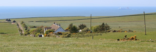
The road has taken me right across the central part of The Rhins peninsula and now I can look down on the water to the east. Loch Ryan. A sea loch. On the opposite side of the loch is the ferry port, while immediately below me is Leswalt. I’m nearly there.

It’s been a long and frustrating walk today. I always feel irritated when I can’t walk close to the sea and today, perhaps, I feel I’m cheating too – because maybe I didn’t try hard enough to follow the coast.
Ah well. Sadly, I’ve got another road-walking day tomorrow… better get some rest.
Miles walked today = 15 miles
Total distance around UK coast = 3,370 miles
Route


I’m pretty sure every town in Scotland has a golf course. Certainly I’m struggling to remember any I’ve been to that don;t! You have probably noticed, but lighthouse in Scotland are not owned by Trinity House but another organisation. So rather than white and blue/green as in England in Scotland they are white and light yellow as this one was.
I expect it is a relief to be on a proper long distance trail, albeit only briefly. I often battle with the “should I try to walk right along the cliffs/coast” question when there isn;t a proper path. Sometimes I’ve tried and regretted it, other times I haven’t and stuck to roads and sometimes I’ve found a proper path, unmarked on any maps.
I tend to look for a possible path and plan an escape route if I can’t find one (usually cut across fields to the nearest road), but sometimes when energy is low I just stick to the road or the nearest path I can find on the map.
This is a long trip. I don’t think I’ve done more than 1 week at a time since I started.
Hi Jon. Yes, I’d noticed the lighthouses in Scotland weren’t attached to Trinity House, but I hadn’t realised the significance of the different colour combination. Interesting.
Walking the coast certainly isn’t straightforward and this walk was long enough already, so I couldn’t really afford lengthy diversions. In retrospect, I wish I’d tried. But then… maybe I would have faced an impassable fence or a herd of angry cows? Eeek.
Hi Ruth, the “Coastal Interpretation Centre” housed the telephone and telegraph cables between Scotland and Ireland.
Shame you could not get further up the coast, which is probably the best bit of The Rhins. A deer fence and some seriously high vegetation and umpteen fences were the only obstacles and thne cattle were not particularly interested in me.
Off to Knapdale in the morning for three more days of walking.
Ah. Thanks Alan. That explains the strange wording and the dilapidated state of those little huts. I’m sorry I didn’t make it further along the coast too. Seems I missed a beautiful section of walking. Although deer fences and high vegetation sound like serious challenges – so maybe not… 😀
Hi Ruth – please excuse my slight cheekiness in writing this note. I have recently self published a whole load more of my books on Amazon under the title ‘Recollections Of A Coastal Walker’. I have now published 14 books in all although I will be re-publishing the first volume later this year to include maps. All the other volumes now have maps. So my books now cover Rye to Ardgour and so are up to date to the end of 2016. The books have been kept deliberately short so that each one only covers small sections of coast that may be of interest. I hope that maybe some of your readers might find them interesting. All the best Chris. PS If you object to this comment then please delete it and apologies from me.
This is really useful, thank you Chris. I’m sure there are plenty of people who will enjoy browsing your books – either other current coastal walkers or the legions of armchair hikers who enjoy reading about other people’s walks!
I assume you publish under the name of Richard Whiting? http://tinyurl.com/y72yh7vu
Richard F Whiting now. Many thanks.
The coast is certainly beautiful and it is a shame you couldn’t do more of this walk closer to it – I quite understand though; avoiding the pesky cows is a necessary precaution when you’ve had so many bad experiences.
Well you may have been concerned about it but I think you made the right choice to stick to the roads. From the car park where the Southern Upland Way turns inland the information board showed an onward route right along the coast called The Rhins Coastal path. So obviously I tried to follow it. Initially good but soon a very steep and tricky descent to a beach. Then a very steep route up again a few metres later. More rock climbing than walking. Then another down so steep I decided it was too dangerous more vertical so I turned back.
On the way back I spotted another turning off that went right to the cliff top. Perhaps I was supposed to go that way. Soon another very steep climb, a hands needed job then a sort of path along the top which soon disappeared. I climbed two fences then found no onward way at the most coastal route so headed further inland tons locked gate. I climbed this and found a promising looking path but unfortunately it emerged into a private garden of a house. Back up I eventually managed to climb the fence onto their access road and follow this to the public road. An exhausting hour to get less than a mile up the coast. So at that point I gave up and stuck to the roads, the same way as you. I did walk out to the lighthouse and back though.
Now back at the hotel I find this. https://dgtrails.org/rhins-of-galloway-path/development/ So it’s a planned path but mostly not yet finished. If it comes to fruition I hope to come back. The bits of coast you can get to are lovely so it would be a good path.