
Having spent most of the morning finishing off yesterday’s walk, it’s time to turn my attention to today’s trek.
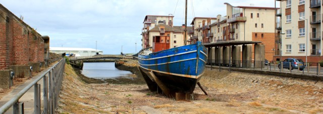
I walk past a newly developed residential area. Modern apartment blocks leer above an old dock, where a lone wooden boat is propped upright on the dry earth. The only remnant of a fleet, maybe? It stands defiant.
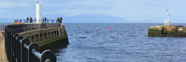
I reach the river and turn left to walk along the pier. There’s a collection of sightseers around the lighthouse on the end. On the other side of the water is a second pier, with another lighthouse. The two piers frame the Isle of Arran between them.
I sit on a mooring bollard and eat a snack lunch, admiring the view, before turning back.
Now I must walk up the river a short distance to find the nearest bridge. My side of the River Ayr is lined by the newly built apartment blocks.

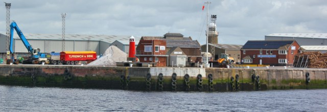
On the other side of the river, in contrast, is a working dock. I’m used to coming across abandoned wharfs and disused moorings and I hadn’t expected to see so much thriving industry in Ayr. It cheers me up. And another couple of lighthouses too – a tall one with a white top, and a striking, red, pencil-shaped one. Miniature. Like a toy.
I can’t continue beside the river, as the walkway in front of the new residential blocks is, apparently, private. (Shame. Why isn’t the river bank treated as a public amenity and why do the planning authorities allow this? I’ve come across the same problem several times in England too.)

Of course, I can’t resist taking a photograph of the “private” walkway. I would have continued along it, if I wasn’t worried about coming across a dead-end. There’s a nice view ahead.

On the other side of the river is a small marina.

I walk along the road until I reach the bridge and cross over, stopping to take a photograph looking back towards the mouth of the River Ayr and the distant hump of the Isle of Arran.

The official Ayrshire Coastal path continues along the road, but I head down the other side of the river, and through a rather ugly mix of rundown housing, storage yards, car dealers, scrap merchants, building suppliers, and mysterious workshops.
I skirt the edge of the dock area, and find a road that rises up to take me up and over the railway line. It’s not very scenic…

…and I wonder if I’m heading the right way… but a nearby sign tells me I’ve rejoined the Ayrshire Coastal Path.
Over the railway, and the road curves around towards another industrial yard. A cluttered truck rattles past, green pipes strapped on top, bouncing alarmingly.
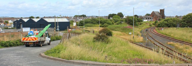
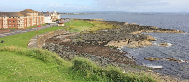
The industrial yard turns out to be a massive recycling centre. I walk down the side of the complex and reach the sea. Good. But, although it’s great to be back on the seashore, the view isn’t very promising.
Areas like this – semi-derelict wastelands – always make me feel uneasy. Why such a wide road? What are those parked cars doing over here? Why is that white van loitering over there?
In full walking kit, with rucksack, pole and boots, and my camera in my hand, I stick out like a sore thumb.
The parked cars turn out to be driven by dog walkers, nothing nefarious is going on, and I soon reach the end of the industrial zone and the end of the roadway. Here is a nice gravel path. Oh, and some other walkers too.

A plane flies low overhead. I remember the next place along the coast is Prestwick, and Prestwick has an airport.

[Once my husband and I went to Glasgow for a weekend break. We decided to fly to save travelling time. This plan wasn’t entirely successful as the plane didn’t actually land in Glasgow, but in Prestwick airport, almost an hour’s drive away!]
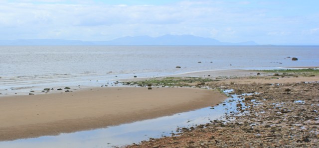
The beach to my left is a mix of sand and shingly rocks. I’ve lost sight of Ailsa Craig – haven’t seen it for several days now – but the Isle of Arran is a constant companion.
The path is lined with grasses and flowers. Pretty but, oh dear, (sniff) not so good for my hay fever (sneeze).

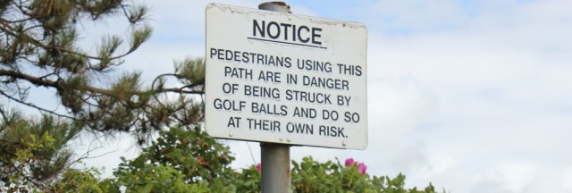
There’s a golf course on my right. St Nicholas. And the usual silly signs.
I’m getting closer to Prestwick and there are more people about. A family appear to have abandoned their cycles. It’s always reassuring to be in an area where people don’t bother to lock up their bikes!

Ah, there’s the family, I think. They’re peering into rock pools and one of the children starts shrieking. A crab!

The beach is wider here. A lone woman dog-walker strolls near the waves. Someone has written the letters ‘Natalie’ on the sand.

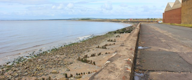
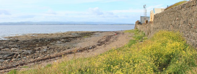
I expect Prestwick to be a big place, but the seaside part of the town is surprisingly small. Pleasant enough, but with a slightly battered esplanade, whether due to lack of maintenance or due to severe winter storms is hard to tell.

Beyond the houses, the esplanade continues for a while and then fizzles out. The strange hut at the end is not a café (disappointing, because walking really does make you hungry!). Turns out to be a water treatment centre.

From here onwards, I walk along the beach.
Acres of sand and gleaming pools of water. The light bright in my eyes. I walk past gulls and try to sneak up on a heron standing on a sandbank, until he sees me, lumbers slowly into the air, and flaps away towards the waves.

According to my map, about half a mile ahead is a little river – Pow Burn – which interrupts the beach. Before I reach the river, the Ayrshire Coastal Path turns inland, meandering over the dunes and through a holiday park, where I can cross the little burn via a bridge.
But I can’t see any sign of a river. Perhaps it has dried up? Or split into a myriad of tiny streams? So I decide to carry on along the beach.
I’m not entirely alone. A few distant specks of people are visible far ahead. But… so much sand and open space… almost makes me giddy.

The river does exist. I don’t spot it until I’m only a few yards away. It’s almost invisible because it runs narrow and low between sandy banks. Fast flowing. I walk beside the stream towards the incoming waves, where the the water becomes relatively shallow. But it’s still deep enough to overtop my boots.
Time for a paddle. Off come my boots and socks, and I wade across with ease. The water is cool around my feet, but not shockingly cold. Just one problem… I forget to roll up my trousers, and so end up with wet legs!
Another couple nearby seem inspired by my example, and wade across too. They, very sensibly, have rolled up their jeans.
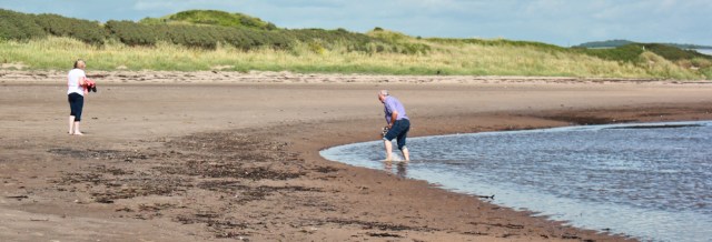
Onwards. I walk barefoot, dangling my boots by their laces. The breeze soon dries my walking trousers.
The tide is coming in. Silver lines of waves sneak across the rippled sand. I send oyster catchers scattering and chattering, and disturb groups of black-headed gulls.

Eventually, I begin to run out of beach. I cross an area where rocky outcrops spread across the sands – Meikle Craigs, Black Rocks, Little Craigs, Wading Rocks. I pick my way through and am back on sand again.
South Bay. There’s Troon ahead. I must have been walking past the famous Royal Troon Golf Course, but haven’t seen much of it as I’ve been sticking close to the sea.
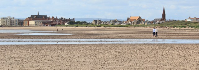
I stop to put on my boots and turn back to look along the bay. Ah, the tide is really coming in now. But what a perfect curve of beach.
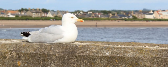
I walk through a park and take a photograph of a herring gull sitting on a wall. I’m not too keen on herring gulls, but this one looks positively regal.
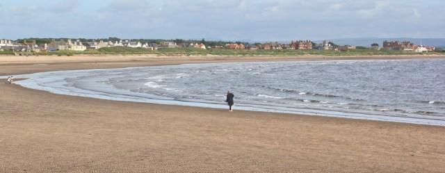
There’s a knuckle of land that sticks out from the coast at Troon, and this knuckle divides the shore into two distinct areas. South Bay and North Sands. I follow the path up and onto this headland, then stop to take a photo looking back towards South Bay. The tide is really in now. More water than sand.
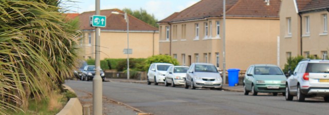
I’m walking along the flat top of a tall grassy bank. Below the bank, to my right, are rows of houses. Looks like a council estate. Nice place to live, I think, until I realise if you’re down in one of those houses you won’t be able to see the views!

I can’t decide if the bank is natural or manmade. Or a bit of both. It’s nearly 5pm. I stop and sit on one of the benches and have a drink and a snack.
A little further on, I find one of those compasses pointing out the distance to various landmarks. The Heads of Ayr, where I started my walk this morning, is only 8 miles away.
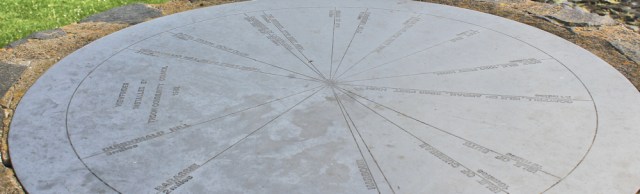
Only 8 miles! I must have walked further than that.
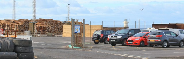
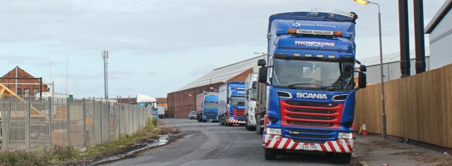
To my right, the housing estate has given way to another industrial estate. This one seems to consist of a giant sawmill. From the vantage point of the high bank, you can see exactly how it operates. Everything automated and on a huge scale. Fascinating.
Here is a huge lorry, half empty now, and a red crane has been lifting logs from the flatbed and placing them on a moving blue escalator. The logs tumble together, rotating gently, as they are carried slowly along the conveyor and disappear inside the building.

I can’t see what happens inside, but the results are obvious. A little further along are a couple of chutes, carrying a constant stream of stuff, which they deposit in growing heaps. One is churning out great splinters of wood, like oversized matchsticks. The other is churning out bark.

Inside, and invisible to me, the stripped and straightened logs are being cut up into planks. I can’t see the planks emerging, but I do see them stacked and waiting for shipment. Hundreds of them. No – thousands of them!

My father-in-law was a joiner and had a timber yard. Nothing on the scale of this.
I could have stood for much longer watching the saw mill at work, but it’s time to continue my walk. Not far to go now, but the last part of any walk is always the longest… and the hardest.
Disappointingly, I realise I can’t make it to the tip of the knuckle because the end section is walled off. (I know I could have walked further down along the shore, but it’s only a dead-end and, to be honest, I’m feeling too tired.)
The reason you can’t reach the tip? There’s a port in the way. Guess what they export?
I walk up the other side of the knuckle, along the road. It’s not very pleasant. Not much traffic, but clearly not a place designed for pedestrians. The pavement is narrow and strewn with litter. I must have lost the Ayrshire Coastal Path. This can’t be it.
A string of lorries are parked up alongside the timber mill. Are they waiting to load up or unload? Or just resting before the journey home?
I leave the timber mill behind and reach the residential area – the one I was looking down on from the bank earlier. Ah! There’s a coastal path sign. I really am on the right track after all.
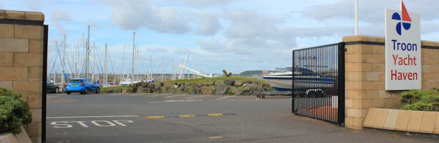
To my right are houses. To my left is an odd assortment of yards, industry, and… a marina. Troon Yacht Haven.
The big gates are rather off-putting and the wall is too high to see over, so I only get a distant impression of clusters of masts. Shame. A proper view of the marina would have cheered up this final section of my walk.
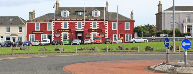
I emerge on a road and continue following the line of the shore. There’s a collection of enticing looking pubs across a green area… oh, it would be nice to stop for a cool cider and a rest . But if I sit down, I might never get going again, and I need to catch the train back to Ayr.
It’s time to head inland, into the town, to find the station.
Miles walked today = 16.5 miles (not 8 miles as the compass suggested!)
Total around coast = 3,467 miles
Route: Red line is this mornings walk. Black line is this afternoon’s.


‘…..the last part of any walk is always the longest… and the hardest”
How very true!!!
Loving your blog. Congrats and keep going!!!
Thank you. And I will 😀
I know that sense of apprehension in semi-derelict areas, especially when white vans are parked up, but at least there is space there for nature to begin a take-over, unlike the new waterfront apartment blocks with their manicured private walks directly on the shore – I agree, it should be obligatory to leave a strip for a public path and wild flowers. Semi-dereliction is often rather lovely – unless you suffer hay fever, of course. This looks to have been an interestingly varied walk from wide open spaces of the beach to busy sawmill and ‘posh’ marina. Pity you’d no time for the glass of cider, though.
The only time I really feel uneasy, Jacquie, is when I walk on the edge of industrial estates along semi-deserted roads where people are parked for apparently no good reason. Give me a lonely stretch of coastline… and I’m fine!
Hi Ruth, I too was amazed at the size of that wood processing yard. I’m afraid the omnipresence of McFadyens and McKerralls log hauling lorries will be with you as far as Oban and beyond.
I didn’t realise there would be so much industry up here, Alan. But pleased to see a successful enterprise, and fascinating to watch the plant in action.
A long walk but not one of your prettiest Ruth! Hope the next section is less industrial for you.
Hi Gillian. Yes, you have to take the rough with the smooth, but there’s always something interesting to see.
I love the name Troon so very Scottish sounding (especially if you think of someone saying it an a broad accent and rolling their Rs!). I nornally try to hurry through industrial areas but that wood processing place actually does look quite interesting. Not sure whether the Scottish “right to roam” would “trump” those Private signs near the flats. I know the right to roam does not extend to gardens but I doubt a tarmac path in front of some flats could be considered a garden.
I don’t mind industrial areas, as long as the walking evironment isn’t too intimidating and there are interesting things to look at. Always think they should have information signs up (like they do with wildlife sites or historical sites), e.g. this is a working sawmill and deals with xxx thousand logs a day, etc.
Am in the process of catching up with your travels as have been super busy this summer. You are certainly hacking away at the miles and makes me yearn to get back out there (hopefully Oct/Nov). Love the regular pics of the Isle of Arran and Ailsa Craig – so comforting to have them out there almost as if they’re following you to keep an eye on your progress.
Hi Nancy (or Babs- I’m never sure!) yes, I get very attached to landmarks in the landscape, and always feel a twinge of sadness when I leave a familiar companion behind. I think Ailsa Craig will be with me, off and on, for some time now. 😁
Nancy!
😆
Such a shame that new homes mean that the public can no longer walk along the path. Someone near me managed to get a public right of way changed to a private road when some new homes were built which meant a detour along the main road to get access to the forest.
I did this walk on Sunday, I walked from Ayr to Stevenston. Like you I thought the area north of Ayr looked a bit dodgy too, the sort of place you might expect drug deals to be taking place! There was a man sat in a van smoking but I think everyone else was dog walking.
Some lovely beaches on this stretch too. Both Troon and Irvine were nice than I expected. The pavement past the harbour in Troon has been re-laid now with prominent signs warning lorries not to park on it (hopefully they stick to it, there weren’t any for me but then it was Sunday). My map (newly bought) still showed a ferry service from Troon to Larne, but I think it’s many years since that ran!