
I’m lost in the woods!
I know that if I follow the same paths I took before, I’ll end up going round in a circle again. So instead of following the “long route”, I follow the “short route”.

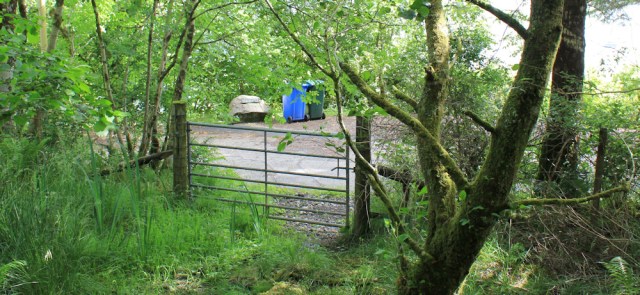
This turns out to be not so easy, as the route soon branches into multiple paths and it’s not clear which one to follow. I decide to keep going downward, and scramble down a steep slope, clinging onto tree trunks to keep myself upright.
Ah, there’s a gate ahead… and there’s the coast road. Hurray!
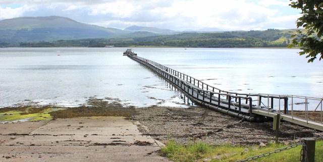
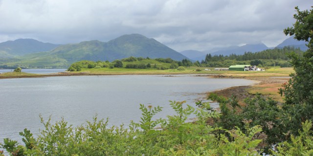
I follow the road to the end, where there’s a cottage and a slipway. I stand by the slipway and look out over the mouth of Loch Creran. I just can’t get over how beautiful Scotland is.

Then I turn back, and follow the coastal road back towards Benderloch. The woods are now on my right, but on either side of the road is a mixture of old cottages, and some modern houses. This one is still under construction. Very nice. And with a fantastic view overlooking the water.

It would be a perfect area for smart residences, if it wasn’t for the industrial yards, the parked haulage lorries, and a collection of strange green tanks.

Of course. It’s another fish farm!
I walk past a very long pier, that seems to carry some sort of conveyor belt. Is it for collecting fish from the fishing boats? I think it must be.
I leave the fish farm behind, and now I am walking close to the shore.

There are some black bullocks grazing in a nearby field. Aberdeen Angus, I think. Despite the dull weather, the view inland is truly dramatic. I stop and take photographs.

The coast road turns inland, and takes me back to the crossroads. Here’s a sign I noticed earlier. Barcaldine Castle. Good, I’m looking forward to clambering around the ruins and, maybe, I’ll find somewhere nice to sit and eat my snacks.

But Barcaldine Castle turns out to be a rather posh B&B holiday place. No ruins to clamber around. And nowhere to sit and eat.

I perch on a grassy verge further down the road, overlooking a field of cows, and eat a cereal bar and some biscuits. It’s only 11am, but I’ve been walking for 4 hours and I’m hungry!
Onwards, down the road, past farmland with sheep, a pony park, and then a residential area…

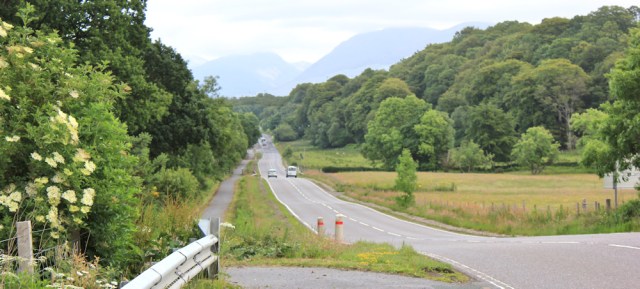
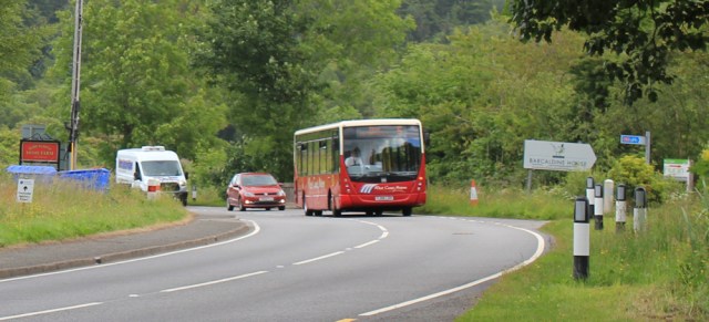
… until I reach the main road – the busy A828. Actually, the traffic isn’t too busy, it’s just that everything hurtles along at 90 mph.

I haven’t been looking to this section of today’s walk, but luckily there is an excellent cycle/walking path running alongside the road.
A sign tells me this is National Cycle Route 78, a joint enterprise between the Scottish Government and Sustrans, to encourage walking and cycling.

Sadly, there appears to be a total absence of both cyclists and walkers on this stretch of the route. It all seems fairly new. There are even road markings for the cyclists.

The track closely follows the road, sometimes running alongside the main carriageway, and sometimes screened by bushes – which makes for far more pleasant walking.
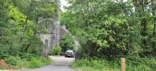
I walk past a church, and check my OS map, but no church is shown on the map. There are no signs either. Weird. I wonder if the building is now a private residence?
I get occasional glimpses over Loch Creran. Beautiful.
There’s a turnoff to a farm a B&B place and a pottery. I’m tempted to stop and look at the pots, but I’m hoping to walk a good few more miles today, and I decide to carry on.

The cycle way is marked by ornate gates. Love them.

A symbol tells me I’m on The Caledonia Way. Oh. Is that a walking route or a cycling route, or both?

[Later I discover that Route 78 is the Caledonia Way, and it’s a 237 mile cycling route running from Campbell Town to Inverness. Strangely, I’ve walked up the coast from Campbell town, and can’t remember seeing signs for The Caledonia Way before.]
I meet my first cyclist. As usual, I think of my husband. He would enjoy this.

I reach a car park for the nearby Sea Life Centre. The cycle way is also the access route to the centre, and a minibus crawls slowly away.

There are advertising signs for the Sea Life Centre all along the access road. I like this one. “Have an otterly good time.” Makes me smile.

The access road soon swings away from the cycle path to join the main road. Now I’m walking through a pleasant area of woodland, slightly above the road.

I spot something bright among the grasses of the verge. Red berries? Ah, wild strawberries! How wonderful. I stop and pick some.

I’ve just read a book about a woman who walked the entire length of the Appalachian Trail in 1955. She carried very little in the way of supplies, and ate fruit and wild berries she found along the route. These strawberries are very tasty, but I wouldn’t like to rely on them as a food source.
Onwards. The cycle path crosses over the road…

… and soon joins a track. I’ve reached the village of Barcaldine.

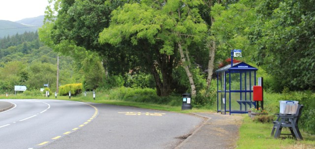
I was going to continue further. But I’m suddenly overcome by a feeling of fatigue. The next bus stop is 4 miles away, at a place called Appin, and beyond Barcaldine the service is very infrequent.
The bus stop nearby looks so very, very inviting. And, look, it even has some comfortable seats nearby.
But the seats aren’t for sitting on. They’re actually the support for a makeshift book exchange. What a great idea!
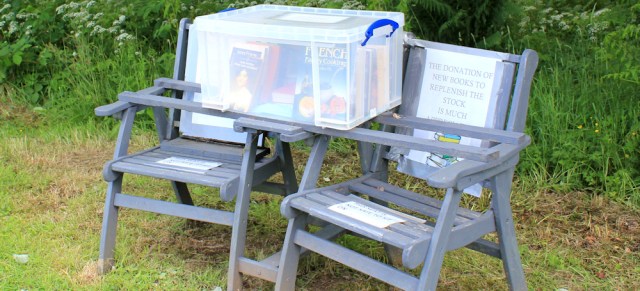
I’ve seen an old, red telephone box used as a book exchange, back on the Kintyre peninsula, but this is the first time I’ve seen a couple of chairs used in this way.
Anyway, I decide to end my walk here. It’s always a leap of faith, waiting by a bus stop, with nobody else around, but there should be a bus arriving in the next 20 minutes.
I wait. And wait. And wait some more. Ah, there it is!
I return to Benderloch and find a café that does hot food all day. Yay! Then I drive The Beast up the narrow road to the car park for Shian Wood.
The car park is empty. The sun is shining. And, best of all, there’s not a midge in sight. What a wonderful place to spend the night! So quiet and peaceful. Just the occasional car driving past on its way to Eriska Island.
I spend the rest of the afternoon sitting in my chair, enjoying the view, reading a book, and drinking a large bottle of cider.

I’m woken just before midnight by somebody rustling a nearby bush. Oh no! Is someone going to attack me and my van? I grab a walking pole and peer out through the curtains.
It’s only a deer.
The lady who walked the Appalachian Trail in 1955 was Emma Gatewood, and the book about her adventures can be found here: Grandma Gatewood’s Walk
Miles walked today = 10 miles
Total distance around coast = 3,886 miles
Route: (black=morning, red=afternoon)


Hi Ruth, I sat on the very same eerge to have a quick bite and change of footwear
Aha! A good spot 😀
“verge” i meant to type
Glad you made it out of the wood OK. I also ended up going round in a circle in woodland on a coastal walk in Scotland a couple of months ago, so it’s not just you (It was at Kirconnel Flow and I never did find the path I was meant to take so gave up and took the road).
I share your frustration about that castle too (I love a good castle). It has a brown tourist sign with the Visit Scotland logo so if it’s a B&B then the sign is wrong (I know hotels and B&B sometimes also get the brown signs, but then they are marked with a bed symbol, not a tourist attraction symbol).
Fish farms seem to be sometihng you see a lot of on the west coast of Scotland. I don’t recall passing any on the east coast but although I’ve only done a little of the west cosst, I’ve come across a lot of fish farms already
Glad that busy road had a cycle path, it’s always a relief when dreading a bit of main road walking to find there is a pavement or cycle path after all!
You’re right. The sign was very misleading. Only later, looking at the photograph, did I realise it had a small B&B sign tacked onto the bottom. Maybe you could look round it, if you went and asked, but there was nothing that seemed to invite casual visitors.
Fish farms are everywhere, on the west coast.
What a gorgeous place to spend the night – with a view like that I don’t think I’d want to leave 🙂
It was fabulous, Eunice. But I found some even better ones later!
Thanks for the ‘Grandma’ link (and much else besides…).
She makes my hiking adventures look like a stroll in the park 😀
You might be interested to know that the reason there’s a slipway at the end of the road at South Shian is because up until 1948 there was a ferry across Loch Creran to North Shian on the other side.
Ah, I wondered if there might have been. Interestingly, a couple are walking the coast and ‘pretending’ to use any ferry crossing they come across, including historic ones. So they could have used this one.
The cycle path follows what used to be the railway line from Oban to Fort William and offers splendid views. Appin features of course in the book Kidnapped. Very good walking country.
Hi John. Interesting. I didn’t know about Appin and Kidnapped. I read the book as a teenager, but can’t remember much about it. Will have to dig it out again.
Hi Ruth, especially loving your Scottish journey as I have a huge passion for the highlands myself. It’s a beauty that has been drawing my husband and I back for years. I’m fascinated by how you’re navigating the coast, it really can’t be easy planning your route. It’s an incredible place isn’t it? Sometimes I find the views are so breathtaking they make me fill up with tears. The good news you’ve got so much more of that to come because and in my opinion it just keeps on getting better the more north you go. I can’t wait to see more of your beautiful pictures and read more of your wonderful account. Looks like you’ve been blessed with the weather too thankfully 😊
Thank you Di. Everyone says how beautiful Scotland is, but you really have to be there to appreciate it, don’t you. Interestingly, during this lovely hot summer, there have been a lot of foreign tourists here – Japanese, Chinese, European – but relatively few English people. And, of course, absolutely everywhere was fully booked. Glad I’ve got my van.
I never realized there is an original Barcaldine. There is another near the tropic of Capricorn in Australia. As well as being the home of the Labor movement in Oz, Barcy is famous for how many pubs have caught fire over the years. It looks nothing like the Scottish version.
http://ratbagp.blogspot.com/2010/08/barcaldine.html
ray
Ha ha, it sounds far more exciting! 😀
I read that Barcaldine in Australia was named by a Scot who started a sheep station there in the 1860’s. Named for his home in Ayrshire which in turn had been named after “our”Barcaldine.
I love hearing about Grandma Gatewood. As I recall she hiked the whole AT in sneakers and didn’t even sleep in a tent. Amazing! I love following your blog. I read it with my Michelin Atlas of Great Britain by my side so I can see where you are.
She was amazing, and walked the AT twice! You’re right, she didn’t carry a tent, but she often just sat down on peoples porches, and waited for them to offer her food and accommodation. I guess you can get away with that as an elderly woman 😄
I love your final photo. There is a joy in just chilling for an afternoon with the van nearby when the kettle is required!
Yes. Sometimes it’s good just to relax and enjoy a place. However, I’m ashamed to admit I was drinking cider, not tea. 😆
I have zero sense of direction and sometimes think I shouldn’t be allowed out on my own! I have a friend who always knows which direction north is and she can’t understand why I don’t – and I don’t understand how she does!
We have a magnetic chemical In our bodies, called magnetite. I think there’s a layer at the back of our eyes, and in other parts of our brain too, In some animals, it seems this magnetite can help in navigating – pigeons, for example – and possibly cows use it to line up because they usually face north while grazing. It’s possible that we humans, or some of us – like your friend – have some magnetic perception too, Just a theory at the moment, but an interesting one,
That is fascinating Ruth, and not something I was aware of. Now I know how homing pigeons do what they do – and also why at some point I picked up that cows know where north is!
I mostly followed your route but the other way. I was able to drop down onto the shore at the fish farm and make my way, with a bit of difficulty to the Eriska bridge and couldn’t resist visiting and walking round that. I had originally intended to just connect the roads up and try to avoid the woodland where you went in circles, but got sidetracked! When returning from Eriska I passed the gate posts for the hotel. They made it look very private but fortunately no signs saying private the way I came and no one questioned me. The rest of the walk was the same, I used the same bus stop too but on the other side of the road. The book exchange is still there but in a more permanent wooden structure now. Looked a bit like a rabbit hutch!
Oh yes sadly the Sea Life centre has closed down and is boarded up and fenced off. I found that it closed on 31st October 2018, not long after you walked here it seems.