
[This walk took place on the 7th July 2019]
I spent last night in a camp site at Shiel Bridge. This morning, I face a 12 mile ride over the Ratagan pass on my Scooty bike, a steep climb which just gets steeper and steeper. Eventually the incline defeats me – even with full electrical assistance – and I must get off and push the bike up the final 1/2 mile.
Arrive at the top in a bad mood. Sweaty and tired. THIS wasn’t what I bargained for when I swapped my heavy Monster for my even heavier Scooty. But from here onwards things can only get better (or so I think).
As soon as the road begins to slope downhill, I hop on the bike and it’s a cool glide down Glen More, through Glenelg, and back to the Kylerhea ferry terminal. I leave Scooty chained up behind the ferry café (which is still closed).
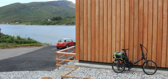
I’m exhausted by the ride – both from the effort of pushing such a heavy load up the steep hill, and then from the surge of adrenaline as I sped downwards – so I sit on a bench outside the café for a while, and watch the seals playing in the water.
It’s a beautiful sunny day. Hard to believe I nearly turned back when I arrived in Glenelg a couple of days ago, miserable and anxious because of the torrential rain and fierce winds.
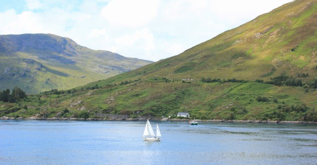
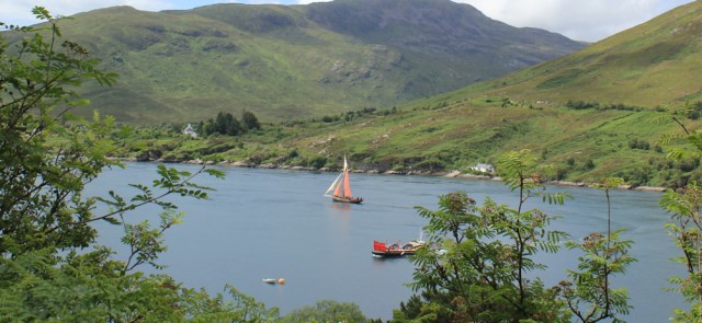
A loud blaring noise disturbs the peace. The Kylerhea ferry is making a crossing, and hoots to warn a sailing ship to watch out. I think engine-driven boats are supposed to give way to sail, but I wouldn’t like to argue the point with the ferry.
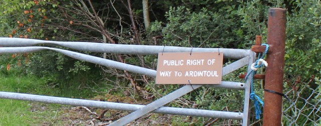
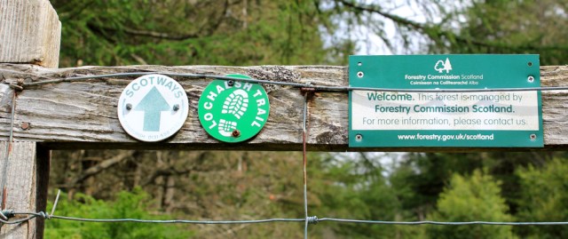
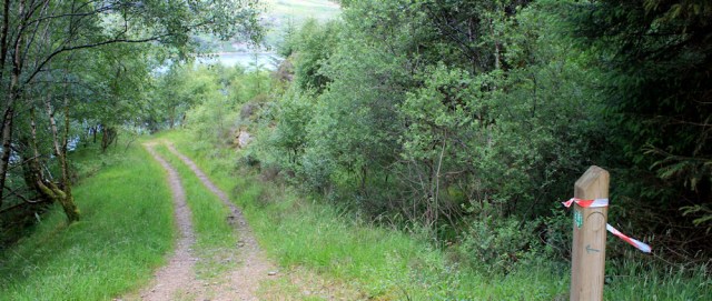
It’s gone midday by the time I set off on my walk. I’ve been worrying about today. It’s a long walk back to Shiel Bridge, and I’m already tired. But, the sign on the gate is encouraging: “Public Right of Way to Ardintoul.”
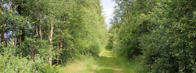
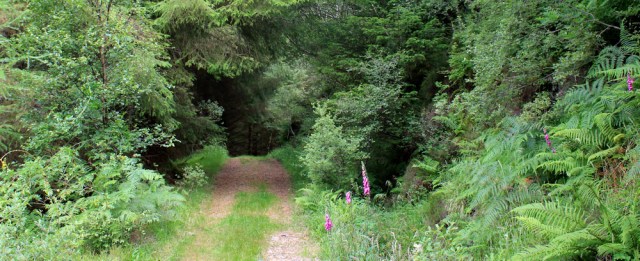
I follow a pleasant green lane, climbing slowly uphill. Shame I can’t see the shore because of the trees.
Through gaps in the foliage, I get occasional glimpses of the water. There’s the ferry, and I hear another hoot, because there’s another sailing boat passing through the narrow stretch of water between Skye and the Glenelg peninsula.
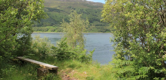
I pass through another gate, and the grassy lane continues. Would love to stop and sit on this bench, but it’s too soon for another rest. Onwards.
Now I pass through a deer fence, via a gate with helpful signs. This is a ScotWays path, and part of the Lochalsh Trail (which I’d never heard of before).
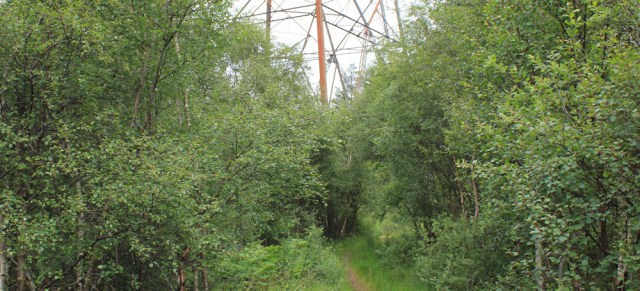
What a lovely trail, passing though a woodland of mixed broadleaf trees. I make rapid progress.
I even see a few encouraging footpath signs along the way – so rare in the Highlands – although some seem to be bandaged with red and white tape and marked with little blue arrows.
Incongruously, the path passes under the metalwork of a giant pylon. Must be carrying electricity over to the Isle of Skye.
Ah, this gets better and better. The track has dwindled to a path and now I’m walking along a ridge above the sea, surrounded by silver birches…
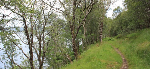
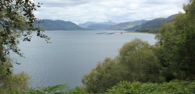
… and with great views over the water. I’ve nearly reached the end of the narrow channel known as Kyle Rhea, and the next expanse of water ahead is Loch Alsh.
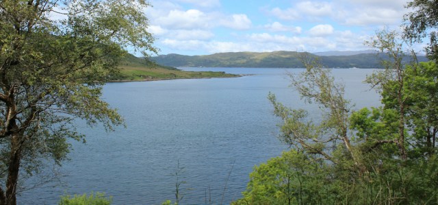
So far, my route has been in a northerly direction. Now the path curves round, and I’ve reached a point marked on my map as Garbhan Cosach. It seems a major milestone because from here I’ll be walking in a westerly direction and, by the end of today, I will have finished my trek around the Glenelg Peninsula.
Another great view opens up before me – all the way down Loch Alsh, with the distant mountains of Wester Ross as a backdrop.
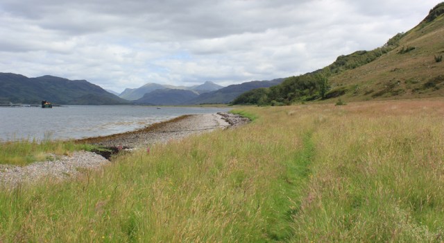
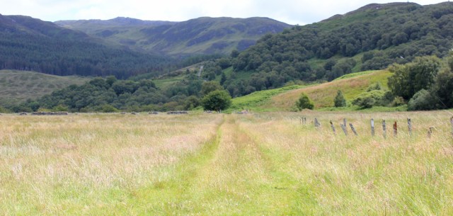
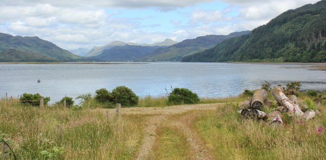
I walk above the water for a while, and then the path drops down to the shore, and I walk along a grassy path at the top of a shingle beach. To my right, the land slopes gently up towards a line of high hills.

After a while the landscape opens out. I stride through an area of flat grassland where, after the past few miles of woodland walking, I feel almost overwhelmed by the sense of space around me.
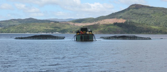
This side of Loch Alsh is wild and empty, but on the far shore I can see houses and settlements. And, of course, there is the obligatory fish farm set a few hundred yards out in the loch.
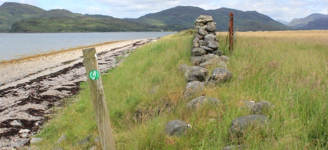
Approaching Ardintoul Point, my map suggests the path curves inland, but the route isn’t clear on the ground. The green footpath marker seems rather ambiguous as it has no directional arrows. I’m tempted to continue along the shore, but this is the first waypoint I’ve seen for some time, so I decide it must mark a significant junction.
I turn right and climb over some fallen stones and enter a wide, grassy field. Here I follow a vague track running beside an old fence.
At the far end of the field, I join a more defined track. Now, I have a choice of turning either right or left. Of course, I turn left, as this will take me closer to the shore,
(Note: for anyone else doing this route, the right thing to do here is turn right!)
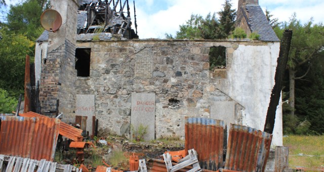
The track takes me past a ruined house. From the charred state of the roof, it might have been destroyed by a fire. I stop to take a number of photographs, as I love photographing old derelict buildings.
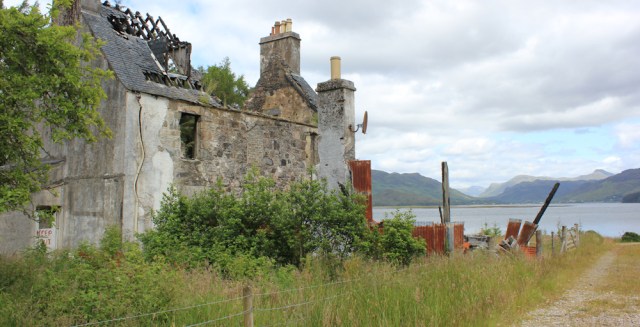
“Danger. Keep Out,” warn the signs. I wonder who used to live here, and where they live now. The place was abandoned not that long ago – it has a rusty satellite dish attached.
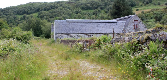
Beyond the building is a track that gives access to the fenced-off industrial yard that lies at the tip of Ardintoul Point. This yard is the reason I had to come inland, and might have something to do with the fish farm, but I wonder if I could have walked around via the beach anyway.
 Now I’m back on the edge of Loch Alsh, and turn right to follow the shore around Ardintoul Bay.
It’s a beautiful place, and I’m lucky to have found such a clearly marked route – the Lochalsh Trail. Some people said this section was difficult! Pfff! Nothing to it. I congratulate myself on making great progress.
[To be continued…]
Route so far today: Purple line is the bike ride, black line is the walk.


Ruth. As we approach year end in a few weeks time. Carol and I would really like to
Thank you for your excellent blog. Which we have used again this year as we make our way around the English coast… slowly!
All the very best
Paul
Thank you Paul. I know you and Carol have done parts of the Lincolnshire coast too, an area I haven’t covered yet. Hope you have many months of happy walking in the new year.
Hi Ruth – I can’t wait for your next post. When I walked this next stretch I used guidance notes from the ‘Dirty Thirty’ challenge (walk). I got lost in the forest even with these notes. How you managed it without any assistance is quite amazing. I can’t wait to read more of your exploits as it is one of the hardest stretches on the coast!!! (Unless you found an easier way!!!)
Ah, well it didn’t go as planned Chris!
Lovely scenery and views 🙂 That ruined house is just crying out to be explored and properly photographed – I think I would have been in there in spite of the ‘keep out’ warnings.
It was tempting Eunice 😀
Nice to hear about more of your walks. Looks like another beautiful walk and you’ve left us on a cliff-hanger again! As to the red and white tape I think that is sometimes done when there is a group walk or some sort of other event to make the route more obvious. Unfortunately the organisers of such events are not always so good at removing them again afterwards.
There do seem to be so many derelict old buildings in Scotland,especially on the coast. I see you’re not so far from Kyle of Lochalsh now. I’ll be staying there for my first two trips to the Highlands next year (already booked) though I’ve not yet reached that far south yet. I’ve finished at Lower DIabaig for this year, which is where I’ll be resuming from in the spring. I’ve done most of the Ayrshire coast though now, having been able to do that as a couple of weekens, being a bit closer than the highlands.
I can’t wait to get back up there. Weather forecast doesn’t look too bad next week in Torridon area, but the days are too short for my sort of walking (ie SLOW walking!). Maybe our paths will cross next spring!?
As to the significance of those red and white tapes, I didn’t discover what they meant until much, much later!
Looking forward to your next report then. Obviously you must have survived … but I’m wondering what problems you had!
My first trip to the highlands next year isn’t until Mid May unfortunately. With a full time job I don’t have the luxury of waiting for a period of nice weather, much as I’d like to be able to, sadly. So I aim for the more summery months when the days are longer to maximize my opportunities! Though I’m going back to the more southern parts of Scotland in March to make progress heading north from there too, as it takes less time to get to the highlands!
Can’t believe you cycled over that pass, even with an electric bike. Seriously impressed!
Hi Ruth – Great to hear more of your exploits and the scenery is amazing. (Strangely though whenever you mention that Scooty bike I keep getting images of a certain 1960’s -70.s yellow and black glove puppet chap !!!) Keep on keeping on and best wishes – Russ
Thank you Russ.
You cycled (albeit with assistance) over to Glenelg!! Respect 🙂 But I’m getting some worrying vibes about the next part of the day
What a wonderful scenic area. I seem to remember staying in a youth hostel at Kyle of Lochalsh more than 40 years ago – maybe nearer 50!