
[This walk was completed on the 7th Aug 2019]
I stand beside the village shop in Kishorn, and watch the minibus disappear down the road with a mix of excitement and trepidation. No backing out now. I’m committed to walking up the Applecross road, and over the infamous Bealach na Bà pass.

There is a red phone box beside the shop and it’s covered in bunting. A couple of signs proclaim this to be the “Kishorn Selfie Box”. Of course, I can’t resist investigating…
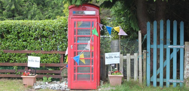
The Kishorn Selfie Box turns out to be exactly what it says on the tin – or, to be more accurate, on the box. Just a place where you can snap a selfie on your phone.
Here’s my selfie! Do I look slightly anxious?
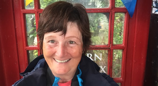
In fact, I’ve been worrying for weeks about how to tackle the road to Applecross. I knew the walk over the steep Bealach na Bà pass was going to be tough – and I doubted whether I could cycle back over the pass, even with the help of my Scooty bike.
So, I was delighted to discover that the garage in Lochcarron runs a private bus service between Applecross and Inverness. The bus passes through Kishorn, Lochcarron, and various other places. It goes the long way round, avoiding the steep pass, and the journey to Kishorn takes roughly 75 minutes. You have to book a seat in advance.
Trouble is, the bus only runs twice a week, on Wednesday and Saturday, and leaves Applecross at 8 o’clock in the morning. So, all my planning for this trip was based around the bus timetable.
Yesterday was Tuesday, and in the evening I drove round to Applecross the long way, and settled my van (aka The Beast) into a campsite for the night. This morning, I was so worried about missing the bus, I got to the pick-up point half an hour early. The bus stop was unmarked, of course, and I had an anxious wait – unsure if I was in the right place. Luckily, I was!
So, here I am, staring down the road. Worrying about the tough day of walking ahead.
Onwards. Leave the shop and the Kishorn Selfie Box behind, pass a nice-looking seafood cafe, and follow an old man down the road.
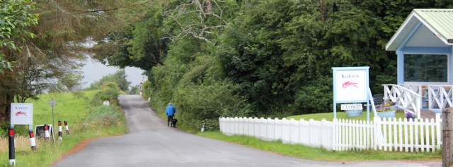
I soon come to the turn-off for Ardarroch and Achintraid. This is the point where I ended my walk yesterday. Today, I’m keeping straight on along the main road – heading towards those misty mountains, and the pass over to Applecross.
The mountains are shrouded in cloud, but suddenly a patch of sunlight breaks through, and a rainbow appears. Ah. Beautiful.

It’s a beacon of reassurance. A sign that everything today is going to be all right.
The main road (the A896) swings around to the right, following the shore, and starts heading up along the side of the River Kishorn. There is no pavement, but traffic is very light and I make rapid progress.

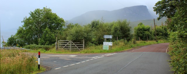
After a couple of miles, I should reach the turn-off for Applecross. Ah, there it is.

Usually, I avoid doing too much research in advance, because I like to see a place with fresh eyes. But, before tackling this section, I read up on the Bealach na Bà pass because I needed to know what to expect.
The best advice page was probably on the Applecross Inn’s site. Mainly aimed at car drivers, I found one particular piece of advice intriguing. “The sign at the bottom of the Bealach is an driver advisory sign… PLEASE do not deface this with stickers.”
Here is the sign. And now I understand what they mean about the stickers!

The warnings might be difficult to read, but the advice is still just about discernible and somewhat intimidating. I’m glad I didn’t try to drive The Beast up here yesterday.
Another sign tells me this is part of the Wester Ross Coastal Trail, and I know it’s part of the popular N500 route. When I turn down the road, I’m greeted by another warning sign.

It’s early August. I should be alright!
The road crosses over the River Kishorn via a bridge, bends sharply to the the left, and then slowly rises up the slope on the far side of the river.

I’ve seen warning signs about weight limits along the road, so I’m surprised when a huge lorry thunders past me. What? If that monster can get up here, so could my Beast!
But the lorry turns off along a side road, heading down to… I check the map… oh, yes, a salmon farm and a dock area – Kishorn Port. It’s not going up over the pass after all.
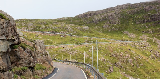
I reach the side turn. This is where the weight restrictions start. There are more warning signs about wintry conditions. Only 11 miles to Applecross. So far, so good.
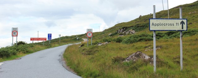
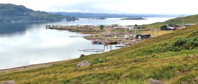
As the road climbs higher, I get a good view over the fish farm and dock area. Looks like quite a busy site. Strange to find bustling industry in such an isolated place.
Onwards. The gradient is steady and not too steep, and the clouds seem to be lifting. What was I worried about? This road is a piece of cake. Love that weirdly shaped hill ahead.

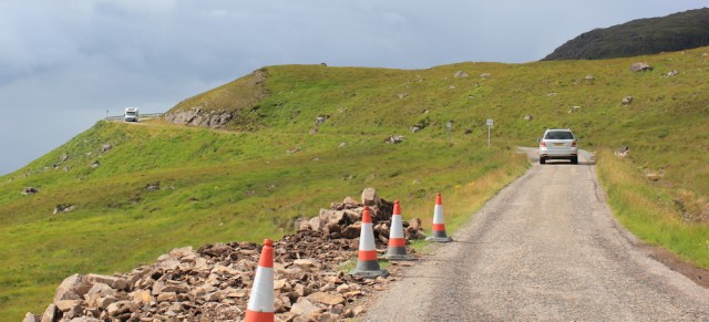
The road is narrow, with occasional passing places. I come across a line of cones, and a digger seems to be excavating part of the hillside, possibly to create another passing place.

I know the volume of traffic using the N500 has been a problem. The route has been well publicised, especially abroad, and attracts many foreign tourists. It’s almost too popular now. Good for the economy, maybe, but the infrastructure struggles to cope.
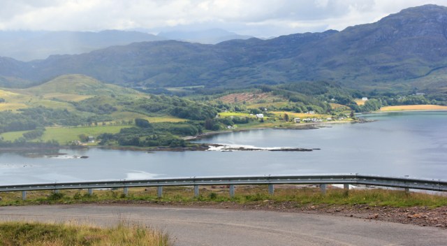
Higher still, and I get a beautiful view overlooking the mouth of the river and Loch Kishorn. Shame the light is still too dull for decent photography.

Onwards.
What a beautiful valley this is. There has been virtually no traffic so far – not since I left the turn-off to Kishorn Port behind. Now, here’s a camper van coming, slowly, towards me.

I stand aside to let the van go past. Soon come to a bridge over a pretty stream. Russel Burn, says my map. It’s fed by a loch further up the valley.
A few hundred yards beyond the bridge, the road turns sharply to the left. Here, a track carries straight on towards the hidden loch. I would like to go up this track and explore… but decide my planned walk is long enough without unnecessary diversions.

Instead, I perch on the grassy bank beside the track and have a snack and a drink. I know the toughest part of the walk is soon to come.
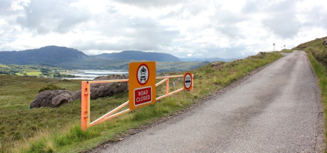
The next section of the road can be closed off when weather conditions are bad.
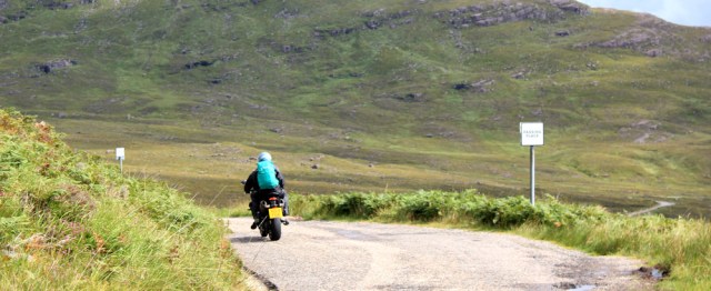
A motorbike zooms past me, and I snap a photo of his disappearing back.
It’s nearly 11:30 am, and I’m beginning to see more traffic now. Cars, vans, and mobile homes. I pass another set of cones, guarding what I think will become another passing place.
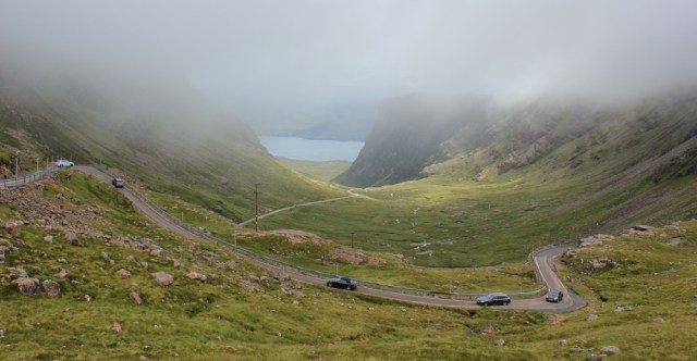
The road curves around the shoulder of the slope, and begins to head further inland, climbing more steeply up the pass. I turn round to admire the view over Loch Kishorn, knowing I will soon lose sight of the sea.
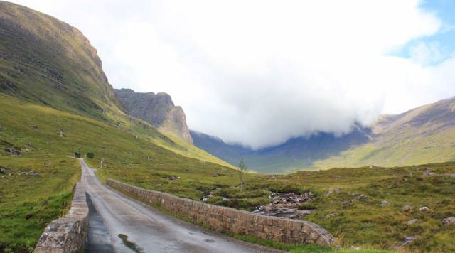
The road winds up the side of an impressive valley. A grassy meadow to my left, before the land drops down into the gully where a stream runs. To my right is a wall of stern cliffs, their tops covered in cloud.

A little minibus has stopped in one of the few passing places. At first I think they have broken down, but then I realise they are just admiring the view.

(This is the sort of touristy behaviour that must really irritate local people!)
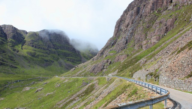
Past the minibus, and the valley narrows as the rocks crowd inwards and tower above me. In the gap ahead I can see sheets of mist being blown into the valley, where they quickly dissipate.
This moving, changing, nature of the mist gives me hope that it will lift before I reach the top.
I’m getting tired now. The climb is not unduly steep, but it has been relentless for the past 5 miles or so. There are few opportunities to rest, as the terrain is steeply sloping and the road is guarded by crash barriers.
When I see a handy outcrop of rocks ahead, I seize the chance to leave the road, and climb up the rocks to perch near their top. I’m very close to the road, but about 10 feet above it, with my legs almost dangling over the tarmac.
What a fantastic view. I can see all the way down the valley to Loch Kishorn.

Time for a drink and a snack, and also an opportunity to look at my map.
The river is called Allt a’ Chumhaing, and the valley is called Coire na Bà. Coire means cauldron on cooking pot in Scottish Gaelic. And, although the word bà sounds like it should mean sheep, it actually means cattle. So this valley’s name, translated, is the Cauldron of the Cattle.
Luckily, I don’t meet any cattle on my walk today.
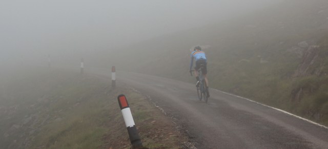
A cyclist comes charging down the hill. The road is a blind bend before my rock, and he suddenly sees me with my feet dangling a few feet above his head. Does a wobble, and nearly falls off his bike. Sorry!
Time to climb down and get on with the walk.
I reach the gap at the top of the valley, in anticipation that I had done the worst of the climb… but no! The road zigzags up the final climb in a series of hairpin bends.
The slope is too steep to scramble up easily, so I have to stick to the road, which is frighteningly narrow in places. An increasing number of cars and vans are making their way up or down the pass, and I must keep my ears tuned.
It’s not exactly a steady stream of traffic, as the vehicles get bunched up behind the slower drivers, and are further bunched when they have to pull aside into passing bays.
I huff and puff my way up, stopping for regular breathers, and photographing what I can see of the view between clouds of mist.

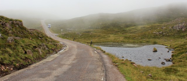
Finally, I’m at the top of the valley, and the road is flatter, although still climbing. The mist hasn’t cleared after all, and hangs low above my head. But the landscape opens out, filled with grass, rocks, and little ponds of murky water.
A minibus is parked in passing place. It seems to belong to an organised-tour company, and the driver is just sitting there, waiting. I wonder if there are a group of hikers out there, somewhere on the misty mountains, and if he is waiting to pick them up.
I haven’t seen any other walkers today. But most sensible hikers wouldn’t follow the road, would they?
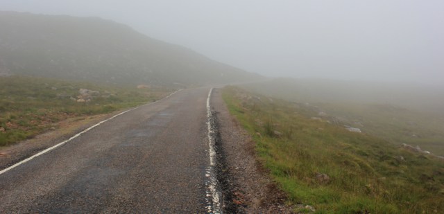
The road climbs a little higher, and the mist thickens around me.
Another cyclist glides by, with his feet resting almost motionless on the pedals. I guess this is his first downhill stretch after a steep climb up the pass from Applecross. He must be exhausted.
Cars and motorhomes loom ahead. With a shock, I realise I must have reached the car park and “view point” as marked on my map. I’ve made it up the infamous Bealach na Bà. I’ve reached the top!
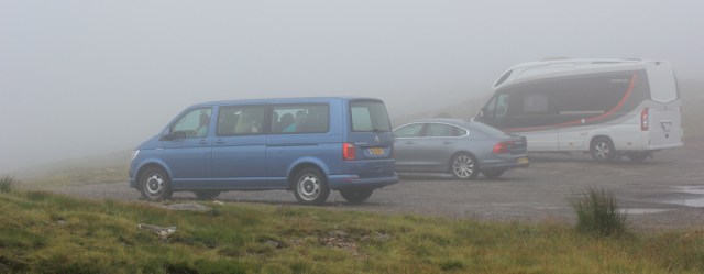
Most of the people parked here haven’t bothered to get out of their vehicles. What a shame about the view.
It’s 1:30 pm. Time for lunch. I leave the road and look for somewhere to sit. The grass is wet, and I struggle to find a flat spot among the rocks. I eat my snacks, surrounded by columns of balanced stones, as if being watched by a spooky, and hungry, audience.

The mist clears slightly, and I see more spooky figures nearby. Oh, real human beings! And there are seats over there too. If only I’d known.

After eating, I look at the metal plaque on top of a large stone – “Bealach Na Ba Viewpoint” – where handy guidelines point to far off landmarks.

Most places I haven’t heard of, but have wonderful names. Macleod’s Tables. Old Man of Storr. Some I have heard of Eigg 41 miles. Rhum 39 miles. Ardnamurchan 50 miles.
Only 50 miles to Ardnamurchan! I haven’t come very far, have I? Ardnamurchan was a beautiful peninsula. Shame I can’t see it.
[To be continued…]
More information about the Applecross bus: Lochcarron Garage bus times
This morning’s route:


Great write up Ruth and stunning photos. “Shame the light is still too dull for decent photography.”. Not sure I agree, you have the area part in sun and part in shade and I think it’s a lovely photo.
At the moment this route is my backup plan. I’m planning to park at the car park (marked on the map, anyway) by the pier at Toscaig (south of Applecross) and do a circular walk out on the paths marked on the map that go in a loop back to Toscaig. At the eastern end (Airigh-drishaig) I’m considering seeing if it’s possible to continue on the trackless land to get to the bend in the road above the salmon farm you found (where the height of 178 is marked on the map). I think Quintin Lake went this way but he did a lot more walking over trackless land than I have so I don’t know how feasible it will be (there are a couple of rivers to cross too). If not possible I’ll do that part as a circular walk and follow the road too, as you did).
Unfortunately I don’t think the bus will be an option for me now, though I did know of it’s existence. As far as I know public transport in Scotland is still not for the public to use unless making an “essential journey” (certainly the ScotRail website has a big pop up saying “Essential Journeys Only”). That said I might give the bus company a call and see if they will take me. There is no harm in asking, I guess. I’m a bit concerned that even if they are taking walkers again that if they are limiting the capacity (e.g. keeping many seats free) that by booking a seat I might prevent someone who lives in Applecross without a car from getting to the shops for their weekly shop. So I wonder if you’d mind if I ask – how busy was the bus?
Otherwise as I now have a folding bike, I’m thinking of driving to the top (the view point), then using the bike to cycle down to Applecross (hoping to mostly free-wheel!) and walk back. Then drive down to pick up the bike, drive back to the viewpoint and do the same in the eastern direction to Tornapass, but it does mean all the walking will be uphill (and I’ll have to drive the road twice). I think this will be easier than trying to cycle the whole lot one way as I suspect otherwise I’ll be walking the bike half the time.
Actually it seems that the distancing rules have dropped from 2m to 1m in Scotland too as of today and it seems Scotrail have got rid of “essential journeys only” so I’m hoping the same is now true of buses in Scotland.
Glad you’ve got a folding bike, Jon. It will make your trek much easier from a logistical point of view.
Your plan for walking uphill and cycling downhill was my initial plan too (my main worry with this plan was whether my old van could make it up the pass!). Then I discovered the bus, and it had only 2 other passengers on it from Applecross when I rode it.
However, walking around via Toscaig sounds a MUCH better idea. I briefly considered it, but chickened out, knowing that if I had turn back I would end up on the wrong side of the pass and separated from my van. Hopefully you will have the strength and experience to complete this successfully.
Thanks Ruth! That is very helpful. It sounds like the bus might be an option after all then. I’ll give the company a call if they don’t respond to my email in a few days. Would save doing the bit from Shieldaig to Applecross twice anyway.
Sadly the bus you used does not run any longer so I will have to discount that as an option. I had this reply from the company this morning.
“Hi Jon
Thank you for your enquiry, but unfortunately the council stopped the bus run totally when all the covid 19 started, and they have still not restarted it. We have no idea when the council will restart it again sorry”
Hi Jon, You can quite easily walk around the coast. There is a good path going from Toscaig to Uags Bothy. The stretch along Loch Kishorn has a path, but I only saw remnants of it You need to stay high and contour back towards the Bealach na Ba road. There is is no dangerous ground, just tough going underfoot. I did it in early September. Just aim for above the quarry, which is still used. I did actually slip on the very slippy rocks on the shoreline banging my knee. Definately doable by yourself. There are power lines running the length of the section, which I followed. The Lochcarron Garage Bus that took me to Tornapress had about 4 people onboard, all local. I also used the minibus in that October to take me from Applecross to Ardheslaig. On that occassion there was just me onboard with the driver, who was also a mechanic at the garage. Check out the Tr’s on Scottish Hills. Cheers . I’m off to Kent tomorrow for 2 days of walking and hoping to reach Sandwich. Cheers Alan
Your route sounds wonderful, Alan. Enjoy Kent.
Thanks Alan that is really useful, it sounds like my plan might work then. Hope you enjoy you walks in Kent. I enjoyed the section around Thanet, with all the white cliffs.
Wow
I also have stopped hiking for a while. I fractured my proximal humerus on the west highland way
Reading a map whilst walking
Careless of me
Oh no, Paul. So sorry to hear this. How frustrating for you, after months of lockdown, to be locked down in a different way. Hope you mend soon. Best wishes.
Sometime back in the eighties I did a massive tour of Scotland with my late wife using our caravan. Although I was game she wouldn’t let me take the caravan over there and we went the long way round. Applecross was heaven and I suppose much quieter in those days.
Applecross is still beautiful, but I’m sure it is much busier now, Conrad. Although sections of the pass were steep, my main concern would be negotiating oncoming traffic on a single track road, especially if forced to reverse around a tight corner!
Those columns of balanced stones look weird, they remind me of aliens from a far off planet 🙂 I’ve never heard of a ‘selfie box’ and find the idea rather odd but maybe it’s one of those ‘must do’ things for tourists to do to prove they’ve been there.
I don’t really understand the balancing stones craze. They are everywhere in touristy spots where there are enough flat pebbles around. At first I thought they were quite amusing. Now I just find them irritating.
You might have to bypass Lindisfarne. Folk have carried large amounts of stones off the beach and piled them up on nice grassed areas. We removed several piles back to the beach but made virtually no impression. You go to these places for their natural and historic beauty, why put a modern man-made mark on them? Whinge over.
Such a shame about the views! We had a glorious day in Applecross last summer. I graciously allowed John to do the driving (in other words, no way was I going to tackle it). While we were at that car park at the top we heard rumours of a bad accident behind us, and the road was then closed for the rest of the day so we had to take the long way round to get back to our apartment in Dornie. A motorcyclist had collided with another vehicle. We heard later he was ok, well some broken bones, but alive, thankfully. So it’s definitely a road to be wary of.
Glad you made it to the top safely, and how wonderful you had decent weather. One of the only plus sides of the COVID crisis is that it may reduce the number of foreign tourists visiting Scotland, and hence reduce the amount of traffic on the N500.
Pluses and minuses. Tourism is good for the economy, but we don’t want people potentially bringing in the virus from elsewhere when we have got it quite well under control – for the moment, anyway. It’s tough to know what’s best, but we’ll be sticking close to home this year.
Another beautiful if quite arduous walk and a treat to read your post. The view of Loch Kishorn are breathtaking in the early morning light but a shame about the views from the top. I suspect that mist is often the case up there.
Hi Karen. Yes, it was a shame about the mist. I’ll go back one day and see the view properly – but I might drive up next time 😄
Just curious to know how you got back to Lochcarron after abandoning the Beast on Tuesday (or is that to be revealed in Pt.2?)
Hi Ian, I left Lochcarron and drove the Beast round to a campsite in Applecross the night before. So, all I need to do is walk over the pass and down to Applecross. 😄
Sorry Ruth, I was being stupid. I misread your opening & thought your morning bus was from Lochcarron!! I remember a really nice B&B in Kishorn, but unfortunately we had to miss out on the Applecross “loop”.