
[This walk took place on the 8th August 2019]
I’ve reached Applecross and, following my rules, I should just turn northwards and follow the coastal road up to Sheildaig and Torridon. Instead, I decide to walk to the most southernmost point I can reach along footpaths, to the base of the Applecross peninsula, and work my way northwards from there.
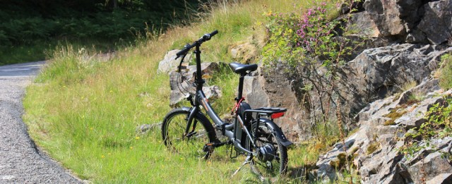
I leave my van in the campsite, and ride my Scooty down the road to Toscaig, and chain him up at the beginning of today’s walk.

To get to the start of the footpath, I must follow a narrow side-road to a place called Upper Toscaig, a mysterious place, that doesn’t even appear on my OS map. Toscaig, yes, and Toscaig Pier, but no Upper Toscaig.

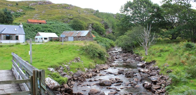
I set off walking down the road. There really is an Upper Toscaig – just a collection of houses nestling in a small valley. I can even see the beginning of the footpath – a green strip that passes behind the red-roofed building.

It doesn’t take me long to reach the red-roofed building, and I climb the green slope behind it, attracting the attention of a gaggle of geese.

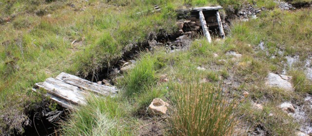
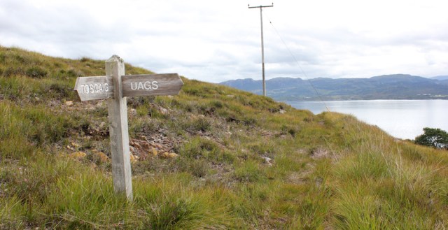
Luckily, I haven’t got very far when I stop to take some photographs across the valley. Look at that bridge down there, and the footpath sign… oh, no! Is that the way I’m supposed to go?

It’s not the first time I’ve headed up the WRONG path. Back down I go and check the finger post. Yes, THIS is the way to Airigh Drishaig. It’s only 4 miles.
I’m very relieved to see the footpath signs – a rare thing in this part of Scotland – not only because they set me off in the right direction, but because the signs imply a well-used and well-defined path must exist.
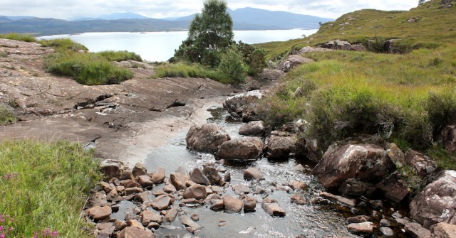
On the other side of the bridge, I stop to take a photograph of the pretty little river, the River Toscaig.
It’s a dull day, and I’m beginning to have doubts about the wisdom of today’s unnecessary expedition. I’m tired from yesterday’s slog over the Applecross Pass. But, I remind myself, I’m unlikely ever to come this way again. Having struggled so hard to get here, I might as well enjoy the area.
I follow the path over a meadow of long grass and bracken…

… and soon come to a fork. The left fork leads to Airigh Drishaig – still 4 miles away. The right fork leads to a place called Uags, which is only 2.5 miles away.

My plan today is to do a circular walk, heading across country to Airigh Drishaig, and then back along a coastal path the runs to Uags and back to this point. So far, so good.
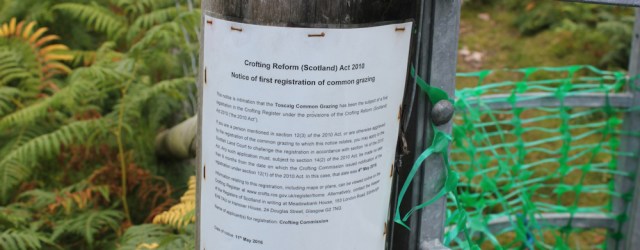
I take the left fork, and soon reach a gate. A notice pinned to the post gives “Notice of first registration of common grazing” and is dated May 2016. The deadline for objections has long passed, so I assume this hillside is now a common grazing area.
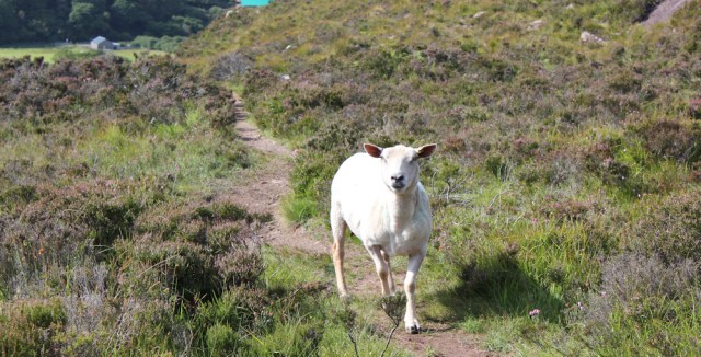
A sheep calls to me. She seems quite tame, but looks rather worried by my presence. When I pass through the gate, she follows me for quite a distance down the path, bleating loudly, as if trying to warn me of something.

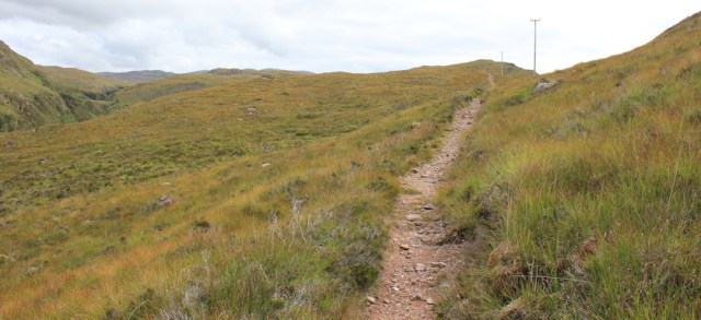
I’m climbing steadily uphill now, walking in a south-easterly direction, and into the brightness of the morning sky. This, and the poor light conditions, make photography difficult.
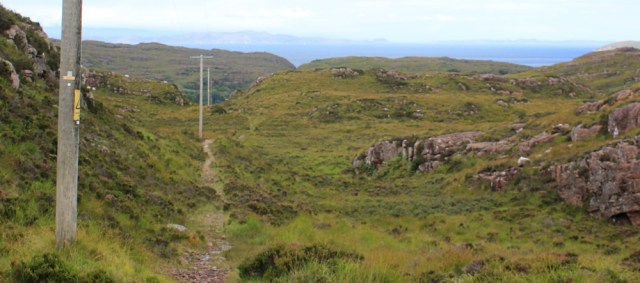
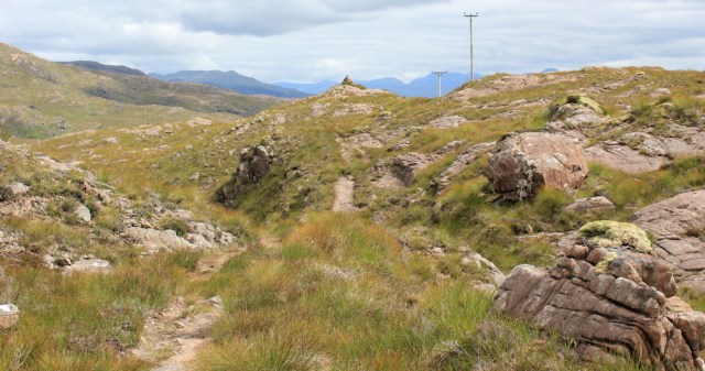
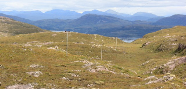
The path follows a line of poles, carrying – I think – electricity wires. But they might be telephone wires.

Over the crest of the hill, and the path continues downwards, still following the line of poles. There is sea ahead, south of here – good. Only another 3 miles and I should reach the coast.
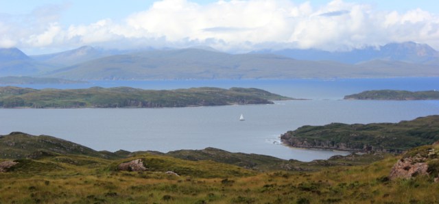
Further along, I get a better view. This time I’m looking to the west, and am somewhat confused by the amount of land I can see across the water, until I realise I’m looking at the Isle of Skye. What a beautiful view.
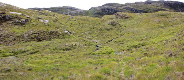
When planning this walk, the landscape was difficult to decipher on the map, with haphazard contour lines and no obvious way of deciding what was up and what was down.
Now that I’m actually walking across the terrain, it still remains difficult to decipher. It’s as if a giant has shrugged a quilt across an untidy bed – all lumps and bumps, without meaning or purpose. And it’s virtually treeless, with no clear waymarks to aim for.
Onwards, following the path, following the poles.

I head down into the confused landscape, and I’m glad the path is well-defined. For anyone unlucky enough to get caught in mist up here, the poles are a useful navigation aid, although, strangely, like the mysterious Upper Toscaig, their line is not marked on the OS map.
Now, to my left, I can see an obvious river valley. Check my map. It’s the River Toscaig.

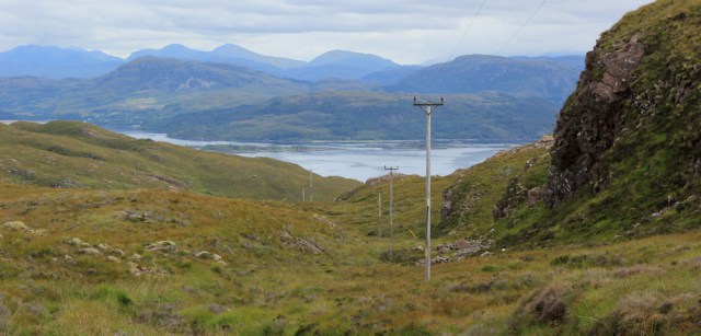
The path follows the slope above the river for a short while, and then the river makes a sharp turn and veers off to the north. My path goes straight on in a westerly direction, rising up a slope, still following the poles.
Down into another valley, and I come across a little stream, crossed by a footbridge. This is the Allt Lochan an t-Sagain. A long name for a narrow burn.
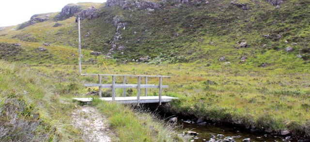
Over the bridge, the path continues to follow the bank of the stream along the valley, with the poles marching ahead to mark the way.

I climb a little rise… and here is a lake! Takes me by surprise, for some reason, but is properly marked on my map. Lochan an t Sugain. It must be the source of the little stream.
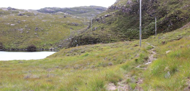
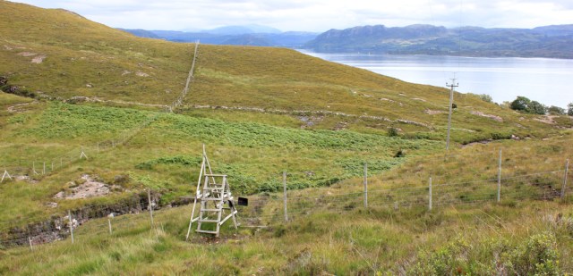
The path climbs over the southern edge of the Lochan, where I have to bend low to pass under the supporting cables of the electricity poles. They have been, helpfully, padded in bright yellow plastic.

As I reach the far end of the lake, the sun almost breaks through the clouds, and the light is just right for a lovely photo.

I stop in this beautiful place for a quick rest and a drink of water. I’m feeling terribly tired, and yet I’ve hardly come any distance at all yet.
Onwards. I leave the lake behind, and walk into the light of the southern sky.
There’s another little burn to cross – this one barely bigger than a dribble and with no name. The optimistic “FB” marked on my map (meaning footbridge) turns out to be a couple of rotting planks.
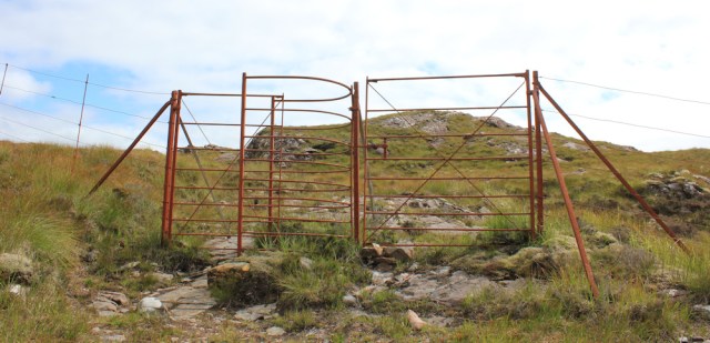
Beyond the “bridge”, the ground rises again, and I pass through a deer fence. The metal work of the gate is a rusty orange and, as usual, I’m not sure if the fence is designed to keep deer in, or to keep them out.
Over the next rise… and here’s another beautiful lake. Loch Airigh Alasdair.
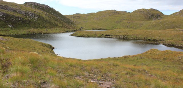
The path follows the poles along the northern edge of the loch, which turns out to be part of a group of little lakes.

Finally, I seem to approaching the top of the walk. There’s a cairn ahead, and a clear view of distant mountains.
I must say, it’s nice to be out of the scumbled landscape, and looking down a definite, if shallow, valley towards the sea. Look at the magnificent mountains on the other side of the water.
I perch my camera on a rock at the foot of the cairn, and take a self-portrait.

Onwards. I’m nearly there now. Downwards.
Unfortunately, the path disappears among the grass in the base of the valley, which turns out to be very boggy in places. Harder work than it looks. It’s a relief when the slope becomes steeper and rockier, and I find firmer ground to walk on.
I cross over another deer fence. No easy gate this time, just one of those steep ladder-type stiles.
A sign is nailed to the stile. “Welcome”. That’s nice. The rest is faded, but reads, “By agreement with the owner you are welcome to walk in these woodlands…”

This is a bit perplexing. As Scotland has a right-to-roam law, I’m allowed to walk here anyway. And, where are these woodlands? There is barely a tree in sight!
Just past the stile is another river, and this one is crossed by a rather fine, new-looking bridge.

I stop beside the river to take photos of the water rushing over the rocks.
As always, the view of moving water is always far more delightful than still photographs could ever be, and I fail to capture some of the prettier waterfalls. The light is bad, and I’m really tired.
A short time later, growing closer to the water, I reach another fork in the path. A sign tells me I’ve come from Toscaig, and off to the right is the path to Uags.
This must be Airigh Drishaig. Don’t know quite what I was expecting, but probably something more than just a signpost! Well, Uags is my next destination, but it is 1:30pm, and definitely time to stop for lunch.
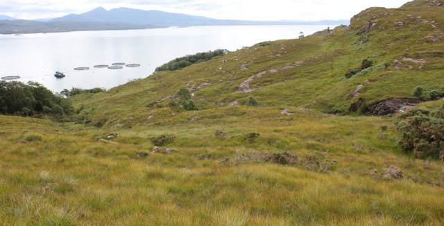
I find a piece of flattish rock and sit down. This is lovely. What a peaceful view. Below is a fish farm, and I can here the faint sound of voices coming from a boat beside one of the giant pens, otherwise the only other sound is the chittering of birds.

I spot a bridge on the far side of the water. Where is that? I take a photo on full zoom, and check my map…

It’s the bridge over to Skye, of course! I can even see the lighthouse underneath. I’ve walked a long way since I left Kyle of Lochalsh, and yet it still seems so near.
The sun comes out for a few minutes, and I feel it’s warmth seeping through my skin. Could stay here all day… no, come on, Ruth. Time to get moving. The longest part of the walk is still to come, as I plan to follow the path round the shore to Uags, and then back to Upper Toscaig,
I walk back to the signpost, and look along the route to Uags. But, where is the path? I stare down the slope of hummocky grass, and scan the uneven hillside across the valley. No sign of a path at all.
I can feel my heart sinking, and deep unease fills me. What if I can’t find a way round by the shore? What if I get half way along, and then am forced to backtrack? I’m so very, very tired.
It’s hard to admit defeat, and to wimp out of a planned walk. If there had been a clear path – or, in fact, a visible path of any sort – I might carried on. Instead, I decide to abandon the coastal route, and to just retrace my steps instead.
It’s only 4 miles back to Toscaig and, although it seemed much further on the walk out here, the return journey goes remarkably quickly. It helps that the sun comes out, and the light is behind me.

On the final descent into Upper Toscaig, I meet a solitary sheep on the path. She seems to welcome me, and I believe it was the same sheep who seemed so concerned about me on my outward journey. She looks relieved to see me again.
Upper Toscaig also looks welcoming in the sunshine, and much prettier than I remembered. What a difference the sun makes!

I cross over the bridge, walk past the house with the red-roof, head down the road, and find my Scooty bike waiting for me. Now all I have to do is cycle the 4 miles up the road and back to Applecross.
Well, it’s been a strange day. I’ve done an unnecessary walk through a very empty landscape, seen some beautiful views, and been watched out for by a very friendly sheep.
Shame I wimped out of the coastal section of the walk, but at least I’m in one piece and tomorrow is another day.
[Later, I look at the photos and discover my notion of the watchful sheep was a complete fallacy. It wasn’t the same sheep at all!]
Miles walked today = 9 miles
Miles cycled = 9 miles
Total miles walked around coast = 4,404 miles
Route:


I like the sunny view of Upper Toscaig, it looks really pretty – surprising what a difference a bit of sunshine makes to a view 🙂
Yes, everything looks better in the sun 😄
Hi Ruth, thats a shame you could not make it a circular route. The building at Airigh Drishaig is a single croft, sein the in the middle of gorse and occassionally ocupied. The “path” onto Uags, which is also a single building, but a well used bothy, is virtually none existant. I followed some intermittent footprints when I did this section, but the best policy is to set you compass on a certain bearing and make your own path on by contouring along on the easiestground. There is a good path after Uags, which is a great bothy, back to Toscaig.
Alan
I never saw the croft, and maybe it was a little further down the path. In retrospect, if I had walked to Uags first, I might have made it round by the coast OK, although as I was so tired that day I think I might have wimped out of the final stretch anyway!
You did not “wimp out”. You made a sensible decision based upon your energy levels and the land you found yourself in. But what a glorious walk, all that isolation :). (err, do you still carry the PLB?)
Ah, thank you Jayne. I think the walk over to Applecross had exhausted me more than I realised. And then there is riding the Scooty bike… an added exertion despite its electric assisted mechanism.
A job well done. That is the sort of walk that stays sharply in the memory bank.
You’re right, Conrad. It was a memorable walk. Such an empty landscape.
A lovely walk in beautiful surroundings. I don’t blame you for turning back, feeling so tired and being unsure of the path would have made carrying on quite stressful.
As always, such splendid photos – I think my favourite is Loch Airigh Alasdair, it looks so still and serene.
I wonder if there is an Alasdair who one owned the loch? If so, he was a lucky man.
Well done on even attempting an “unnecessary walk”! At the moment the weight of the thousands of miles ahead of me on my mind urges me to stick only to what my rules allow (although I did go to weird Roa Island ‘cos I like weird places).
I’m sure that sheep wasn’t hungry at all and expecting you to give it some nice food, it was clearly only attracted to you for your magnetic personality and charisma 😉
There are a few more “unnecessary walks“ to write up. I now see them as a major milestone for me – to be able to take my eyes off the main goal and just chill out in the moment – a skill that I’ve taken 60 years to acquire 😆
As for the sheep, I’m sure I have an animal magnet attached to me somewhere. I often pick up stray dogs on my walks, and seem to attract a lot of cattle too!
😂🤣😂
Hi Ruth – so nice to see a part of the coast that I did not walk. I ‘wimped out’ even more than you and just walked from Applecross down to Toscaig and back. If I had known there was a path I might not have walked over the Bealach and might have followed the coast all the way but on a map it looks incredibly tough and at the time I was carrying an 18kg pack which I found extremely difficult over such rough ground. Have just passed the first anniversary of completing my coastal walk. I feel so unfit and lazy now. Lockdown has born its toll. Can’t believe it’s a year since I got back to Rye. Carry on the good work – all the best Chris
Hi Chris, how lovely to hear from you. Lockdown has been hard, and I have lost most of my fitness too. Can’t believe it’s a year either. I’m just about to go back up to Scotland, staying in a s/c lodge because the Beast is awaiting repairs! Best wishes, Ruth
I’m going to be in Golspie for two weeks at the end of September and then on a landscape photography course based in Gairloch for a week towards the end of October. Can’t wait!
On holiday in the Lizard Cornwall as normal, not as daring as you! Mr Williamson (Dover)
Hope you enjoy your holiday Brian. It’s going to be a hot few days ☀️
Just went down to the cliff tops of the Lizard, stunning wild and planted plants abound with eachother, even the weeds are five times the size they are in towns, and are covered in blossom! The sun through the light fog looks incredible!!!!
Good luck!
I think you did the right thing here turning back. I did the full circular walk you were planning yesterday but the path from Airigh-Drishaig to Uags was really really hard with no path at all so it was all over very boggy and uneven terrain and took me a very long time! I wouldn’t have done it if I’d have known how tough it would be.
I also did make it from Uags to the bottom of the Applecross pass by making my way over the open ground (though I had to do it in two parts as it is otherwise to hard to get between Toscaig and the base of the Applecross pass given the distance and the fact the bus doesn’t run any more). So I got around without going over the Applecross pass.
The house at Airigh-Drishaig did appear to be occupied. There were even socks hanging out to dry on the fence! The bothy at Uags was also in use and quite busy also with some more people camping out the front. The path from Uags back to Toscaig was hard too but not as bad as earlier in the walk.
Stunning views and very beautiful throghout however. Not a lot has changed since your photos from last year!
Ooh, you were brave Jon. Glad you did it and well done for fighting your way along that non-existent path. I’m in the area too, and in Torridon at the moment! Last minute decision when I saw the forecast and found somewhere to stay on booking.com. Heading to Red Point today and planning to walk to Craig bothy and back. What wonderful weather we are having.
Enjoy the walk to the bothy from Red Point. It should be wonderful (but hot!) in warm weather. When I did it in the reverse direction the burns were in full spate and it was a real struggle with an 18kg pack on. You should just be able to really enjoy the stunning scenery to the south of Torridon – one of my favourite parts of Scotland. I walked it on my birthday and it was one of the toughest days of my entire walk. To cheer myself up I stayed in a very swanky hotel a little further north. Experienced the worst most aggressive cattle en route though so do take care, although at this time of year any cattle should be less aggressive.
Hi Chris, just finished this walk and wish I could say I enjoyed it, but it was a real struggle. Difficult path with loads of mud and unfriendly stones, so no chance to get into a rhythm of walking, and I had to watch every step. The worst moment was reaching the end at the bridge by the bothy, and not being able to stop for a rest because of the midges, before turning around and doing it all again in reverse. The views were wonderful – when I could raise my eyes from the path. I don’t know how you did it with a full pack and with loads of water everywhere! The cattle were all over the beginning of the path, with calves, but didn’t cause any trouble.
Sorry to hear you didn’t enjoy it Ruth. It perhaps doesn’t help that there has been quite a lot of rain around earlier this week in that part of Scotland which accounts for the mud. If it’s any consolation the part from Lower Diabaig to Craig is easier (and also shorter). Not easy, but certainly easier! And I know exactly what you mean with midges unfortunately. They are not too bothersome when you move but the second you stop they are everywhere. I think I got at most about 20 seconds before they are everywhere which makes finding somewhere for lunch tricky.
Chin up – bar the Postie Trail and the walk to Cape Wrath you are now past all the most difficult sections. I forgot about the midges! I was lucky and escaped the beasties almost everywhere. Torridon is renowned for the wretched things. Such a shame – I really thought you would be able to enjoy that section.
Opened the century/millennium staying at Uags. The walking around there is definitely testing. That lovely path is now on my hit list
It’s well worth it.
Pingback: 354. Toscaig to grid reference NG796386 | Round the Island
My wife, who is 69, and I, a septuagenarian, walked the complete circuit yesterday with our border terrier Sky. Starting from the holiday cottage, Cruinn Leum Round House, Toscaig, where we are staying we took the path over to Uags. What a glorious spot this bothy occupies, there was no one staying. Having noticed the coastal path marked on the map we headed off for Airigh-Drishaig. It soon became apparent that this path had long since failed to exist with only small sections being visible. Eventually after battling the rough terrain we reached our destination. Here is the last use of the remaining house I have been able to find https://www.earthskylearning.com/copy-of-family-wild-camp-1. From Airigh-Drishaig we made our way back to Toscaig following the interminable line of poles across the moorland back to our cottage. I have since found that in the walk descriptions for both the walks in Walkinghighlands web site does not recommend using the coastal path!
Hi Ken. Well done for completing the circuit! A beautiful area, but shame about the non-existent path.