
[This walk was completed on the 8th July 2022]
Different weather today. Still plenty of clouds, but they are lighter, don’t drop any rain, and there are patches of sunshine moving across the landscape. I cycle back to the layby where I ended my walk yesterday, leave my bike in a ditch, and set off.

Nearby, a track leads off into a different branch of this same valley. Two “core path” signs tell me I can go this way to get to Lochluichart 18 miles away (never heard of it) or Kinlochewe 15 miles away.

I stayed in Kinlochewe two years ago, in a little cabin in a midge-infested grove, when I walked from Torridon to Red Point. Is it really only 15 miles away? Always a shock to realise how far you can walk around the coast without really getting anywhere!
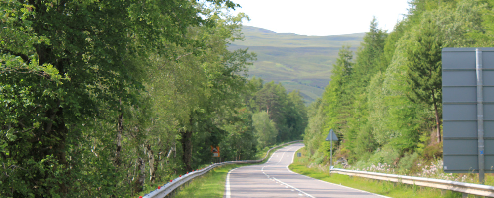
Anyway, onwards. The valley has bifurcated. The core paths lead southwest along one of the branches, but the road sweeps round in the opposite direction, heading northeast.

There are pine plantations in the valley, but much of the landscape is bare. Below me are the remains of more felled slopes. What a mess.
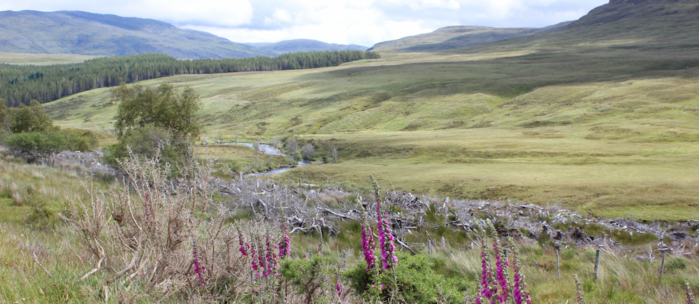
I thought I had already reached the bottom of the valley, but no – I’m still going downwards. Ahead the road crosses over a river, and below is the roof of a little building, which turns out to be part of a hydroelectric scheme.
Scotland has loads of these hydroeclectric plants. Some are massive, and some are tiny and can only supply a couple of communities with power. I suspect this is a large one, but there is a workman’s van parked on the driveway, so I don’t go down to investigate further.
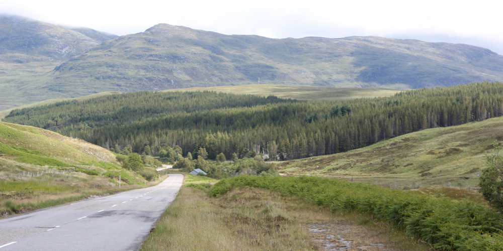
Walking without a map always makes me nervous, but all I have to do is follow the road, which now flattens out. Still going downhill. I pick up speed.

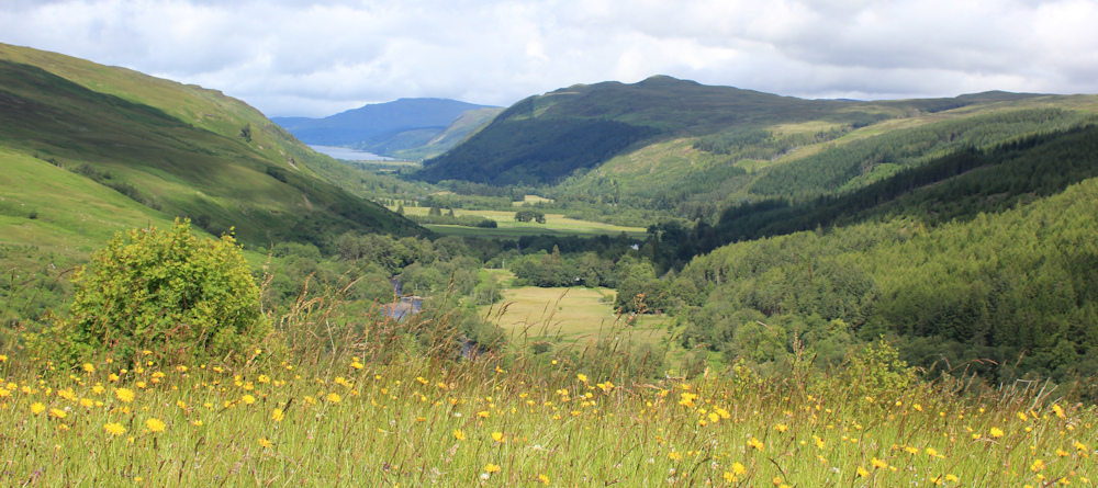
I walk past waterfalls, over another roaring river, past a sign that says this is the Cuileig intake, and then reach a place where a vista into another valley opens up. Beautiful.

Ahead is a car park (which I later discover is labelled as a “view point” on the OS map).
I stop at the edge of the car park and take photographs of the valley below. Is that Loch Broom ahead? it must be. Looks so close.
In fact, it’s tempting to try and find a short-cut by going straight down the hill but, even though I don’t have a map, I know there is a river in the way and… I don’t have a map!
Onwards, along the road.
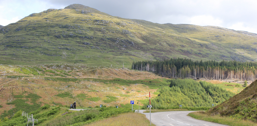
After a steep climb uphill, I come to another car park. This one has no view but is for visitors to the Corrieshalloch Gorge. It is full. So, I decide the gorge must be worth seeing.

The signboard explains there are two walks you can do. One is short, the other longer. It is possible the longer one could provide a shortcut down into the valley, but I decide it’s unlikely I’ll be able to get out of the gorge – it will be a circular walk, I bet.

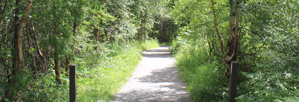
So I take the shorter walk instead. It’s good to be walking through trees.
Descending into the gorge, I reach the suspension bridge, which is the highlight of this walk. Only 6 people at a time are allowed on the bridge, so I have to wait my turn.
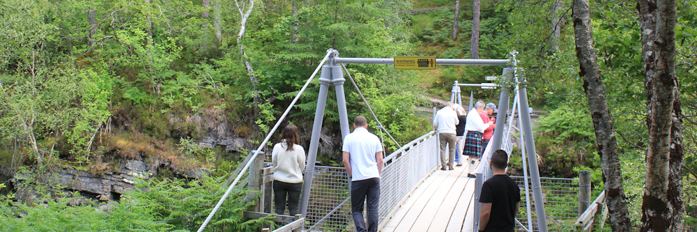
After days of walking on my own, it is frustrating to have to wait for other people! I mutter and fidget, until there is space for me.
The wait is worth it. The view from the bridge is spectacular. I take a great many photographs, but few capture the real character of the place – its depth and shade, the colours of the rocks, and the rush of foaming water.

Returning to the top (a little out of breath from the climb out of the gorge), I continue along the road. The junction with the Ullapool road must be just ahead…
Ah, what is this? They are building the “Corrieshalloch Gateway Centre” and it is “coming soon”. I suppose this is probably good news… it might mean a cafe and some decent toilets!

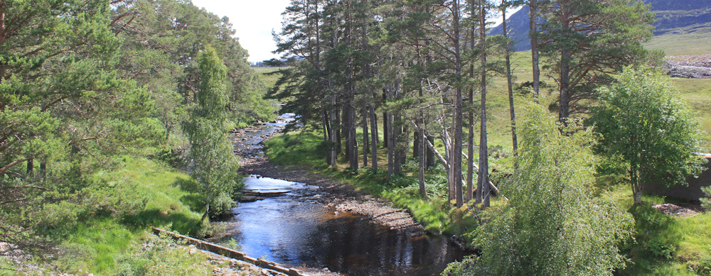
Past the building site, a sign tells me I’ve nearly reached the Braemore Junction. But, first, the road swings around a corner and crosses a wide, shallow river. [The Abhainn Droma, I find out later.] This river must, I guess, feed down into Loch Broom.
The river is lovely and tranqul, with tall pines along the edge. A nice contrast to the building site behind me and the bare, open slopes beyond.
Just over the bridge is the junction I’ve been walking towards. The Braemore Junction. And now I’m going to follow the road into Ullapool. But first, I stop for a cup of tea in my van (parked across the road in a parking area)…

… and then I have to drive back to pick up my Scooty bike.
Something weird happens while I’m collecting the bike. I’m just wheeling Scooty back towards the van, when a car comes up behind me and pulls off the road into the layby. But… the driver misjudges the layby, and pulls off too early.
I hear the crunch of tires over stones, and an ominous scraping sound. Then the engine roars, the wheels spin, and… the car doesn’t move. It’s beached on a couple of large rocks.
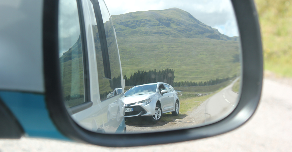
Of course, I go over to help the driver, who seems in a mild state of shock. At first he is pleased to see me, but is disappointed to discover that his rescuer is a lone woman. There is another car in the layby, but the driver is asleep in the reclined front seat with a towel over his face.
We try to push the car backwards off the rocks, but it doesn’t move an inch. It’s a hire car, and the man is not familiar with it. He starts the engine again. The wheels spin. Gravel and mud fly everywhere. I only just manage to dodge a face-full of grit.
But the car refuses to move.
I remember the time I drove my car into a ditch on the Mull of Kintyre, and so I suggest we call the AA or another recovery service. But the driver seems reluctant to seek outside help. I go back to the van to fetch my phone, and hear a roaring and a grating – he’s having another go – and, much to both our surprise, he finally manages to drive forwards and over the rocks.
The car is finally free.
“I’ll watch you drive off,” I tell him, remembering what the rescue-truck driver said to me on the Mull of Kintyre, “and let’s just check your tyres are OK and you’re not leaking petrol or oil.” He pulls onto the road and drives slowly for a 100 yards. I give him the thumbs up sign, and he drives off with more confidence.
Well, that was weird. It’s the second time in a few days that I’ve come to the rescue of someone – although in this case I didn’t do anything much apart from offer moral support.
Time to start the second part of today’s walk. It’s only a short section, but will take me within striking distance of Ullapool. I drive to a convenient parking spot, cycle back to the Braemore Junction, and set off along the A835.
I wasn’t looking forward to this section – a trudge along the edge of a busy A road – but my mood becomes buoyant and everything suddenly seems bright and wonderful. The sun is shining, I’m on my way to Ullapool, and all is good with the world.
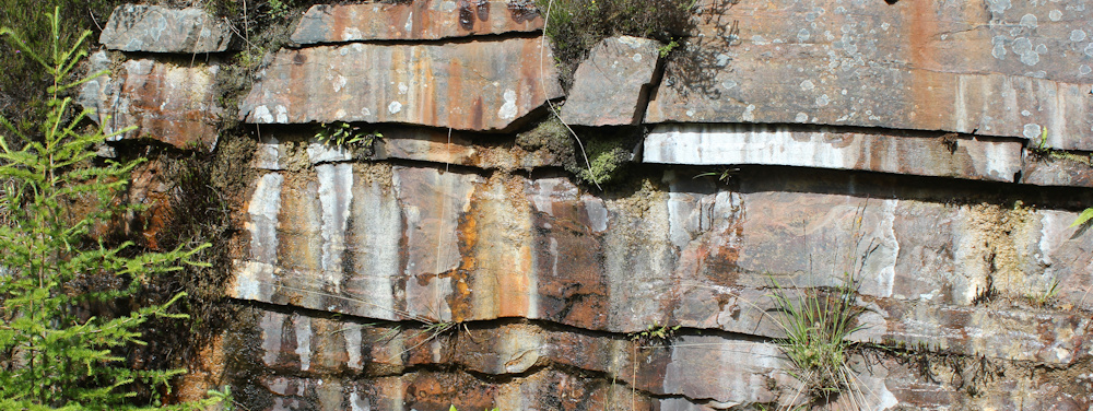
Look at the colours of those amazing rock formation. Layers of geological history. And artistic too.
I walk past waterfalls and take a shortcut through a parking layby, past a brilliant patch of yellow flowers.

The traffic is surprisingly light. Yes, there are caravans and motorhomes, and the odd bevy of motorbikes, but the verge is firm and the grass short. Easy walking.

These are holiday rentals, in what was probably once the stable block of a grand old house.

This is Braemore, and nearby is a sign for “Braemore Walled Garden”. Tempting, but I’ve already had several diversions today. Onwards.
The trees here are majestic. There are some newly planted areas, but most of the woodland is well established and with an exotic mix of trees – no mono-culture plantations here. Look at these towering specimens.. with red trunks… they must be giant redwoods!

I’m approaching the end of my walk – a car park in Lael Forest Garden. It’s almost a shame to stop.

Tonight I’m moving from my current B&B to a new B&B on the outskirts of Ullapool. Well, not a B&B exactly, because this one doesn’t do breakfast either! So, just a B. I’ve spent six nights in Aultbea and I’m looking forward to a new base… tomorrow I’ll finally walk into Ullapool. Can’t wait.
Miles walked today = 6.5 miles
Total around coast = 4,779 miles
Route:


Great progress Ruth and lovely views. Looking forward to Ullapool!
Ullapool was a real treat
Goodness, we arrived in Ullapool on 11th July! Could we have overlapped? We visited both Corrieshalloch and Lael while we were there.
Oh wow! Nearly. I was just north of Ullapool by then. Would we recognise one another? x
I would certainly recognise you!
Beautiful gorge. I’m not sure I have ever crossed a bridge with a restriction on numbers. Presumably everyone panics if a seventh person steps on? 🙂
Ha ha. While I was on the bridge, a family arrived and just marched straight on, bringing the number to about 12. I did some mental arithemetic and decided as we were all a reasonable size it must be OK 😀
The fact that you are posting this means you survived the road walk to Ullapool! I’ve done it once and won’t do it ever again.
It wasn’t too bad Roger. The bad weather helped!
Looking forward to north of Ullapool. That scenery has a character of its own with dramatically shaped hills.
Yes, indeed. I was thinking of you when I did some of the later walks, Conrad.
I was surprised to read in your account – “even though I don’t have a map”
I can’t imagine you have got so far around the Isle without a map, so I’m assuming it was just that day in question.
It is difficult and expensive to keep up with all the paper maps you need, but even I have now the OS maps on my phone.
A good read as usual. Keep going.
You’re right. It was just this day. I usually carry paper maps, but I didn’t realise i had to go quite so far inland to cross over to the Ullapool road. So, I didn’t have that particular map with me. I do have a garmin with a map display. It’s useful for showing me where I am and things in the immediate vicinity – but I don’t find it useful for planning walks.
It might be an idea to leave a promnent note attached to your bike (tied to the handlebars?) saying the bike is not abandoned and you’ll pick it up later in the day. Otherwise someone who is basically not dishonest might choose to believe it is abandoned and to “tidy up the countryside”…
Good idea, Tony. I used to leave trainers with my bike and a note, but now I don’t bother. Should probably restart the habit. I do have an enormous D lock – my main fear is that someone just picks the bike up and loads it into a van.
The sight of thise wild flowers in one of the later photos! I’d already forgotten that we had quite a good summer this year, or actually, that we ever have summers!
The flowers were lovely in Scotland this year.
It is annoying having to shell out for a map that you’re probably never going to use again just to cover a few miles. But here are plenty of sites (like streetmap.co.uk) with free OS maps on them (they might not be fully up to date but that rarely matters). In such cases before I set off I get on-screen the little bits I’m missing and literally take a few photos of my computer screen so I’ve got those bits on my phone as images without needing a map subscription or a phone signal. You do need a well charged up phone though. Mind you if you’re actually going trekking over boggy ground in the middle of nowhere and would be completely stymied if you then dropped your phone into said bog, maybe caution is the better part of valour after all!
I can certainly recommend the phone app ‘OSM Viewer’. This accesses Open Street Mapping, which while still not on a par with OS, is free and often shows newer footpaths that aren’t on OS. The app is free to download from the Playstore, and use is free. Once you have looked at an area (e.g. on wifi), it is saved (on a 120GB SD card if you fit one and wish it), and thus can be accessed without using your data allowance or needing a phone connection.
The only thing to watch is that you’ve looked at (on wifi) on all the zoom levels you are likely to need, as it only automatically saves what you’ve actually seen.
Much better than Viewranger that I used to use (before it became pay-only).
It also locates you on the map, making navigation almost too easy.
Here’s Ullapool, for example: https://www.openstreetmap.org/#map=16/57.9004/-5.1596
I’ll second that. I use Komoot but it uses the OpenStreetMap database. There are a lot of paths on OSM that don’t appear on OS maps too.
It did try to take me through Heysham Nuclear Power station though 😕
I love my paper maps, just didn’t have this particular one because I midjudged the route. A little known tip – but Bing Maps displays the OS map for free. https://www.bing.com/maps/
Bing doesn’t helpfully tell you where you are on the map, though! I should have added that OSM Viewer (which does) seems to use hardly any of the battery’s charge.
Just looked at OSM mapping around Ullapool, and it wouldn’t have helped you in Lael Forest. OSM depends upon uploads of GPS tracks by users, and the serious ones are probably a bit thin on the ground there. It would at least have told you where you were in relation to the Forest edge and road, though.
Gorgeous location. We have walked there numerous times.
It is a lovely area. Stunning scenery – even in the rain!
Beautiful views and Corrieshalloch Gorge is amazing. I wouldn’t like that bridge though especially if extra people got on!
One of those places I would like to revisit and explore again.