
[This walk was completed on the 14th July 2022]
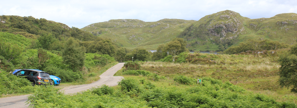
This morning, I first drive and then cycle along a terribly beautiful but treacherous road – full of steep hills, blind bends, unexpected twists and turns. Finally, I arrive back at yesterday’s unofficial parking place. Throw my Scooty bike in the ditch, adjust my high-vis vest, and sling my rucksack over my shoulders.

All thoughts of doing the Postie Path are gone. Last night, I drove to my new B&B in Lochinver along the main road, and it took me ages to get there – far longer than I anticipated. (If you look at a map, you’ll see why!) So now I’m filled with a minor panic about my pathetic walking mileage, the distance left to go, and the fact that another year is passing and I don’t seem to be getting anywhere.
Anyway, here I am, back on the banks of Loch Bad a Ghaill. Still a dull sky, but the clouds are higher than yesterday and the views are much better. It’s a chance to take some decent photographs.

Up the road, and I soon reach the turn-off for Lochinver. Yesterday, I was toying with the idea of walking along to Achiltibuie – all the signs seem to promote the place. And, I haven’t had a decent view of the Summer Isles yet. But this morning I was filled with my will-I-ever-make-any-progress panic, and decided to simply follow the road straight to Lochinver instead.

This place is called Badnagyle on my map. That might mean “place/copse of the non-gael” or “the windy/marshy copse”. (Gaelic names are very literal, but their spelling can be erratic!) Anyway, it’s both windy and marshy here, and the place consists of the T junction, a road sign, and a single house.

“Unsuitable for coaches & caravans” warns the sign. Good job I’m on foot, then. Up the hill I go. As I climb, the views get even better. Can’t resist stopping to take more photographs.
By now, the road has almost doubled back on my former route, and I’m looking down on the copse called Clach Mor – where my bike is hidden in the ditch. Below the copse is the loch, and the great hulking mountains beyond.

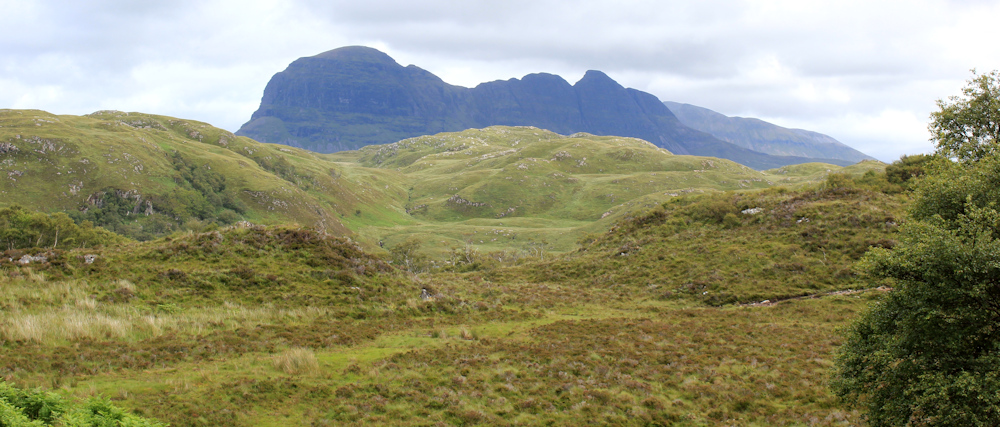
I check my map. Confusingly, all the mountain ranges around seem to have the same name – “Coigach”. But, I think those twin peaks are actually called Sgorr Tuath and Sgorr Deas, together forming Beinn an Eoin. To the right – with tops hidden in clouds – are the series of peaks that make up “The Rock”. On the other side of The Rock is the Postie’s Path.
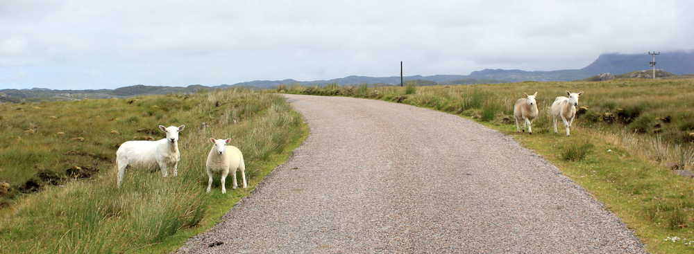
Onwards. Up this road. Nearly at the top – and only sheep for company.
When I reach the top, one of those miraculous things happens. The landscape falls away in a glorious view down the hillside to the valley below. There’s the sea in the distance – the sea! And little white homestead down there which must be… check my map again… either a fish farm or Inverpolly Lodge.
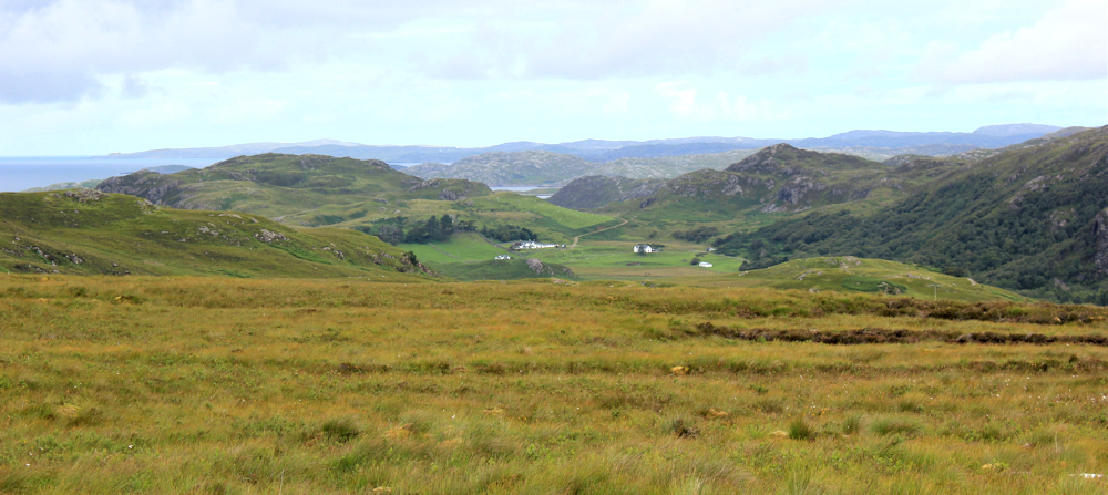
The buildings look deceptively close, but the descent takes some time. The road winds gently down, with rocky outcrops on one side, and green meadows on the other. I’m overtaken by a silver campervan (reminds me of The Beast), but otherwise the only company is a few scattered sheep.

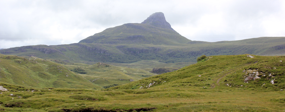
Look at that mountain! It can’t be Mount Doom / Stac Pollaidh again – or is it? The views are confusing – because you can see such a long way across the valleys and the twisting of the road makes you lose your alignment. I have to resist getting my map out to check. I’ll never get anywhere at this rate! Anyway, it’s an impressive peak.
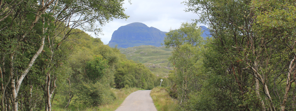
Takes me half an hour to descend to the valley. Now I’m walking through woodland beside the River Polly (a very un-gaelic sounding name.)
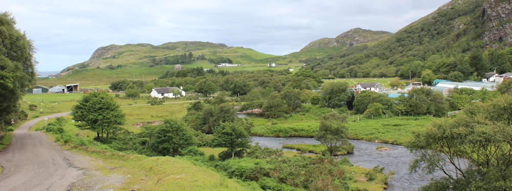
The river is crossed by two bridges. The older one is for pedestrians only. The newer, and quite ugly, modern one is to take the traffic.
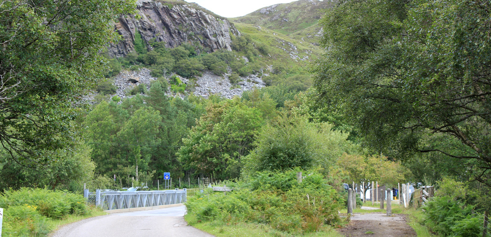
On the modern bridge is a battered sign, its lettering only vaguely visible through the rust. “This project is assisted by the European Regional Development Fund.”

On the other side of the bridge is the entrance to the fish farm. It is surrounded by high fences, with signs warning visitors to respect “biosecurity” and not to enter without prior approval. In such a rural setting, the stern notices take me by surprise. Slightly intimidating.
Beyond the fish farm, the road bifurcates. The main public road swings round to the right, while the branch to the left goes to Inverpolly Lodge.

Inverpolly Lodge was the white-painted homestead I could see from the top of the hill – although I have no idea if it really is a private house, or part of the fishfarm, or something else entirely. According to the map, it looks as though a track, and then a path, continues from the Lodge and links up, eventually, with my road further along.
It would be a good route, taking me closer to the sea. But the high fences and warning signs have raised my anxiety levels a little. I decide to stick to the road.
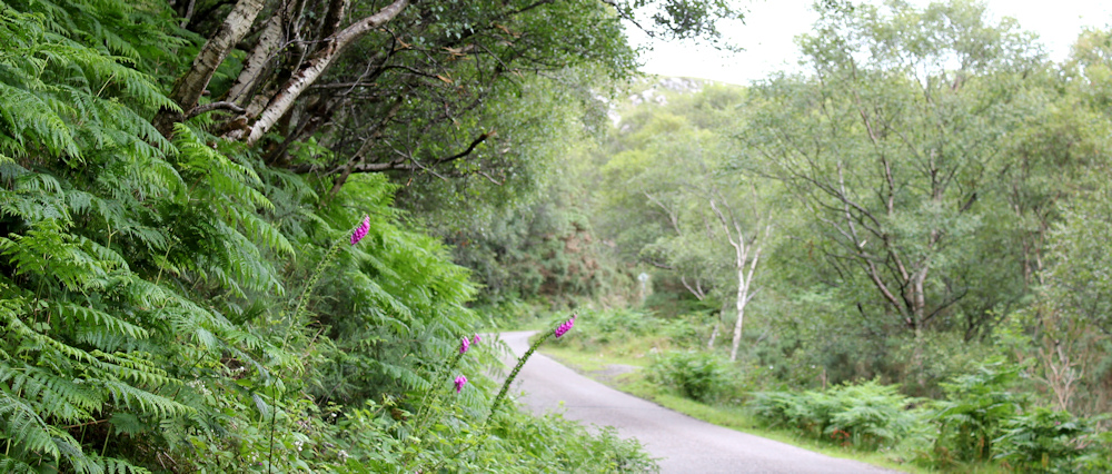
This begins to wind up the side of another valley, running through a wooded area. It’s very pleasant to be walking among trees. Look at that old shed half-hidden among the trees – and made from bits of corrugated metal sheets, cobbled together. I wonder what it is used for? Very mysterious.

The road is lovely, although a little worrying to find the verges are so narrow. There has been little traffic so far, but I’m nervous about drivers speeding around blind bends. Love the foxgloves. Create punctuation marks of colour among the green ferns.
As the road rises, the trees come to an end, and the landscape opens out again. To my right is a little loch, Loch na Dail, and beyond is that impressive peak.
The road twists and turns, still climbing, through another patch of woodland. I hear the revving of engines behind me, and stand safely to the side. Three sporty looking cars zoom past – and come to a shuddering halt at the next corner, where a red car has to swing into a passing place to let them come through.

A traffic jam! Very unusual.
Onwards. I’ve reached the top of the climb, and the landscape opens out again. I feel I’m quite high up, but it’s hard to tell, as the road is surrounded by slightly higher ridges and outcrops.

It’s nearly 1pm, and I’m hungry and thirsty after the climb. There is nowhere to sit – there never is when you need a seat – the grass on either side of the road is boggy and damp from yesterday’s rain. But then I spot this rock. It’s hardly scenic, but at least I can keep my bum dry while I sit and eat my lunch.
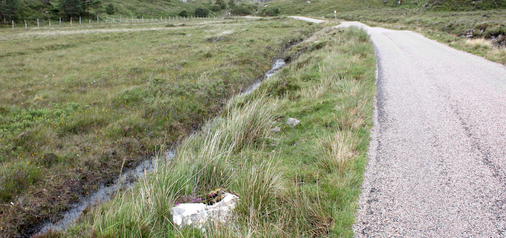
That’s the rock – right at the bottom of the photo above. Not very comfortable either. I quickly eat the sandwich I’ve made, and get moving again.
I always used to send my husband a photo of my “lunchtime view.” When I remember this, it makes me feel a little mournful. No decent view here, but I can take a quick selfie. Turn the camera towards my face and snap.
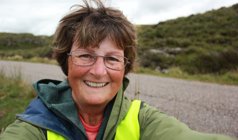
I’m getting better at this. Perfect first time!
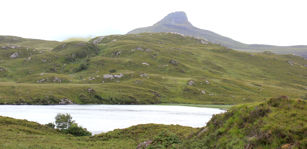
The road continues. There is a lovely little loch to my right, with no name on my map. Beyond is that peak.
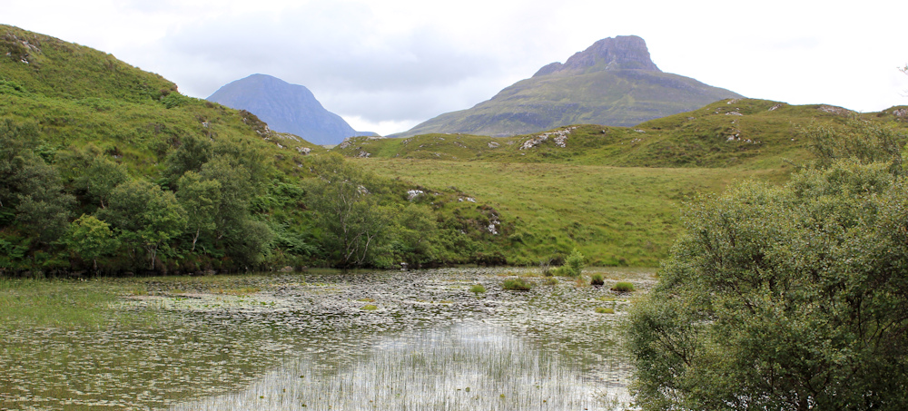
A little further on, and here is another pretty loch on my left. Nameless again. The scenery is less grand here, but still lovely. Reeds and water lillies dot the surface of the water.

The water lilies don’t show up well on the photos, so I leave the road to find a place near the water’s edge. Lean over. Snap some of the flowers – pale and delicate against the green plates of their leaves.

Mustn’t fall in! Onwards. The road curves around the top of this loch, climbing slightly higher, and heading to a pass beween two rocky outcrops.
There is something really primeval about this landscape. So bare, so open, so lacking in any manmade feature (apart from the road, of course!)
Over the top of the little pass, and what a wonderful view. I’m walking down through woodland now, and another impressive lump of a mountain looms ahead.
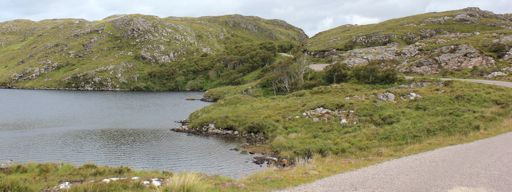
Coming out from the trees, and another fabulous view off to my right. The top end of Loch Call nan Uidhean is in front of me. The distant loch must be – pull out the map – Boat Bay. Interesting mix of Gaelic and English names.

I’m approaching a car-parking spot. It’s occupied by two cars – and I was hoping to park here earlier, but there wasn’t room. No sign of the occupants – they must be out hiking somewhere in these mountains.
Look at that view. Wonderful.
A sign nearby catches my eye. It is one of those usual “NO FIRES” notices, but this one is a little different – it has a lovely image of a deer surrounded by a flame. A great design. Like a woodcut. Almost monochrome and deceptively simple-looking, but visually stunning. Sends a clear message too.

Whoever designed that image did a grand job.
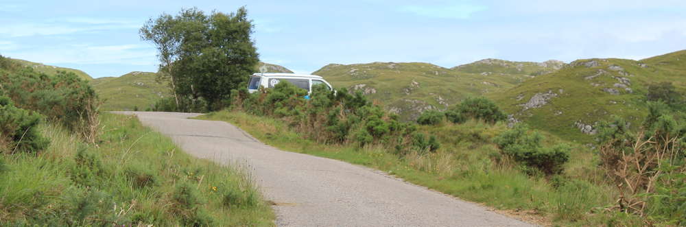
Onwards, along the road. Where is my van parked? Maybe around the next bend… look at that view.

Ah, there it is. All by itself and right at the top of the hill.
I was planning to walk a little further today, but the drive here was daunting, and the logistics of collecting my bike, driving back to find another parking spot (there aren’t many along this road) seem overwhelming. I’ve had a great walk – albeit a short one – and will have an even better one tomorrow.
Time for another self-portrait, perching the camera on the bonnet of the van and using the timer.

I found some information about the meaning of Gaelic place names on this document, hidden in the depths of the Scottish goverment’s web site. PlacenamesA-B.pdf
And I later discovered that the name Coigach, plastered across so many mountains on my map, is actually the name of the region. https://wikishire.co.uk/wiki/Coigach
Miles walked today = a miserly 4.5 miles (oh dear!)
Total around coast = 4,818 miles
Route:


Sometimes I hop onto Google’s Streetview and follow your walk. This was a lovely walk and believe it or not, I found your stone seat beside the road. It now is famous!
Ha ha. How amazing you found the stone seat!
Ah, I am jealous of your lovely selfies!!
Pure luck. With an iPhone you can see the image you’re trying to take. With my proper camera there is no image to see, so just pot luck 😀
Well, I only use an iPhone and yours are better so you must be doing something right!
This was always going to be the most arduous and logistically demanding part f the walk, but so worthwhile in terms of scenery and self satisfaction in the achievement, so just soak it up and enjoy step by step. You will eventually get back to romping away on longer distances. What you have achieved to date is awesome.
Thank you for your reassuring words Conrad.
The fish farm is not really intimidating – only the signs. I walked this section in a heatwave and I was desperate for more drinking water. So I called into the fishfarm. The staff were very welcoming and let me use their drinking fountain in the office to fill up my water bottles. Later I camped beside the loch at the top of the hill where you took your selfie. I love the scenery around Assynt and I love your description – primeval. It is so true. Keep up the good work!!!
What a lovely place to camp, Chris. It is such a beautiful area.
Hi Ruth – Of course it’s not for me advise you on your journey but the thought that “It is better to travel well than arrive” often helps me when the going has got very tough, and like Conrad says you’re already at Awesome!! I look forward to hearing more from you in 2023 so have a great new year travel well – Cheers Russ
Thank you Russ. And you’re right. I must stop fussing about my pathetic mileage and just concentrate on being present in the landscape.
I’m told that that road from to Badnagyle to Lochinver is known to locals as the ‘Wee Mad Road’, which I absolutely love as an unofficial name.
There is indeed a route via Inverpolly Lodge but it involves crossing a small dam at the Inverpolly end and stepping stones at the far end. My terrible sense of balance and a river in spate made it a challenge I didn’t care for on the day, so I backtracked to the wee Mad Road and continued along (thus taking the same route as you but with extra unnecessary steps).
The River Polly’s ungaelic-sounding name is because it’s been anglicised from Abhainn Phollaidh, meaning ‘river of pools’, which in turn is gaelicised from Norse Pollå (same meaning). I find the etymology of toponomy so interesting!
I don’t think you should worry about what speed you manage on these walks, or what mileage, unless you enjoy setting yourself newly challenging limits. You have more rules than I about coastal walks – I have only one: ‘it’s meant to be fun’ (although some days definitely push the envelope when it comes to defining ‘fun’). Anyway, the point I’m vaguely gesturing towards here, is that the best metric for how you are doing is basically ‘are you enjoying it?’ After all, isn’t that mainly the point? If you are, what does it matter if you do x miles and it takes y hours? I , for one, won’t be judging you on it…
Interesting to hear the origin of the River Polly’s name. If you look at the map, the “River of Pools” really does sum it up. After seeing your comment, I’m glad I didn’t take the Inverpolly Lodge route – the river would definitely be running high after all the rain, and I would almost certainly have fallen in!
I did follow that path, but the main difficulty I had was locating the start of it (I was going in the opposite direction) and crossing the river at Polly More. The path on from there to the damn wasn’t that visible or easy either. The damn and stepping stones weren’t actually too bad.
Oh, good for you. I think I spotted the end of the path (in a later blog) but the river looked really full and the stepping stones looked incredibly dangerous!
You are doing amazingly well, you have covered thousands of miles. Don’t forget the time lost to the pandemic. Even if you did have to stop now, it’s a massive achievement.
I love that photo of the dark mountains above the green (the one directly above the woodcut notice).
Hi Karen. Yes, the pandemic really slowed me down. And I lost fitness too. Funny how I often forget that those years actually happened! Like a time warp.