
[This walk was completed on the 26th April 2023]
My first Scottish walk of the year, and I am feeling wildly exhilerated to be back. I cycle down to the exact same spot where I finished my walk last year, hide my Scooty bike among some gorse bushes, and set off up the road.

I am a little disconcerted when a small van pulls up in the same place I’ve just left. Perhaps they will steal my bike? It’s locked with a massive, heavy D ring – but all you have to do is pick it up and throw it in your van…
While I hover anxiously, a woman and two small children get out. Relief. She isn’t going to nick my bike. They are watching me, also somewhat anxiously, because I realise they’ve stopped for a toilet break!
Onward. Along the road. What a fabulous view. The loch below me is Loch Duartmore (or Loch Dubhaird Mor – everywhere in Scotland seems to have two names). The distant headland is off my map… but I think it must be the Point of Stoer, aka Stoer Head. Seems a long time since I was last there.
I wasn’t looking forward to road walking, but it has turned out to be a remarkably pleasant stroll, so far, with very little traffic.

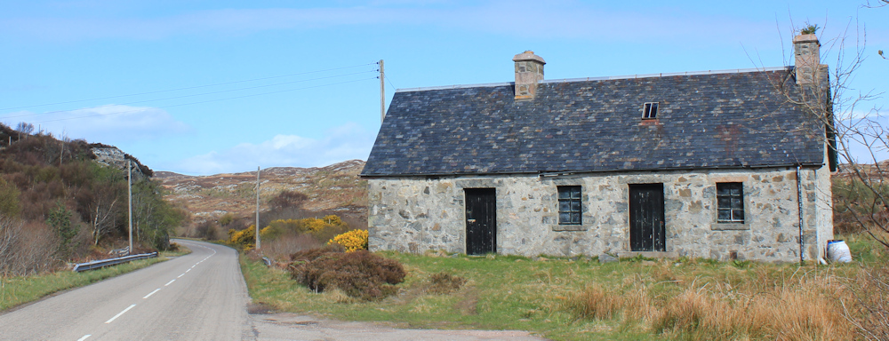
With nothing much to look at, apart from the scenery, I make good progress. Look at this sweet little abandoned cottage, in the middle of nowhere.
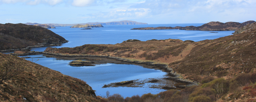
Nearby, and inland off the road, is a loch – Loch na Doire Dubhe. It seems much larger than the map suggests.

I remember I meant to turn off down a track before I reached this point, and walk closer to the coast. Either there wasn’t a track or, in my excitement to get walking I simply marched right past it. Anyway, too late now, and this road is rather nice, with enough twists and turns and dips to be interesting.

Here is the side road I might have joined if I’d found the track. A nearby sign says “Badcall Bay. No unaurthorised access.” Its another Scottish salmon farm. Good job I didn’t find the track – I might have had to turn back. But, just look at that view!

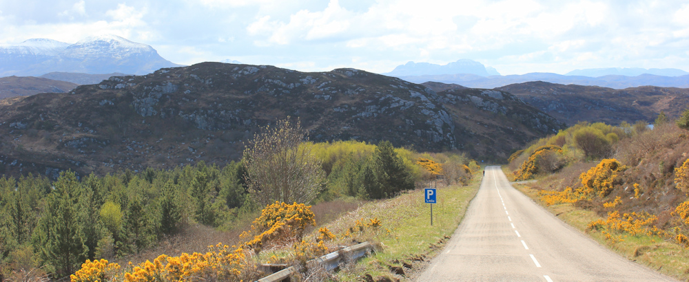
Onwards. Past a hotel and, after a long straight stretch, I realise there is another walker behind me. Can’t tell if they’re walking towards or away, but they never do catch up with me. There is SNOW on the mountains in the distance.
Yesterday, I drove up to Scourie in my van, having spent the night in a hotel in Inverness. (It’s the first time I’ve ever broken my journey up here – but I was told I had to “check in” to the campsite before 5pm, and I knew I’d never make it up in time for that. It’s a 12 hour drive.) Anyway, on the journey up, on the road beyond Ullapool, my van warned me about frost on the road. I’d never seen that warning light before… but, yes, there really was frost on the road. And then it started snowing!
Luckily the snow shower soon passed, but it was a warning about the weather in northern Scotland. In fact, my cycle ride down here was torture as I was freezing cold. I was wearing my winter coat and a woolly hat, but I didn’t think to bring gloves. At the end of the ride, I had to prize my fingers off the handlebars because they were so cold and stiff.
I’m really such an amateur!
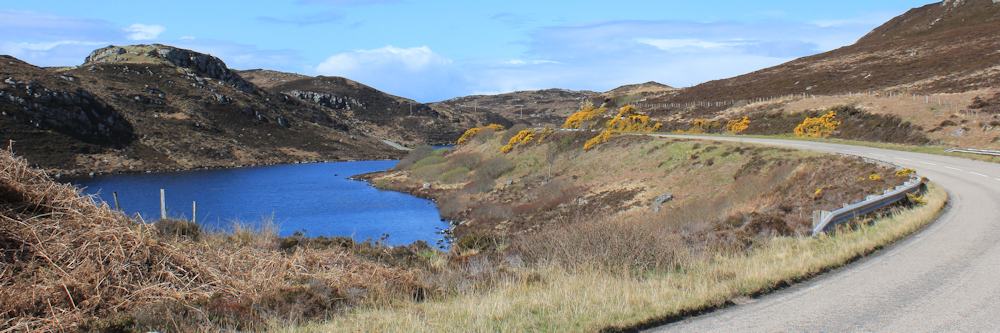
The road curves around the side of a lovely loch. Loch an Daimh Beag and then another loch, Loch An Daimh Mor.
Ahead is a parking spot beside the loch, with a picnic bench. I spotted it earlier, and was looking forward to eating my lunch here, but a big mobile home has pulled into the parking place. They’re not using the picnic bench… yet. And they have space in their van to sit. So, I hurry forward and nab the table, grateful for a rest and a chance to eat something.

I’ve just about finished, when a man emerges from the van and seems startled to see me. “How did you get here?” I told him I’d swum across the loch, but he didn’t seem to believe me. He was expecting a car or a bike… but I’d walked, of course.
A nearby information board explained how the earth’s land masses were once joined in one enormous island, before they floated off and became part of the continents we now know. The rocks around here are related to rock formations in Canada.
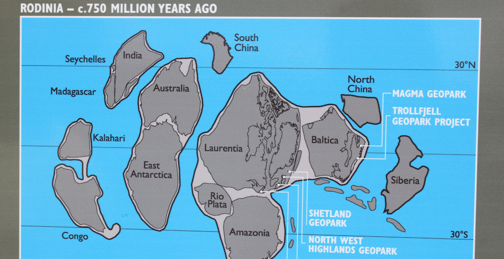
This isn’t new information for me, as I learnt about the connections back near Fort William, while walking down Loch Linnhe. Still, it’s nice to have a map showing how the continents were once arranged.
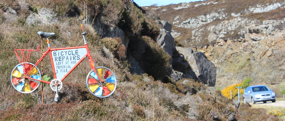
On a slope nearby, someone has placed an advert for bicycle repairs. Reassuring to know about, as there is virtually no public transport up here and I am very reliant on my Scooty bike. The advert is quite mesmerising, as the decorated spokes turn in the wind to give a kalaidoscope effect.
Further along, I come to the place where I abandoned last year’s walking trip. I remember parking my van here and getting my bike out, before realising it was much to windy to cycle safely, and deciding to pack up and go home.

(To be fair, I’d just had a horrendous night in my van at the Scourie campsite. I’d taken the top down because of the gale, but I hadn’t bothered to secure the straps – and it popped up in the night, lifted by the wind, with a most enormous bang. I didn’t get much sleep after that.)
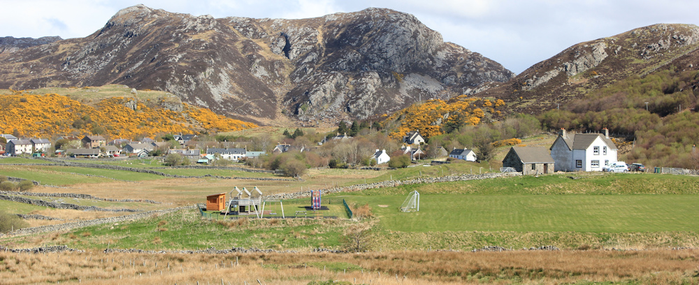
Today, with a light breeze and bright sunshine, everything seems different. There is Scourie ahead.

It’s a funny place. One of those scattered Scottish villages that is actually much bigger than it seems. The long gardens of the crofting cottages create a sense of space and emptiness in what is really the heart of the village. There’s a children’s playground below me, and a football field.
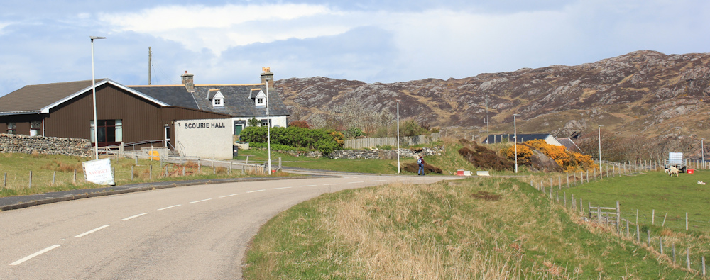
Lambs are playing in the fields. I stop to watch them for a while. Then walk past the school, the bus stop, a mobile library, a village hall, a community fire station, a church…
… and a side-road that leads down to the beach. Scourie Bay. The Gulf Stream channels water up the west coast of Scotland, coming directly across the Atlantic from the Carribean. On a day like today, it is easy to believe that I’m looking at a tropical sea. The water is impossibly blue.

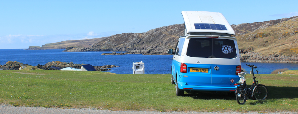
The beach is tempting, but I continue walking along the main road to where I’ve parked my van. After driving back to pick up my Scooty bike, I check in at my campsite – I arrived too early to do that before – and set up my van in its designated spot. My electric cable isn’t long enough to reach the power point, but the lady at the camp site kindly lends me a longer one.
A great view. And what a difference the weather makes. Let’s hope the wind stays calm!
Then I set off walking again, because I want to visit the headland just west of here. It’s called Rubha Shios, according to my map, but Scourie Head, according to a footpath sign. Two names for everything!
I head down to the beach. Pale sands. Blue/green water. So lovely.

The beach road ends at a cemetery. I hope this isn’t a prophetic omen! Here, I stop to take photos of the incredible views across Scourie Bay. There’s my campsite overlooking the water.

From here, a narrow path leads onwards. Seems ominous at first, because of being in the shade, but it soon widens out to become an easy stroll…

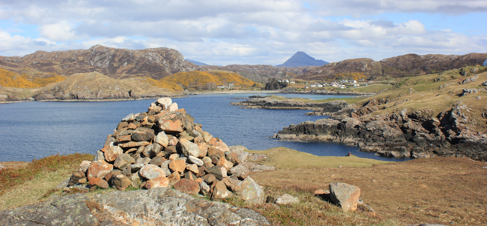
… until I eventually reach the cairn that marks the highest point of the headland.
I have mixed feelings about cairns – why do people feel the need to reorganise the natural landscape? – but this one makes a great counterpoint to the dramatic mountain peak in the distance.
I walk round the periphery of the headland. The mountains to the southwest are equally dramatic, with their snow-topped peaks, while the coast looks rugged with unforgiving rocks. What a contrast to the gentle bay on the other side!

Crossing back over the headland, I pass a pretty little loch that might be used for fishing. And I come across this whopping big stone which appears to be precariously perched on top of a flatter bed of different rocks. How did it get here?

Maybe it was left behind by retreating glaciers? These types of out-of-place rocks are called “erratics”. Who knew I would learn so much geology on my coastal walk?!
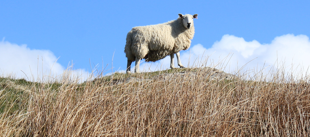
I ask a sheep for her opinion, but she just gives me a haughty stare.
Later, I rejoin the shady path that leads back to the cemetery, and stop to take far too many photos of the staggeringly beautiful views, before heading back up to my campsite along a path lined with yellow primroses.

One of the nice things about travelling up to Scotland, is that spring comes later than in England. So you get to enjoy all those springtime treats again – baby lambs and spring flowers.
Miles walked today = 7 miles
Total around coast = 4,871 miles
Route:


Welcome back Ruth, looking forward to more adventures in the highlands.
Hi Graham, taking me longer to write up than I anticipated, due to a whole load of recent media interest in my Killer Cows blog! Next installment coming soon, I promise.
Welcome back after your winter break, I’m looking forward to more adventures in Scotland. I’ve experienced springs in London, Wales, Devon and Stirling it’s be marvellous 2 month period!
Thank you Graham. It was lovely to see young lambs and spring flowers – despite the cold and the snow!
Welcome back Ruth and what lovely weather you had for this one. Yes I do find the insistence of so many camp sites that you must arrive before 5pm quite annoying (in fact it’s often after 3pm, before 5pm). It does limit choice as even when I’m only on a day walk I often won’t finish until after 5, let alone if you have any travelling to do.
I must admit I did not go out to Scourie Head/Rubha Shios. There isn’t a path marked on the map and I must have missed the footpath sign. Oh well something to get back to. I must admit when I walked this part of the coast I was a little jealous of that camp site at Scourie (I assume it’s the same one you stayed at), which looked beautiful and quiet. The one I was at in Durness was in a beautiful location but crowded and VERY noisy at night. If I hadn’t already booked and paid for the time in Durness I’d have been tempted to re-locate to Scourie after I’d been to Cape Wrath (my main reason for choosing Durness to stay). Mind you both Scourie and Durness feel like major metropolis compared with everywhere else in the area! I mean both have a shop and a pub.
As to double place names there is also the habit of re-using place names. You’ll get to another place called Badcall in a couple of days! (On the road to Kinlochbervie).
Hi Jon. I use maps of the core paths to find these unofficial offical paths. They aren’t always clear on the ground and so still very much “work in progress”. Many aren’t helpful becuase they go the wrong way or are dead ends, but useful sometimes. https://highland.maps.arcgis.com/apps/webappviewer/index.html?id=2fd3fc9c72d545f7bcf1b43bf5c8445f
What a beautiful walk. Love all the blues.
It was a magical bay. Although I guess it will look quite different on a wild and windy winter’s day.
What a gorgeous start. The water colour is amazing.
It was cold, but I was glad of the sunshine.
Terrific looking day and views – looking forward to your tomorrow!
Tomorrow is coming, Robin, and thank you for your kind words. I’ve been distracted by my Killer Cows campaign!
Lovely pictures too.
Hi Ruth good to hear from you and see a wonderful selection of photography. I congratulate you on the Kit Kat as a choice of snack, it’s either got to be that or a Snickers (really a Marathon bar !!) – Cheers Russ
It’s difficult to find a good snack with a long shelf life. Sadly my lunchtime picnics usually consist of a cereal bar and a chocolate bar, with a piece of fruit if I’m lucky 😀
Fantastic scenery. Good to see you more up to date with the posts. I wonder if it will be a month or two afterwards when we learn of your finish? I bet you are looking forward to turning right at Cape Wrath.
I was up for 5 weeks, Conrad, and determined to make progress. Hope you are keeping well.
Great to read your first post for the current year and what a lovely walk to restart your coastal adventures.
Yes, a lovely walk to kick off the season!
Welcome back Ruth, it’s great to read your first post for this year. You got some great views on this one, I love the view looking down the hill to Badcall Bay and the one heading down the lane to the beach. I know the colour of the water is just a reflection of the sky but it’s all such a gorgeous blue 🙂