
[This walk was completed on the 27th April 2023]
My plan today is an 8 mile hike – 3 miles across country from Scourie to Tarbet, and then a 5 mile road-circuit around the Tarbet area. So, I’ve parked in Tarbet and ridden my Scooty bike back to the campsite at Scourie, where I leave it looking rather lonely. Most of the other campers have left. At least my bike has a nice view.

After glorious sunshine yesterday, it seemed a shame to wake to damp drizzle this morning. Last night, the temperature dropped to 3 degrees. I was quite snug under my duvet with my unfolded sleeping bag on top – but woke in the middle of the night because the tip of my nose was freezing. I tried to flick on my little heater… only to discover that the power was off! Luckily the power came back in time for breakfast, which I ate with my fan heater blowing warm air onto my feet.
I have a new admiration for wild campers. Not only do they have to carry their tent and water and food and sleeping bags, but they have to endure the cold too.
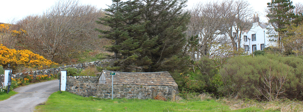
After making sure my bike is locked, I check the contents of my rucksack. Oh, no! I realise – too late – that I’ve left some important equipment behind in my van. Nothing I can do about it now, so I shrug my rucksack onto my shoulders and set off down the little road that curls around the end of Scourie Bay and leads towards the old pier.

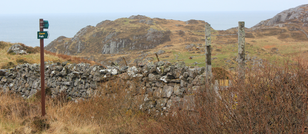
Just before I get to the pier, a Core Path sign points off to the right. You can see the finger post in front of the little old shed in the photograph below.
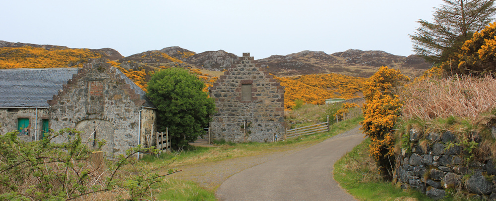
I follow an easy green path around the border of the field, and walk past some delapidated stone buildings (old stables?) that would make a wonderful redevelopment project, before joining a track.
Past some static caravans, through a gate and I follow the track across a flat valley. This looks too easy. Am I going the right way? Yes, there is a footpath marker on one of the gate posts.
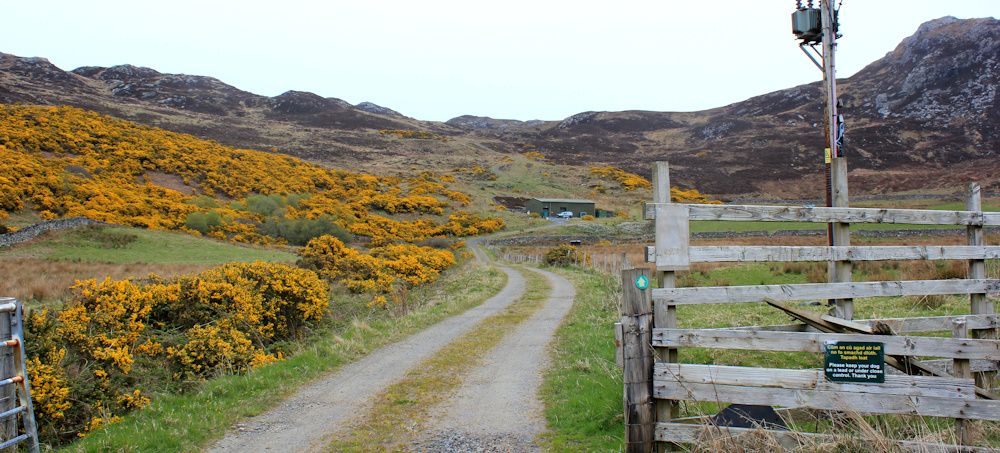
Near the end of the track I come across this sign. Oh dear. This route “requires a good level of fitness”, has “boggy sections” and I need “hill walking equipment” (not sure what that means).

I caught Covid for the second time last month, and it left me tired for several weeks, so I haven’t been doing my usual longish walks. Also, as I realised earlier, I have left most of my wild-country equipment in my van because I forgot to transfer it into my rucksack for the bike ride back to Scourie.
Left behind was my emergency orange bivvy bag, my paper map, and – most importantly – my personal locator beacon. But, at least I have my walking pole and plenty of water.
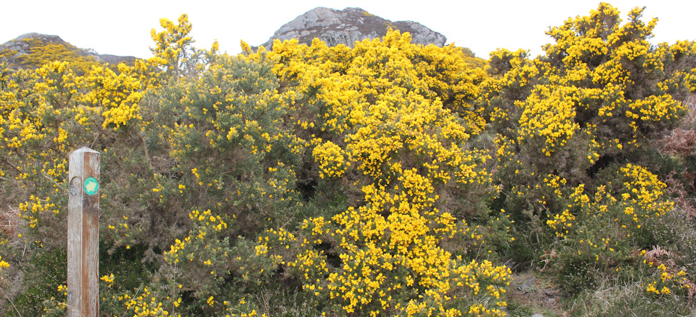
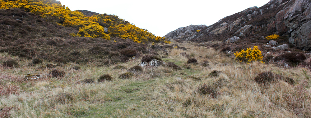
A Core Path sign points me in the right direction… into a thicket of gorse bushes.

On the plus side, gorse bushes smell divine – the best scent in the world, in my opinion. Honey and coconut and biscuits browning in a hot oven.
On the negative side, gorse bushes are as scratchy as hell!
At least the weather is so cold I’m wearing long trousers and a winter jacket, which give me some protection. Onwards and upwards.
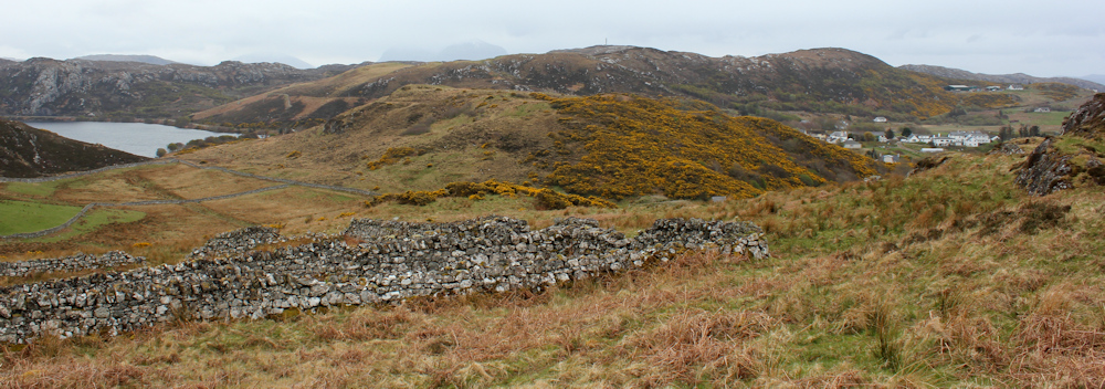
Coming through the gorse thicket, the landscape open up. Sad the weather is gloomy today, because my photographs don’t do the view justice. I’m looking out over an old sheep pen, with stone walls bounding sheep pastures beyond, and a lump of a hill (Torr Mor) sandwiched between a loch and a view over the village of Scourie. The whole vista is ringed with mountains, with their heads fading into the hanging low cloud.
Turn my back on the view and continue onwards. Upwards. At least the path is easy to follow on the ground and there are no bogs… yet.
At the top of the slope, I stop to take another photo looking back to Scourie. I’m out of breath from the climb, but don’t seem to have made much progress.

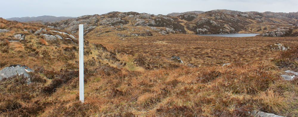
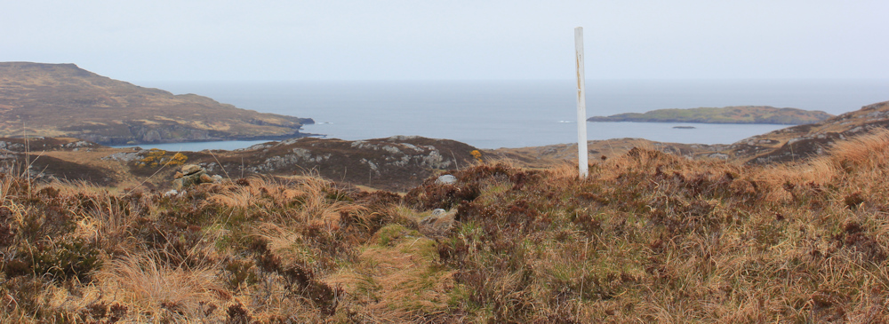
From here onwards, the path becomes less distinct on the ground, and I’m grateful for the odd white marker pole, indicating the route the path takes. [Later, when I can check my route on the map, this area is the Bealach an Eilein, which seems to mean the Pass of the Island, although which island is meant is uncertain.]
When the ground becomes boggy, the path disappears altogether. Every man for him/herself! Now, where is the next white marker pole…?

The path skirts one small lochan, and takes me towards a couple of lochs grouped together. “Lochain Bealach an Eilein” says my map, but I’m unclear if that name includes both lochs, or just one of them. I’m heading towards the edge of the water, where the path runs close to the shore.
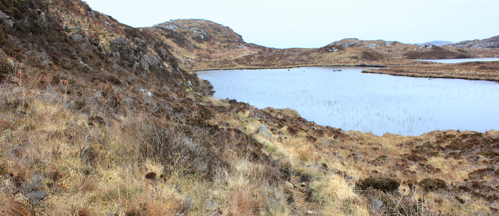
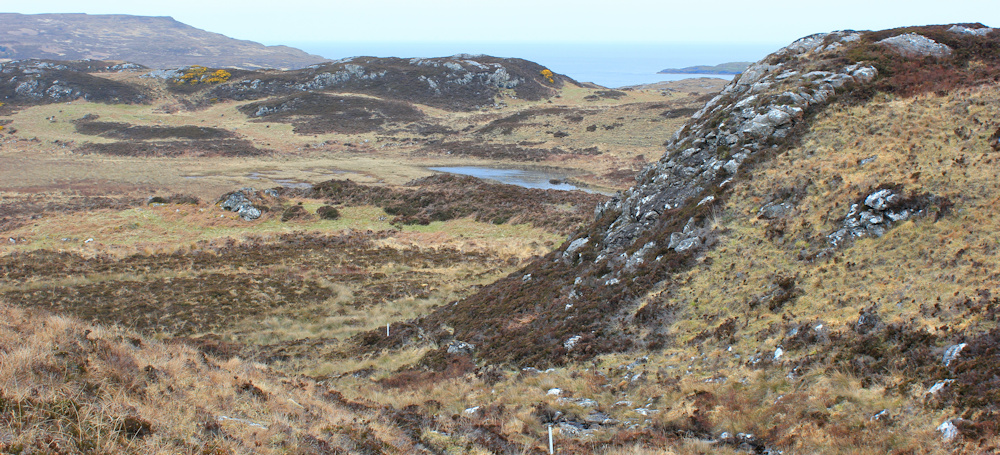
On the other side of this loch, I cross a narrow isthmus of land, where the two lochs are joined by a stream. It really is very pretty. I wish the sun was shining! On the other side, the path climbs the slope towards another white marker – you can just see it at the top of the ridge in the photo below.

This is a huge open landscape of jumbled rocks, tufty grass, marsh, and bracken. Scattered across the place are numerous lochs and lochans of various sizes, which the map seems to have given up on naming. The undulating land makes it difficult to see too far ahead, and yet the distances you can see across seem immense. There are no trees or bushes to act as landmarks – just rocky summits and pools of water.
It would be so easy to get lost here. Very easy.
Luckily, although I forgot my paper map, I do have my trusty Garmin which holds a map card of OS maps. So, I always know where I am, and my Garmin shows the path too, so I can tell if I stray too far off the route.
Up another rise, heading to another white pole, and… oh, there’s the sea! I’d almost forgotten this was supposed to be a COAST walk! It’s good to see it.
The path looks as though its heading for the shore, and I find myself clambering down a steep slope. Slippery stones underfoot, with patches of loose shingle, and occasional areas of mud – it’s a difficult descent. The harder the going, the more previous walkers have tried to find alternative routes, and so the path is indistinct with numerous branches.
Thank goodness for those white markers.
At the bottom of the slope, the path swings away from the coast, going inland once more. But, there is a well-defined path heading towards the sea and, for a few minutes, I think it might be possible to walk towards the coast… but then I realise it’s a false path.
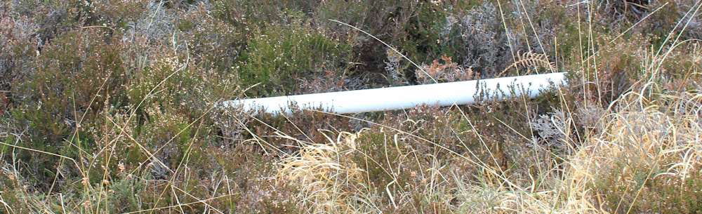
Near the base of the hill, a white marker post has fallen down. Coming down the slope, the route is easy to work out (as it always is when you are coming down a hill), but if you were walking the other way – from Tarbet to Scourie – you wouldn’t know the point to turn upwards.
The false path was created by the footfall of walkers who have missed the correct path. As my ex-husband once pointed out (correctly for a change!) false paths are more obvious than true paths because people have walked them twice – once when going the wrong way, and again when backtracking.
The fallen pole worries me. I’ve relied on these markers to find the way ahead. Although my Garmin will tell me if I get seriously off-route, the route of these remote paths is not always accurately plotted on the OS system.
Skirting a boggy lochan, the path leads on. Up and down and up again. The climbs aren’t particularly high or hard, but there are a lot of them. The marker poles are clinging on – despite sometimes leaning drunkenly and sometimes losing their tips because of (I presume) the weather.

In some places, people have construced little cairns. At first this seems odd, as the cairns seem to be dispersed randomly and not always at the top of significant hills, which is where you normally see them. And many of them are tiny. Like this one…

And then the penny drops. The little cairns are actually acting as markers – either unofficially or officially constructed isn’t clear, but they crop up where the white posts appear to have given up.
Down into a little valley, across another boggy area, stepping across a little stream, and then up the other side. The path continues.

At the top of the next rise is another view of the sea. I’m not sure what I’m looking at. Somewhere to the west, and to my left, is Handa Island, but the island aheads are too small to be Handa… so I think I’m looking due north across to… well, vaguely in the direction of Tarbet.
At this point the path is beginning to seem never-ending. I check my Garmin again. No, I’m not lost. Its just the effort of continually negotiating bogs, rocks, streams and slopes. That is why I’m feeling tired – and I did start the day with a 6 mile bike ride!
Another little cairn. The road is a track over the rocks and then a muddy scramble down across the next valley.

Here is an interesting old gate. It implies this area was once divided into fields. For sheep grazing, I assume, as can’t imagine you could grow crops here. Or maybe cows… but I’ve seen no sign of either sheep or cattle. Anyway, the gate is now rather superfluous and surrounded by open space, the fencing long since gone.

I sit on the flat rock by the gate, and have a drink and a snack. What a beautiful, wild place this is. I’m lucky to be alive and grateful for my good health and good fortune.
Onwards.
Here is a cairn to guide me up the next slope. Thank you to whoever put them here.

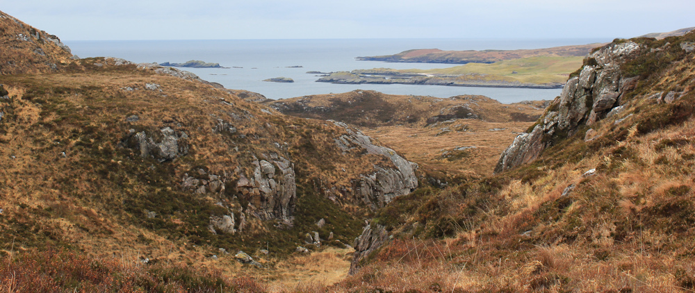
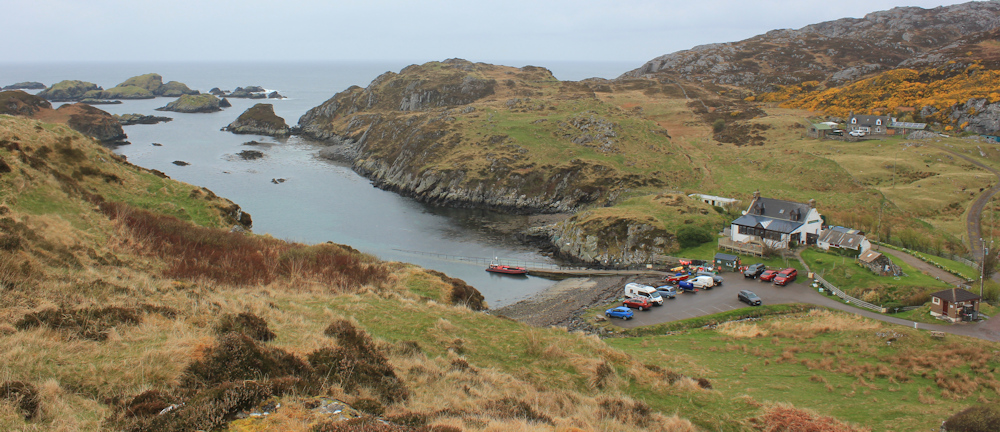
And – ah – finally, a clear view of the sea ahead. There’s a boat down on the water in some sort of estuary.

I look at my Garmin and realise I’m looking down at the entrance to the little port at Tarbet. Can’t see the harbour yet, but I must be nearly there.
The path turns away from the sea again. Oh well, still some distance to go – maybe this path really never ends! The mist around me transforms into a light drizzle, but I don’t mind, because I’m in the flow now, enjoying the walk, moving from one marker pole to the next, and finding the path is becoming easier and easier to follow.
It is a shock to come across something manmade amongst all this emptiness. A stone wall! Apart from the rusting gate, and the marker poles, it’s the first manmade structure I’ve seen since I left the sheep pen behind.
The path tracks along the wall to a gateway with a core-path signpost, where I walk through…
… and oh, what a view!
There’s Tarbet below me. How pretty it look. Basically just a few houses, including a cafe, and a car park for the people wanting to catch the Handa Island ferry.
I clamber down the slope, and this actually turns out to be the most difficult part of the walk, because the slope is very steep and the stones are wet with the misty drizzle that has surrounded me.
As I get further down, I get a clearer view of the ferry. Doesn’t look very large!

I stop at a picnic bench overlooking the little harbour and finish off the last of my snacks. But it is too chilly to linger.
I climb up a grassy slope towards a higher parking area, where I’ve left my van. The road down to the car park right at the bottom, by the ferry, seemed too steep for my bike this morning. And, in fact, I did have to push my bike up the first hill out of Tarbet. Not easy, beacuse that bike is very, very, heavy.
Ah, there’s my van.

Now, I was planning on doing the road circuit before ending my walk today. But, I’m cold and damp, and tired. So I decide to brew up some coffee in the van, and eat another bar of chocolate. Then, I realise it is raining harder and decide that is enough walking for today. I will tackle the road circuit tomorrow.
Miles walked today = a measly 3.5 miles (3.68 to be precise!)
Total around coast = 4,874.5 miles
Route taken:


Nice to read about your continuing walks in Scotland, but very sad to hear you have had COVID.
All the best for this summer, and hope you stay fit.
I did another walk on the SW Coast Path on Sunday, which was from Clovelly to Peppercombe.
You were right, part of that is tough going through Worthygate Wood!
That section is tough, Philip. Well done for completing it.
What a wild and beautiful walk. Don’t think I’d have the nerves for it but very inspirational.
It was a tough one and I felt nervous. But glad I did it.
Well done you for doing that walk. I chickened out of it when I was there and just followed the road although I did do the Tarbet loop on my way to Rhichonich. Just thought I might not make Rhiconich in a day if I took your cross country route – but it looks lovely!! Isn’t it interesting how places are called Tarbet / Tarbert / Tarbat in Scotland. Not surprising as it means isthmus. I must have been to at least 6!!!
I was nervous at attempting it, especially when I realised I didn’t have my beacon, but I enjoyed it. Surprisingly tiring. Tarbet also means meeting place or crossroads. Many Scottish names seem to be recycled!
Well done Ruth…I’m not sure whether I will tackle the Scottish coast…it looks far too hard & difficult…I’m off to Southampton tomorrow to fill in a few gaps on the South Coast, it won’t anywhere near as difficult as your walks. Cheers !
Hi Mike. Most of Scotland has been road walking, and I know some people (Andy, for instance) just stuck to the roads and avoided these paths altogether. In a way, it’s easier than the SW Coast Path, just goes on for longer! Best wishes to you.
” I’m lucky to be alive and grateful for my good health and good fortune.” My sentiments too. Keep it up.
I’m not sure if walking keeps us fit, or if we keep fit to keep walking! I’m just grateful for all the good things life brings me.
Exactly.
Hi Ruth – just adding my congratulations on completing that walk, especially when the dull light and general weather can also let the dreaded self-doubt come into play. What a beautiful remote location though – Cheers Russ
Thank you, Russ. I’m always full of self doubt when I do these remote walks. Can’t believe I left my beacon behind! Anyway, I made it.
I remember that gate in the middle of nowhere! I have a photo of me standing next to it taken in June 2009. Amazing that it is still there! We did that Walk the other way on a very hot day, and I remember we ran out of water before we reached Scourie and got very thirsty.
Unfortunately it is all just memories now. Colin, my husband and walking partner, is now living in a Care Home because his Alzheimer’s has got so bad. But at least we did it! Keep at it while you still can, Ruth, you never know what is round the corner.
Oh, Rosemary, I’m so sorry to hear that. Life is cruel sometimes. Sending best wishes to you both.
Ruth, you are truly amazing! What a walk to tackle on your own. Wonderful views though.
I felt a bit underprepared, to be honest, but it was only 3 miles or so! Still, it felt like quite an adventure.
Well done for doing the Scourie to Tarbet path!
I didn’t do it and went by road because – and you’ll appreciate this more than most – the path was blocked by some very excitable-looking cattle. I don’t normally mind them, but these were a bit too frisky to risk it. So, I skipped this bit due to cows and you’ve valiantly completed it; it’s a funny old world!
And I totally agree about gorse flowers; they are so coconutty!
Thank goodness for a Garmin. Sounds a bit hairy, you are brave. I started following Christian Lewis who of course actually followed the coast itself. But he is a big muscly expara. Amazing story as is yours.
Yes, I am in awe of the folks who actually stuck to the coast. It is not easy in Scotland. The terrain is very difficult and wild.
Well he scrambled over rocks and stuff I think and had to carry his dog at one point as the trees had been cut down. Then met a woman and had a baby. He will arrive in Swansea at the end of July six years after starting out. He has done all the islands too. He is writing his second book. I reckon there is a film in it. He had raised about £350k for SAFFA. The dog has become rather arthritic and has had to complete it riding in a van most of the time. Its a rescue dog. Its a bit comedic.
If there had been cows… I would have turned back!
An amazing walk. Beautiful views. We are so blessed to have all this!
We live in a beautiful country.
That looks like a lovely path, really looking forward to that! I wonder who built those little cairns to help guide the path, who would have the time while walking along there to gather all those stones and pile them up? It’s great that they’ve done it of course.
Whenever I come across a gate or a style in the middle of nowhere (and it’s surprising just how many of them there are), I feel obligated to go through it or over it. After all, it must be very lonely out there on its own, with no one even bothering to use it anymore.
Shame about the drizzle, it looks like an amazing place.