
[This walk was completed on Sunday, 4th May, 2025]
The forecast was showers in the morning, and sun in late afternoon. So, I decided to have an easy morning lazing around in my little apartment, and go for a short walk later. Inver to Portmahomack is only 4 miles. An easy amble.
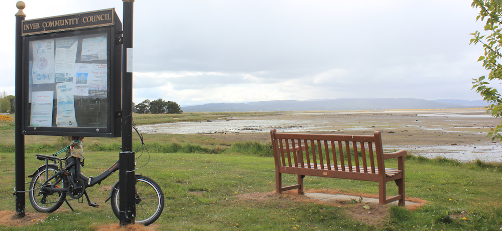
It is 4:30pm by the time the showers clear and I arrive in Inver on my Scooty bike, ready to resume my trek.
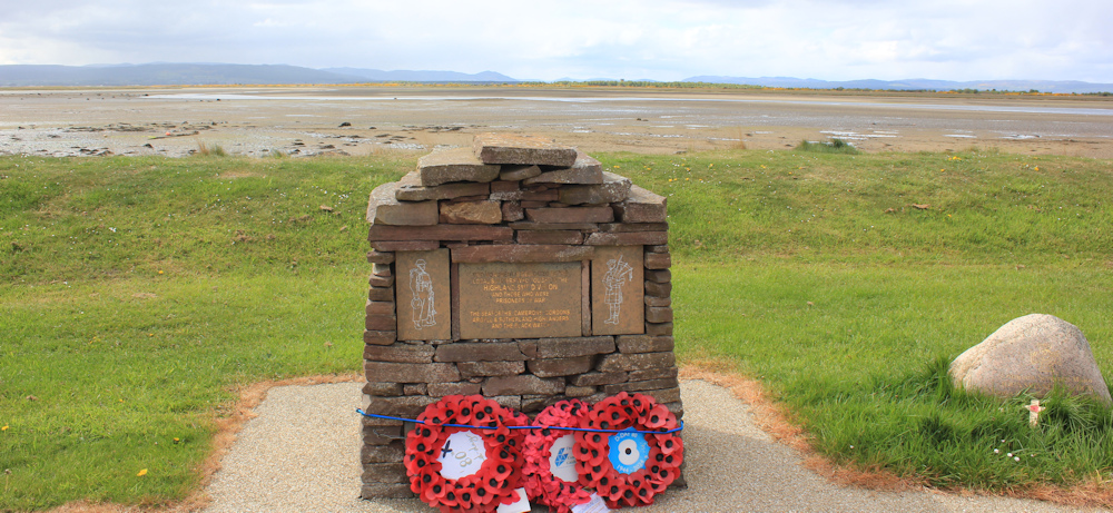
I know there is a cholera memorial somewhere in Inver. Very sadly, in 1832, half of the population of the village died from this awful disease.
At first, I think this construction, made from non-cemented stones, must be the cholera monument… but no, it’s a war memorial.
I look around, but there is no sign of another monument. Can’t waste time hunting for it in the village, I want to set off on my walk while the sun is shining.
The Core Paths map of the area shows a path around the shoreline of Inver, and a signpost indicates that this must be the route. The “Private Gardens” sign is a little intimidating, but I continue.

Yes, these do look like private gardens. A shed, a summer house, a boat, plant pots… but it also looks like a clear pathway runs right through them.

There is nobody around – not in the gardens and not on the beach. To be honest, it is not a very enticing beach at this point… mainly mud. But, look at the view of the distant hills. That must be Golspie somewhere over there.
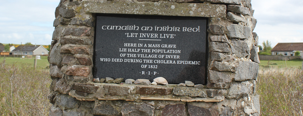
I leave the gardens behind and the path enters a wilder area. What is that ahead? Yes, it is the cholera memorial. I have found it after all.

“LET INVER LIVE” says the inscription. I didn’t realise that the monument actually marks the site of the mass grave where the victims were buried. How awful to lose half your community. Thank goodness we don’t see cholera epidemics in this country anymore. Good sanitation, and vaccination, have helped to eradicate this horrible disease from the UK.
I have been aware of the noise of motors – either dirt bikes or quad bikes, I think. So, I am not surprised when a trio of bikes come into view on the beach below me. The bikes stop and the riders appear to be discussing something. One lad gets off his bike and, after some more discussion, he begins to wheel his bike back towards Inver (maybe it is broken?) while the other two head off.

The remaining riders make slow progress navigating across the sand and mud. A quad bike appears from somewhere further up the beach, does a U turn, and disappears into the distance again.
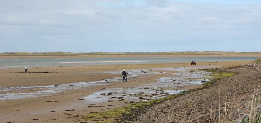
I remember the tracks I saw yesterday. I assumed they were made by mountain bikes, but I guess they were probably made by dirt bikes too.
The path becomes rougher, and I drop down onto the sands. Thankfully the mud is mainly confined to the lower half of the beach. This is nice sand.

More engine noises! This time it is a car driving along the sands. I didn’t anticipate so much traffic on this walk!

The car stops and a young lad gets out and begins to half-walk and half-run along the sands. Was he the guy wheeling his bike earlier? If so, why is he walking while everybody else is riding? Presumably because his bike HAD broken down.
The beach changes to an untidy mix of stones and sea-weed covered sand. The car, meanwhile, has done a U turn and is heading back to Inver. I guess it couldn’t make any further progress along the beach.
All is quiet again. Just me and the view… and a heron. He is in the centre of the photo above, but hard to spot. I take another photo on full zoom. There he is.

I always thought herons were fresh-water fishers, but I have seen a number on the seashore.
More noise ahead, and I realise a group of youngsters are having a BBQ – and possibly camping out – in the dunes by the side of a little river. I don’t take a photo of their rather untidy camp site, but this is where I cross the river, following in the tracks of their bikes.

It’s a bank holiday weekend, and what a nice way to spend the evening – in the wilds, on the beach, with your friends.
But they can’t sit still for long. Several bikes come up behind and overtake me, before turning and zooming back to the camp site. The quad bike makes another appearance, and is manned by two girls. Every biker who passes me gives me a cheery wave and “hello”.
One has obviously been showing off his slalom abilities on the sand. Quite a neat pattern.

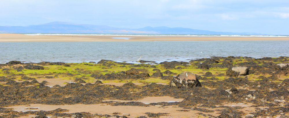
A little further along, and the beach changes character once more. The sand gives way to a rough mass of rocks, and the character of the sea changes too. Long rollers crash and churn at the water’s edge. I stop to take photographs of the foaming waves and the warm-coloured rocks.

The beach is becoming too rough to walk along comfortably. There is my destination, Portmahomack, ahead, but it will be a scramble to continue along the shore.
So, I take to a grassy track that runs just above the shore. Easy walking. And the sun is still shining intermittenty.

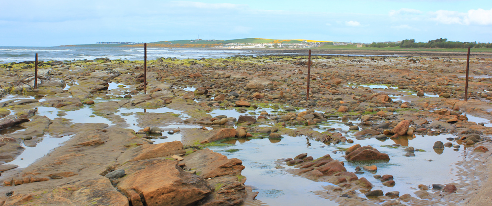
After a while, the path disappears where the low bank has crumbled onto the beach. Now, I must walk along rough shingle… but I’m nearly there.

I had never heard of Portmahomack before (actually, I’d never heard of Tain either) but it is a weird name. Sounds like an American Indian tribe.
Can’t get any further along the shore because the enclosed gardens of a private house extend right down to the shoreline, and the beach below this looks too rocky. But a path leads a few yards inland to the end of a road, and I can follow this road into the village.

At first, the road is lined with residential house, but further along there is a haulage yard with some huge lorries parked nearby. How do they navigate such a narrow road?

Right at the end of the road is a church and a caravan park.
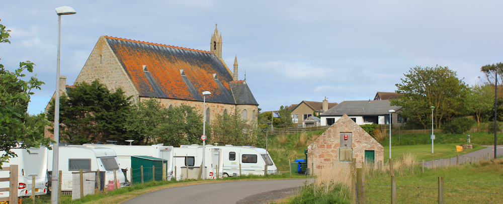
The park doesn’t look very inviting as the vehicles seem closely packed, but I guess they have easy access to the beach on the other side.
This weathered sign takes me by surprise. “Portmahomack Caravan Site” is straightforward enough, although the nearby religious statement is a little unexpected. Then I spot something at the bottom of the sign: “Operated by Tarbat Free Church.”
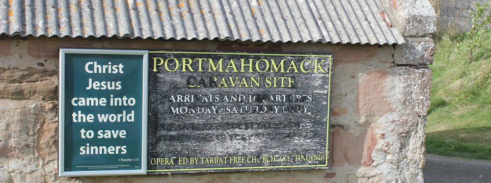
I wonder if the church simply owns the site and manages it, or whether it is a religious retreat type of holiday. My parents used to stay in Methodist Guest Houses in various seaside places – Scarborough, Eastbourne, Llandudno. All now closed.
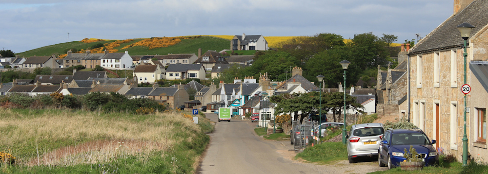
My little lane has joined the main road into Portmahomack. It is a pretty village…
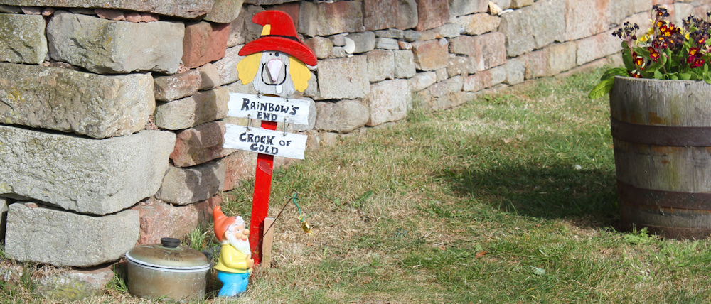
… with a penchant for gnomes! This is the first one I spot, fishing at the Rainbow’s End and catching a crock of gold. Makes me smile.
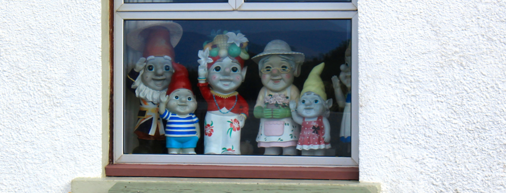
There are more gnomes in windows of another house. Hello! Quite a family.
I reach my van, parked in a beach-side car park. Sadly, the view is obscured by a line of dunes, but when I climb through a gap, I get a great view of the beach and the village.

The beach is north-facing and has lost the sun. I look forward to my return tomorrow.
I’ve brought a sandwich to eat for my evening meal, but it is too cold to sit out now the sun has dipped. And I don’t feel like sitting in the car park with no view, so I drive back to Inver, where I have to pick up my bike anyway, and where the car park has a stunning view (as in the first photograph at the top of this blog!)
Heron’s seen = 1
Gnomes seen = dozens
Miles walked today = a miserly 4 miles!
Total distance around coast = 5,190 miles
Route:


I just love reading these! Thank you for writing and walking. Theres a book in here x
Thank you for your kind words.
I’ve never heard of Portmahomack either! Nice little walk though 🙂
Wonderful name and a very pretty place.
That was a superb layered photograph of the coloured rocks, then rolling seas & looming distant mountains, under an almost brushed on sky.
Thank you Russ. It’s my favourite photo from this day.
This Walk I remember well as being one of the most enjoyable ones. Back in 2009, I think. There was no JOG trail then, we were walking ‘blind’! And loving every minute of it.
I admire your tenacity, Ruth, in bouncing back up and continuing after your terrible illness. Keep going, Ruth. You can do it, even if it is more slowly. Does that matter?
We gave up in 2021 — having walked from Bognor Regis to Manorbier the long way round, because of my health detrioration. My walking partner, best friend and husband since 1966 was as fit as a fiddle physically. This week Colin died after a three year fight against the terrible condition of Alzheimer’s, whereas my health is exactly the same as it was in 2021.
Life is a paradox.
I was so sorry to read your sad news, I had enjoyed reading your blog and remember thinking “wow” at your success with the Cape Wrath stretch.
So sorry to hear you have lost your huband, Rosemary. What an awful illness ALzheimer’s is, and how sad that Colin’s life ended so soon and in this way. We never know what’s going to hit us in life, do we? Thinking of you as you cope with this difficult time. Best wishes. x