
[Warning: For anybody following after me, the route of this walk is no longer passable. The river bank has been breached to create the Steart Marshes, and walkers would need to make an inland detour to get around the breach.]
Today I am heading down the west bank of the River Parrett to Bridgwater, the first point at which I can cross the river and continue my coastal walk.
But, when my husband drops me off in the car park at Steart Village, and just beside the monument that marks the beginning/end of the West Somerset Coast Path, I see a footpath sign. And I discover I can walk even further along the coast, and maybe get to Stert Point itself.

So off I go. (This is another unexpected eccentricity displayed by the West Somerset Coast Path – it doesn’t actually end where it says it does!)
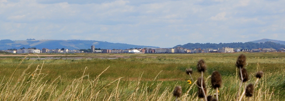
On the way I have good views across the mouth of the estuary. That must be Burnham-on-Sea. It looks enticingly near. But signs warn me not to attempt to cross the mud – it is treacherous.
Stert Point is given over to a nature reserve, but access is allowed as long as you keep to the paths. There are plenty of bird hides. It must be the wrong time of year, because I see no birds. Nor do I see any birdwatchers. Ironically, one of the hides is closed because of nesting swallows.
I can’t get to the point itself. But from the farthest hide, I can look over the estuary. I would like to think the rounded hill in the distance is Glastonbury, but my map says it’s called Brent Knoll.

There is a large hide on stilts at the entrance to the reserve. I climb up and enjoy great views over the countryside. This hide also marks the beginning of the River Parrett Trail. An information poster tells me to expect ‘a fascinating journey’ and promises ‘along the trail you will find work by artists and craftspeople’. Sounds exciting.

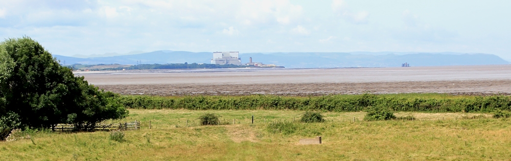
I take a photo through the glass window, across the mud of Steart Flats, to the distant hulk of Hinkley Point.
Then I walk along the track that marks the official start of the River Parrett Trail, although at this point the river is nowhere to be seen.
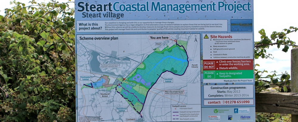
An information board shows a new scheme to manage flood risk and create an extensive marshy wildlife habitat. Work should have finished winter of 2013/14, but it is not clear if it has been completed or not. There are path deviations ahead. (Footpath deviations are something of a habit in Somerset.)
The first part of the trail is easy walking, if a little boring.
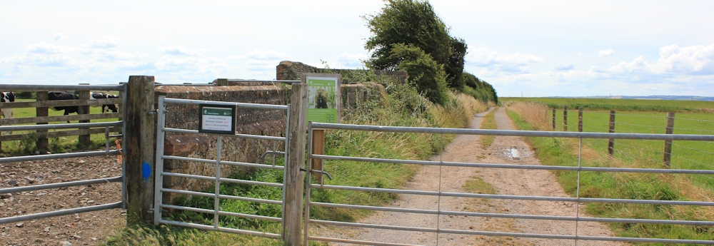
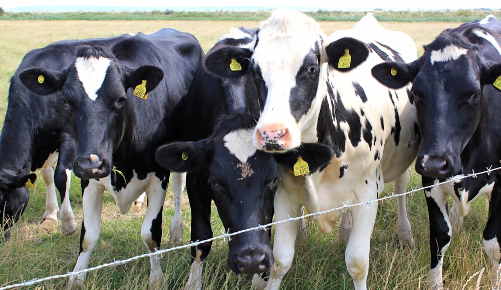
Things get interesting when I reach a diversion, and walk along an overgrown, narrow path around a field of cattle. They are, as always, intensely excited by my presence, but at least they keep to the other side of the barbed wire fence.
I stumble along, through thick grass, and am pleased to see the river ahead. On the bank, I assume, the grass will be shorter and the walking must get easier.
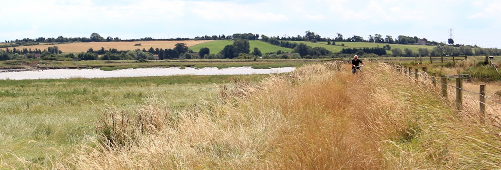
But it doesn’t get easier. I meet a cyclist (pushing, not riding, his bike). He is struggling though the grass and has come from Combwich – the only village on the river bank between here and Bridgwater.
When I tell him I am heading for Bridgwater, he seems surprised and tells me it’s a long way. I’m surprised that he’s surprised. Isn’t the River Parrett Trail supposed to be a long distance footpath?
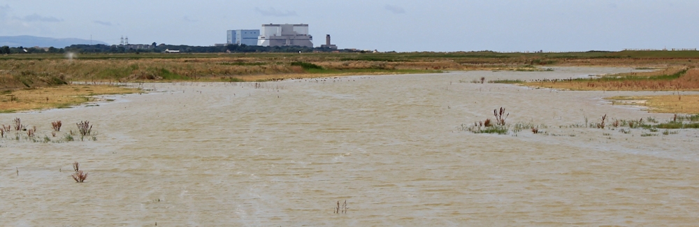
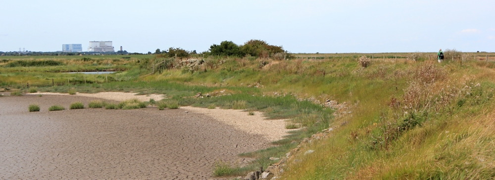
Further along, and I can see recently flooded land. Signs warn me this is a construction site – which I find amusing, as I it looks more like a wilderness to me. Beyond are the blocky structures of Hinkley Point Power Station.
A walker has been behind me for some time. He’s been whistling. Maybe to warn me of his presence? I stop and pretend to adjust my shoelaces to allow him to pass. He must have spoken to the cyclist, because he stops and says, ‘I hear you’re trying to get to Bridgwater?’ He also warns me it’s further than I think – because the river twists and turns.
Again, I’m surprised that he’s surprised that I am walking a long distance along a long distance footpath. I’ve worked out it’s about 12 miles from here to Bridgwater. He tells me he is going to Combwich.
The overgrown path morphs into a wide track. Much better! And I make good progress. Combwich is visible and grows nearer.

I stop for lunch at the Anchor Inn. But they only do a roast dinner on a Sunday. I don’t feel like a roast, but they can’t offer anything lighter. Shame. I have my usual ’emergency’ lunch, reserved for occasions when I can’t get food in a pub. A packet of crisps, a bag of nuts, and a pint of cider. Very healthy!

I tease the landlord, who only offers one type of cider. In Somerset?! He asks where I’m heading and I tell him Bridgwater. He raises his eyebrows. I ask if the path is very overgrown in that direction. He says he’s not met anyone whose walked from Bridgwater, and so he doesn’t know.
This is the third person who has expressed surprise at my plan to walk along the River Parrett Trail to Bridgwater. I am beginning to get worried.
But, when I walk through Combwich and find the continuation of the River Parrett Trail, it looks fairly easy. The ground is rough, but the grass is shorter and there are no brambles or nettles. Off I go.

I take a photograph looking back at the village. It looks very sleepy. But I know EDF has big plans to convert the small wharf into a dock for the transport of construction equipment to Hinkley Point Power Station.

[Combwich is going to undergo a massive change in the next few years. You can see what the dock development will look like in this YouTube video.]
Onwards.
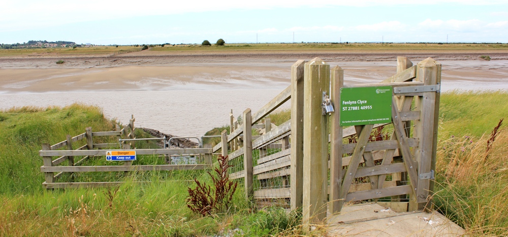
I wish I could say the landscape was interesting. The river is wide with muddy banks and a sluggish flow. There is no shipping. The landscape on either side is flat and reminds me of my old stomping ground, the Cambridgeshire Fens. There are familiar sluice gates and pumping stations. But the language here is different. Instead of sluice, the outflows are called clyce. They provide little focal points of interest in an otherwise featureless walk.
I pass by Tuckett’s Clyce and Fenlyn’s Clyce.
After Pippin’s Clyce, the path becomes very overgrown and walking is a real struggle. Sometimes I walk along the top of the bank, where hidden ruts and hollows threaten to twist my ankles. Sometimes I walk along the bottom, where the grass is long and my feet sink into its softness, like walking in deep snow.

This is the famous River Parrett Trail? I am disappointed.
To be fair, according to my map the Trail deviates inland at one point – but there are no visible signs to tell me where this happens. And when I come to a section that is definitely footpath (there is a sign on the gate), the going is no better. In fact, the gate is too overgrown with weeds to force open, and I have to climb over the fence.

At this stage, I have given up all hope of seeing anything interesting, or coming across any of the promised artwork. I just hope I make it to Bridgwater without twisting an ankle or getting hopeless entangled in weeds.
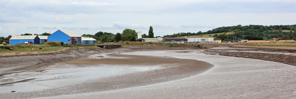
Ahead, on the other side of the river, is Dunball Wharf.
This is where large pumps were placed during the 2013/2014 floods to help pump water out of the Somerset Levels. The pumps were supplied by a Dutch firm.

The Cambridgeshire fens were created by the Dutch, who drained the flat landscape of East Anglia systematically and effectively. Our ditches were regularly cleared and the network of drains and sluices ensure the Fens are kept dry. Perhaps the Somerset Levels would benefit from more of those engineering skills and experience?
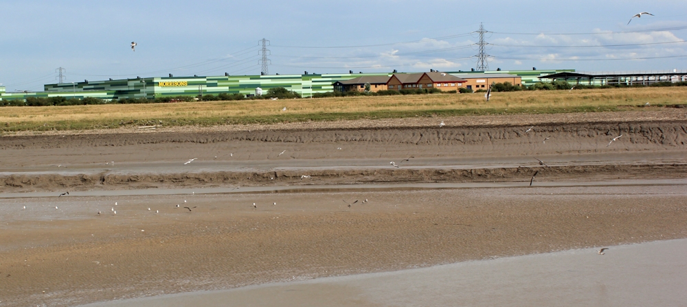
Further along, and there is a large industrial estate / warehouse complex on the other side of the river. Morrisons. And many others.
I have a harrowing walk across a field full of frisky bullocks (no photographs, because I didn’t dare stop) and reach a place called Pims Pill.

The name sounds pretty, but Pims Pill is narrow and deep, and lined by mud. I stop here and have a snack.

I meet some other walkers – dog walkers and strollers – for the first time. I am on the outskirts of Bridgwater. The path skirts around the edge of a sewage works. The pong is obvious but not too bad.

A footpath joins the Parrett Trail from an adjacent field. But the sign on the stile is a little off-putting. BULLFIELD. I can’t decide if the farmer has scrawled it, or whether some harassed walker has written it as a warning to others. I peer through the hedge, but can’t see a bull.

Anyway, I am sticking to the River Parrett Trail, and continue.
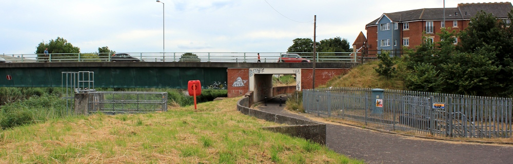
The approach to Bridgwater is rather tatty, but a welcome sight. The path goes through an underpass, under the A39, and then along the side of a housing estate. There is litter everywhere.
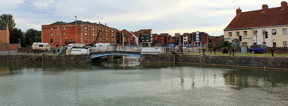
But I come to Bridgwater Marina. The wide outer dock is empty. And I am not surprised, because I find it hard to believe that the muddy river is deep enough to take any ships. It’s fairly attractive, as long as you ignore the discarded shopping trolley and bicycle in the sluice outflow.
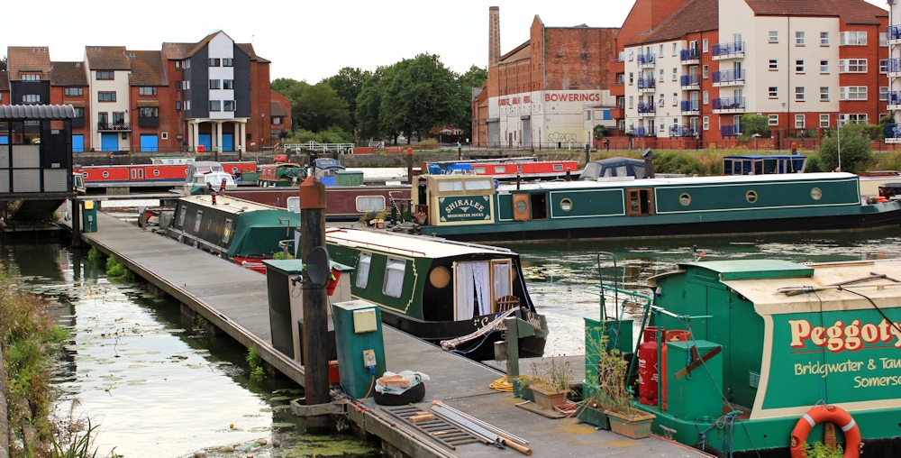
But the inner dock is full of houseboats. They look attractive in the evening light. It is a nice area, but there is nowhere to sit. I perch on a rock and wait for my husband to arrive.
Miles walked today = 13
Miles since beginning of my coastal walk = 1496
Route:


How strange that everyone expressed surprise you were trying to walk to Bridgwater when in fact it was only 13 miles (in fact less, because the 13 miles includes the first part of your walk). Good for you for pushing on. After 3 local people issued warnings I am sure I would have been having real doubts.
It’s very sad to find a longdistance trail that seems so unloved! And unused.
I wonder why all the people you met were so surprised you were walking so far? Perhaps it’s because most people hardly walk anywhere these days. Friends and colleagues have expressed surprise when I say I’m going for a ten mile walk and, to me, ten miles is not exactly ground breaking walking. What I pity the art work didn’t materialise either.
Weird, isn’t it?! 🙂
I’m glad to see you made it through, as I remember being told almost a year ago that a part of this route was impassable. Looking back, it is because of the Environment Agency’s ‘Steart Peninsular Project’ but diversions were apparently made available.
It was barely passable I was a bit disappointed, because I had heard how wonderful the Parrett trail is supposed to be. Maybe it will improve when the wetland construction project is completed.
Pingback: 155 Pawlett to Burnham on Sea | Ruth's Coastal Walk (UK)
Came N up this stretch yesterday (15/11), reversing your route. Bridgwater to Combwich all very straightforward and fast, if muddy in places. Saw no one and found gates sealed by spider’s webs, proving that it’s little walked.
North of Combwich you pass under a pylon line, which crosses the river. Immediately afterwards the path splits, with one dead-end route marked as going to the breach. The other swings L inland in a long arc, following the new raised bank, but generally below it. It passes car parks at Marsh Farm and Steart Gate before emerging at Steart village, a quarter-mile short of Cox’s Farm. There are occasional ramps to birdwatching hides on top of the bank. Throughout, it is wide, gravelled, suitable for baby buggies, wheelchairs and suchlike, and richly signposted with the acorn symbol of a National Trail. Acorns have a footnote saying ‘English Coast Path’. In other words it is quite unlike the Somerset obstacle course that we all come know and love….. There are also marked ‘Camera Points’, selected by someone who does mind pylon lines across his photos.
Thank you. Good to hear the new route is operational and navigable! Let’s hope it is well used.
Anyone walked between Steart and Combwich recently please?
Ollie walked this section in April. https://ollypj.com/2016/04/24/dunball-to-steart-somerset-coast-path/
I did it today. No problems
Thanks for info. Can’t believe it, but I finally got to walk it last week too. Yup it’s fine. Except pretty hard going through that stretch of tall tight summer growth grass after Combwich. Very hot too. In fact, so hot I had to carry the dog for a good half hour. Not to mention rucksack of camping kit! I actually walked from Bridgwater to Doniford Halt station.
Sounds as if the path is still overgrown and not much used, despite the new diversion now in place. And that was basically the same problem I had. Anyway, very well done – both Andrew and Ed – for completing the walk and posting here.
Hi Ruth.
As others have described, the trail from Steart towards Combwich is now beautifully presented. I suspect that the twitchers lobby is strong in Somerset; money seems to be available for this and other bird sanctuaries, whereas the council’s maintenance of walkers’ footpaths is a disgrace.
Between Combwich and Bridgwater the path is more easily passable at the moment than it was when you came this way, although there’s a mile or so of tussocky walking where you have to mind your feet. Not a place to twist an ankle … between Combwich and Highbridge, outside of the bit inside Bridgwater, I met precisely one walker. Chicken and egg maybe; if the path was better, would the walkers come?
John
Hi John. I guess the new section has to meet the high standards expected of the England Coast Path, which might explain why it’s beautifully presented! And I agree with you about the chicken and egg problem. Footpaths that are difficult to walk end up not being walked, which makes them difficult to walk… etc.
The path is a disgrace between Dunball and Combwich with grass and weeds 3 ft high. I walked it today 31/05/2017 and in parts could not even see my boots but only fell over once. Blackthorn grows around the galvanized gate catches and its head down most of the time looking at the uneven ground if you value your ankles.Regards Gary
Hi Gary, and thanks for giving an update on the state of the path. What a shame! It’s supposed to be part of the famous River Parrett long-distance trail and you would think it would be better looked after. 😞
Dear Ruth
I walked Bridgwater to Steart Marsh this week. It is now signposted with green England coastal path signs. Currently there are three minor footpath diversions: the embankment opposite Dunball Wharf is being strengthened following change from arable to pasture – alternative route poorly signposted and hampered by farmers sowing crops right up to the hedges. Each field boundary has a wide drainage ditch and double hedges but heading for left hand side of soil mounds landed me onto farm track that led back to river bank albeit into a herd of bullocks.
There is work being done at Stallington Clyce. Looks like the dyke is being raised and strengthened to reduce flood risk to Cannington along the substantial brook.
At Combwich Quay work is also underway to renew the water main which goes under the Parrett: diversion is well signposted and brings you out at Combwich Pill.
Nettles and long grass on the path along Pims Pill Reach make going very slow and deterred a local dog walker and jogger. Between Starsland Clyce and Pippins Clyce the path was obscured by waist high grass and thistles. I met just one couple coming the other way who had battled through from Cannington on the way to Bridgwater.
Walkers beware The Anchor Inn isn’t open till 5pm Monday to Thursday.
The Wildfowl and Wetland Trust have done an amazing job creating pushchair and cycle friendly paths around the three new marshes on the Steart peninsula south of the breach: the coastal path and Parrett trail are permanently diverted now to the main WWT car park on Steart Drive close to Marsh Farm. A map of the area on the approach from Combwich would be a welcome addition to the glossy signage provided courtesy of Viridor working with WWT and the Environment Agency.
Hi Viv, and thank you for this detailed update. Sounds like sections of the path remain unloved. Such a shame when they’ve gone to a lot of trouble in other area! Best wishes.
I have now logged the overgrowth as Issue #44557 and Issue #44558 on the Somerset Council interactive map. They promise updates as they take action with the relevant landowners.
That’s great news. Fingers crossed.
It’s a real shame that some of these paths are almost impassable, it must surely deter anyone local thinking of going for a walk. At a time when we are all being encouraged to walk more byt the NHS and the government it’s a disgrace.
Totally agree. And a 100% worse with a small Westie. In fact I had to carry her for close on a mile, as she simply couldn’t carry on pushing through the dense grass, on top of a backpack as we were wild camping. A very challenging struggle is apt description! The before and after section was brill though…….
Oh dear. What a shame to learn there is no improvement. Andrew, it might be worth reporting it to the local council… again!