
This day’s walking turns out to be wonderfully varied – from beach to estuary, from woods to marshy fields, from footpaths to busy roads. But I will start with the morning’s trek along the sands and forest trails of Pembrey Park.

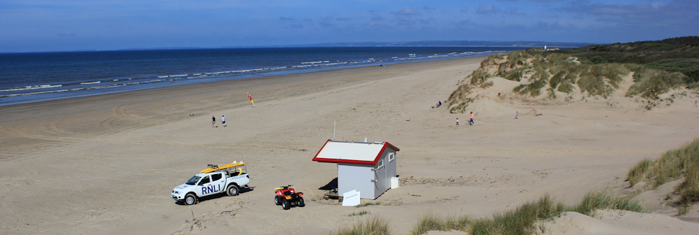
I’m standing on the Cefn Sidan sands at Pembrey. It’s a glorious day. The sun is shining and the air is clear. And so, for the first time, I can look across the mouth of the estuary and actually see the details of the Gower coastline. This is what I’ve been waiting and hoping for.
I climb up onto the top of a dune for a better view. There is Rhossili Down, with Rhossili beach hidden behind the finger of Whiteford Burrows. And the furthest rocky outcrop is Worms Head.

I take too many photographs, as usual, knowing this might be the last time I have clear sight of these old friends. Then I turn and look northwards, over the lifeguard’s hut, and towards the next estuary, and feel the usual thrill of excitement. There is so much of the Wales coast yet to come!
[Later, when I look at the full-size version of the photograph above, I realise I can see a tremendous distance, thanks to the clarity of the air: to Pendine, Amroth and Tenby. In fact, I can see all the way to the start of the famous Pembrokeshire Coast path!]
But first, I have this lovely beach to walk along and I ‘m determined to enjoy every moment. It will be wonderful to walk along a proper beach again. I’m planning to stick to the sands for as long as I can.
The tide has just turned and I walk along the still-wet high tide mark.

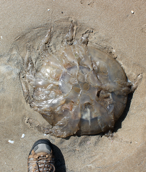 The first thing I notice is the number of jelly fish that have been left stranded.
They are huge. I take a photograph of one beside my foot, to show the scale.
Part of me wants to lift the things up and carry them out to the waves. But I have no suitable implement with me. And, in any case, I can’t rescue them all.
Also on the high-tide line are clumps of shells, still varnished with a glistening coating of sea water, making them even more beautiful than normal. They are enormous too – razor shells and clam shells. I think.
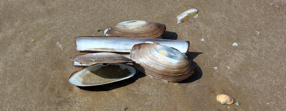
It looks as though someone has purposefully arranged them in an artistic way. But they’re just how the waves left them.
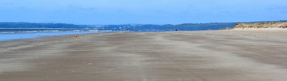
The beach is long and, even though I’m starting from part of the way along it, I have four miles to go. The far end is taken over by the military and by a ‘Aerial Firing Range’ – according to my map. After an hour of walking, and with my camera on full zoom, I can just make out the watchtower that guards the forbidden section from public intrusion.
Before I reach the military area, I plan to turn inland and pick up one of the tracks through Pembrey Forest.
But I must confess to being a little confused. When I set off this morning, a signpost in the dunes indicated that the Wales Coast Path ran along this beach. But my OS map shows the official path as meandering, a mile or so inland of here, through Pembrey Forest.
It doesn’t help that I’m approaching the edge of my OS Explorer 164 and will need to switch to OS Explorer 177. There is real excitement when I cross the edge of a map. It means progress and new territories. But I often find these transitions confusing, particularly if the coastline winds and curves. I can’t fix a mental image of the layout of the route in my mind. I’m not sure if other walkers have this problem – or is it just me?
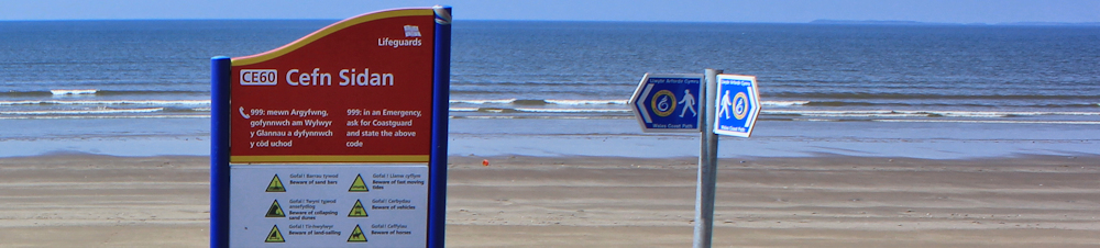
I’m still walking close to the high-tide mark, when I suddenly spot a red sign peeking over the top of the line of dunes that mark the edge of the beach. I head towards it.

And next to it I find the familiar Wales Coast Path sign: blue and yellow with the dragon shell. It points inland. Yes, definitely time to leave the beach.
The beginning of the path looks promising. I anticipate a meandering walk among trees.
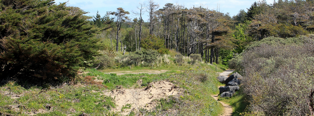
But I soon find myself on a wide, straight and boring track. Tarmac is hard on the feet. It’s designed for vehicles. Or for cyclists…

… but not ideal for walkers. In fact, I only meet one fellow hiker along the way – someone I see coming for many minutes before we pass each other. He’s an older gentleman and seems too weary to acknowledge my smile.

I decide to get on and finish this section as quickly as I can. Stow my camera away. March onwards.
And suddenly a large bird glides overhead. It seems larger than a harrier and the wrong shape for a kite (and I don’t know if there are any kites in Wales). Is it a buzzard? I’m hopeless at identifying birds. By the time I pull my camera out, it’s gone.
Side tracks lead off into the forest. They’re all wide and business-like too. Signs warn of Troops Training. And I remember I’m close to a military zone.

It’s a relief to come out of Pembrey Forest and free of the trees. The landscape opens up. I turn off the track, along another track, following signs. This is both the Wales Coast Path and National Cycle Route number 4, running between Fishguard and London. (London?! The city seems a world away!)

I come to a field of bullocks. They seem very large. Almost adult bulls.

Always wary of cattle, I have difficulty making progress because a number of enormous bullocks have decided to stand on the path, blocking my way. I edge, cautiously, around the group, stumbling over hidden dips and potholes in the ground, too nervous to stop or get my camera out.
The bullocks stare belligerently at me. Once seems to be pawing the ground. My heart is pounding by the time I reach the gate that takes me out of the field and up onto a bank.
Then I see a cyclist coming along the path through the same field. As he approaches the bullocks, they stand their ground. It’s like a game of chicken. At the very last minute they bolt out of his way.
He has to dismount to lift his bike through the gate, and he stops for a chat.
‘You’re braver than me,’ I tell him.
‘They always run in the end,’ he says. ‘Perhaps one day I’ll push my luck too far.’
He’s a local man and has decided to ride to Kidwelly and back.

Now the track follows a raised route along the edge of marshy land. I’m heading inland to where I can cross the Gwendreath River, and I’m dismayed when I see more cattle ahead, but this time they are safely tucked behind a barbed wire fence.

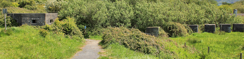
I come across remains of WW2 defences: a hexagonal pillbox and a line of antitank obstructions. I think of how warfare has changed. I don’t expect those concrete blocks would halt modern tanks for very long.
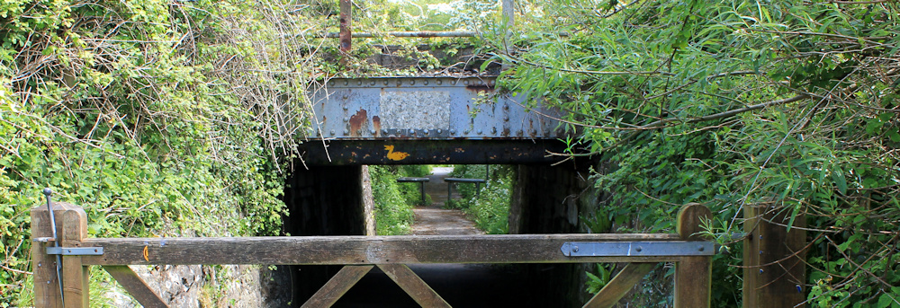
Beyond this is a low bridge, carrying the railway line. At first I wonder why someone has vandalised the bridge with such a neat piece of graffiti – a yellow duck. Then I realise you should take the sign literally. You must duck or risk serious concussion!
Beyond the duck bridge, and I join the A484. How many times has my path crossed and re-crossed this road? This stretch of walk is cheerful, despite the traffic, because of the roadside flowers and the Otters Crossing sign.

Sadly I don’t see any otters. By now I’m getting hungry. It’s time to find somewhere where I can sit down and eat my lunch.
[To be continued…]


I think they re-routed the path as Pembrey Forest poses some difficulties during winter. Such as a little bit of flooding.
Of course, unlike me, you had more sense than to walk it in January.
Oh wow! That’s a lot of water. Forgot about rain and mud 🙂
Glad you’re still enjoy your walk. Pembrey Sands are a fascinating part of the coast aren’t they? 8 miles of lovely sandy beach, dunes are a SSI while RAF Tornados use the firing range for target practise!
I was hoping to see a Tornado, or any kind of military action. But it was all quiet when I was there.
The beach looks womderful, although I find on long wide beaches like that I tend to lose the sense of progress. It can feel as if you’ve been walking for hours and hours and haven’t got anywhere at all. I like the duck bridge. I wonder how many people have hit their head while wondering what the graffiti meant?
The duck sign was almost too clever. I nearly missed the meaning completely! And you’re right about beaches. The lack of perspective can give the illusion you’re walking on a never-ending sandy treadmill. Love them anyway 🙂