
It’s a Sunday and there are no buses running in this part of Anglesey, but today I won’t need a bus. I’m simply going to walk all the way back to my hotel. And so I drive to the village of Llanfaethlu and park my car, knowing I won’t be able to get back to it until tomorrow. Then I start along the road towards the coast…
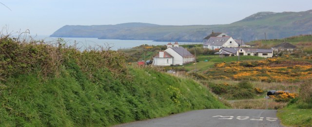
… and pick up the coast path again. It runs along the top of the low cliffs, past residential houses – mainly holiday homes – dotted about along the shore, overlooking the beaches.
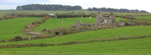
To my right is farmland with cows and sheep enjoying the lush grass, and ruined buildings among the fields.
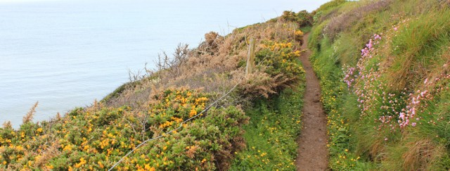
The coast path is lovely at this time of year (May), dotted with spring flowers and scented by gorse.
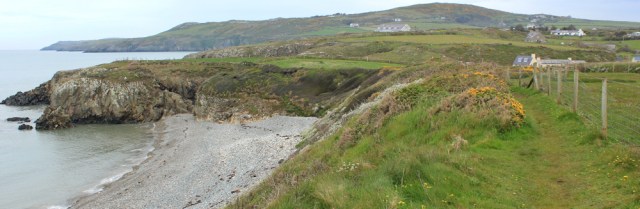
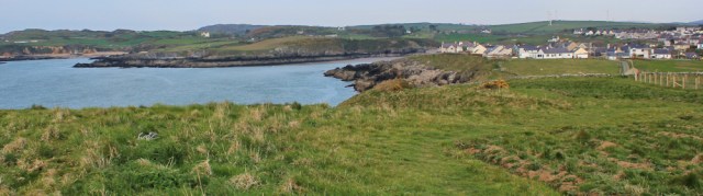
I soon reach Porth Swtan, otherwise known as Church Bay. The reason for the name? A grey church perched on the hill above the sea.
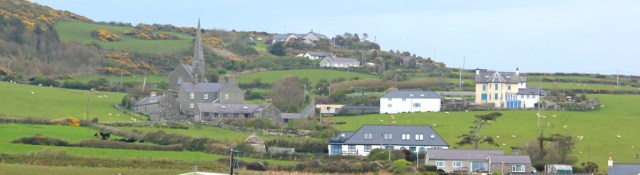
There are car parks in Swtan and people are arriving for Sunday outings. Mums with push chairs and dads with toddlers are milling about, and there’s a café by the path, smelling of bacon and coffee. Very enticing. But it’s much too early to stop for lunch.
I’m always amazed how reluctant people are to walk any distance from their cars. A hundred yards or so beyond the car park, and I’m alone again.
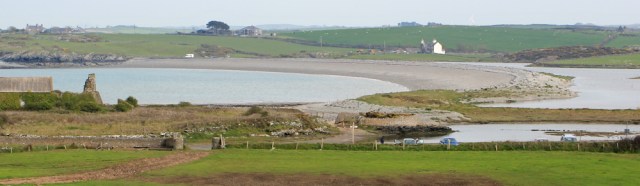
I take a photograph looking back at Swtan and, in the distance, Holyhead Mountain. Soon I’ll be rounding the headland at Carmel Head, and this will be my last day of seeing that familiar landmark.
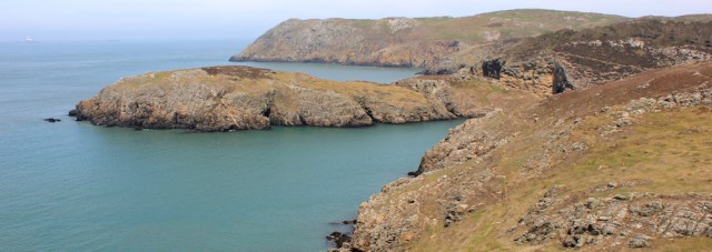
The morning started dull and hazy, but the light gradually improves. It’s a lovely part of the coast with a remote feel – a mixture of rocky outcrops and softer grassland, above an unspoilt coastline. No more houses now. Just me and the path.
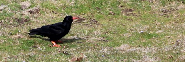
And crows… no, wait, too sleek for crows and with those red beaks and feet… choughs. This one is reluctant to leave off hunting for worms in the grass, and allows me to come close with my camera.
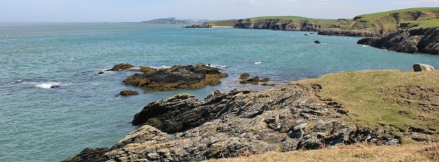
Ahead the coastline is rugged, with only the occasional tiny beach hiding among the rocks.
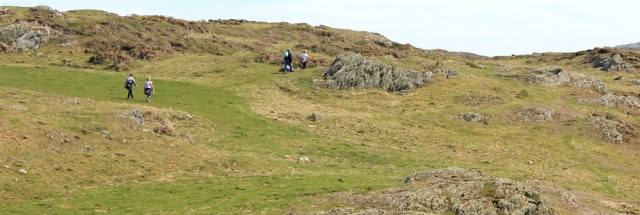
I see a few other walkers in the distance, but they are following an inland route and, because I’m hugging the coast, our paths never cross.
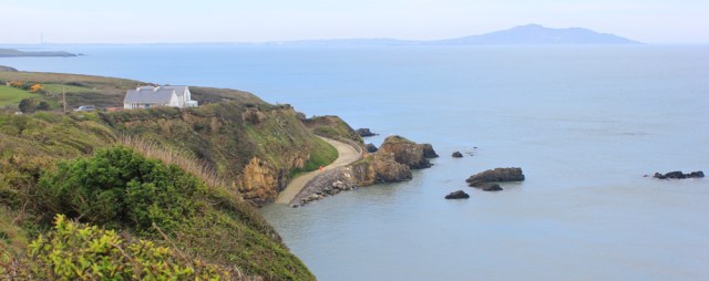
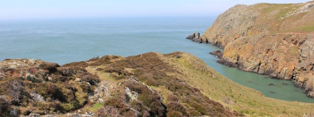
Anglesey is full of surprises. I round a corner and come across a wonderful little bar of beach. It’s a delightful sheltered bay, with clean, blue water, and I’m not surprised to see a few other visitors walking around. And a couple of men in kayaks – they seem to get everywhere.
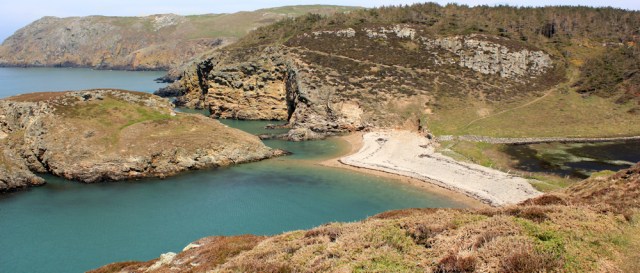
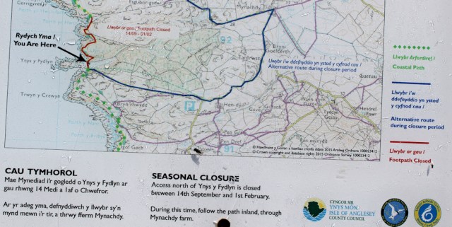
What is this place called? The headland is Ynys y Fydlyn. The little patch of inland water is labelled Llyn y Fydlyn on my map. It looks like it should be National Trust property, but it turns out to be privately owned.
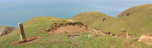
A sign explains the mystery of my OS map: which shows two possible coastal path routes across this area. There are, indeed, two routes. One is only open in spring and summer. In the autumn and winter you have to follow an inland diversion.
And, as I climb the headland, I realise why this path is closed in the winter. The way is steep and narrow, with a drop down to jagged rocks below. It would be treacherous in the wet, or if there was frost or ice on the surface, or in a howling gale, or if a sea mist closed in.
But today the weather is kind and the views from the top are wonderful, even if the distance is lost in a blue haze.
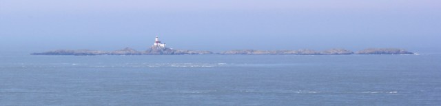
Out to sea is a line of rocks and a lighthouse. I check my map… The Skerries. I wonder how many ships have been wrecked on that barrier?
Onwards. I’m walking across open grassland, heading for Carmel Head. I meet a group of noisy geese and find I’ve strayed from the path, and have to duck under a fence.
Carmel Head, when I get there, is a disappointment. It’s a wide slope of open land, and the areas near the sea are marshy and mostly fenced off to deter wanderers. I was expecting to meet other people but I have the place to myself. I was also expecting some kind of information board, or marker point: a ‘This is Carmel Head’ sort of thing. But I don’t come across anything except some old ruins and weirdly shaped shipping waymarks.
I was also hoping to find some benches, as I want to stop for lunch, but there is nowhere to sit and the ground here is soggy and not very enticing. Also the wind has picked up and there is nowhere sheltered to sit. And I even had faint hopes of an ice cream van, or a small mobile café. But there is nothing here.
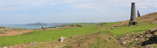
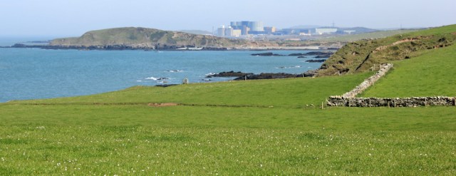
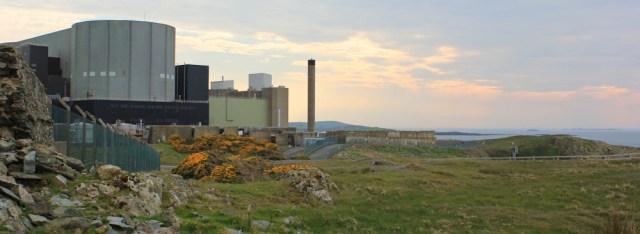
Leaving Carmel Head behind, I head eastwards. The coast stretches away, indented with little coves, and in the distance I can just make out the bulky mass of the power station at Wylfa Head. Cemaes is just behind the power station. I’m nearly there! (This last thought turns out to be incorrect.)
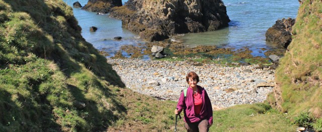
In one of the little coves, I hunker down for lunch. And even manage a self-portrait.
The rugged coast gives way to gentler fields. Daisies everywhere. And ahead the mass of the power station is growing nearer.
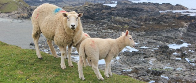
I meet sheep and notice, again, how bold Welsh sheep seem to be. This mother with her two lambs seems determined to stand her ground. Actually, as she is on the edge of a cliff, perhaps she has nowhere else to go?
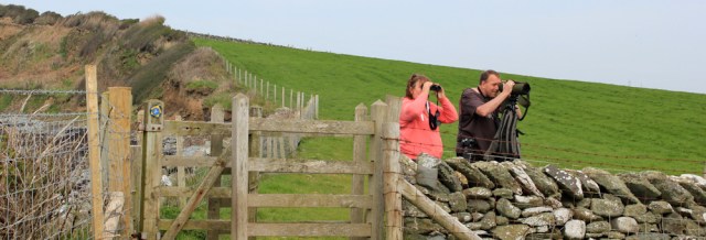
I begin to meet other walkers. And a couple of twitchers with binoculars. She has a small pair. He has a large monstrosity. They are looking for yellow somethings – was it yellow hammers? Have I seen any?
‘I wouldn’t recognise them,’ I say. ‘What do they look like?’
‘They’re bright yellow.’
Doh. Of course.
I leave the twitchers and come across another surprise – a wide sweep of shingle. It’s a mini Chesil Beach, complete with a mere behind it. This is Cemlyn Bay.
I walk to the tip of the flat headland, Trwyn Cemlyn, before heading down towards the shingle. There’s a car park here, and several people are walking their dogs. I cross over a rather ugly bridge and onto the shingle bank.
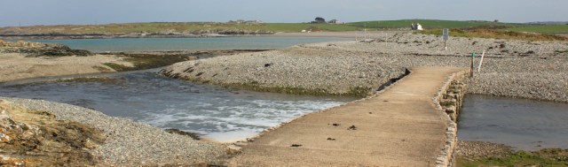
Signs warn me that birds are nesting on the flat strip along the top of the shingle, and I must keep off the top. So I’m forced to stumble across the slope of shifting stones. It’s hard work. In fact, very hard work. If I’d known it was going to be so difficult, I’d have followed the alternative route along the road.
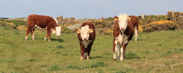
I get to the other side of the shingle bank eventually, and now the path leads up through fields. I watch these cows warily. They can’t keep their eyes off me either. I seem to have an inbuilt cow-magnet.
The next stretch of coastline is beautiful and empty of people. I take photographs of the power station, whose hard lines are softened by the hazy light of the afternoon, enjoying the juxtaposition of the smooth manmade structures against the craggy chaos of the rocky coastline.
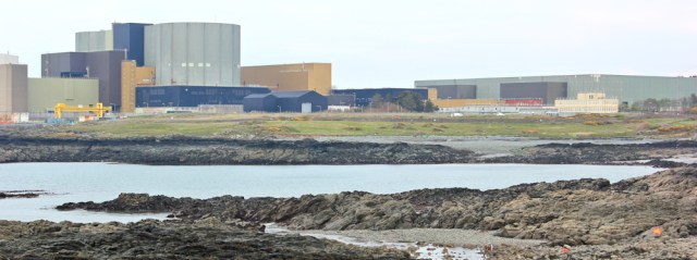
Now the coastal path deviates from the shore, taking a tortuous inland route around the periphery of the power station. The path seems new, with stark fencing and barren landscaping. There are no interesting features to look at.
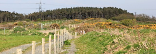
I join a road and, due to some road works, manage to lose the coastal path signs for a few minutes. Luckily I find the route again. It ducks off the road and heads through an area of woodland. This is much more pleasant… although the bright orange tree trunks are a little weird.

Beyond the power station is Wylfa Head, an outcrop of gorse-covered rock, around which the path loops in a circuit. It’s taken me much longer than I anticipated to get here, and the light is fading as the sun begins to sink. I take more photographs of the power station against the pink blush of the sky.
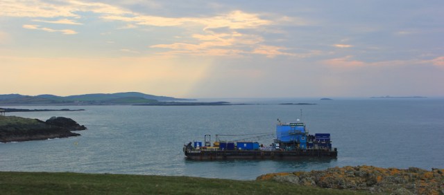
It’s six o’clock now, I’m tired, and I’m very tempted to miss out Wylfa Head. But I know I would regret it if I did. I make my way along a narrow path, stopping to take photographs of a ship moving, slowly, through the water below me. It’s an ugly old tug, but the view behind is dramatic.
Coming round the headland, I’m struck by how the flowers seem to shine in the dim light. The yellow gorse is bold and bright, as usual, but the blue flowers that carpet the grass seem to glow with an inner light too. I’m glad I didn’t miss the headland out. There is something rather magical about this time of the evening.
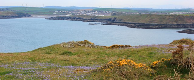
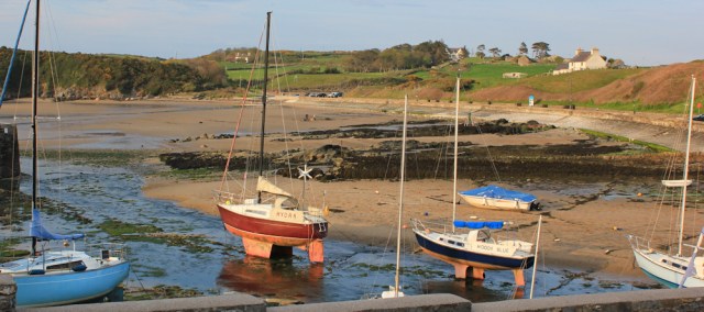
From here the walking is easy, following a wide path along the top of cliffs, towards Cemaes, where I am booked into a hotel for the night.
The tide is out when I reach the bay, but the sun slides out from under the clouds and bathes the harbour in one last wash of golden light. It’s a wonderful end to the day.
As I walk towards my hotel, I remember my little car sitting miles away in Llanfaethlu, and hope it’s safe and waiting for me to return in the morning.
High points: Unexpected beauty of Llyn y Fydlyn and the evening light on Wylfa Head.
Low points: realising I have consistently spelt Cemaes as Caemas!
Miles walked today = 15 miles
Wales Coast Path so far = 937 miles
Total distance around the coast: 2,444 miles
Route:


I remember this walk well. I managed to get a bus to Rhydwyn a little inland from Church Bay and walked down the road from there to Church Bay. A Swiss couple were also on the bus doing the same walk but ending at Cemaes. They were the ones that asked me what Holyhead Mountain was and when I told them said “Pfft that’s not a mountain”! I walked on to Amlwch but to be honest it was too far in a day and I was realy tired when I did finally get there!
I remember that lovely beach too just before the “seasonal” part of the coast path. I’m glad you managed to get around the power station ok (I think it’s disused and being decomissioned)? I tried to follow the coast path signs but must have missed one because the road I had been signed to follow took me right up to the power station. Blundering back into the woodland I managed to locate a Wales Coast Path sign and followed it, only to end up back on the road I had come from. So I followed it back the other way only to come up against a temporary fence over the path. I managed to squeeze past it and read the notice on the other side of the fence that informed me the part of the path I had been on was closed! I think it cost me about an hour in the end! I remember having to follow the pebbles over Cemlyn Bay. A bit hard going, but I was glad I stuck to the coastal route, as it was lovely.
Hope your car was OK. I’ve heard mixed views on the right thing to do in this situation. I’ve heard occasions (mostly in mountain areas) where people have raised the alarm if a car is left in the car park after dark assuming the person may be lost on the mountain (rather than perhaps doing a multi day walk or simply wild camping) and in need of help. I’ve heard it recommend you leave a note on your windscreen saying where you have gone and when you will be back to avoid this. And I’ve heard others advise NOT to do that because it will make your car a target for thieves because they know it will be there for a day or two. I think if it was me I’d just leave it without a note and hope for the best!
The route around the power station was confusing. And those pebbles were tough. But this was a beautiful walk, although I wouldn’t have had the energy to go on to Amlwch – or the time to make it before night fell. I’m such a sloooow walker.
I think you’re right and if you park in an isolated mountain or moorland carpark you ARE supposed to leave some indication of your planned return, to avoid a search and rescue attempt being launched. But you’re also right to worry about attracting thieves. In this case, I simply parked in a normal residential street, which is what I try to do when leaving my car overnight so that it doesn’t stand out.
Were they twitchers – people who glimpse a bird, tick it off their list and move on, or were they birders (as they refer to themselves) who simply enjoy watching birds? Maybe a bit of both!
The juxtaposition of orange tree trunks and a nuclear power station is a little disturbing…
I’m amazed how far it is around Anglesey. I’d always thought I could knock it off in a long weekend. Won’t be trying that, then!
They were probably ‘birders’ Tony! I’m as ignorant about bird-watching as I am about birds 😀
The Anglesey Coast Path is far longer than I expected too. Like you, I thought it might take a couple of days. But it’s 128 miles long. So 1-2 weeks of walking usually.
Familiar conversation on my Welsh boundary walk:
“I’m walking round the Welsh border”
“Where did you start?”
“Fishguard”
“Where will you finish?”
“Fishguard”
“Oh!”
——-
The red trees near the power station worried me also.
Love the anecdote, Conrad. I’d forgotten you’d done a complete circuit of Wales. One day I hope I will go back and complete the Offa’s Dyke walk.
I think I’ve solved the mystery of the orange-red tree trunks. Not radioactivity after all, but an algae. https://en.wikipedia.org/wiki/Trentepohlia_(alga)
That’s a relief (and a bit disappointing tbh!)
Hi Ruth, I forgot to mention that the house surrounded by huge walls (by the “ugly bridge”?) was once owned by Capt. Vivian Hewitt see below
https://www.facebook.com/notes/rhydwyn-church-bay-anglesey-wales/captain-vivian-hewitt-lived-in-cemlyn-he-is-now-a-forgotten-hero-his-fame-lost-i/219676821387783/
Oh what an interesting story! I’d never heard of him but what a brave man and a great achievement. Thank you for providing the link.
Those Welsh place names are hard aren’t they? I love the golden hours at dawn and dusk, it really adds a beautiful glow to everything and makes for stunning photos.
I’m not a morning person, Marie, but I do love evening walks – as long as the sun is shining!
As I’m sure I’ve said before, it’s fascinating reading your walk reports and seeing places through a fresh pair of eyes. Your detour at Cemlyn Bay must have been a pain, but this is such an important site for nesting Terns and unusually well protected. If you’d been there a little later you may well have encountered the birds – they can be very defensive and will dive-bomb interlopers! They make cows look tame!
Nesting terns are responsible for a fair few deviations, I’ve discovered. Agree we need to protect their nesting sites, and don’t mind really. But that shingle was tough.
I think the deviation to avoid Carmel Head in winter is because there a lot of pheasant shooting there.
I love Carmel Head – so remote and quiet. Sorry it wasn’t for you.
PS Realise you’re now near Barrow but have only just got round to reading this. I admire your perseverance – keep going!
Hi Alan, I’m sure on a sunny day, with less wind, and if I hadn’t been so hungry, I’d have loved Carmel Head too. I’ve learnt that my emotional state of mind definitely affects my perception of a place!