
Leaving Flint castle behind, I continue my coastal trek. The path is wide and I realise I’ve joined cycle route number 5, again. I’ve been playing tag with this particular cycle way since Anglesey. But I don’t meet any cyclists, just a few dog walkers.

The wide path soon comes to an end, and the cycle route disappears off to the right, as I enter a boggy area. Thank goodness some wooden walkways have been provided.
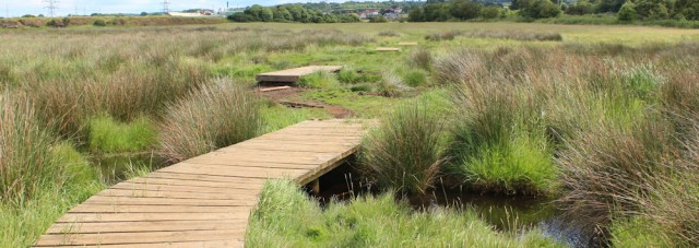
The water in the marsh is a weird colour: an abnormally vivid blue. Indigo? Violet? Doesn’t look natural. And the surface is covered in a layer of scummy particles.

The Wales Coast Path signs seem to fizzle out and I realise I’m on a sheep trail, not a proper path, when it leads me into a thicket of wizened trees and then simply disappears. Never mind. I take the opportunity for a quick toilet stop under the cover of a hawthorn bush because I know the next section of my walk – if I ever find the path again – is through a built-up area.
I’m lost in the marsh! Forced to backtrack, I splash around for a while, until I manage to pick up the path again. It crosses over the railway line and enters a residential area, where I walk down an alleyway between houses. Next minute, I’m back on cycle route number 5, which also happens, sadly, to be the horrible A548.
After the peace of the marshland, the roar of the traffic batters my brain like a pneumatic drill.There’s not much to say about this section of the walk. At least there’s a pavement.

Unfortunately, I have to follow the noisy road for 3-4 miles.

Just when I’m growing anxious because of the lack of coast path signs, I come across these diddly little markers in the tarmac.

Blink and you’d miss them. Still, they’re better than nothing. Just.
I pass a doorway with a heap of sand bags piled up outside. Crikey! Was the weather so bad yesterday? Or are these left over from the winter?
Onwards. I have a period of relative peace when the path curves along a quieter, residential road, running just to the left of the A548, for a short distance.
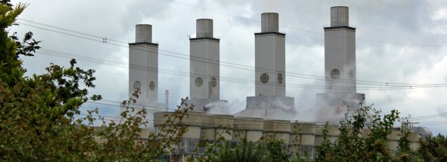
The power station looms above the bushes. I’ve been watching these four chimneys, off and on, for many miles. Now, here I am, walking in their shadow. They’re elegant, I think, like tall sentinels rising out of a mist of their own making.
I rejoin the A548 and come to a very complex roundabout. My mission is to get to the other side, crossing over 2 slip roads as well as the main road, to reach the B5129. There seems to be never-ending streams of traffic. I make it in the end – but I have to run, and that’s not easy in water-logged walking boots!
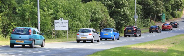
Connah’s Quay is ahead. It’s a nice name, suggesting a pleasant marina and waterside. But the main thing I notice is the traffic along the B5129. It’s 4pm and I guess the beginning of the evening rush hour.
I walk past a school. The pavements are crowded, with coaches lined up along the road. and teachers are shepherding noisy teenagers into queues. It looks chaotic. I have no idea how the right students manage to get on the right bus. And I wonder how many end up in the wrong place entirely?
As I battle through the hordes, I can’t help feeling sorry for the kids. I can remember knowing the name of everybody in my primary school in Africa, and even the larger secondary schools I attended had 300 students at most. I would hate to have been a pupil in a school like this one. It must have over 1,000 students, I think. Why are schools so big nowadays?
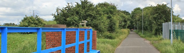
I’m desperate to get off this road and can’t resist a little alley way that leads off to the left and which, according to my Garmin, is a public footpath. The alley zigzags around the back of buildings, and the ground is covered in litter and dog poo. At one point I come across an abandoned mattress. I’m beginning to think I’ve made a bad mistake…

… when the path hops over the railway line and emerges in an unexpected area of greenery, threaded with paths. ‘The Rock’, says a signpost.

After a false turn, when I follow a path down to the water only to discover it’s a dead-end, I find another path and climb up over the top of what I presume is ‘the rock’.
From this high point I have a good view back towards the west. There’s my old foe, the A548, crossing the Dee . Next to it a line of pylons are marching out from the power station. Below me is a patch of vibrant-green marsh.

Onwards. Going downhill now. The path seems to be new and is, I guess, an attempt to improve the aesthetics of the area. A mother is struggling up the slope with a baby in a buggy. A group of school kids with multiple piercings have congregated around a bench and are lighting up cigarettes. They look about 14 years old.
At the bottom of The Rock, I meet up with the proper Wales Coast Path again, and walk through a weird area. Part historic wharf, part industrial park, it doesn’t seem to know what it is. The Dee has narrowed and now seems definitely more like a river than estuary.

At the end of the wharf the path continues through grassland, and I realise I’m back on cycle route number 5. It’s wide and popular. People are walking about – some with children, some with dogs – and I’m overtaken by several cyclists.
Ahead is a bridge. The Hawarden Bridge. It’s the first pedestrian crossing point over the Dee.

The footpath leaves the cycle way for a short detour, running closer to the water.
I walk along the grassy bank and watch a man throw a ball for his dog. He uses a flinger and the ball arcs high and lands in deep mud. ‘Fetch,’ the man says. His dog snuffles around on the dry edge, pretending to look for the ball, but obviously not keen on launching into the bog.
Hawarden Bridge grows larger. The view is slightly marred by the marching pylons.

The sky ahead gets dark. Very dark. I wonder if my luck will hold out because I’ve walked for days in the dry, watching rain clouds dump their water in the distance. Is it my turn to get wet today?

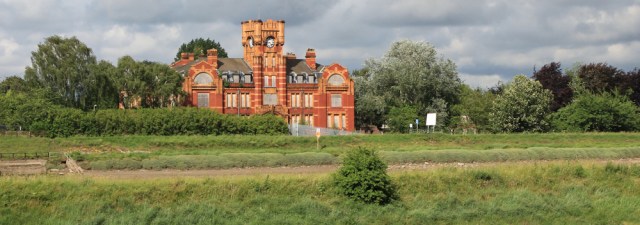
For the moment I’m walking in sunshine, low rays slanting in from the west. On the opposite bank, near the other end of Hawarden Bridge, is an interesting brick building. It looks like a municipal building of some sort, and glows when caught in the sunlight.
I could cross Hawarden Bridge at this point. But my walk is over for the day, and so I turn south, along a long path / cycle route. It’s the sort of route that always makes me feel uneasy when I know I’m walking in a semi-urban area, because I’m hemmed in by a high fence on one side, a thick hedge of bushes on the other. There’s no escape if you meet someone dodgy.

At the end of the path I arrive at a railway station. This is Shotton. How convenient! But unfortunately the train doesn’t stop at Greenfield, and so it’s no good to me. I need to catch the bus.

I walk over the platform bridge, follow the exit signs along another walkway and – to my amazement – find myself on another platform.
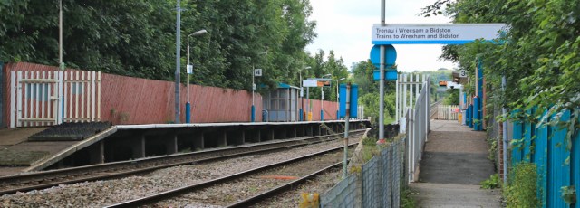
For one moment I think I’ve somehow come full circle, but then I realise that Shotton has two different stations serving two different lines! Greedy.
I leave the 2nd station and head down towards the main street.

The high street is full of Polish food shops. I sit on a bench, where a plump woman wearing a pink track suit joins me. She is busy scrubbing at her scratch cards, and it looks like bad news because she flings them down in disgust.
My bus fare is ridiculously cheap. I’m the only passenger who rides as far as the terminus at Greenfield. The driver asks me where I want dropping off and takes me right back to my car – very kind of him, and a nice end to a rather difficult afternoon.
Miles walked today = 13 miles
Wales Coast Path so far = 1068 miles
Total distance around the coast: 2,575 miles
Route:


The next section up the Wirral looks interesting. I’ve been trying to predict your route, but I’ll have to wait and see. Take care in these dodgy areas, can’t you carry some kind of weapon, the cliché thing is a hatpin? Your boots could do a good job if aimed in the right place.
I’ve been worried about the next section (between Hawarden Bridge and Neston) because no direct footpath is shown on my OS map. But today I discovered something wonderful: they’ve opened a new cycle route across the marsh along the edge of the military zone. https://chester.cyclestreets.net/journey/53635604/#balanced
Sorry Ruth I’ve been meaning to get back to you with few tips on the Wirral, didn’t realise you didn’t know about the board walk across the Marsh, much easier now. I did that section at sunrise in the opposite direction. Got some very arty photos of the pylons against a beautiful dawn Sky.
I haven’t got a google account so couldn’t do the map route thing for you. The Wirral marshes are walkable in some bits but other parts get too bad underfoot so I’ve always made my way inland to the Wirral way and navigated back to the coast whenever possible which does mean a bit of of a zig zag. Further on some areas you can walk at low tide on the shore alternatively on the Wirral Way or rock armour( latter not recommended as bit risky) Let me know where you intend to finish your first Wirral walk .Any areas you unsure of I’ll try and help. Just let me know.
Thank you, Di. That is all helpful advice. I guess, as usual, it’s just a question of try-it-and-see 😀
Whoopee!
The water in the marsh is certainly a very weird and vivid colour – something to do with the power station maybe?
I love the look of the red brick building so I just had to Google it – seems it was the offices of the old Hawarden Bridge steelworks, originally founded in the 1800s by John Summers who was, quite coincidentally, from my home town. The actual steelworks was taken over by Tata Steel in 2007 and the red brick office premises is a listed building.
Ah, so that’s what the building is. Thank you, Eunice.
I wonder if the water was coloured with a dye to trace the flow path?
I know they do this sometimes, although seems an unusual place to bother. This doesn’t sound your usual enjoyable walking, hope it improves!
Hi Pam, and that’s a very good thought. Yes, it could be. I guess lots of water sources end up in the marsh.
I can confirm that Shotton railway station is an absolute nightmare. I live on the north Wales coast and used it to change trains from Abergele on my way to Wrexham. Never again, I ended up catching a bus to complete my journey. Nowhere had I seen it mentioned that the platforms weren’t disabled friendly.
Oh dear, Eileen, yes it would be a nightmare if you have mobility problems. Lots of steps 😣
The section across the marshes starts just after a huge papermill, UPM Shotton. It’s where I started my working life over 28 years ago, and I still visit the mill each week for meetings. There’s so much interesting history on the section around the Wirral, truly fascinating. None more so than Parkgate where the old sea front still exists, even though the sea is now over a mile away from shore due to the salt marshes silting the area.
Oh, wow. Yes, the whole area seems full of interesting things, and I’m looking forward to walking round the Wirral. It’s an area I’ve never been to before.
The people of Parkgate have had an appeal running for many years to ‘bring the sea back to Parkgate’.
A couple of times a year, on a high spring tide, the sea has a go and races across the salt marches at some speed, pushing the winter nesting birds closer to the village. Hundreds of bird watchers gather at Parkgate as the water chases small mammals out of there resting places in the marshes and they run for the shore, producing a feeding frenzy for kestrels, harriers and owls. It’s quite an amazing spectacle.
When you get there, buy yourself an ice cream, sit at the sea front and imagine what it would have been like when there was a beach and port here there. 300 hundred years ago Parkgate was the major port in the area, long before Liverpool sprung up. Handel gave his first performance of the Messiah there before sailing to Ireland.
Ha ha. I’ll do that!
This one does t sound like the best of walks. Urban areas often aren’t unless you live there and know all the secret places and cutways.
That road was very dull and unpleasant. But the walk by the river was nice.
To complete my North Wales coastal walk I too had to endure(definitely not enjoy)the route from Flint to Connah’s Quay and found it the worst walk of the whole route due, as you found, to the majority of it on pavements beside very busy roads. Much as I hate to leave jobs unfinished, I would not have bothered with this stretch had I known in advance how awful it was.
Hi Raymond and well done for completing the Wales Coast Path. Yes, a horrible section 🙁