
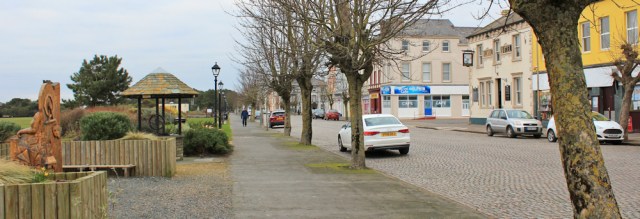
This morning the sun is shining. The fine weather isn’t going to last for long, but I manage to photograph Maryport looking beautiful, with the tide in and the harbour full, and a line of wind turbines gleaming on the horizon.

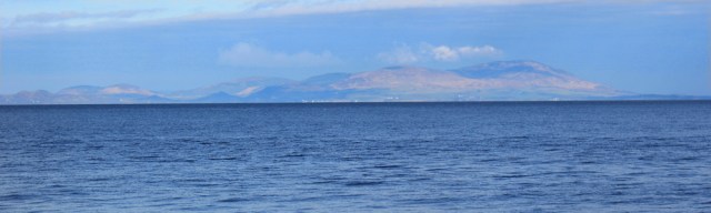
And out across the water, looking to the northwest, is a hump of land. That’s Scotland! So close now. (I’ve actually been worrying about Scotland since I left Wales behind. Can’t believe I’m nearly there.)
But I won’t reach Scotland today. I’m only walking to Silloth. It looks a long way on my map – and I’ll cross over from my OL4 map to my OS 314 one, so two maps are needed.
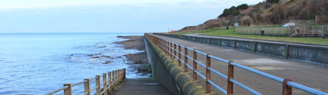
The shore is almost completely covered up by the high tide, so I start off walking along the promenade. It’s a pleasant walk, apart from the constant deposits of doggy poo underfoot.
To my right, a low line of scrubby cliffs run parallel to the shore. In front of the cliffs is a landscaped area, popular with dog walkers.
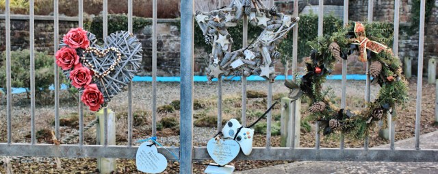
I pass a little park with the obligatory memorial wreaths. These have a distinctly Christmassy feel. The Xbox controller is an unusual touch.
Onwards, and I pass a sad-looking shelter covered in graffiti. Looks like someone is just as fed up with stepping over doggy poo as I am!

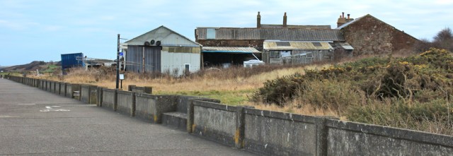
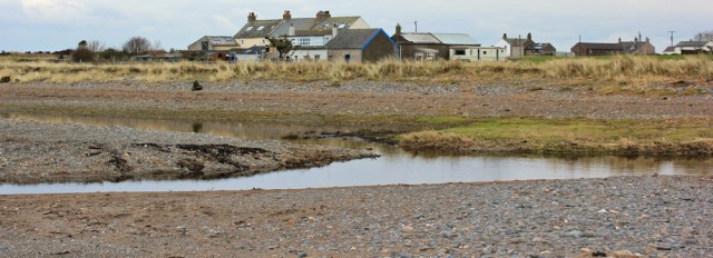
A mile or so north of Maryport and the cliffs come to an end. This place is called, aptly, Bank End. It’s just a collection of houses and tumble-down sheds. I like taking photographs of these types of places too (along with my weird fondness for industrial scenery), but the residents seem to be at home, and so I don’t like to intrude with my camera.
The concrete walkway is about to come to an end, and I see an England Coast Path sign pointing off to the right. (You can see the sign in the photo above.) Going inland? Why? Weird, because my map clearly shows the national trail continues along the shore. Perhaps the path has been washed away?
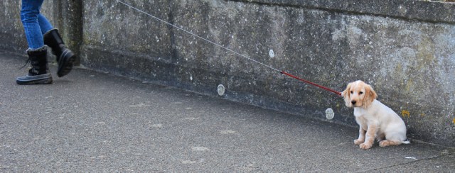
I meet a sweet little puppy. He or she seems very nervous of me, until I introduce myself. Then just wants to lick me to death. I still love dogs, despite being bitten by a crazy collie last month.
I’m still wondering which way to go when I meet a gentleman with three terriers in tow. and ask him if it’s possible to continue along the shore. He says, ‘Yes. You can walk all the way to Silloth if you want to.’ ‘Oh, good,’ I say, ‘because I’m actually going to Silloth.’ He raises his eyebrows and gives me a look up and down. ‘It’s a long way,’ he says.
It’s the second time in two days I’ve been given a warning about my walking plans. Obviously I still don’t look like a proper walker!

A brisk lady overtakes me. She’s the first person I’ve met without a dog, and so I assume she must be a proper walker too. She doesn’t turn off along the England Coast Path, but continues straight on. Good, there must be a way forward. I follow her…
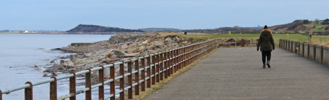
… only to see her turn around at the end of the concrete path and head back the way we’ve just come!
Beyond the walkway is a golf course. But I’m pleased to see a rough path traced along the edge of the links. Onwards.
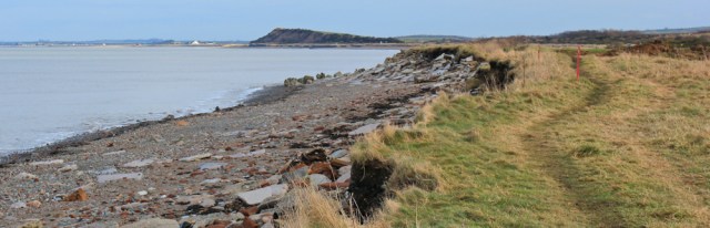
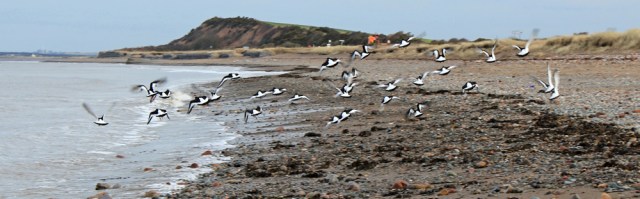
At the end of the golf course I hop down and walk along the shore. Ahead are a group of oyster catchers. I manage to sneak up fairly close…
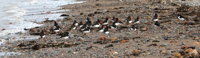
… before they fly away in a brrrrrr of black and white wings. Such odd looking creatures on the ground. So beautiful in flight.
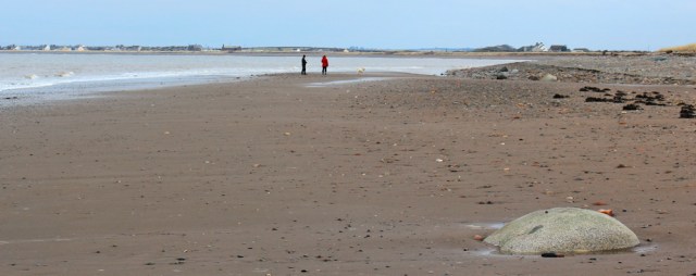
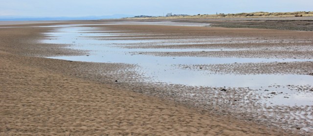
The rest of the walk turns out to be an amazing trek across vast expanses of empty shoreline. It’s not all sandy beach. Pebbles and rocks too. And the occasional stream to wade across. I see very few people – and my heart sings. This is what coastal walking is all about.
I cross an area littered with the remains of smashed up shells. Carried by the waves? Or brought by sea birds? Don’t know.

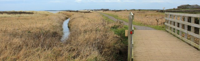
Sometimes I have to head inland to get over some of the larger streams via footbridges. This walkway-cycleway is probably the official England Coast Path. I join it for a short distance.
The walkway runs close to the road. The road signs here are barely readable, old and weathered, and covered in rust. I work out I’m a mile from Allonby.

I walk along the beach again. The sunshine has gone, and I watch the clouds building up over the hills of Scotland.

Passing Allonby now, and I decide not to leave the beach and go into the village. Can just see the houses peaking over the low line of grassy dunes.

I know this short stretch of the England Coast Path ends at Allonby. Only 35km or a measly 22 miles is in place. Will it ever be finished?
[This official map shows how little of the ECP has been completed and how much there is still left to do: PDF of map]
Anyway, I’m pressing onwards and sticking to the beach. Ahead is Dubmill Point.

Near the Point, I see a man picking litter off the shoreline, and stuffing it into a carrier bag. What a wonderful thing to do! I take a photo of him walking back towards Allonby.
Around Dubmill Point, the beach is interrupted by a parade of wooden partitions . Interesting how different areas have different names for the same things. In Norfolk, these structures are marked on the map as ‘groynes’. Here they’re marked as ‘breakwaters’.

Beyond the Point is Mawbray. Again, I don’t head into the village, but I do have to abandon the shore because my path is interrupted by a wide stream.
I turn inland and find a bridge. Here I perch on a tree stump for a quick snack and a short rest. Although I’ve been warm while walking, I quickly cool down when I stop. With the sun gone, and a cold wind, it’s frightening how quickly you can start shivering.
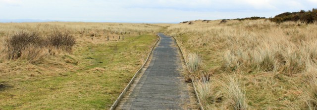
Onwards. There’s a strip of vegetated dunes running along the shore in front of Mawbray, and it all open access land. I follow a wooden walkway through the dunes for a while…
… before heading back to walk along the shore.
In the distance, looking back across Allonby Bay, is the familiar outline of the paper mill, still emitting streams of steam, and nicely silhouetted against the bright sky. I stop to take photographs, and I’m pleased with the results.

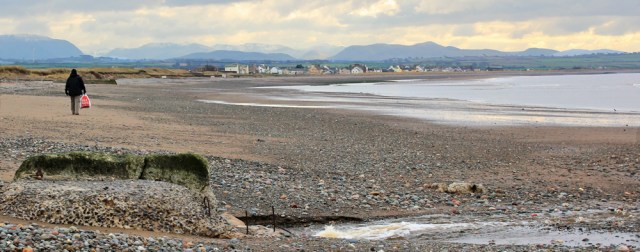
Onwards. The next place I come to is Beckfoot. It’s a tiny place, consisting mainly of a holiday camp. Although I fancy a cup of tea, I don’t go inland to investigate. I expect everything will be closed out of season.

The next stretch of beach is wild and empty. The tide is low now, and I walk out to stroll along the sandbanks, sometimes splashing through pools of sea water. Not a single other human being in sight.
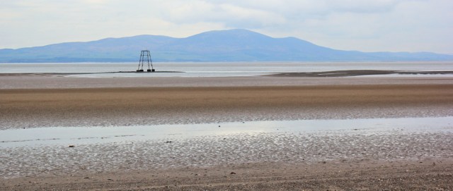
To my left is the constant companion of today’s walk, a hill called Crifell, in Scotland. Very nearly a mountain, but not quite. And I pass the Lees Scar Lighthouse. The top seems to be missing! Is it supposed to look like that? Or has it been damaged by winter storms?
Onwards. I realise I’m getting further away from land, and I head back across the sands and find the shoreline again. The light is fading. I’m approaching Silloth.
I meet a few dog walkers – or rather, I see them in the distance. The sands are hardly crowded!
And then I come to the wall that marks the entrance to Silloth Docks. There’s a strange contraption which I think, at first, is a bell. When I get closer, I realise it’s probably a minimalistic lighthouse.

Time to head inland. I walk over dunes, along the perimeter of an industrial complex.
[Later, I discover the factory I’m walking past is a flour mill, and Silloth has a very apt name. Originally called Sea-lath, meaning the barn by the sea, it’s been an important place for grain farming and related industries since Roman times.]

I’m staying in a hotel in Silloth. It has the usual motley sprawl of holiday parks on its outskirts, but the centre of Silloth is a lovely place with sett paving (not cobbles, thank you for pointing out the difference, Mike Norman!), a wonderful green, a golf course, and fine houses along the main streets.
Today was an excellent day of coastal walking, and I’m grateful for many miles of fine scenery, along with a little bit of winter sunshine – even though it didn’t last very long.
You can read about Silloth and its history: www.sillothonsolway.com
Walked today = 13 miles
Total distance around coast = 2,982.5
Route:


Ha ha – I don’t actually know what the formal difference between setts and cobbles is, other than apparently there is one (as I found out in a pub in Silloth when I remarked on how much I liked the “cobbles”). Scotland looks tantalisingly close but presumably you will have to go almost into Carlisle to get over the river Eden? So near yet so far? A pity this got demolished in the 1930s: http://www.forgottenrelics.co.uk/bridges/gallery/solway.html although if crossing on a Sunday you’d have had to take care not to be trampled underfoot by the good citizens of Annan coming the other way in search of beer on the Sabbath!
And I thought you were the expert, Mike 😀
Had to resort to Wikipedia! ‘a sett is distinct from a cobblestone in that it is quarried or worked to a regular shape, whereas the latter is generally a small, naturally-rounded rock’
Shame the viaduct doesn’t exist any more. I shall have to look out for the remains of the pier when I walk past that part of the coast.
Thanks for the extra info! As for the Solway Viaduct you won’t be able to see any remains other than the embankment jutting out (pointing towards the one on the north bank). I did actually go out to the end of it but in terms of interesting industrial archeology it wasn’t worth it – the top of the bank is very overgrown especially with pretty impenetrable spiky stuff (I still have the scars) and the land along the bottom is just mud/quicksand and marsh, so I had to edge my way along the revetment (another new word I learnt when I was there) but that was quite tortuous (if not dangerous). All in all it took nearly an hour to get out there and back and all I got to see was a small pile of rust. You can see all you need to see from the images on the internet!
Thank you for the warning! I’ll stick to the bank.
Much more about the extraordinary Solway viaduct here https://solwayshorewalker.wordpress.com/2016/07/26/the-solway-viaduct/, on my Solway Shorewalker blog. What a shame it no longer exists!
glad to see still going well. pressing on with my own walk in bits in my own way
What a fabulous set of photos, Simon. Enjoyed looking at them. I’m half-heartedly doing the Thames Path, inbetween coastal expeditions. Walked from Erith to Kew and really enjoyed the urban scenery. Was surprised how rural Putney felt.
Many thanks – will get back to it next month
Look forward to seeing more of your walk photos
Yay, Scotland! Though I can see the challenge of our incredibly indented coastline.
I was taken to Silloth on a Sunday School trip aged about 3 but I don’t remember it. There is photographic evidencehowever! I’ve been to Maryport more recently though even that was a while ago. Maybe time to reinvestigate the Cumbrian coast – those fells are just too enticing!
Some parts of the Cumbrian coast are really lovely (St Bees Head, for example). Others less so. Yes, the fells look very enticing… and I’m trying to stay focused on my coastal walk, but would love to return and climb Black Combe one day.
Now this looks a lovely walk. On my last visit I had to catch the train home which meant either going south to Lancaster or north to Carlisle. I opted for the latter and I was also surprised to see how quickly Scotland came into view (from Nethertown, where I got on). It looks hilly! I like the Oystercatchers too, lovely birds. It is always nice to make a long beach walk it sems the easiest route for much of the coast of Cumbria.
This stretch does not sound like a great advert for the England coast path though. Meandering off inland unncessaraily and on your last walk already closed with a diversion due to erosion (the path was meant to include automatic “rollback” in the event of erosionI thought?). Still now you’ve nearly finished England I guess this doesn’t matter so much.
It was a joy to be able to stick to the beach, Jon. And it seemed so effortless, compared to some of the other walks I’ve done in Cumbria, where I’ve been wading through marshy bogs, trying to find my way along farm tracks, and generally messing about and not getting very far!
I’ve concluded that the main problem with the England Coast Path is the overwhelming desire to be ‘safe’. The diversion north of Workington, for example, was probably entirely unnecessary. I’m sure we’ve walked far more difficult routes on the SWCP and Pembrokeshire.
Hi Ruth, remember that large erratic you passed just outside of Southport, nr Crossens? Well that was Criffel granite. Still a way to go yet and you have to walk around Moricambe Bay.
BTW you don’t need to go all the way into Carilse, the A495 crosses the Eden before you get to to the outskirts of Carisle
Ah, yes Alan. Thank you for reminding me about that rock. Criffel is one of those iconic coastal-walking landmarks I think (a bit like Black Combe, near Barrow). Looking forward to Moricambe Bay. Just hope it doesn’t take as long to get around as good old Morecambe Bay 😀
Excellent read again Ruth. I’ve leant so much from your blog.
Can’t wait for Scotland, it’s a stunning coastline, you’ll be bowled over by the scenery, but not an easy one to navigate is it Ruth?
Hello Di and thank you. I’ve learnt a lot from looking things up after my walks, and from the commentators who kindly post links and information here. Yes. Scotland. Nearly there!
I have been following your blog since you started your coastal walk, way back, and am one of your silent majority of readers. Unfortunately, these days I am unable to arrange any long walks due to home commitments but as I read your down to earth write ups I feel I am walking the route myself, with you in spirit so to speak. Am looking forward to visiting Scotland soon via your column. Thanks
Hi Mike and thank you for taking the time to comment. It’s always nice to hear from a ‘silent’ reader. Very pleased to hear you enjoy reading my blog. I know what you mean about home commitments, and happy to have your virtual company on some of my walks! Best wishes, Ruth
It’s great sitting on the sofa in the warm viewing parts of the country I have barely heard of via your brilliant photographs. You always capture the essence of the places you walk through, warts and all. It looks like parts of this route so far have been hard work!
Thank you Theresa. Yes, the Cumbrian coast has been rather a challenge, due to the lack of a proper coastal path for most of the way. There used to be a Cumbrian Coast Path (still shown on some of the older OS maps) but it has disappeared. And the short route of the new England Coast Path errs on the side of safety-first, rather than taking the most direct coastal route. I enjoy a challenge 😄
I did this walk yesterday, completing the west coast of England as I did so (I’ve not done it in order), though I still have some parts of the west coast of Wales to complete.
I started from Skinburness and did the loop of Grune Point first then after Siloth docks stuck to the beach the entire way. It was long, but a great walk – though I made an error of planning in that I was walking into a strong wind the entire way (should have gone in the other direction), with occasional sand-blasting too. My hair made it look like I’d had an electric shock at the end! The tide goes out a long way here, a but like Weston-super-Mare. I took a look at the map of the England Coast Path and concluded that it mostly was next to the road and since the tide was out the beach seemed a better bet. I think the first time I set foot on it was the promenade at Maryport!
Well done on completing the west coast of England! And what a great walk to finish with. But, yes, tougher with the wind blowing in your face!
What a lovely walk. We have a man here who walks along Weston Shore picking up litter. He’s made himself a strange contraption, a cross between a pram and a bike to carry it all. I think he deserves a medal. The broken shells may well be from sea birds. I’ve watched gulls and crows taking cockles up into the air and dropping them to break them open here.
This looks a lovely walk. Maryport looked so pretty in the morning sun and the oystercatchers looked wonderful in flight. What a thrill it must have been to finally see Scotland!
It seems you managed to find a lot more paths than I did. I stuck to the sand nearly all the way (even when it turned into silty mud 😕) as every time I tried to check out whether there was an easier path it came to nothing! Oh well.
I really liked Silloth too, it’s a lovely town – probably the nicest on the Cumbrian coast.
Oh, and I called them cobbles too!
Amazing stops at Allonby …. twentymans ice cream shop
And The Codfather fish and chip
Shop
Thank you so much for
All
Your guidance Ruth
You helped
Us so much as we
Have nearly
Finished the Cumbrian coast
Just 7 miles near Ulverston yes
We sing your praises every time
We just have those 7 miles
Then 70ish miles of the NY moors coast left to finish our walk around England
We could not have done it without your
Guide
Thank you