
There is no footpath marked on my map, but I found a description online for a walk along the coast from Ganavan Bay northwards, and I jotted down the instructions on my OS map.
First, I must go “through bushes at the far end of beach” and then through a kissing gate. So far, so good, and the path looks pretty clear.

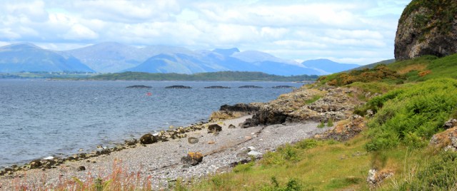
Now I can walk along the shore, and admire the view across the water. Those mountains over there look really high.
“Follow path until clear gap in cliffs on right.” Think this is the spot. Here I must head inland up a steep slope… hmmm, there’s a faint path up the hill… yes, this must be it.
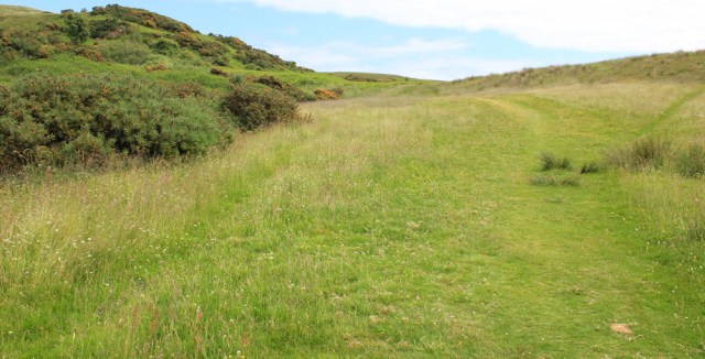
At the top of the slope, I turn left to follow the top of the cliffs, and climb over Ganavan Hill. The views are wonderful. And I needn’t have worried about losing the footpath because there are plenty to choose from.
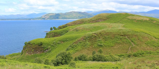
After a mile of pleasant walking, with plenty of up-and-downs, I begin to come down off the high ground. Coming up towards me is a straggly group of walkers. What a surprise!

It’s a long time since I’ve met a serious walker on the coast path. (In fact, I think this is the first group I’ve met since the DoE students on the beach by the Turnberry golf course.) The leader waits on the slope for the rest of the group to catch up, and we have a brief chat. She’s not Scottish. Sound Danish, or Dutch.
I stop on the slope to let the rest of the walkers come past me. Some are struggling with the steep slope, and I’m reminded how fit I’ve become after several weeks of almost constant walking.
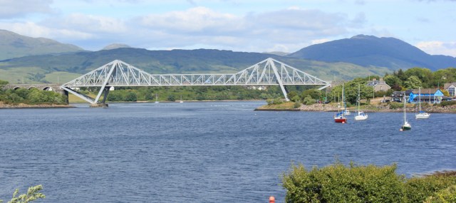
Now I’m looking down on a village called Dunbeg. It seems larger than my map indicates, with a collection of bright new buildings. Beyond Dunbeg is a marina, and then a flat spit of land, and then… ah, there’s a bridge. That must be Connel Bridge, and it will be my final destination today.

I follow a footpath down to the shore, and end up above a pretty little beach. Can’t work out if those blocky new buildings are an industrial complex or a leisure complex.

I scramble down the slope to walk along the sand. It’s a very pretty bay. One of those gorgeous horseshoe curves.

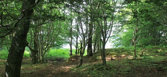
On the other side of the bay, I walk through a group of trees. Love coastal woodlands.
And then try to follow the shore around the headland. It’s hard work. There are plenty of footpaths, but plenty of obstructions too. In fact, the headland consists of a series of pretty little coves separated by rocky outcrops.

I reach the point (Rubha Garbh, says my map), where a narrow channel separates the mainland from a small island (Eilean Mor). A little boat chugs through the gap.

During my trek around the headland, and to my right, I’ve been vaguely following the line of an old stone wall. Now, as I continue round, I discover the structure the old wall belongs to… Dunstaffnage Castle.

I would have gone into the castle for a few minutes, but it looks like you have to pay, and it seems barely worth it for a very brief visit. Also, I need to save some money for the bus back to Oban.
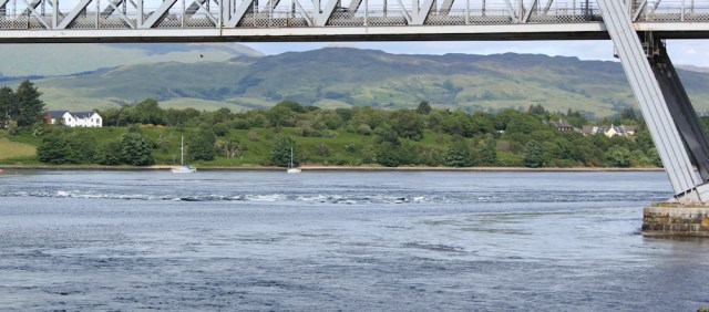
Now I’m walking along a path around the shore of Dunstaffnage Bay. I stop for a brief rest and a drink, and to admire the view across the bay.

While I’m resting, I scroll across the map on my Garmin, and work out that the high mountain (just right of centre, in the photo above) is Glencoe. Or, at least, I think it is Glencoe.
I reach the road. It’s not a very impressive entrance to the castle, I must say.

I walk past the blocky new buildings I saw earlier, and realise they’re part of a marine science park. SAMS – Scottish Association for Marine Science and, nearby, is the European Centre for Marine Biotechnology. All very new looking.
They’re widening the access road to the science park. Or, maybe, creating a walking/cycle path. I’m not sure.

While walking along here, a car pulls up and a couple of tourists (German, I think) ask me if this is the right way to Dunstaffnage Castle. Yes, I tell them, it’s straight ahead. I’m not surprised they are a bit confused. The castle is in danger of disappearing behind all the new buildings.
I reach the residential area of Dunbeg, where the houses have an older and shabbier look to them.

I reach the main A85. Unfortunately, I have no choice but to follow this road into Connel. It’s not very busy, but carries a constant stream of very fast traffic. Thank goodness there is a pavement… until I reach the entrance to the marina, and the pavement disappears. Oh dear!
The next mile is easily one of the worst pieces of road-walking I’ve been forced to do. I stumble along the verge, buffeted by the slip streams from cars and lorries, and cursing the road builders for not providing a proper pavement for pedestrians.
Luckily there are some great views to help ease the pain of this awful road. And there’s the bridge I’m heading for – Connel Bridge.

I pass a homemade sign for Oban Airport. Oban has an airport?

The next turning is “Old Shore Road”, and I assume it’s the access road for the airport. I check my map and realise this quiet lane will take me off the main road for a short while. That’s excellent. Ok, I’m heading for the airport.

The lane curves around by the shore, passing through a quiet residential area, where people are tending their gardens, mowing their lawns, and washing their cars. No sign of the airport, but a truly excellent view of the bridge.
A roadside sign warns “Caution. Cats. Dogs. Ducks.”
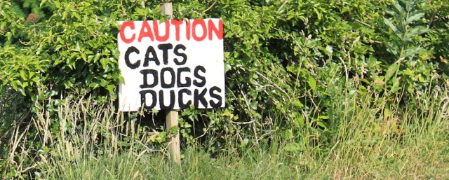
Ducks? Ah yes, here’s a drake in the middle of the road.

Still no sign of the airport. I follow my lovely lane as it curves back and rejoins the main road. But at least from here onwards there is a pavement to walk along.
I’m approaching Connel and the traffic hots up. This is where the road branches off to Fort William, and ahead is the bridge.

I can’t quite work out how to get onto the bridge, which crosses over and above the main road. Maybe I need to go up into the village? But I’m tired and decide to leave that adventure until tomorrow. Instead, I stop in a little park area, and read an information sign about the Falls of Lora.

The mouth of the loch is dead ahead and, apparently, “At certain states of the tide you will see spectacular overfalls with a water level drop of up to 1.2m and a lot of white water in front of you.”

I peer out across the water. Under the bridge there does seem to be a ripple of white water. Is that it? Is that the Falls of Lora? Well, they’re not very impressive.
Time to head back to the road and wait for the bus. The first one to Oban seems to come from the wrong direction, and takes me by surprise. I don’t get my hand out in time, and mutter rude words as the bus hurtles past.
I must wait half an hour, before I manage to catch the next one.
High point today = the lovely path from Ganavan Bay
Low point today = horrible road-walking along the awful A85
Miles walked today = 11.5 miles
Total around coast = 3,872 miles
Route: Black in the morning, red in the afternoon.


Hi Ruth
Just to say I completed the Real Lancashire Boundary at the end of July.
I walked 432 miles in 30 days in June and July.
Not sure when you walked the Lancashire section of the coast. Perhaps you can point me to the sections on your blog.
Must say I enjoyed every minute except when Ivead layed up with a bad back.
All the best.
Hi Philip, and well done for completing the boundary walk. I was in Lancashire 2 years ago, and you can find the first walk where I crossed the border here: https://coastalwalker.co.uk/2016/08/31/tarleton-to-preston/ with the rest following in sequence. Hope your back is better now. Back pain is such a nuisance. Best wishes
Hi Ruth I did Portchester Castle (Near Portsmouth) to Winchester Castle last Saturday about 24 miles in 10 hours. I thought of your inspiration.
Hi Baz, and that’s a pretty impressive walk. Happy to have inspired you 😄
Hi Ruth,
Nice to here your on your way again. Just to let you know ‘you have past’ me as I will be starting from Craobh Haven again in a couple weeks time. Reason you have past me – I walked to the Mull of Kintyre then north over the moorland, walked around Gigha, did one long walk on Islay, walked the eastern coast of Jura, walked and cycled around Colonsay, walked around Taynish and Keills peninsula, walked around all of the Craignish peninsula + having time off for a few weeks on grandparent duties. So – I will now be checking your routes to help me decide how much ‘off piste’ walking to do so I loved todays post. Great to see you past some other walkers today as I think the Scottish Access rules don’t work in practice. Its only the very confident walkers who go on really off road sections which prevents general walkers enjoying the Scottish coast. It’s not perfect in England but you can follow the green lines on a map with young or older family and if you come to a river or a field boundary there will be a bridge or a style in most cases – I get sick of crossing barbed wire fences for the sake of a simple still. A woman farmer had put in 2 wooden stiles on the west coast north of Craignish but she never sees any walkers and I understand why. Use your access rights in Scotland and your on your own and you never meet anybody for that reason. Its great when you find a bit of waymarked path ie Kintyre Way but look at any Scottish map and tell me where it is safe to walk. I only walk with my wife when I know the conditions are going to be pretty good – I do all the hard bits myself.
Last comment – I have past and walked through many herds of cows this year and been followed and snorted at several times but as long as I have got my walking stick or golfing brolly I can face them off and very rarely give them a wide bearth – but thats me – I always look for a way out though just in case!
Hope you get some nice weather for the rest of your walking this year.
Ian
Hi Ian, and well done on your very impressive walking! You must have had an amazing time walking round those islands, No wonder I’ve “overtaken” you 😆
I must confess I feel a little guilty about missing out so much of the true coastline. But, as you point out, walking the coast in the absence of footpaths is really difficult. “Right to roam” is great in principle, but I do yearn for those dotted green lines on th OS map!
Glad you’re managing to keep the cows at bay
Nice to read a further post. I was beginning to wonder what happened to the afternoon of this walk. I guess you had a very long lunch break! Still a half-hourly bus that far north in Scotland is a luxury you don’t often find!
Yes, a very long lunch break! And I was lucky with the buses. 😄
Sorry Ruth, you are a long way out in thinking that the ‘pointy’ peak is in Glencoe. It is, in fact, Ben Cruachan.
The Falls of Lora I think are best viewed from above the Connel Bridge and with a big tide range.
Oooh, completely lost with my landmarks, as usual 😄 Thank you for the accurate information! Yes, the Falls of Lora were certainly worth a revisit. Must write up the next post.
Love the header photo and the ‘cats dogs ducks’ sign, and I think the coloured houses in the bottom right of your photo overlooking Dunbeg village look rather Scandinavian 🙂
Yes, they do look Scandinavian, don’t they. A lot of new building in this area of Scotland,
Wonderful views from Ganavan Hill. I hope that bridge had a path for pedestrians. The engineers that plan and build our roads should make provision for walkers!