
The bus takes a confusing route into Connel. Convinced we’re about to bypass the town altogether, I panic – and get off several stops too early, so I must walk nearly a mile to reach the place where I ended my last walk.
Despite the dismal weather, the Falls of Lora look impressive today. Yes, there’s definitely lots of white water flowing under the bridge.

I do love bridges, but have to admit that the Connel Bridge isn’t exactly beautiful. Why such a long, flat, central span? And, bizarrely, the bridge only carries a single-track road, which means that traffic has to queue with traffic-lights at either end. Why so narrow?
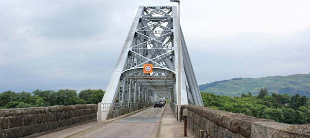
The pavements are narrow too, and the whole structure shakes under the wheels of heavy vans and lorries, so the crossing is rather nerve wracking. But one of the advantages of the traffic-light system is the blessed gaps in the traffic.
I linger in the centre of the bridge and take plenty of photographs.
Yes, the Falls of Lora are impressive. It really does look as though there is a waterfall in the middle of the sea loch. Well, maybe not exactly a waterfall – but definitely a stretch of rapids.

During a gap in the traffic, I cross the road and look over the other side of the bridge. The water towards the sea is calm and flat. Far more peaceful over here.

I walk back over to the other side of the bridge, and stare at the falls for a while. A ridge of rocks causes the white water to form, but there is a strong impression of differing water levels.
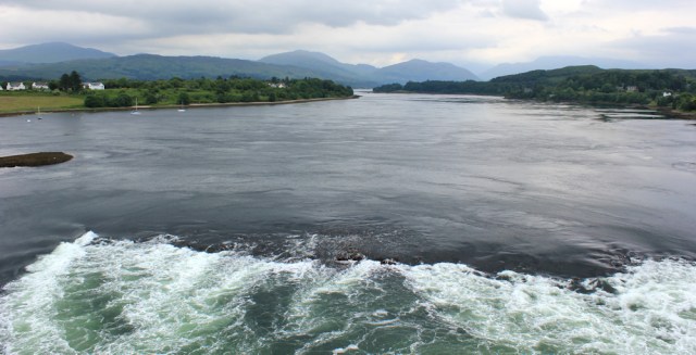
Must be even more dramatic during the high tides of spring or autumn, or after a storm surge. Perhaps I’ll come back one day… perhaps.
Onwards. Safely over the bridge, I take the first turning left off the main road, and walk through a residential area of North Connel.

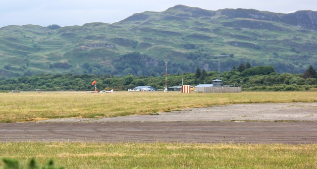
At the end of the road, I’m hoping to pick up a footpath… ah, yes, there it is. And, through a gate I spot what looks like a runway. Ah, finally, I’ve found Oban airport.

The path follows the perimeter fence around the edge of the airport. Signs on another gate tell me to clean up after my dog. And, apparently, litter-lout fishermen are spoiling this area of the coast too.

(Ironically, I have to carefully step over a pile of dog poo in order to take the above photo. It was deposited on the path, less than two feet away from a bin!)
I’m walking through a narrow alleyway of gorse bushes. To my left is the shore. To my right is the airport.

I find a gap in the bushes, and stop to take some photographs. So, that’s the airport? Well, I’m not sure if it really is an airport. More like an airfield. It’s tiny.
The path swings around, and now I’m walking along the shore of Ardmucknish Bay. I meet a couple of dog walkers, but otherwise have the place to myself. It’s great to be back by the coast again.

A buzzing noise makes me look around. A helicopter is arriving at the airport. There is no other sign of activity.

Onwards.
Sometimes I walk along the beach, but the shingle makes a difficult walking surface, and so I keep returning to the footpath.
At the far end of the bay is a caravan park. I had half-contemplated staying here tonight, in The Beast, before my journey home tomorrow. But I’ve already had two nights in a campsite, and I think it’s time for some more wild camping. (I’m worried I might grow soft if I spend every night on a site!)

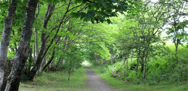
On the other side of the park, I pick up a cycle/walking route. It takes me away from the shore, but it’s very pleasant among the trees.
The cycle path briefly joins the main road, before branching off again. None of these cycle routes were shown on my map, so I’m surprised to find them, but pleased too. Great to be away from the traffic.

It begins to rain. Hard. I stop and quickly stow my camera away, wrap my phone in plastic, pull on waterproofs, and cover my rucksack. The weather has been very kind recently, and I’d forgotten how horrible it is to walk in the rain.
The village of Benderloch is just to my right, and here I reach a junction in the cycle route. The rain has eased slightly, and I risk pulling out my camera and taking a quick photo. My plan was to turn left at this point, and follow a series of paths and minor roads, making a loop around the next peninsula, before returning to Benderloch…

… but, the afternoon forecast is for heavy rain. I can see the car park in Benderloch, just through the trees, and there’s The Beast waiting for me.
The temptation to stay dry and go home becomes just too strong. I’ve been walking for 5 days, and away from home for 5 nights. It’s been my first time in a camper van and it’s been fun. Why ruin the last day by getting thoroughly soaked?
I have a brief, internal argument with myself, and then head towards The Beast. Hello, faithful friend, it’s time to go home.
Footnotes: Later, I learnt why the Connel Bridge has such a long central span. This was in order to avoid having to place supporting piers in the strong tidal current that flows out of the Loch of Etive.
I also learnt that the bridge is narrow because, when it was opened in 1903, it was originally a railway bridge.
Miles walked today = 4
Total distance around coast = 3,876 miles
Route:


AH a railway bridge, that explains it. I did wonder if it was a temporary bridge (perhaps constructed after damage during World War II), which had become permenant but obviously not.
I also didn’t realise Oban had an airport but I see there are flights from there to a number of the islands. Probably a bit like Lands End airport I used to go to the Isles of Scilly which was little more than a field with some portcabins in the corner (though it has been upgraded since).
You should see the airport in Barra! It’s a beach.
Ah yes I’ve head about that. I plan to take a flight there at some point to experience that! I’ve seen it on the TV (I think it was on the BBC Coast) as they have to go to quite an effort for each flight to make sure the beach is free of any debris washed up etc.
It’s well worth it! We’ve done it a couple of times, but not on this latest trip.
Not only was it originally a railway bridge, but for a period of time it was jointly a railway bridge and a road bridge, but it was so narrow that road and rail traffic could not operate at the same time so it was effectively run as a very long thin level crossing with road traffic only allowed on it when there were no trains. I suppose beauty is in the eye of the beholder but I quite like the bridge, particularly in its setting in the landscape. To me its geometry makes it look like a work of modern art – all those triangles!
Interesting. Yes, the bridge has a functional beauty, I suppose. I do like a nice arch, though 😄
I love the photo taken from the bridge with those few house in the foreground, it looks really pretty there. I’m afraid I don’t understand the concept of the Falls of Lora – if the rock formation which causes this is under the water surely they would be more visible on a low tide when the rocks would be more prominent? I may be wrong but that’s my logic anyway 🙂 And don’t get me started on irresponsible anglers who leave their rubbish and used tackle lying around!! 😦
Hi Eunice. There’s a lot of water in the loch, and it can only squeeze out through that narrow gap under the bridge, so when the tide goes out you can get a temporary difference in water level inside the Loch compared to the sea. When I was there, I could definitely see a few feet difference in level. The rocks break up the surface of the water, causing it to look like a waterfall. It was quite impressive.
Hi Ruth – re the falls of Lora – if you had gone into the pub beside the bridge you would have learnt all about the falls of Lora. The best place to see the falls is actually underwater whilst doing what is called ‘drift’ diving. It is not to be attempted by inexperienced divers. Most of the waterfall is actually under water. I may be mistaken but I think it is the only underwater waterfall in the world. I believe divers can be taken down by them to a depth of 30 metres when the differential between the loch and sea is greatest. All the best Chris
Wow. That would be quite a sight. I’m trying to imagine it. Almost make me want to take up diving.
Very good description of a lovely area. With regards to the Bridge at the Falls of Lora, if you look at the National Library of Scotland website they have every old series map and you can see that originally there was only a ferry. When a Bridge was built it was a Road and Rail Bridge with a central pier. I believe it was the progressive erosion of this Bridge pier that led to the decision with the closure of the branch line to make it a roadway only and when finally a new Bridge was required it was a minimum width build but with a long span to avoid teh erosion and keep the cost low.
https://maps.nls.uk/geo/explore/#zoom=15&lat=56.4580&lon=-5.4050&layers=164&b=1
Hi Adam, and thank you for the additional info about the bridge.
The ‘falls’ look pretty and are interesting however it happens. Careless anglers are everywhere – down here several dogs have been injured after getting a fish hook in their paw and one needed a serious operation after swallowing a hook that had been left in a fish head which was just tossed aside on the beach.