
[This walk took place on the 25th June 2018]
I pack up the Beast and leave my friendly campsite behind. I drive northwards to park at the end of today’s planned walk – near the Corran Ferry – and catch a bus back to Kentallen to start my walk.
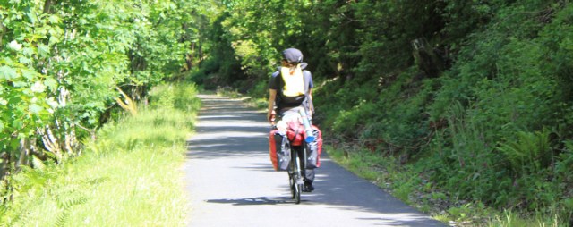
I’m soon hiking along the Caledonia Way cycle way. Cycle tracks are often quite boring for walking, but at least I make rapid progress. The A828 is below me and to my left, while the sea is mostly out of view on the other side of the road. I’m passed by the occasional lycra-clad speeder, and then by this more sedate woman on a touring bike.
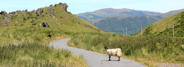
The Caledonia Way passes through woodland, and then across an area of open grazing. Hello sheep!
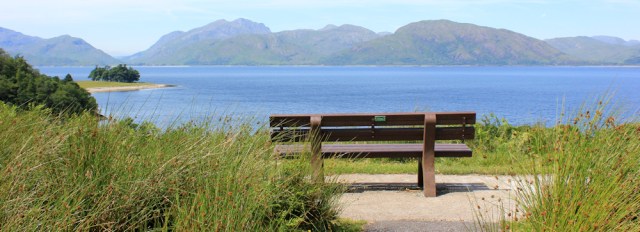
I come to a bench with a wonderful view across Loch Linnhe. One day, soon, I’ll be walking along the far shore. It looks very isolated and wild over there. Will I be able to cope? (I’m already worrying about the section near the giant quarry at Glensanda.)
I’ve only been walking for 10 minutes, but it was a late start and I decide it’s time for lunch. And time for a self-portrait.

A nearby information plaque tells me how Loch Linnhe was formed in a gigantic fault caused by the collision of two continents. Basically, the land that lies on the other side of this Loch is really part of Canada.
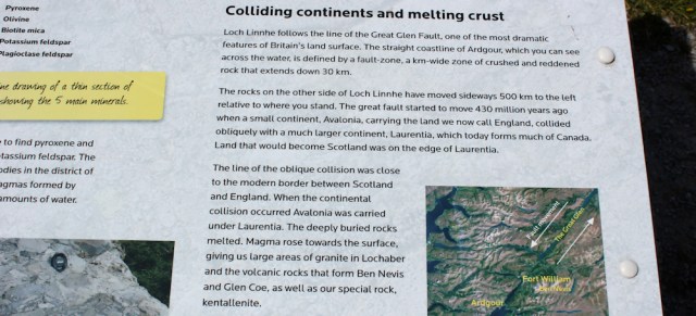
As usual when I read about the tremendous forces that created our present landscape, I’m humbled by my own insignificance. Geological time is so vast, my life so short…
Come on. Enough musing. Onwards!

All too soon, the Caledonia Way decants onto the A828. Oh dear. Am I going to have to walk along this road again?
Luckily, the answer is “no”, as the cycle route continues on the other side of the road.

This is better. Now I’m finally walking close to the water. And here I find a sequence of carved rocks…
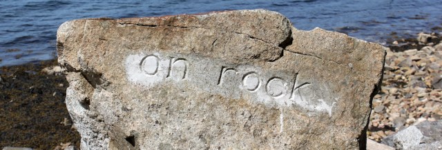
…each one engraved with a few words. A poem?

A wooden board at the end brings it all together, spelling out the short poem in English and in Gaelic. What a splendid place for a poet to leave his or her mark.
“On rock, lichen circles, thrift quivers, birch grows, waters rush, a mooring.”

This section of the walk is wonderful. The cycle track is well maintained, and I walk close to the water of the Loch, surrounded by greenery and wild flowers.

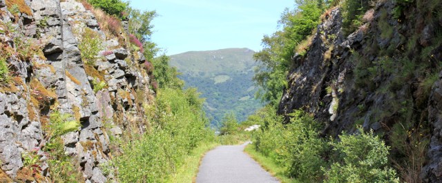
Sometimes the path passes through deep cuttings in the rock, the walls dripping with ferns and mosses. Surely these cuttings weren’t created especially for cyclists along the Caledonia Way? No, I guess this was once an old railway track.
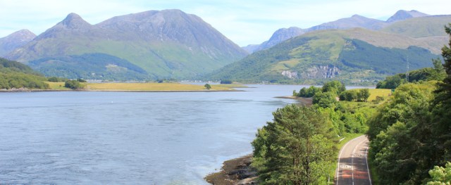
Down by the water again, the path swings round the curve of the shore, and is now heading due east. Ah, I can see the bridge ahead which crosses the mouth of this next estuary. What’s the tall mountain behind?

I don’t have an OS map for the next section of my walk, and I’m about to go “off piste”. This always makes me feel a little nervous, even slightly dizzy, although I know I can rely on my trusty Garmin to find the way.
According to my Garmin, I’m looking up Loch Leven, and the tall mountain ahead is the Pap of Glencoe (I think). Glencoe! I’ve heard about this area because some of my braver friends come to ski in Glencoe and slither about on its icy ski slopes. Didn’t realise I was so close.
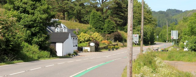
My cycle path leaves the shore, and takes me through the outskirts of South Ballachulish.

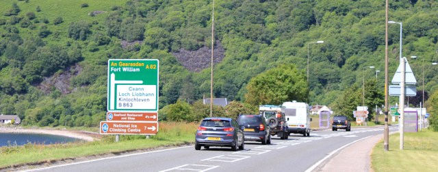
And then takes me downhill and onto another major road. This is the A82, and one of the main roads leading up to Fort William.

I follow the A82 towards Fort William, climb a slope, and cross over the mouth of Loch Leven via the bridge.
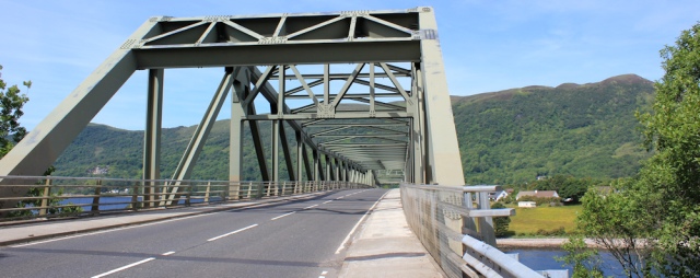
The views from the bridge are magnificent. Loch Leven is beautiful and those mountains look stunning.
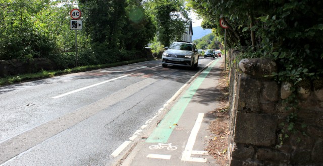
After the bridge, I’m sorry to say, the walk becomes far less scenic. Well, the scenery is – I suppose – rather pretty. But the cycle route turns into nothing more than a wide pavement running right next to the traffic. Rather unpleasant.
I put my head down and trudge along. There are a number of bed and breakfast places here, but they all have signs saying “no accommodation”. Yes, Scotland is actually full!
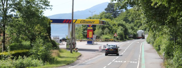
I make a mental note of this garage ahead, because I probably need to feed The Beast, and petrol stations round here are rather infrequent.
The pavement is frightening narrow for both bicycles and pedestrians to navigate.
Here’s a village hall. Looks like a shack, but its corrugated walls are painted a pretty green and there are flowering pots outside.

A road sign tells me I’ve reached village called Onich. Uh, oh. The pavement/cycle path has just got narrower. The markings suggest two-way cycle traffic is possible – which is rather optimistic in my opinion.
A trio of cyclists wobble past me. I don’t take any photos of them, because I’m too busy trying not to step into the road. Never mind, there’s a café ahead, and I’m looking forward to sitting down and enjoying a cold drink.
Oh dear. The café is closed on a Monday. What a disappointment.
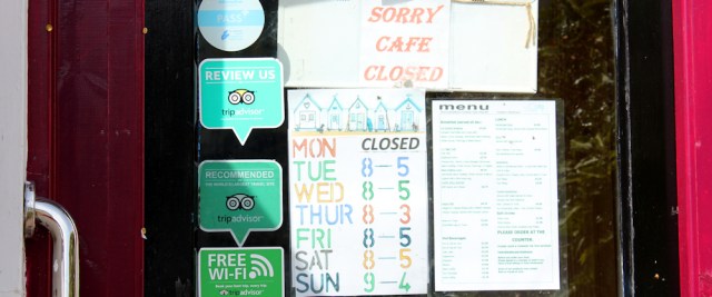
I sit on a bench outside the closed café, and finish my snacks. I’m nearly at the end of my walk, and I must confess I ‘m finding this final section hard going.
I round a corner, as the road curves away from the sea, and the pavement widens again. This is nicer. Much nicer.
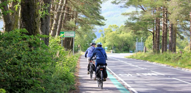
I meet a couple of touring cyclists, with laden saddlebags. At least there is room for us to pass each other.

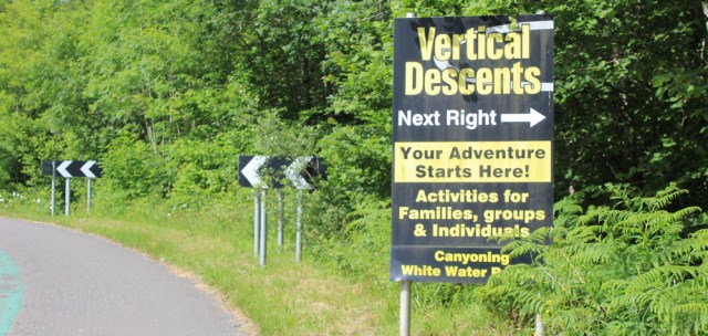
A sign invites me to try vertical descents. Apparently my adventure starts right here. No, thank you. I’ll stick to the road and keep walking. This is challenge enough for me.
Onwards, and this last mile seems to last forever. Why is the last mile of any walk always the longest?

More cyclists overtake me. I must be nearly there now.
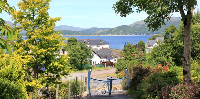
I round another corner, and a sign tells me the Corran ferry is just ahead. Oh, and thank heavens, there is my wonderful Beast, waiting patiently for me.
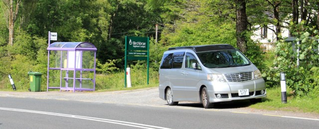
I’ve parked next to the bus stop. It’s not the best place to park, and I was a little concerned that I might get an angry note on my windscreen or, even worse, pick up a few grazes from passing lorries.
No need to worry. The Beast is fine.
I drive back to the lovely beach at Cuil Bay, the one I walked past yesterday. I’m not the only camper van parking here tonight. There’s a lady with a barking dog on one side of me, and a man playing loud rock music on the other. Oh dear. I thought this would be a peaceful spot…
A couple of hours later, the dog has calmed and the loud rock music has been replaced by snores. By the time the sun goes down, all is quiet. I watch the sun set behind the mountains and think how lucky I am to be in this beautiful place.
Miles walked today = 9 miles
Total distance around coast so far = 3,927 miles
Route:


I just finished reading your last post two minutes ago, and another one pops into my inbox! I love reading your wonderful posts Ruth, it feels almost like being there.
Thank you Paul. I’m blushing 😊
I’ve missed your posts Ruth. Glad you are posting again. You ll probably be on the trail again soon! Good luck.
Thank you. Heading back to Scotland this week, hope the weather is reasonable.
Wonderful Ruth! All familiar holiday territory for me and just looking at those beautiful pictures is a tonic for the soul. Love the highlands and what amazing weather you had. I was there at the same time if that was June last year, it was amazing weather. Look forward to more.
Wasn’t it a wonderful summer last year, Di. And what a coincidence we were in the same area!
Hi Ruth, the view up Loch Leven shows three mountains Garbh Bheinn,(left) Sgurr na Ciche / Pap of Glencoe (the conical hill in centre) and Sgorr nam Fiannaidh, a Munro. The Pap is actually the lowest of these hills, but does draw the eye.
Hmmm, the parking place was a wee bit naughty, especially for those emerging from the Birchbrae Lodges onto the A82.
Shame you had to miss out walking around Loch Linnhe and Locheil through Fort William, but the 9 miles along the A82 is not for the feint-hearted. lol.
Thank you for the info about the mountains Alan. Yes, the Pap is dramatic! I did end up visiting Fort William, but not along the A82. Horrible road.
I walked on the A82 into Fort William and around Loch Eil when I did this stretch. It was by far the most dangerous bit of road I walked anywhere. On balance I think what Ruth has done is sensible. Even the cycle route to Fort William crosses Loch Linnhe on the ferry and goes up the west shore, I just did not want to walk the same stretch twice once in each direction. Sadly a number of cyclists have been killed on the A82 south of Fort William recently. Hopefully one day the Council will improve things. Further south there is a cantilevered path beside the M8 near Glasgow just near the Erskine Bridge around the edge of the Firth of Clyde and they could do something similar south of Fort William, but it would be pricey.
Ah, the A82 – it runs past the end of our road. If you had just headed south you’d eventually have come to my house in Glasgow! I must remember that path from Kentallon to S Ballachulish as we’ll be up there later in the year. Looks gorgeous.
It was a lovely walk up to Ballachulish. I’m now very familiar with the A82 roaf to Glasgow, as it’s been my main route into the highlands for the next stages of my walk.
The A82 is very familiar for me too as it’s the route to my sister’s at Kishorn; a long trip from Devon! I wonder if you have in fact reached as far north as that yet? Scotland in good spring weather is just fabulous. Hope the weather is good for your trip up this week.
I’m not sure where Kishorn is 😄 so I guess I haven’t got there yet! Weather has been wonderful, so far. Can’t say the same for the Internet connection- but you can’t have everything!
No internet! Can be a blessing – at times. Kishorn is about 100 mile north of Fort William by that is by road – presumably a lot further as the coastal walker walks.
Happy walking
I love the lilac coloured bus shelter 🙂 Glad you didn’t get any angry notes on your windscreen for parking at the bus stop!
It is an interesting colour for a bus stop, isn’t it. Annoyingly, I discovered there was a public car park just by the ferry. I couldn’t find when I needed it because it was hidden by cars queuing for the ferry.
Welcome back, Ruth. I really enjoy your posts. I have done most of the coast from London to Dartmouth, so peanuts compared to what you have achieved. And I have been at it for many years! I did some gap filling around Pagham Harbour today. Gorgeous! And for the first time, recently, I met a fellow coastal walker. Most exciting! Looking forward to reading your next posts. Hugely impressed by your Highland Adventure…
Hi Kate, and thank you for your kind words. London to Dartmouth is a pretty good stretch, so don’t underplay your own achievement! Glad you enjoyed Pagham harbour. I wonder which coastal walker you met?
Hi Ruth. I am afraid I have no idea. We didn’t swap names, we compared maps…
Welcome back, so to speak. Lovely to be able to read further instalments of your amazing journey. I have always been in awe of the miles you cover, and how you sort out the logistics of this endeavour, particularly when you are on your own.
Knowing I will never walk as far as you, I wondered if I could get around the coast, in stages, in my campervan. Just back from the first short trip, which did not go quite according to plan, I am now even more impressed 🙂 It’s a tricky enough undertaking in a vehicle, what you and the other coastal walkers are doing is hugely impressive. 👏 👏
Hi Jayne, and I think going round the coast in your camper van is an excellent idea. A great adventure. Don’t let one or two hiccups upset your plans, and just keep going!
I too find the geographical forces incredible. As you say, it makes our time on this earth seem very insignificant.
Another lovely walk though I wish that some of the road sections weren’t as hair-raisingly dangerous for you. The views of the mountains are beautiful.
I did part of this walk today as I stayed last night in Fort William before heading home. It was too nice to just go straight home so I decided the closest bit of coast I’m planning to walk near Fort William is from Corran Ferry (I think I will cross there). So I was pleased to find on a Sunday morning there is a bus from Corran Ferry (on the east side) to North Ballachulish (just by the bridge) so I did that part of the walk this morning before heading home. All road walk sadly but lovely views as you say and at least the pavement means you don’t have to dodge the traffic.
That petrol station was very useful to me for lunch. Even the Tesco Express in Fort William didn’t seem to open until 10am on a Sunday and no shops were open in the town.
Glad you got some walking done yesterday, Jon. It was another beautiful day and you would have enjoyed an easy walk along tarmac.