
[This walk was completed on the 15th July, 2019]
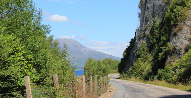
After a short lunch break, I continue onwards. Cliffs rise high to my right, while the railway line snakes along the left-hand side of the road.
I’m stepping off the map for a while. Although I usually buy a paper Ordnance Survey map for each stage of my walk, the next section is only a few miles (around the top of Loch Carron) and it didn’t seem worth the cost of buying the extra map. Anyway, I can’t get lost. All I have to do is follow the road.
So, when I come to a tunnel, I just think it’s an ordinary tunnel. It has two entry portals – one for the railway track, and another for the road.

[Later, looking at the OS map online, I realise the tunnel is, in fact, an ‘Avalanche Shelter’!]
From a distance the tunnel, looks starkly functional, even rather hideous, when I get closer I realise it does have some nice decorative flourishes.

Beyond the tunnel, the road bends away from the railway line, and rises steeply.
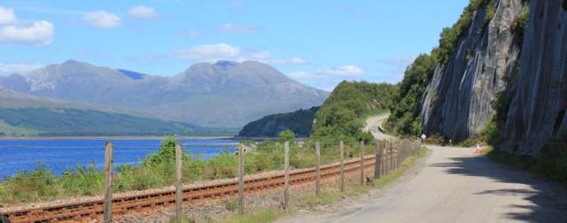
It’s a tough climb up the hill. A car pulls in beside me and the driver offers me a lift. Very kind, but I HAVE to walk ALL the way, I’m afraid.
The climb is worth it, because the view from the top is wonderful, overlooking a wide river valley.
Down the hill I go, dodging campervans and lorries, until I reach the flat land at the bottom. A road bridge takes me over the Attadale river, and a sporty open-top car zooms past. Now, I might have been tempted if that vehicle had stopped to offer me a lift…

I walk past the driveway to Attadale Gardens, where several cars are parked, and then past a pedestrian gateway. The gardens – the little I can see – look beautiful, but I don’t have time to stop.

Just beyond the Attadale Gardens sign is a station. Attadale Station. Another railway station stuck seemingly in the middle of nowhere.

[Later, I discover that Attadale might have been an important terminus, but the loch was too shallow to allow steamships to dock safely, and so the terminus was moved to Strome Ferry. According to Wikipedia.]
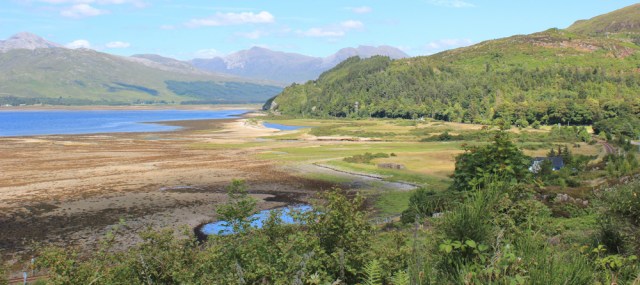
After crossing the flat bottom of the valley, the road climbs up again.

It’s even steeper on this side, and an even tougher climb, but again I’m rewarded by a wonderful view from the top. I’m looking down past the end of Loch Carron, and can see the River Carron winding along the valley ahead.

On a steep part of the slope, I hear gears grinding behind me, and I’m passed by a rather odd-looking ambulance. Not exactly streamlined – more like a brick on wheels, and dull-green colour. Very military looking.

And then by another one, this one is painted a sandy colour, and even has a blue light on top. Followed closely by a sandy-coloured land-rover type vehicle.

A whole string of similar, ancient ambulances grind past me. Are they really military ambulances? Or is there a special club consisting of vintage-ambulance owners? Or, to be specific, vintage-military-ambulance owners?
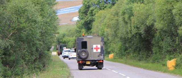
It’s a mystery.
Down I go, enjoying this section of the walk, despite the traffic. I’ve nearly reached the top of the loch.

The road flattens out, and I pass a pottery and craft shop, which doubles as a restaurant. Notice the little blue open-top car is parked outside and feel a flash of envy. If only I’d known you could get food here, I wouldn’t have bothered with a picnic and would have stopped here for lunch instead.

I’ve nearly reached Strathcarron. It sits on a grassy plain at the top of the loch, at the mouth of the River Carron, and is surrounded by meadowland.
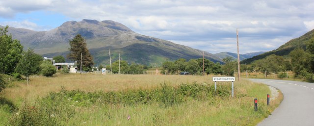
Sadly, at this point, my route will diverge from the railway line. Now, the main road sweeps round in a wide right-angle turn and crosses over the line, while the tracks continue straight up the valley.
Strathcarron has a station too. In fact, I caught the train to Strome Ferry from here this morning.
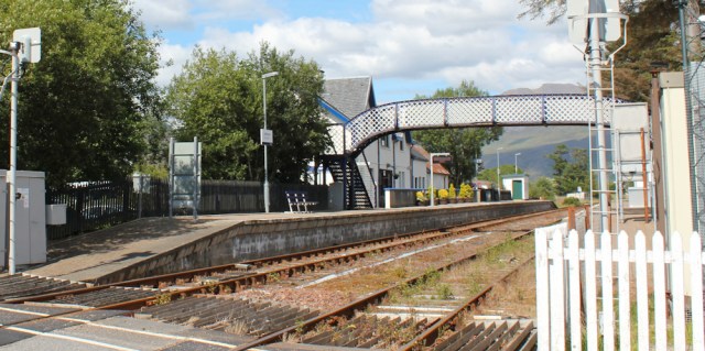
It’s been wonderful having a train service to get me to and from my walks. A real treat. So I’m sad to lose the line. From now on, I’ll be relying on a combination of The Beast and my Scooty bike.
Just beyond the platform is the Strathcarron Hotel. I guess it might have once been the station master’s house. It’s now just gone 3pm and, to my surprise, the bar is open.

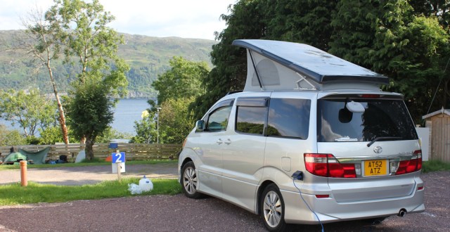
I check that my Scooty bike is still waiting for me. Yes. Still safely chained up behind the hotel. I rode it here this morning to catch the train, and will return for it later.

In the bar, I enjoy a leisurely pint of cider. Another treat. It’s rare I find a pub open at the time I want one!
A number of workmen are standing at the bar, discussing the recent bad weather. Nearby, a group of American ladies are chatting at one of the tables. I met them on the platform this morning. They were catching the train to Kyle, but I suggested they break their journey and visit Plockton too.
“Thank you for your suggestion,” one of them calls over. “Plockton was a beautiful place.” In fact, they enjoyed Plockton so much, they never got to Kyle.
I spend an hour in the bar. It’s good to have a rest on a proper chair.
Onwards. I follow the main road, crossing the River Carron via a bridge.

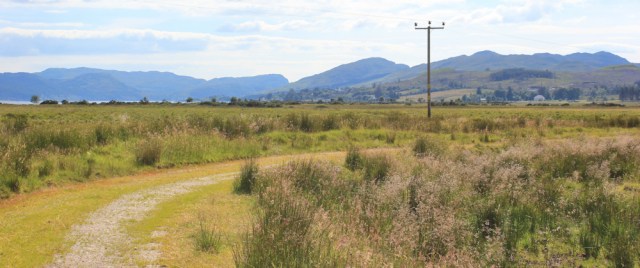
And, a little further along, I find a track leading off to the left. Lochcarron, 4km, says the signpost. Excellent. This is a shortcut and should cut out a triangle of road walking.

The track leads across fields. Hello sheep.

Not exactly a straight line, the route curves gently around, neatly bypassing a pine plantation. What a pleasant walk, and in warm sunshine too.
I come to a little stream, with a choice of two crossings. A metal footbridge, and a line of stepping stones. Which would you choose to use?
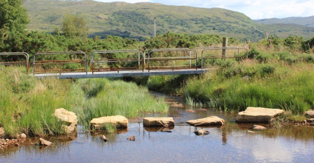
I choose the stepping stones, of course!
The track ends in a long, straight green stretch. There’s the road ahead. No longer the A890, which has swung round to the right somewhere, heading inland. This new road is the A896.

I join the A896 outside the Smithy Community Hub. Apparently it provides arts and crafts, shops, tree houses, events, pottery, etc. But it no longer provides Visitor Information, apparently, as these words have been crossed out.
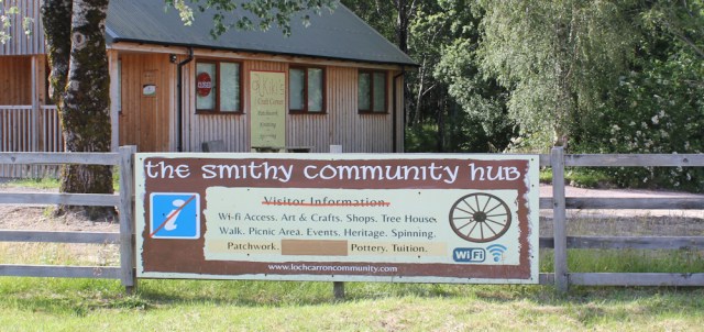
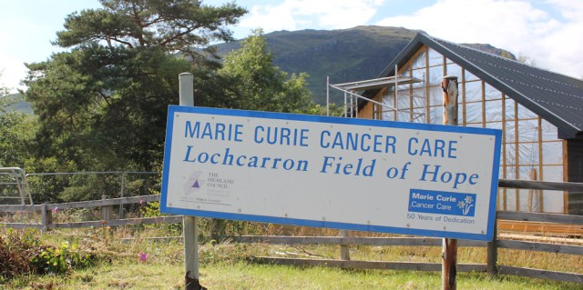
It’s closed anyway. Possibly for renovations, as there seems to be a new building going up beside the old one. Nearby, a Marie Curie sign leans sadly over a barren patch of land proclaiming, somewhat optimistically, that this is “Lochcarron Field of Hope.”
Despite it’s rural appearance, a lot seems to happen along this road. I pass a small industrial yard. It hosts a wide variety of businesses, a woodworking centre, a motor trader, storage facilities, and Lindy’s Laundry.

Further along is a golf course. A common site in the southern part of Scotland, I haven’t come across a course for a long time. Red flags flutter cheerfully in the breeze.

A new-looking chapel, with a graveyard of old and modern stones.

And, at the end of the golf course, there’s an aptly named café – the Tee-Off Café. Closed, of course, since it’s past 5pm.

On the right, I pass a tumbledown building, possibly an old chapel, standing among ranks of ancient grave stones. Very atmospheric in the slanting light of the afternoon sun. I stop and take photographs.

I’m approaching the village of Lochcarron now, and the road hugs the shore of the loch. Speed limit warning signs appear.

At a bend in the road, I turn and look back up the loch. Love those mountains with their wide, sweeping slopes, and the flat emptiness of the water.

A nearby bench provides the opportunity for a self portrait. For once, I’ve been able to shed my coat and walk with bare arms.

On the other side of the road is a primary school. Figures are painted along the wall of the building. I suppose they are intended to look like cheerful children playing but, when seen through the bars of the fence, they look sinister. Zombie prisoners trying to escape.

I’ve nearly reached the village now. It’s long and thin, consisting of the main road and a parallel lane, both sandwiched between the loch and the high hills behind. Obviously has some sort of bus service too.

A bright red truck sits on a patch of flat grass near the shore. ‘Incident Response Unit’. What?

It seems an incongruous thing to find beside the peaceful loch in a sleepy village. No sign of an incident. Perhaps it’s been dealing with the zombie invasion at the school?
On the corner is a small garage and petrol station.

[Later I learn the garage is very busy, due to the number of vehicles that break down on their way over to Applecross. And it’s the only garage around for miles.]
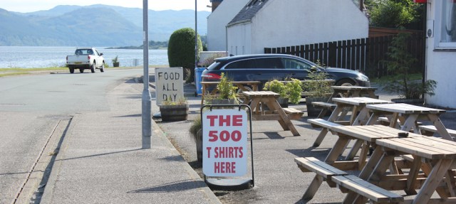
I pass a rather dilapidated hotel, and the first indication that I am well and truly on the NC500 route. “The 500 T shirts here.”
I leave the main road, walking up a steep little footpath that links with the minor lane above. It emerges at the campsite where I’m staying.
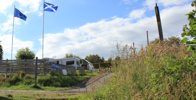
It’s a small site – endearingly called the Wee Camp Site – and takes not only campervans and small motorhomes, but tents too. The pitches are arranged on terraces, rising above the lane, so that every spot provides a good view over the loch.
I’m leaving the area tomorrow. Heading home, but not directly, because I’m stopping on the way. I have one piece of unfinished coastline to complete.
Yes, tomorrow I’m heading back to the Glenelg Peninsula. I’m going to find a way through from Totaig to Ardintoul – even if it kills me!
Miles walked today = 12.5 miles
Total around Scotland = 4,359.5 miles
Route:


Hi Ruth, I think the real reason for the covered road and rail sections is to protect from falling rocks, which caused the the road to close on a number of occassions over the years. The militart vehicles are all ex-military as they no longer have the Military Number plates, just the standard Road vehicle plates.
Ah, I was wondering about the real risk of avalanches. Rock falls seem far more likely. And I’m glad those military ambulances are no longer in use as military ambulances. They seemed awfully old fashioned!
The road walking looks unpleasant and quite dangerous too – though the view from the top is amazing. Strange to see all those ambulances together – maybe some kind of rally for enthusiasts.
Hi Karen. Yes, I think it must be a rally of some sort. A rare breed of vehicle!
Have driven through the avalanche shelter (as it is known locally ) many times and never noticed the decoration before. Remember a very good evening in the Strathcarron hotel some years back.
I was surprised to see the decoration. Rather unexpected.
Ruth,
I think that the presence of the blue sports car in the carpark means that you should have ventured into the place and had a meal! You never know what might have happened next!
Robin L.
Ah, the paths we might have taken… it was a rather nice car, but probably wildly impractical for Scotland!
Hi Ruth, suggest you pass your cycle lock through the bike frame as by removing the saddle it could easily be stolen ( or is that what your secretly hoping!)
PS great to have regular updates again, keep on walking 🙂
Hi Hugh, the green strap is just a strap, and you’ll be reassured to know I have an enormous D lock securing the back wheel and frame! I want to hang onto Scooty 😄
We were still following just behind! We visited Attadale two days later, though it was wet by then. The gardens were lovely with an interesting sculpture trail and a nice little do-it-yourself tearoom.
It’s another place on my list to go back and visit one day! A long list… 😀
My list is long too, one day, as you say. I’ll miss your walks, though I hope there might still be some to come from last year.
More beautiful scenery, I love the view from the top of the first hill after the tunnel 🙂
Yes, and the sunshine really helps to make the views even better.
I stayed in your ‘dilapidated’ hotel! – It wasn’t the greatest. Really pleased to hear you went back to Totaig!!!
Cheap and cheerful, I assume. They get bonus points for doing food all day.
Hello Ruth so lovely to be able to read your adventures in these extreme and extraordinary times. Thank you , photos are beautiful
Hi Jill. The world has gone mad, hasn’t it? Glad I can relive these walk, and glad I’ve still got a few more to write up. Takes me back to happier times.
I did this walk today but in two sections. I drove to Strathcarron and parked at the station and then walked to Lochcarron. I’m afraid I used the bridge (actually there were two bridges, one either side of the stepping stones) because after all the recent rain one of the stepping stones was under water. Lochcarron is very beautiful. Sadly the community hub was all closed, as was every cafe you pictured (presumably Covid). Attadale Gardens are open however (but the cafe there is still closed). Then I took the bus back to Strathcarron, drove to Strome Ferry and took the train back to Strathcarron (it was the only way to avoid a long wait for a train due to the infrequent service) and then walked back to Strome Ferry.
I managed to find a route along the shore from just outside Strathcarron (where I spotted a path over the railway line) to Attadale station. Sadly after that the only access over the railway line went to peoples private houses so no real way to get back onto the shore. I was passed by the Royal Scotsman train (https://www.belmond.com/trains/europe/scotland/belmond-royal-scotsman/) presumably heading for Kyle of Lochalsh at Attadale
Shame you couldn’t use the stepping stones. Yes, Lochcarron is a beautiful place, and I do wonder how local businesses have coped with Covid and the shutdown. Must be tough on the local economy. How wonderful to see the Royal Scotsman!
The decoration on the rockfall shelter was done mainly using a hot lightbulb to carve the thick expanded polystyrene sheets that lined the shuttering – I knew the person well who did it, he was a former colleague. I believe it was his idea, and done free of charge while he was working on site as an inspector with the consulting engineers.
That is fascinating. So glad he made the effort to carve the decorations on the shelter. Best wishes, Ruth