
[This walk was completed on the 15th July 2019]
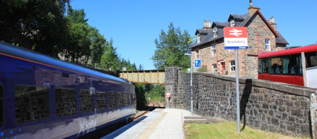
I get off the train at Strome Ferry, on a glittering bright morning. The train pulls away and leaves me alone on the platform.
Today, I’m going to walk up to the top of Lock Carron, and down the other side to a village also called, funnily enough, Lochcarron. It’s going to be a longish walk (for me), and most of it will be along the road, so I have mixed feelings about the day ahead.
I walk down to the Strome Ferry slipway. In the old days, the ferry used to run from here to North Strome. It’s just over there, on the other side across the loch. About 1/2 mile away.
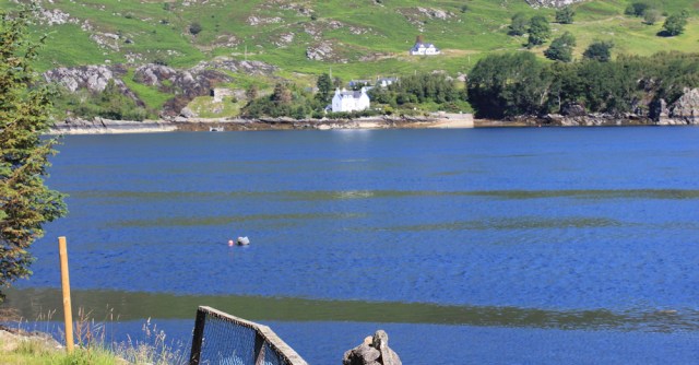
But no ferries run anymore, and North Strome is now a 20 miles journey by road. I guess this is progress?
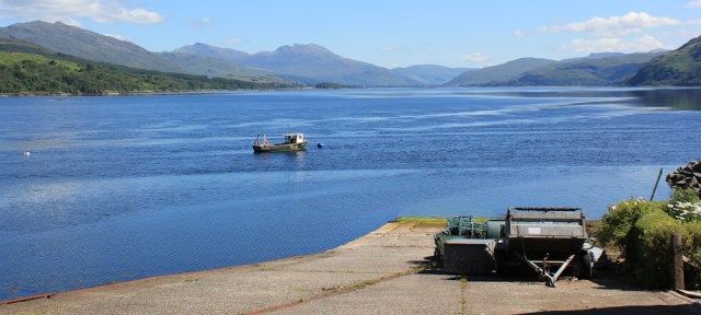
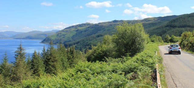
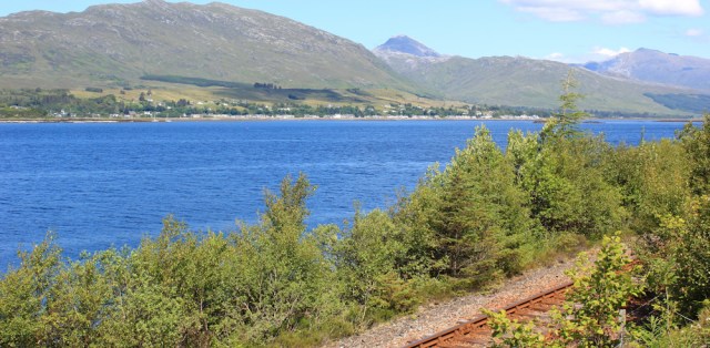
I turn to my right, and look up the length of Loch Carron. It’s beautiful. Thank goodness that summer has finally decided to arrive in Scotland.
Come on. Time to get gong.
It’s a steep climb out of Strome Ferry along the road. I pass my camping spot from the other night, and continue until I reach the main road. The A890.
Apparently, it’s only 11 miles to Lochcarron (I thought it was going to be more). But, oh dear. Look at the busy road.
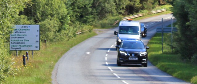
I trudge along the verge. Always harder than it looks, as verges are often soft, with hidden lumps and bumps, and strewn with rubbish. Not much rubbish along this road though. Northwest Scotland is such a clean place.
I’ve only gone a few hundred yards, when I come to the top of the hill and a parking layby with a mobile café. The smell of coffee is wonderful, and it’s a popular spot.
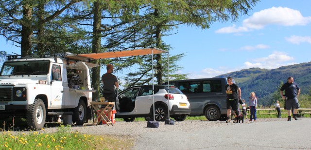
Parked in the layby are a couple of cars, a camper van, and some newly-arrived motorcyclists. This is why they’re here. For the coffee and, of course, for the wonderful view over Loch Carron!

A few days ago, along the shore of Loch Alsh, I passed a sign for the “Wester Ross Coastal Trail”. That, along with the North Coast 500 (NC500) route, is all part of a tourist scheme to attract more visitors to this remote area of Scotland. It seems to be working.
I haven’t yet reached the area where the NC500 route officially runs. But the whole scheme has had a knock on effect, and explains why it is now almost impossible to find anywhere to stay in a B&B or hotel across Northwest Scotland
It’s too early in my walk to stop for a coffee, so I take a few photographs of the view, and then continue plodding along the road.
My OS map shows tracks running through the pine forest below me, so I’m hoping to be able to leave the road soon. About a mile after the viewpoint, I see a track leaving the road at a sharp angle.

Check my map. Good. Although at first I will be doubling back on myself, this track should join up with a lower track. And from there I should be able walk off-road for a mile or so.
But, after trekking a few hundred yards down the slope, I can’t find any sign of the lower track. I turn back, reluctantly, and climb back up the hill to rejoin the A890.
There’s no sight of the loch now. I’m surrounded by tall trees, walking along a road that bends and twists, with steep drops and rises. 11% slope, warns a sign.
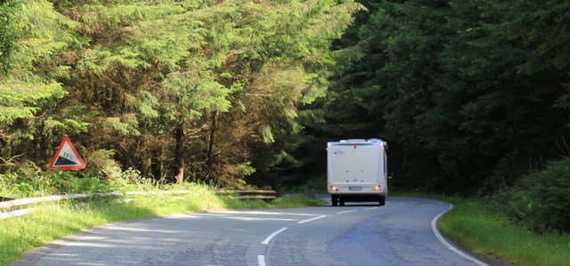
The traffic isn’t too bad, but I have to keep an ear out for approaching cars and – worse – the sound of labouring lorries and motorhomes. Gears crunch. Brakes squeal and hiss. Makes the walk quite tiring, as you can never relax and just get into the swing of it.

A mile along, and I come across the end of the elusive track I was hoping to find earlier. So there really was a lower track there, somewhere. Perhaps I didn’t go down far enough?

Oh well, too late to worry about that now. Onwards.
I’m approaching a place called Ardnarff. (Hard enough, says my brain.) It consists of a bridge and a cottage or two. That’s all.

The bridge appears to be damaged, and is fenced off with some highly ineffective barriers. A sign warns about falling rocks for 2 miles. Also, a handy number to phone to report any rock falls.
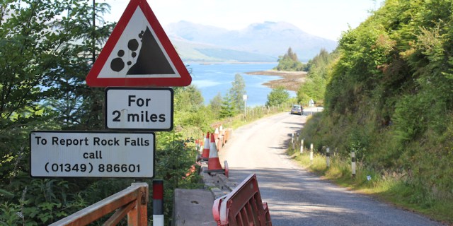
It’s a reminder of how fragile the infrastructure is in Scotland. One broken bridge, or one rock fall, could close a road for days. (I remember how my B&B at the top of Loch Hourn was cut off for months because of a landslide.)
Now, the road and railway track run together along a narrow strip of land, hemmed in on one side by the waters of the loch, and on the other side by the steep slopes of a ridge of high hills.

In some places, the slopes become rocky cliffs, and are covered in wire mesh to protect the road below from falling rocks.
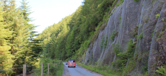
It’s a narrow road, which alternates between two lanes and becoming single lane. Personally, I prefer walking along the single lane stretches, because here the traffic seems to slow down, and is more considerate of pedestrians.

There’s a village over on the opposite side of the loch. Must be Lochcarron, where I’ve booked into a campsite for a couple of nights. I try to spot the site, and The Beast, but it’s too far away to see clearly.
Onwards. This road seems never-ending.

I come to a spot where a waterfall tumbles down the rocks on my right, and the water flows under the road to join the loch. It’s just gone 1pm, and time to stop for lunch. What a perfect place to have a picnic.

[To be continued…]
Route this morning:


That mobile cafe looks fantastic! I’d be much weaker willed than you and start off with a bacon barm and cup of tea, then cakes, ice cream, then…..
You’re so strong-willed, I am impressed!😊
If only it had been a bit further down the road… 😄
I got a complimentary cup of coffee when I passed the layby coffee shop, it was reallly nice The road was closed when I travelled through back in oct 2018, I had to take the high route over the hills as they were not allowing pedestrians through.
I got the impression rock falls were pretty frequent along that road.
We could with some of those blue skies now.
Yes, indeed we could. But they did follow weeks of cold and rain!
I remember having to walk a couple of very busy roads when I was ‘Walking The Black Dog’ from Land’s End to John o’Groats. The A9 between Inverness and the finish was particularly hard and I SO empathise with you about verges being much more difficult to walk than they look!
I don’t mind narrow, twisty roads so much, because traffic seems to go slowly. But hate it when cars and lorries are rocketing past at 60 mph – or more 😩
How weird, my comment from Friday seems to have disappeared 😦 Another glorious day and gorgeous views, I don’t think I could have ignored the mobile café though 🙂
Hi Eunice, sorry about the disappearing comment. Yes, another beautiful day. Rare and precious when they come.
Loch Carron is very beautiful. I told my Mum about your Plockton walk and she still remembers how pretty it was.
It really is a lovely area, Karen. I’d never heard of it before,
Gosh what wonderful weather you had for this walk. Mostly cloudy (but at least dry) for me. The mobile cafe has gone I’m afraid and that broken bridge still looks exactly the same. DIdn’t enjoy this bit along the road so much, too much traffic to pay attention too. I kept looking for legal ways over the railway to try and walk along the foreshore (having observed it was possible for much of the way and the tide was out from the train).
As to those tracks through the woodland – you did the right thing. Looks very very closely at the map and you will see there isn’t actually a continuous track through at all (I think from your writing that, like me, you thought there was from the map but like me also didn’t look close enough!). There is a tiny tiny gap in the tracks where the map marks “waterfall” so the two tracks are actually both dead-end tracks with the waterfall in between, which is much too steep to possibly cross. So both tracks appear to be dead-ends (for what purpose they exist I’m not sure). Rather than back-track I was able to climb up through the very steep woodland back to the road to correct my mistake.
Ooh, well spotted re that gap in the track. What a shame, because it would have been a welcome break from road walking.