
[Walk completed on the 10th May, 2023]
I’m back at Moine House, where I secure my Scooty bike behind the ruined building. It is a much brighter day today, and – despite the fact that the cycle ride was all uphill – I’m feeling refreshed and ready for a day’s walking.
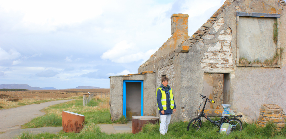
The plaque on the wall behind me is indecipherable now, but it once held the following inscription…

I’m reminded that whoever had the tenancy of the house was obliged to offer travellers hospitality as they made the treacherous journey across the bog between Tongue and Hope. Marginally less treacherous with the construction of the road, but still treacherous.
From Moine House, I’m hoping to follow the orignal route of the road down to the Kyle of Tongue. The beginning of the route looks promising – long, flat, and easy to follow. And I know most of the route will be downhill.

When I walk, I get occasional moments of pure bliss. It is hard to predict when this will happen, because it seems to be a random combination of good weather, lovely scenery but, most importantly, the right frame of mind. Anyway, this is one of those occasions. My heart is fairly singing with joy. This is excellent waking.
I make rapid progress, until the old road peters out… and my heart sinks at the prospect of having to walk along the new road, where there is little traffic but the traffic that does pass you comes thundering along.

But, I realise the old road continues on the other side of the new road. This section seems to have been used as a farm track, and the surface shows much damage. In addition, parts are flooded! Oh well, wading through this is much better than traffic dodging – onwards.

The muddy track swings back towards the main road… and continues as a much dryer track on the other side. My map suggests the track continues for a while until it hits the road again, so I cross over and carry on.

When I look back up the track, I can still see Moine House on the horizon. In the past, travellers across this bare, boggy land must have looked towards the House and used it as a waymarker. A safe refuge to aim for on a stormy day.

I head down the slope, towards Tongue. This is a strange section of track – with what look like wider areas and signs (long since faded into oblivion) that might signify these were passing places.
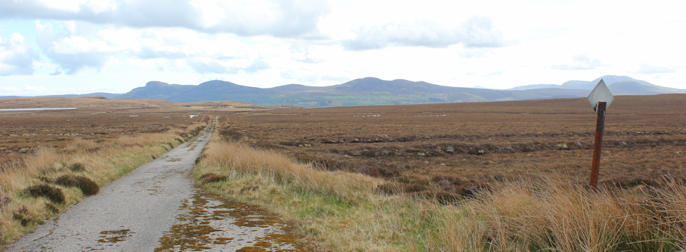
Surely motor cars didn’t drive along here? Far too narrow and fragile. It’s a mystery why these passing places – if that is what they are – exist at all.
I really enjoy this section of the old road, with its gentle downhill gradient and increasingly impressive views. Mountains ahead. Much more pleasant to look at compared to endless bog. Lovely.
Ah, here’s the road again, and no obvious continuation of the old road.

It’s time to pull on my high-vis jacket, grit my teeth, and hit the tarmac. But, I mustn’t complain. I’ve managed to miss out a whole chunk of road-walking and traffic-dodging.
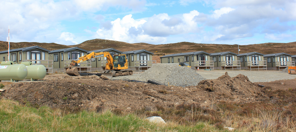
On the way up here, I was held up by traffic lights that controlled a long stretch of road that was narrowed into a single-lane by an endless stream of traffic cones. I couldn’t work out why this was the case, because there didn’t seem to be any road works in progress, just some building work of some sort going on beside the road. No real buildings going up either, but a lot of tarmac being laid down. Maybe they were making a new car park? But, why in the middle of nowhere? Another mystery.
Luckily, the old road reappears again. Excellent. This is a lovely walk.

I think they are missing a trick with all these great sections of the old route, because if you joined them together you could create a really fabulous cycle track across the flow country.
Oh dear, back on the road again. A blue sign on the opposite side tells me to turn left in a mile for the Craggan Hotel. A hotel? I wonder if they do afternoon tea and cakes? Even better news, the old road continues on the other side. Excellent.

After a while, the old road really does fizzle out, and I have to climb down a rocky embankment, and wade through some gorse bushes, to get back onto the main road again.
I’m nearly at the bottom of the slope now. Here is a turn off to Kinloch, 5 miles down to the base of the Kyle of Tongue, where there is a bridge over the River Kinloch. I guess that was once the nearest crossing point.
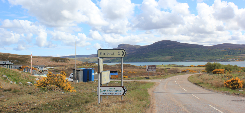
Just opposite this junction is more construction work. This time the aim seems obvious – the construction of a row of holiday chalets. Perhaps the other building site further up the road is also going to be a tourist park of some sort?
A short distance further, and I reach the turn off for the Craggan Hotel. Of course, it is CLOSED. Everything in Scotland seems to be closed!
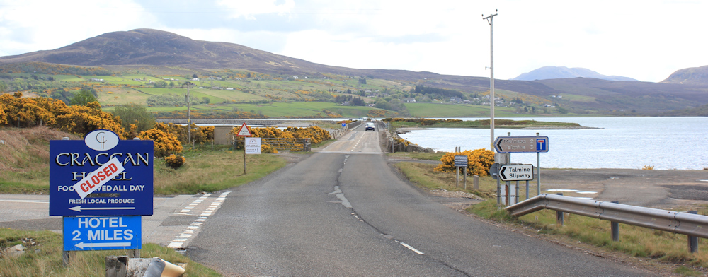
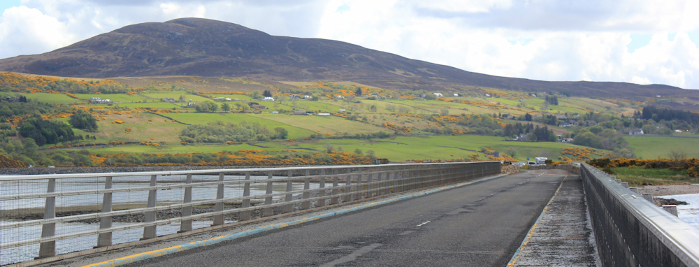
This is the start of the causeway crossing over the Kyle of Tongue. The first part is a bridge, rather than a causeway.
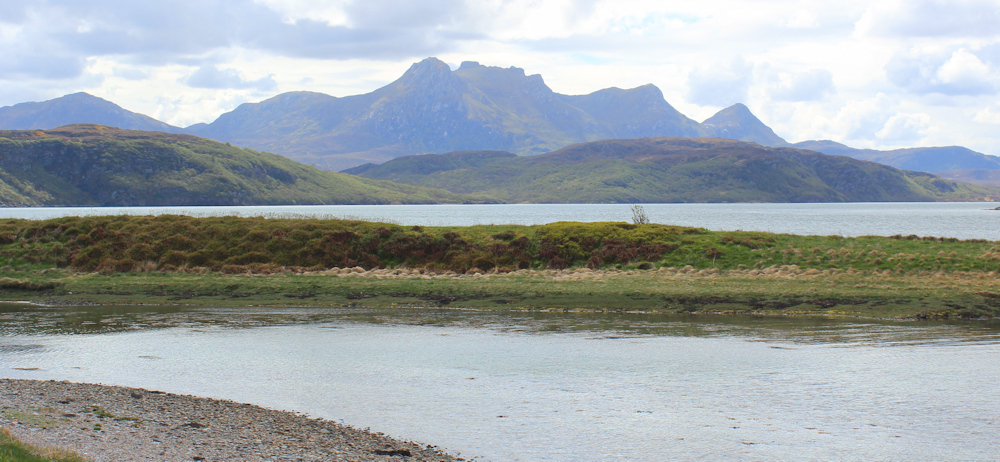
I stop to take photographs, looking northwards towards the distant sea. At this point, the Kyle looks more like a lake than an estuary. First thing this morning, the tide was out, and the place was just a mass of mud flats. Now it looks beautiful.

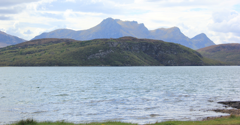
On the other side of the bridge is a great view towards that impressive range of peaks. Ben Loyal, according to my map. Also beautiful.
Further along, I reach a parking area, and spot a strange little statue beside the road. Quite small. Surrounded by a railing.

Oh dear, is it a roadside memorial to some poor child? No. A nearby information plaque tells me this little stone angel was placed here by the Unite Hope Project, and is an art project. This is one of a number of similar angels placed around the world.

I stop for a closer look. What a lovely statue. Simple, but perfect.

Here’s another information plaque. This one tells me that the Kyle of Tongue crossing was opened in 1971. I’m surprised it was so long ago. It feels a more recent addition to the landscape.

Another sign tells me what local wildlife to look out for. The usual otters and eagles, but it is the insectivorous plant that catches my attention. I remember the bus driver telling us there were 3 types of carnivorous plants on Cape Wrath. This sign only mentions one – the sundew.

I’m not convinced that these plants can do much to control the ravenous blood-thirsty midge population of northern Scotland, but at least the few plants that do exist will be well fed. Thank goodness it’s too early in the year for midges at the moment.
This part of the causeway really does NOT cater for pedestrians. Another opportunity missed to have a great cycle path / walking route between Tongue and Hope. I guess they weren’t thinking of such things back in 1971.
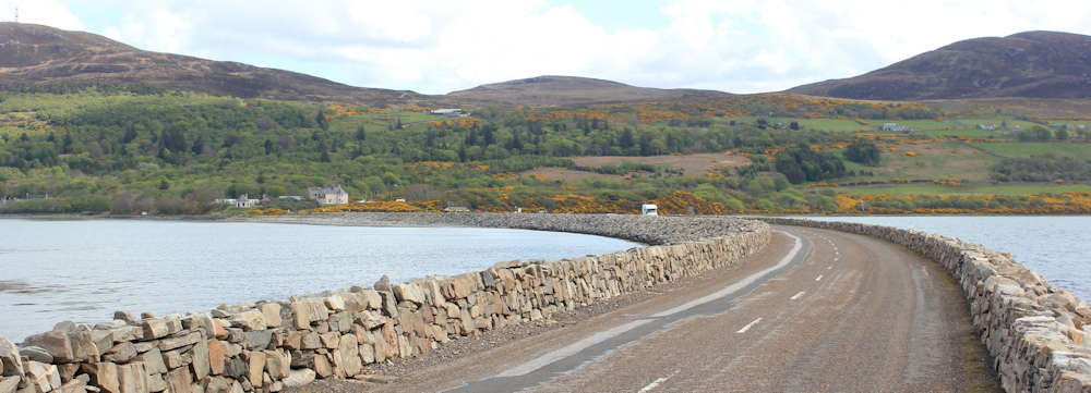
I take ages crossing the causeway. Keep stopping to take photographs. Just look at that fantastic view of Ben Loyal.
I pass another car park area, and now I’ve nearly reached the end of the causeway. I wonder if that funny little round house, directly ahead, was once a toll booth? My campsite is just beyond it.

It has been a fabulous walk this morning, and there is my lovely van waiting for me. Best of all, the campsite cafe is actually open (they are short of staff and it is closed in the evening – just the time when a hungry walker wants to eat). It’s nearly 2pm. I order a pie and a can of Fanta.

This little campsite is a real gem. You can’t tell from the photo above, but I have a perfect pitch with great views over the Kyle of Tongue. There is virtually no wind. And, it has single-sex shower blocks – the ones in Durness were mixed-sex and I hate that, so I used the family shower rooms instead.
Anyway, I pop into the office and book to stay an extra night because my progress is so slow. Part of me is frustrated with my inability to walk more than a few miles, but another part just wants to enjoy every minute. As far as scenery goes, it doesn’t really get any better than this!
This afternoon, I am off on a side detour… making the most of this wonderful area.
Route so far today:


Glad you had such a good day. It’s all about enjoying it and not a race (I sometimes need to remind myself of that!).
I remember I parked on the parking area on the causeway (probably where that artwork is) and did a long walk to Hope and back. I do remember making use of that old road and yes it definitely was a road and those are the passing places. I guess cars were narrower then and also I suspect the vegetation has grown over the edges of the road making it narrower.
Ah, so it really was once used as a road for cars. It would make a wonderful cycle track now.
Hi Ruth
I just love the descriptions of your walks and all your photos – would have loved to have done these walks myself, but am a bit older and have arthritis so can’t walk too far. So I feel you are doing it for me – the photos really bring it alive.
Thanks so much for sharing this
All best wishes
Margaret
Glad you enjoy reading the blog, Margaret, and thank you so much for your kind words. It’s very frustrating to have your mobility limited and I empathise.
More lovely scenery, I especially like the last two views along the causeway and the little angel statue looks so sweet.
Thank you Eunice. I did love the little statue.
Tongue is such an intriguing place. I would have liked to just sit and watch the tide go in and out.
I’d never heard of it, but it is a beautiful area.
Well done you, managing to get off onto sections of the old road. We should have tried it, but were put off by Helpful Mammal’s accounts of sections disappearing underwater (http://helpful-mammal.co.uk/2020/01/25/ccxix-durness-to-tongue/) So, conscious of 20 miles from Tongue to Laid, leaving little scope for time-wasting mistakes, we stuck to the main highway. Which, reading yours, I’m regretting.
As J Combe says the old road was definitely for cars. My family used it in 1968 when we drove from Durness to Tongue for dinner. It was a hell of a journey in those days and far longer without the causeway as you had to go all around the Kyle. Nature is slowly reclaiming it. I love the old passing place signs slowly disappearing into the peat. If it is not too late (I suspect it is) can I give you a tip re one part of the coast coming up depending on the time of year. Where Sutherland meets Caithness there is a big sign by the road. Opposite this sign if it is puffin time of year (Spring) head for the coast down a rough peat cutters track. It is only a fifteen minute walk. On the coast is a sort of pyramidal stack just offshore. On its sheltered side nearest the cliffs are hundreds of puffin burrows. It is quite possibly the best place to see puffins on the mainland and quite close up. The bay is known as Puffin bay but it is not its real name. Not well known about.
It looks so lovely up there, I’m really looking forward to this bit.
The three carnivorous plants will probably be all sundews, three different varieties, although it’s possible there may be butterworts and bladderworts up there too (I was really into carnivorous plants when I was a kid!)
I know exactly what you mean about mood. Some walks I just can’t get into at all, and other days I just feel so excited and free when I’m starting out. The sunshine definitely has a huge effect, but otherwise like you say, it can be quite random. I’m glad you had one of those moments… they’re great!
A lovely walk despite the traffic dodging. I’m glad you get those moments of bliss. I call them ‘little moments of joy’ and the smallest things can trigger the feeling.
Pingback: Taking route 2 – Outdoor Active are to develop the whole route. They are Friends of the North Highland Way.
Pingback: Taking route 2 | OutdoorActive