
[This walk was completed on Friday, 12th May, 2023]
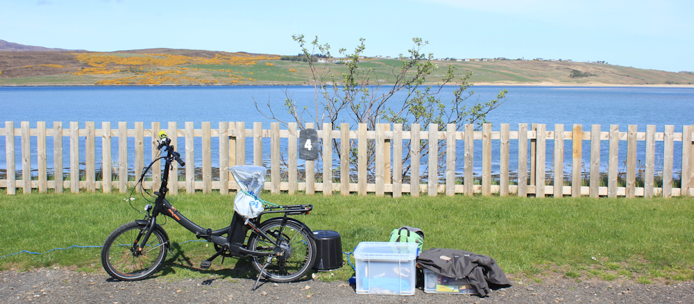
I start the day by driving to a place called Skerray, where I park my van, before cycling back to the campsite at Tongue. Chain up my bike in my camping spot, sling my rucksack on my back, and set off.
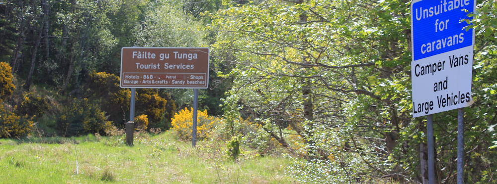
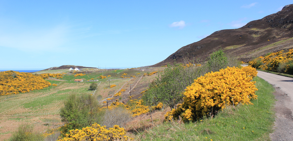
I am so glad I didn’t walk yesterday in the rain, because today turns out to be perfect for walking – with good weather and fine views. I take the little road that winds along the shore of Tongue Bay. A sign tells me this route is unsuitable for caravans, while a strange little hexagonal building watches over the bend.

What is the purpose of the little building? A toll house? Was this once a toll road? Or maybe something to do with a long-vanished ferry service?
The views across the Kyle of Tongue are dramatic. There is the causeway and the bridge. I can see the building site where they are creating more holiday homes, the main road winding up towards Moine House, and the little road to Melness where I walked a couple of days ago.

I’m not alone. Several people are strolling along the road, including a couple who are inspecting the remains of a pier. I wonder if it is still used?

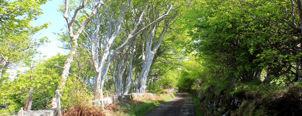
Further along, the road begins to climb, and I love walking beneath these elegant trees with their white trunks. They remind me of the trees in Applecross. I wonder what they are called?
All too soon, I join the main road again – the A838 has become the A836. Another sign warns the road I’ve just traversed is unsuitable for caravans – and also unsuitable for camper vans and large vehicles. Good job I didn’t know this when I travelled this way in my van this morning!
By taking the shortcut by the water, I’ve managed to bypass the village of Tongue. The cycling lady I met yesterday told me I wasn’t missing much in Tongue, where there is a very overpriced shop and an even more overpriced hotel – where one ordinary glass of wine at the bar set her back seventeen pounds!!!
I set off along the main road, heading away from Tongue. Haven’t gone very far when I spot this restaurant. “The Norse Bakehouse”. Surprise, suprise – it appears to be open. I make a mental note to stop here on my way back.

(Sadly, the cafe at my campsite is only open during the day, and closes in the afternoon – not much use when you’re out walking all day. It can be surprisingly difficult to find somewhere to eat in the wilds of northern Scotland!)
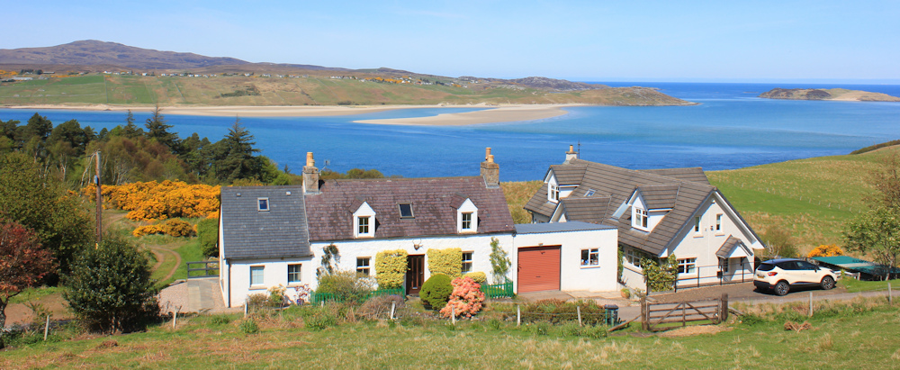
I was dreading walking along the main road, but it is suprisingly quiet, and with great views over the Kyle of Tongue. Love this little white house. What a great place to live.
The road has climbed higher, and I sense a massive bulk of mountain on my right hand side – although from down here I can only see the shoulder of the beast and some bare rocky slopes.
Over the highest point, the road begins to descend. Camper vans have taken up residence in a little parking spot, where a couple have set out their fold-up chairs and are enjoying the view… and what a view!

The road winds down, narrowing to single track as it negotiates a narrow ledge beneath a rocky slope. Ahead is a small settlement with a rather discouraging name – Coldbackie. Maybe this is the cold backside of the invisible mountain?

I stop to let a little post-office van overtake me, and then stop again to admire the view. What a lovely beach. Coldbackie beach. I’m tempted to walk down and explore – but the route down is steep and the beach itself is a dead-end.

Onwards. Just past the row of houses, where the road bends round the lower slopes of the invisible mountain, is a footpath. I’d already spotted this while researching the “core paths” in this area, and my plan is to follow the path and join a minor road, before doubling back to the main road again.
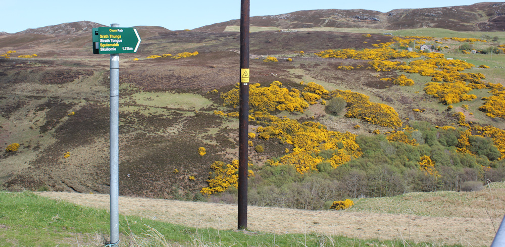
It’s not exactly a shortcut – more an extended diversion – but I can’t resist a core path, and it’s an opportunity to get off the road for a while.
My plan is nearly thwarted by a very stiff latch on a gate. While I struggle to get through, the post-ofice van overtakes me again, and then a motorcyclist pulls up beside me and a Scottish voice asks, “Do you need some help here?” Just at the same moment, the latch finally slides open, and I can say, “Thank you, but I’m through now.”
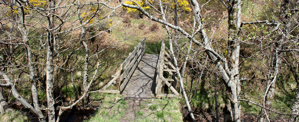
The first part of the route follows a wide, easy track going downwards.

It soon degenerates into a narrow path, and descends deeper into the valley. At the bottom, a surprisingly well-constructed bridge takes me across a wide stream – the Strathtongue Burn.
On the other side, I soon lose the path on the steep bank, and end up scrambling upwards through bog and bracken, holding onto coarse grasses to stop myself from slipping back down, and fighting my way through little patches of prickly gorse.
Why, oh why, did I choose this route?
Ah, thank goodness. Here is the path. I don’t know how I managed to lose it in the first place – but I’m glad to find it again.

From my vantage point across the little valley, I get a clear view back to Coldbackie. And there is the invisible mountain – the one I couldn’t see from the road before. What a lovely beast he is.
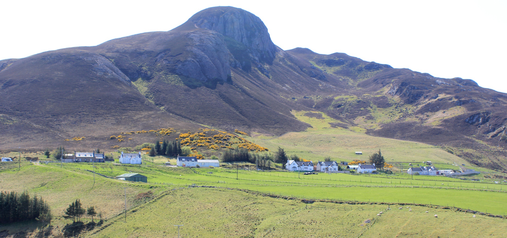
I check my map. It’s Ben Tongue. Of course! Well, I’m glad I followed this diversion now – it was worth it just to see this view.
The path continues a little way further, and then joins the side road. How enticing that little road looks, curving between banks of fragrant gorse.

I was planning to walk further along the road to a place called Scullomie, where apparently there is a little harbour. But, despite my rest day yesterday, I’m feeling surprisingly tired. And Scullomie is a dead end.
Do I go forwards, or not? I stand dithering for a moment, and enjoy the view across the Kyle of Tongue – look at the colour of that water! Must make a decision…

… and I end up turning away from Scullomie and heading straight back towards the main road. I haven’t gone very far, when I have to step to the side to allow the little PO van to overtake me again.

Near the end of my side road, at a place marked as Blandy on my map, I hear a voice calling out a name. It’s woman in a garden beside the road. At first I think she has lost a child – but it turns out she has lost her kitten. Not just one kitten, as I discover later, but two kittens.
I stop for a chat. She envies my camper van and then talked at length about how the area around Tongue has been spoiled, in her view, by a man named Poulson (later, I realise she is talking about a Danish billionaire called Povlsen – who I had heard about before, as he has been busily buying up massive tracts of land in Scotland and converting them back into natural woodland – a practice I heartily approve of.)
Anyway, Povlsen now owns much of Tongue and local people, including her own sister, are unable to buy houses here. He is also responsible for the overpriced hotel selling the infamous overpriced wine at £17 a glass. She also told me about Hope, which I walked through a few days ago and is currently a massive building site. Apparently Povlsen is turning this into an exclusive tourist resort – with a huge underground car park where millionaires can discreetly park their very expensive luxury cars.
She is, understandably, very upset about these ventures.
Then, she asks me if I’ve seen the spaceport. Spaceport?!
At first I wonder if she is a mad conspiracy theorist, but then I remember the strange building site I passed on the road between Tongue and Moine House – where they seemed to be constructing a car park in the middle of nowhere. Turns out it’s not a car park, but a spaceport. This will be visible from her cottage and is causing her great concern. Although they promise there will only be one satellite launch a month, they can also rent the site out for other companies to use.
I’m not sure I really believe her, as it sounds a little crazy, and I assume this is another Polvsen project, but she soon sets me straight. “No, and even Polvsen couldn’t stop it!”

While we were chatting, her two kittens saunter up and start hunting in the surrounding verge. They are really teenagers, rather than kittens, and are the most beautiful young cats. White with smoky-grey points, and gorgeous blue eyes. One is hers, and the other belongs to her sister – the one whose house-buying plans were gazumped by Povlsen.
She kindly invites me in for a cup of tea, and I’m tempted… but I have miles to go before I reach my van, and I must press on.
Onwards.
I soon reach the end of the side road, where it joins the main A836. The little loch across the road is called Lochan Dubh, meaning Black Water or Black Pond. I’ve seen many Lochan Dubhs in Scotland, but this one actually looks blue.

I realise I am feeling hungry and perhaps that is why I also feel so tired. It is nearly 3:30pm and I haven’t had lunch yet. I must find somewhere safe to sit and enjoy a snack.
[To be continued…]
You can read more about Polvsen, and his Scottish empire, on Wikipedia.
Turns out the story about the spaceport is indeed true, and you can find out more about the spaceport on the Orbex site.
Route so far:


The colour in some of those photos is superb.
Thank you. I carry a decent camera with me, so it is thanks to the equipment that I manage to get some good photographs.
Fabulous views on this one, especially the one with the white house and Cold Backie beach 🙂
The one with the white house is now my desktop background. Looks lovely, doesn’t it.
We stayed in the Tongue Hotel once, clearly long before Polvsen’s time as it was nothing like that price!
I think he is catering for a certain sort of tourist. Shame that, despite all his good work with the rewilding of Scotland with native trees, he seems to be oblivious to the needs of local residents, and impoverished British tourists!
I’m still following with interest and some envy. I’d have been much tempted to make an ascent of Ben Tongue, it looks like a little classic. At 302m it only qualifies on Hill Bagging’s extensive collection of “lists” as a Tump, one of the lesser classifications, but I’m sure it must punch above its weight. It seems along time back to last May and your glorious weather as I look out at yet another dismal day here in Arnside.
Hi Conrad. I hope you are keeping well. Surprised to discover Ben Tongue isn’t a mountain – I think because it rises directly from sea-level it gives the illusion of being higher than it really is. The views from the top must be magnificent.
Ah, you’ve a stouter heart than mine Conrad – the *last* thing I would have wanted to do is climb all the way up there!
Hi Ruth,
I must pick you on two points in your TR. The first is the mountain you refer to as Ben Tongue is actually Cnoc an Fhreiceadain, Ben Tongue sits behind Cnoc an Fhreiceadain and is slightly lower and more rounded.
The second point is although the metal road ends at Scullomie, a rough track heads along the coast to the ‘cleared’ settlement of Sletell, although one of the crofts was occupied until as recently as the 1960’s. From Sletell, a marked footpath descends to Strathan.
Actually, come to think of it, I remember a number of cattle loitering around Sletell (all docile though), so maybe not a bad thing in avoiding this route,
I wonder if I would have climbed the wrong mountain if I’d been there? A bit like that Morecambe and Wise André Previn sketch – the right mountain but the wrong name? I checked Cnoc an Fhreiceadain on Hill Bagging – it qualifies as follows:
Tump (300-399m), Subhump, Yeaman
(Tu,3,sHu,Y)
It’s a while since I’ve browsed Hill Bagging – I was not aware of Subhumps or Yeamans.
Ah, thank you Alan. My map reading skills let me down on this one… but i must say that the higher hill *deserves* to be called Ben Tongue.
Great pictures again Ruth, that gorse looks amazing. I love gorse… except when I have to walk through it.
Glorious views and colours, a splendid walk.
The Spaceport may be carbon neutral and environmentally friendly but Orbex have shown no consideration for either the locals or the beautiful landscape. Someone has lot of money to get that planning application through!
As for Polvsen, I hope not many people get caught out by his inflated prices. The only good thing about his tourist resort is that the car park is underground!