
[This walk was completed on Sunday, 14th July 2019]
I wake up to scattered clouds and a blue sky, and a wonderful view from my campervan looking down over Loch Carron.
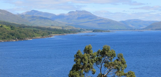
I’m in no hurry to get going this morning. After a late and leisurely breakfast, I pack up the The Beast, and then walk slowly down to Strome Ferry along the road.
I stand at the top of a slipway looking over the empty loch. Is this where the ferry used to run from? Hard to imagine now. Such a sleepy place.

The railway station is close to the slipway and I am, once again, the only passenger waiting for the train. This always makes me worry. If a service is not used, the service soon stops.
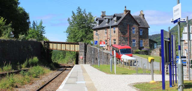
I have a long wait because I misread the timetable and forgot it was a Sunday today. The trains are infrequent. [Actually, I’m lucky there are trains running on Sunday at all. Later I discover Strome Ferry station was once the scene of riots over this!]
We pull into Plockton station just after 1:30pm. I walk down the road to find the footpath sign I spotted yesterday. A man in yellow wellies, with a dog, is heading down the same footpath.

I hold back to let him get a good head start, then I follow down the path. After steeply diving down the slope, it crosses a marshy area via a boardwalk, and I emerge at the side of a small creek.

With the sun in my eyes, photography is difficult, and the place would look much nicer with the tide in. Still, it’s a very pleasant walk, and a lovely change from road walking.
I’ve nearly reached the mouth of the creek, when I catch up with the man in yellow wellies. He’s sitting on a rock, and throwing a ball for his dog, a lively springer spaniel.
The spaniel reminds me of my daughter’s crazy spaniel, Lottie. Since I’ve moved to Manchester, I spend a lot of time looking after Lottie while my daughter is at work, and have totally fallen in love with her.
Anyway, I start chatting to the man in yellow wellies. Turns out the dog belongs to a friend, who can’t walk the dog at the moment because the naughty creature knocked her over and she is badly injured.
That’s the trouble with spaniels. Crazy things.
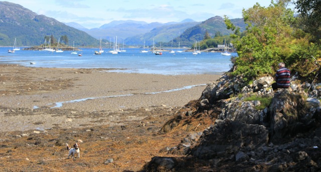
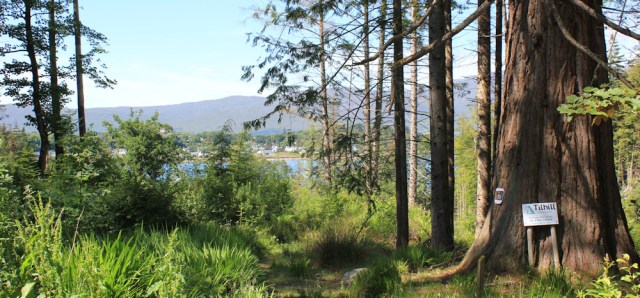
I walk on and, as I emerge from the creek, get a great view across the water to Plockton. I can see the car park where I left my Beast yesterday. It really is a beautiful place, and looks even better in sunshine and under blue skies.

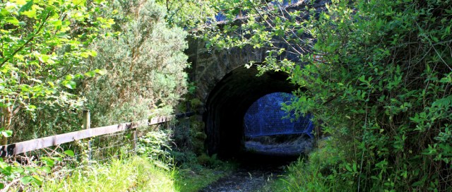
The footpath leaves the water’s edge, and turns inland, passing under the railway line via a tunnel.
A mysterious message on a post…. “CLOSE”. Close to what? Oh, silly me. It means close the gate. A gate that is no longer there.

Beyond the tunnel is a steep slope covered in metal mesh to prevent landslides, and another message – on a startlingly pink sign – tells me to beware of falling rocks.

I have the same reaction to this as to the signs warning me to beware of flying golf balls. How can you beware of such things? By the time you see one coming, it’s too late.
Now I’m walking through an area of woodland, along a muddy path lined with ferns. I reach a crossroads, hear voices, and a family group joins my path.

I stand at the crossroads and examine the sign. Duncraig Castle is my first destination. I wonder how ruined it will be and whether there is public access.

Although it’s disappointing to be, yet again, inland of the coast, I really enjoy this forest walk. It’s a wild area of woodland, with fallen trees and growths of different ages.

I come to the edge of an open area. Another tidal creek. There’s the railway line, passing over a bridge and close to the shore.

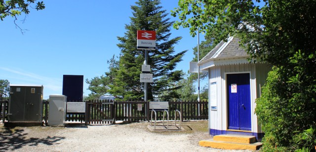
A little further along, the path joins a track. I turn left along the track and discover Duncraig Station. It has a pretty little waiting room, an empty platform, and is surrounded by woodland. Another station in the middle of nowhere. I wonder who uses it?
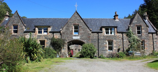
I turn back from the station and walk along the track. Ah, there’s the castle ahead. Oh…

… I’m somewhat disappointed to discover it’s not a real castle after all, but a Victorian stately home.
A dog comes bounding out of a door, barking ferociously, and is called back by someone inside. So people live here? Is it private property or open to the public?
The track – a wide driveway now – takes me past the front of the house, where I notice some signs. Looks like the place is currently closed for refurbishment. Re-opening time appears to have been changed from spring to summer. The health and safety notices are old and weather beaten, so I guess the refurbishment is taking longer than anticipated.

Well, it is an impressive place. I turn on the drive to take some more photographs.

I’m walking uphill now, away from the house and towards the main road. On a bend in the drive, I find another old building. Looks like the stable block, now converted into flats. Or maybe it was once a working farm with a central yard.
The sign above the door catches my eye. “Fear Cod”. What??? I walk nearer.
Oh, silly me, “Fear GOD”. And I must also “Work hard; be honest.” Maybe it was some sort of workhouse?

Onwards along the drive, which climbs higher and, through gaps in the trees, I can look down over the loch and Plockton.
Another sign catches my eye (it really is a day of signs today!). “Please do not let me follow you as I will get lost.”

What a sensible sign. It even provides the address and phone number of the owner.
I’ve had dogs follow me on my walks on several occasions, and it puts you in a difficult dilemma. Is the dog lost, and is that why they’re following you? Or are they close to home and about to get lost because they are following you?
There’s no sign of the wandering Maisie today.
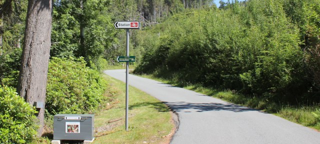
I reach the road, where a sign points the way back down to the station. I wonder how many people use that platform? Nearby, is a big grey box from which you can buy free-range eggs.
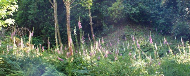
The main road is narrow and very quiet. I’m surrounded by woodland, with the sun streaming through gaps in the canopy. Foxgloves stand tall amid the ferns.
The slope on either side of the road is steep. High hills to my right. A sharp drop down towards the loch on my left.

I begin to pass silhouettes of animals stuck onto trees. A chicken, a rabbit, a goat, and a sheep. Painted black, and without features, they look a bit ominous. Like pictures of bulls on field gates, are they meant as a warning?

Ah, no. They’re adverts. I’m about to pass the entrance to Craig Highland Farm, where I spent a couple of nights recently.
The farm was an amazing place, with llamas on the lawn and lodges set against the loch. But the electricity was dodgy and the water from the taps ran brown (a fact that is hidden by the dim lights, and that I only discovered on the morning after I’d drunk a whole glass before bed!) So, perhaps not surprising, they usually have vacancies.
Looking down through the trees, I try to spot the lodge I stayed in, but it is obscured by foliage to the left of the photo below. My window looked out over the island with fir trees, and I didn’t realise that Plockton was so close, just hidden from view around the corner.

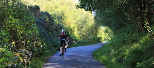
A cyclist overtakes me. I think of my husband and how he would enjoy this area, but then remember he is soon to be my ex-husband, and I push him away from my thoughts.
The road emerges from woodland, and swings inland, running alongside an area of flat pastureland.
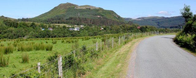
Ah. Look at those sweet little calves. I’m glad they’re on the other side of the fence. How lucky those cows are to have such a lush, green pasture to enjoy.

They’re water meadows, I guess, because the road is about to swing round and cross over a river via a bridge. A big blue sign says “Achmore Bridge Refurbishment”. What is being refurbished? I’m not sure. There is no sign of any work going on.
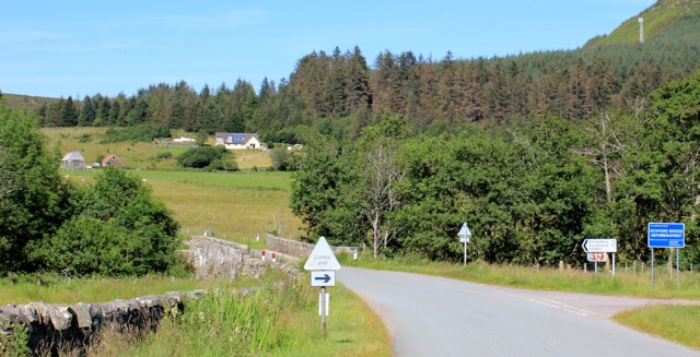
Over the bridge, and I’m entering the village of Achmore. (For some reason, I keep reading this as Ache More. Perhaps because my legs really are aching and I’m feeling unusually tired.)
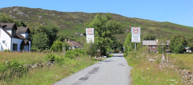
Achmore is a one-street village, and soon passed through. The road climbs a steep hill. Oh dear, I really am tired. Yes, I do ache more.
Luckily, at the top of the hill, the village has provided a handy bench. Time for a rest. I check my watch. It’s 4pm. Time for a snack too.
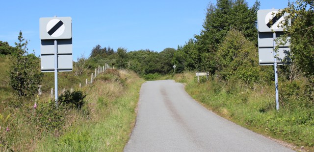
Onwards, to the end of the road, where it joins the busy A890. There are no pavements, and I haven’t been looking forward to this section. Put my head down and march along quickly, dodging traffic.
Luckily, there is only half a mile to go before I reach the turn off to Strome Ferry. Now here is something odd. Both my map and the railway station spell the place as two words: Strome Ferry. But the road sign combines the two words into one: Stromeferry. I’ve noticed in Scotland that the spelling of place names can be rather fluid!
The road sign has added a helpful description after the name, although – perhaps unhelpfully – it is printed in writing too small for a passing car to easily spot. “Stromeferry (No Ferry)”

I wonder how many cars have driven down to the slipway hoping to catch a ferry across Loch Carron?
The minor road to Stromeferry is very quiet, and I soon reach the car park where my faithful Beast is waiting for me.

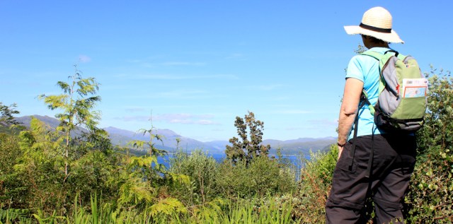
I’m sorry to be leaving my lovely camping site, and I stand and admire the view for a few more minutes, before perching the camera on the nearby bench to take a self portrait.
Oh dear. Is that my best side?

My second attempt is better!
It’s only been a short walk today, after several successive days of short walks, so I’m not sure why I found the last couple of miles so tiring. Tomorrow will be a longer day. But, now, it’s time to drive on to Lochcarron, where I’m booked into a campsite for the night.
Miles walked today = 7 miles
Total around coast = 4,347 miles
You can read about the history of Stromeferry, and the riots at the station, on the Undiscovered Scotland site.
Sadly, at the time of writing this (March 2020), Duncraig castle is still shut. Place looks fabulous though. https://www.duncraigcastle.co.uk
Route:


14th July was a beautiful day, which we spent in Applecross. We did part of the walk you describe here a couple of days later. The castle prices will make your eyes water!
Wow, yes. It really is expensive!
Yes, I’m still following your fascinating and often amusing blog! Great photos. I’m the guy who walked a little bit of coast from Brighton to Hastings last June, raising £1200 for Marie Curie. Later I extended this (unsponsored) to Dover, including Lydd and Hythe ranges on non-firing days, and I hope to continue to Margate and maybe London this year. Your marathon trek is a real inspiration – is it 10 years now? Keep going, look forward to more instalments. The east coast will seem so easy after the Highlands. Patrick (Rye)
Hi Patrick, and well done on completing your walk and for extending it. Yes, it is 10 years this April. Can’t believe it’s taken so long, or how far I’ve come. Everybody says the east coast will seem a doddle after northwest Scotland. Here’s hoping that’s true 😀
What a lovely write up and beautiful photographs. It looked like perfect conditions for this walk (well other than the tide perhaps). Regarding Strome Ferry I’ve seen photos of that road sign before but not actually seen it myself. I love it and hoped you’d include a picture of that. As to how neccessary the “no ferry” part is well I doubt many people just pull up in a place with ferry in the name to see if there is a ferry and where it might run to!
As to the stations it’s very difficult to close a station as any objection will lead to a (costly) public enquiry. Often the train comapnies franchise agreement will dictate the minmum number of trains that can be run (and where they stop). In some cases the stations were built as part of the condition of building the line when the landowners sold the land to the rail company to build the lines in the first place and put in a condition that a station must be provided for their use. That is often a reason you’ll find a station in the middle of nowhere!
Reassuring to hear about the train routes and stations. The station near Duncraig Castle was once a private station, owned by the owners of the castle. Now open to the public, but I have no idea how many people actually use it.
Been following your progress for quite a while now around the Scottish part of your walk. This walk you have done must be one of the most beautiful i have seen. Some days the scenery is quite uninspiring and unattractive but oh what a lovely part you are now walking. You are such an inspiration. Keep on walking.
Thank you for your kind words. Yes, this is a very beautiful area.
You certainly got good weather for this walk. I love the views, especially the first two 🙂
Hi Eunice. After several days of rain at the start of my trip, the sunshine over the past few days was really welcome.
A beautiful day with wonderful views and photos.
Thank you Karen.
I’ve used Duncraig station – when writing Remote Stations. I stayed in Plockton and walked on the same path that you did – and also wondered what one is supposed to do if a rock falls on your head.
I did have my own little accident though, falling and dislocating my finger on the bridge by Duncraig station. I walked up to the castle to see if I could get some water to clean it and the chap there very kindly gave me a lift to Broadford Hospital in the Isle of Skye, the nearest A&E.
As always your photos make we want to go back to these remote places.
Hi Peter. I wondered if you’d written about this station, and that reminds me I really must buy your book. I’ve always thought that when I get too old and doddery to walk, I might travel around the UK by train, going along all the branch lines and visiting remote stations. Sorry to hear about your accident. Very kind of that chap to give you a lift.
Stunning photos Ruth! It looks lovely up there.
It’s strange that tiredness thing isn’t it. You’re clearly very walking-fit, but some days it’s just so much harder than others, even when the distance is shorter. I have a theory about it but i wouldn’t dare mention it to a doctor – it’s probably really stupid! 😊
Thank you Paul. Yes, tiredness is a strange thing, and I know you too found a recent walk strangely difficult. I have no real medical explanation, so would be delighted to hear your theory. Unlikely to be stupid!
Well, ok then! When I was younger I did athletics, 400 metres in particular, which is probably the highest energy-output distance of all – i’d get my heart rate up to 240bpm. Some days I would feel ok, go to training but end up collapsing during training, then the next day come down with a cold.
My theory is that maybe some days we have an underlying illness or infection which is so mild we don’t notice it normally, but when it comes to exercising only then does it start to affect us, making mild exercise like walking harder, and hard exercise impossible… am I talking rubbish? Probably, I usually do!😊
Gosh, I had (almost) forgotten how stunning this area is. Thank you so much for the vicarious travel ☺️
I suspect Paul is “onto something” as I have also had “lead legs days” when the physical fitness was theoretically there to easily manage the planned walk, but it just doesn’t happen. Of course it could equally be blood glucose levels, hydration, whether you ate the right carb/protein/fat ratio the day before, or something completely different.
Hiya Jayne, it could be diet too, yes, but I can’t ever imagine I’d be low on carbs – cakes have loads, don’t they?😊
I did this walk today and not much has changed since you did it. The sign at Duncraig Castle now says it’s opening after refurbishment in Spring 2021! I do wonder if it will ever open (though the website does suggest they are taking bookings for 2021). I did meet Maisie the dog too (the sign is still there) but she didn’t follow me. I was very pleased to find that footpath from Duncraig to Plockton, squeezed between the railway and the coast it was very nice. I think the route might have changed a little however because (following it from the Plockton direction) I came out only a few metres from the end of the private road to the castle (by the junction with the public road), which did have a wooden footpath sign to Plockton. So I decided to walk along the track to see the castle (though I didn’t go down to the station) anyway. The rest I stuck to the road like you.
Unfortunately a big problem was the weather and transport. Heavy rain all day. In the morning I went to Eilean Donan castle and then decided to do this walk later in the morning and into the afternoon in the hope the rain would ease (it didn’t) but at least most of the walk even the road bits is in woodland so I was partly sheltered from the rain. It being Sunday only two trains run in each direction. The morning train was cancelled due to “severe weather” so before leaving Strome Ferry I checked the afternoon train was running (which I planned to catch on the way back). Having found that it had already left Inverness on it’s way to Kyle of Lochalsh. I thought all was good. When I reached Duncraig I could see the train was now 1 minute late and was due to pass me in 2 minutes. I waited 5 minutes and it didn’t pass. When I reached the shore I checked again and now it was 25 minutes late. Unfortunately the return train back from Kyle of Lochalsh that I planned to catch was now shown as cancelled due to “severe weather” (and it was the last one). I decided to continue to Plockton anyway and used the “help point” at the station and was told that it was indeed cancelled and there was no replacement bus or taxi due to “poor road conditions” and I’d have to make my own way back. So I had no choice but to walk all the way back again! Very frustrating how unreliable public transport is in North Scotland I hoped the train might prove more reliable than buses but sadly not.
When I got back to Strome Ferry several Network Rail Vehicles passed me going up and down the road (presumably to and from the station) so I suspect there may have been some damage or flooding on the track. When I got back to Kyle of Lochalsh the train is still here in the platform and the first train tomorrow is also cancelled so I suspect indeed there might be a problem with the track.
Thanks for postiing this