
[This walk was completed on Saturday, the 13th May, 2023]
My walk begins in Skerray, in the parking spot where I ended yesterday’s walk. It’s another beautiful day of sunshine, and I’m surrounded by the coconutty smell of gorse bushes in full bloom.

I pass cottages along the road, – Skerray is a strung out kind of village. I stand aside to let a boat on a trailer go past.

A crowd of people are ahead, spread acoss the road, and I approach the group with some unease. Seems to be a group of locals gathered for a chat. Then a friendly voice calls out, ” Hello.” It’s the lady with the cats from yesterday. Nice weather, we agree. “You must have brought it with you.”
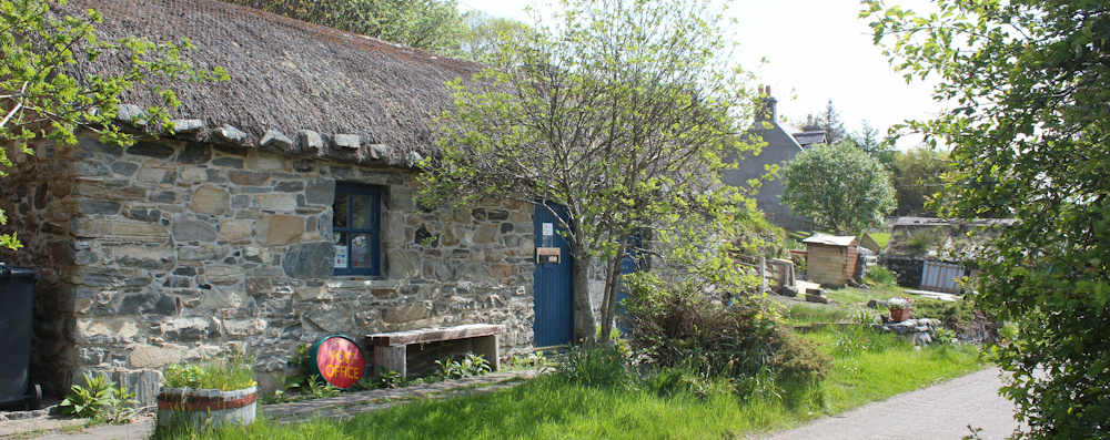
Onwards. I walk past the Post Office. It’s closed, whether temporarily or permanently isn’t clear.
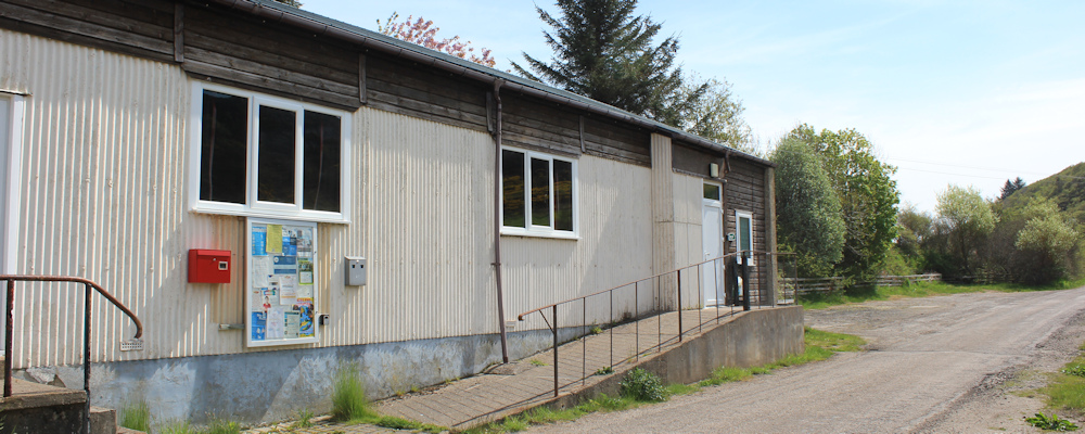
And then I pass the village hall. There is a new-looking defribillator attached to the wall, and a faded notice on the board that reads “Skerray Hall Committee members needed.” The sheet of paper is dated August 2022. I wonder if they found any new members.
Further along, a house is being built. Timber cladding on the outside. A man and a woman seem to be working on the project. I stop for a brief chat. It’s a DIY prefab house kit and they work on it at weekends because they want to live here – quite an undertaking! But the couple seem to be making good progress.

There is the war memorial, next to a house with a tin roof… oh, not really a house. Looks like an old chapel, but currently disused.

Nearby, in what might be the heart of the village, is a faded old phone box, and a more modern-looking post box. Shame about the abandoned caravans and car cluttering up the field behind.
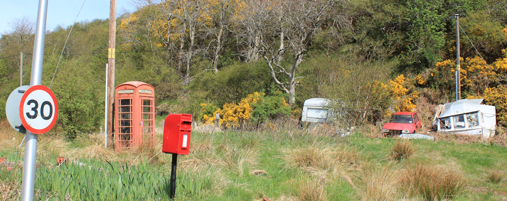
I plod across the boggy grass to check out the phone box. There is no sign of a path, so i’m guessing the phone is not used very often. Yes. It is actually in working order, somewhat to my surprise.
A wonderful old “TELEPHONE” sign is attached to the telegraph pole near the phone box. I’m not sure if the hole is due to rust, or whether it’s a bullet hole!

I’m approaching the end of the village, and here is the coast again. Good to be back. There is a cemetery here too, and what a lovely place to be buried.

On the other side of the road is a covered bus stop. I’m suprised to see it, as I don’t get the impression there is a regular bus service here. But, when I get closer, I realise the bus stop has been taken over as a makeshift greenhouse (complete with a comfy chair) and also functions as an unofficial village notice-board.

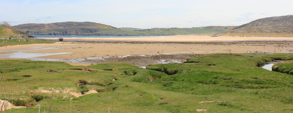
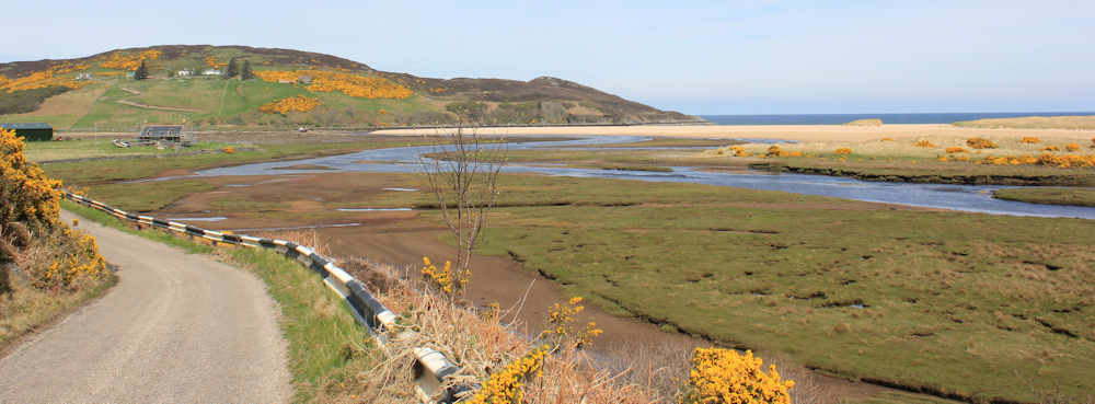
The tide is out. I’m walking around the edge of a large, sandy bay. Torrisdale Bay, says my map – which sounds kind of familiar. Where have I heard about this bay before? It’s not an area I know, at all.
Further along the road, I can see the mouth of the bay with open sea beyond. I really am walking along the coast again.

I leave the road and walk next to the shore, hoping I will be able to cross the beach to continue my coastal walk next to… well, next to the actual coast! But the sandy bay is intersected by a river and I find myself walking up the bank of an estuary.
This is the River Borgie. Maybe I can wade across? But the channels between the sandbanks look unnerving deep, and the current is flowing fast.

I head back to the road, which runs along the west side of the river, rising higher now above the water.
Stop to catch my breath and take a photo looking back at Torrisdale Bay. It really is beautiful. I can understand why the couple building their DIY house want to live here.
I cycled here this morning along the roads from a village called Bettyhill, an 8 mile ride across featureless moors. So I realise I might have to walk back along the road – which I was hoping to avoid. But there is still a chance I can cross the river… on the way here I noticed a path signpost and a map, while my ordinance survey map indicates a FB (aka a footbridge) somewhere below me.
Mind you, just because my OS map indicates a footbridge, it doesn’t mean that a bridge really exists. (I’ve discovered that maps in Scotland tend to be a triumph of optimism over reality.)
Ah, here is the signpost, next to a bench beside a car parking area. The map on display is a little disappointing. I was rather hoping it would show the local area around the bay, and the route of the path – but it turns out to be a large-scale road map, showing me how to get to Tongue. Not a lot of use to me.

The signpost is a not much help either. It tells me it is 4.3 km to Invernaver, but I have no idea where that is. However, it is only 800m to the beach.
Well, nothing to lose. I follow the path down the slope and into the river valley.
Yes, there really is a bridge here, despite my scepticism. It looks a bit rudimentary, but turns out to be surprisingly sturdy, as it crosses high over the river.

On the other side, somewhere, my OS map indicates there is a path that leads over the high ground to… to… oh, to Invernaver, where there is a road bridge over another river. From there, the road leads up to Bettyhill.
It turns out I haven’t quite finished crossing this river, which has split into a number of smaller streams on this side, and has also spread some water across the land to create a marsh. Luckily, there are a several smaller bridges to help me across the streams and to keep my feet dry in the swampy areas.

Finally, I reach the other side of the river valley, and follow the bank where there is a clear track, heading back towards the bay.

Over a ridge of sand dunes…
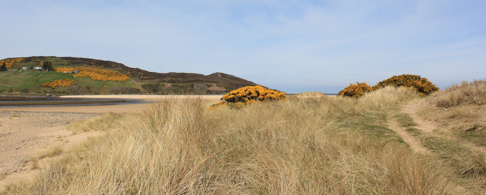
… and here is the beach of Torrisdale Bay. So large, I can barely see the sea in the distance. I feel like I’m standing on the edge of a huge desert.

I pull out my Garmin to check my route – only to discover the batteries have died! From now on, it’s just me and my paper OS map. I step out onto the sand.
[To be continued…]
Note: Torrisdale Bay sounded familiar because I had walked past another Torrisdale Bay, on the Mull of Kintyre.
Route so far:


Another nice walk in beautiful weather. I love the view in the third photo from the bottom and the one looking back at Torrisdale Bay is gorgeous.
It was such a lovely bay, and a surprise to discover it after a day of inland walking.
So beautiful, and the size of the beach is amazing.
A vast beach. But I imagine it looks very different with the tide in.
The curse of the dead battery. Can you download a map to your mobile such as Outdooractive or Alltrails? Just as a backup.
ray
A good idea, but I rarely run out of battery. I just forgot to recharge!
A lovely place for sure. If only it was 30 degrees it’d be like the Carribean!
I carry one of those battery backup things, like this:
It’s really good. In fact I keep my phone permanently plugged into it now when I’m walking.
Hmm, that didn’t work.. just search “Power Bank” in Amazon 😉
I will do. I do have an old power bank, which I used when iPhones had really short battery lives, but it no longer works. I need a new one.
I love the scent of gorse and the glowing colour of the little flowers. Torrisdale Bay is spectacular. definitely my kind of beach.
You did much better than I did. I managed to follow the wrong track after the footbridge and it took me a couple of goes to find the right way again.
Looks like you had lovely weather for it!