65. Warsash, Southampton to Hythe

Hamble - Warsash pink ferry shelter, Ruth's coastal walk.You can’t mistake the Hamble Ferry. It is coloured pink. Not a wishy-washy pastel pink. Bright pink.

There is no ferry waiting when I arrive on the east bank. But I know I am in the right place because there is a pink shelter and pink signs on the jetty. I wait. After a very short time, I see a pink boat making its way across the river, threading its way through moored sailing ships, to meet me.

Hamble-Warsash pink ferry, Ruth walks around the coast, Hampshire.The ferry is tiny and I think it is called Claire (there is another ferry-boat, slightly larger, called Elaine). The trip across the river takes 7 mins. I am the only passenger. The ‘captain’ is friendly but not a talking kind of man. I pay him the ridiculous fee of £1.00.

When we arrive on the west bank – at Hamble-le-Rice – a family is waiting to cross back towards Warsash. I watch them set off. Just as they leave the jetty, another couple of passengers arrive. The ferry turns back to pick them up.

Woods, Hamble-le-Rice, Ruth on her coastal walk, UK
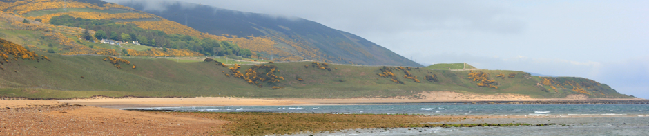
From Hamble-le-Rice I am unable to follow the bank of the river around towards Southampton Water, as my way is barred by a marina. I walk along a street and then take a footpath through a wooded area. This is Hamble Common. There are families, joggers, dog walkers – all enjoying this bank holiday Monday.

Through the woods, the landscape changes to inlets and pools, set amidst scrubby land. I walk along the edge of the water where, looking past moored ships, I can see the pink ferry shelter across the Hamble.

 Hamble-le-Rice Marina, Ruth on her coastal walk, River Hamble

Walk along Southampton Water, Ruth's coastal walkI cross a road and walk along the shoreline of Southampton Water. There is a proper path and there are plenty of people about. The day is sunny, although not very warm.

In the distance, across the water, I can still see the Isle of Wight and the sailing ships around Cowes.

Later, this scenic view gives way to the industrial landscape of Fawley, with its oil refinery and power station. And the path passes under a huge pipeline, stretching above my head and out along a jetty. To my right, on my side of the shore, I walk past high industrial fences. I love this juxtaposition of nature and civilisation.

Fawley oil refinery, across Southampton Water. Ruth walks around the coast.

Fawley through trees, Ruth walks around the coastline, HampshireThe path becomes wilder, winding up-and-down through trees. There is a steep bank down to the water on my left. To my right there is a road, I hear traffic passing along it, but no buildings visible.

At one point I come across an impromptu campsite. Three small tents are pitched on the path with their guy ropes stretching across my way. I have no choice but to climb over the ropes and walk past the tent entrances, where I glimpse sleepy young people looking out at me in apparent bewilderment through open flaps.

I wonder if they arrived here last night and did not realise they were camping on a public footpath.

Now I walk along the shore itself. The going is difficult – the path gives way to rough shingle – and there is nobody around except the occasional lone fisherman.

Ahead I see a large passenger liner ship. That must be Southampton Docks. As I draw nearer, I realise this is Queen Mary 2. It is huge.

Queen Mary in distance, Ruth walks along Southampton Water

I walk past a small sailing club and arrive at a point where I am forced to detour inland.

Royal Victoria Park, sign, Netley, Ruth walks the coast in HampshireRoyal Victoria Hospital, Netley, Ruth's coastal walk around the UKSuddenly, I am in parkland. There is a large, brick, building with a tower. I mistake it, initially, for a church. Families are running around on the green spaces, playing football, flying kites, setting up picnics. This is The Royal Victoria Country Park.

The ‘church’ turns out to be the old chapel of a former, large, military hospital – Netley Hospital – built in Queen Victoria’s time and actively used during the 1st World War. The original hospital was huge, with one of the longest corridors in the world.

Royal Victoria Country Park - view over Southampton Water, Ruth's coast walk

Below the old hospital chapel, there is a pleasant area of green space with large, mature trees, opening out to give a wonderful view across Southampton Water.

Netley - landing site for Queen Victoria, Ruths coastal walkWalking through the park, I emerge in Netley itself. The first thing I come across is a hard slipway. This was built to allow Queen Victoria to come ashore when she travelled across from her residence on the Isle of Wight to visit Netley and the hospital.

I sit on a bench and eat a snack, while contemplating the way forward. From here there is no walkway along the water and I am forced to follow the road through Netley.

On the other side of this detour, I find my way back to the shore again and walk along a firm promenade, heading for Southampton. This is a very pleasant walk – The Solent Way. The area has been newly renovated and, in front of me, is the slowly enlarging bulk of the Queen Mary.

approaching Southampton - Ruth's coastal walk - Queen Mary II in distance

long pier - mouth of the Itchen, Ruth walks around the coastJust as I turn inland, at the mouth of the River Itchen, I pass the end of a very long pier, stretching out into the mouth of the river with a T shaped end. It is open to the public and I am tempted to go along it. However, I think it is about 1/2 kilometre in length and time is pressing. I need to find a pub for lunch and arrange to meet my husband.

Alongside the pier, in rough grass by the water’s edge, I see a young man. He is stripped to the waste and is scooping water (I think) in cupped hands over his torso and hair. He takes out a comb and begins to comb his hair, very methodically, while remaining crouched over. He looks up and sees me. I am momentarily embarrassed and look away.

When I look back, he is still there, systematically combing through his hair. I wonder who he is and if he is living rough.

I walk along a road, heading towards the Itchen Bridge. This was opened in 1977, while I was at University in Southampton, and was a major feat of engineering. The road I walk along is grim, with one side fenced off and building works beyond, run-down houses and shops on the other. I think I can smell a sewerage works.

Then I see a cyclist coming towards me. My husband. There is a pub ahead. It does food.

What a pub! It looks like nothing has changed since the 70s. Sticky floor. Chipped tables. Stained chairs. And a man smoking in the bar. To be fair, he is the only customer and, seeing us, he moves outside to finish his cigarette. But the landlady is friendly and the food is cooked fresh to order and is very cheap – burgers and salad for me.

After lunch, I walk past newly built, smart apartments. They are just being populated and there are more buildings going up along the water’s side. I think of the tatty pub we have just left. It will need to change to attract the new people moving into the area. How will it survive? Should it survive?

Itchen Bridge, view to east bank, Ruth on her coastal walk

I am unable to take photos of the bridge. One minute I am walking through a building site, the next I am at the foot of the bridge itself. So, I have to content myself with taking photos of the view from the top. The photo above is of the east shore with the new buildings going up.

Itchen Bridge, view to west bank, Ruth on her coastal walk

The bridge soars above the water below. I take photos of the west bank, already populated with new buildings and a new marina beyond, at the mouth of the Itchin.

Itchen Bridge help point, on Ruth's coastal walkItchen bridge, Samaritan sign, Ruth walks around the coastOn the pedestrian approach to the bridge, I notice a sign advertising The Samaritans. On the bridge itself, there is a help point, where you can speak directly to somebody who will, presumably, attempt to talk you out of throwing yourself off.

As with Beachy Head before, I am disconcerted by the realisation that every high structure carries the risk of becoming a suicide site.

At the other end of the bridge, I am tempted to walk along the shoreline, along the walkways at the foot of the new buildings. But I am not sure if I will be able to get through. And I am growing tired. So, reluctantly, I decide to stick to the road and I follow signs for the docks and for the ferry port.

I pass the berth of the Queen Mary 2. Magnificent. Two young european men ask me to take their photograph with this impressive ship as a backdrop.

The Hythe Ferryis hard to find. I have to ask at the Red Funnel Ferry office. This is the place where you buy tickets for the Isle of Wight ferries. Where do I wait for the Hythe Ferry?

When I do find the right place, there is no ticket office, just ticket machines. As I pull out my coins, a man approaches me and asks if I need change. He is the Hythe Ferry ticket man but is, bizarrely, not allowed to sell tickets, only to hand out bags of change for the ticket machines. I exchange a fiver for a bag of change, buy my ticket and chat to the man while I wait.

We have to wait by an A board. I look down the walkway to the disembarkation point for the ferry. Framed in view, at the end of the walkway, is the Queen Mary. For one surreal moment, it looks like I am waiting to board this towering ship. (Afterwards, I wish I had taken a photo of this view.)

 Hythe Ferry arrives in Southampton, Ruth's coast walkHaving been first in the queue, quite a crowd collects by the time the ferry arrives. This is a popular route – used by tourists and by regular commuters alike. The alternative route across Southampton Water is by road and takes much longer.

Considering this, it is strange how poorly signed the Hythe Ferry is.

Southampton from the Hythe Ferry, Ruth's coastal walkLooking back, towards Southampton from the ferry, the city looks almost scenic. I spent five years living here as a medical student. I expected to feel some nostalgic attachment to the place. But I don’t. Maybe that’s because this dockland area, and the ferry, were not regular parts of my life when I lived here.

Hythe is not directly across the river. The ferry heads downstream to reach it. Looking back, I snap a final photo of the magnificent Queen Mary 2 and the industrial dockside of Southampton Water.

looking back to Southampton and Queen Mary, Ruth takes the ferry

We dock at the end of long pier. I had not expected this. The pier is the 7th longest pier in Britain. 700 yards long.

Hythe pier train, Hampshire, Ruth's coastal walk

A train track runs along the pier and I am tempted to take the little train. But that would be breaking my walking-round-the-coast rules!

Hythe pier and ferry, Ruth walks around the coast, HampshireHythe (hampshire) pier and Ruth on her coastal walkSo, I walk the 700 yards along the pier. Hythe looks lovely in the afternoon sunlight. And walking to meet me is my husband. He takes this photo.

Another fantastic day of walking through interesting and varied scenery!


vital stats:
Miles walked = 8
Ferry crossings made = 2
Bridge crossings = 1
High points = seeing Queen Mary 2 and crossing the Itchen Bridge
Low points = trying to find the embarkation point for Hythe Ferry

Route:

Posted in 07 Hampshire | Tagged , , , , | 3 Comments

64. Gosport to Warsash

It is a breezy Sunday and the weather forecaster warned it might rain. But I am in high spirits. There is an easy walk ahead of me.
lifeboat launch, Gosport, Stokes Bay, Ruth walks around the coast.

When my husband drops me off at the car park, there is great activity around the lifeboat station. It looks as though they are about to launch the lifeboat. I stay for a while and take photographs. But I can’t hang around. There is walking to be done.

Promenade - Stokes Bay, Gosport, Ruth's coast walk.D Day memorial, Stokes Bay, Gosport. Ruth walks around the coast. The promenade stretches along the coast, taking me towards Lee-on-the-Solent and Hill Head beyond, where I am meeting my husband for lunch.

Here I found a plaque to commemorate the Canadian embarkation.

This bay (Stokes Bay) is full of World War Two military history. The beach drops down into deep water and this area was used as a launch point for Canadian Troops during the D-Day landings.

Osborne House, Isle of Wight, Ruth walks around the coast of the UKAcross the water – The Solent – I can see the Isle of Wight and the unmistakable two towers of Osborne House, Queen Victoria’s seaside ‘cottage’.

[Warning! Non-photographers can stop reading now!]

I take this photograph using the Canon 18-55mm lens that came with the camera when I bought it. It has some telephoto zoom ability, but not much. You can tell from the quality of the photograph.

I resolve to buy a new telephoto lens. A better one. But a cheapish one. If I can find such a combination! And, maybe some filters. I think an ultraviolet filter would cut down the blue haze that obscures details and fades the colour in the distant shots. Also worth exploring is a polarizing filter, to cut down glare from the sea. Or perhaps a graduated neutral density filter, to enhance and darken the colour of the sky ….

[It’s OK, non-photographers – technical mumbo jumbo has stopped. You can start reading again!]

Browndown warning signs, Ruth walks around the coast of the UK, Hants.Browndown Military Training area, Ruth on her coastal walk, HampshireI come to an area of shingle beach called Browndown. This is a ‘Danger Area’ on my map. It used to be a military training area but is rarely used for such purposes now, it seems, and its main importance is as a nature reserve. Apparently, this patch of shingle hosts the incredibly rare Gilkicker Weevil.

I have learnt to respect and enjoy these areas of vegetated shingle, where unusual plants struggle to maintain a foothold in the inhospitable surface of dry, shifting, shingle stones. This unique habitat seems to represent both the extreme fragility and the incredible tenacity of life.

Isle of Wight, across shingle, Ruth on her coastal walk.

While walking across this stretch, I am passed by two men running. One of the men is lean and ‘fit’, in every sense of the word. The other is podgy and is sweating heavily. They stop ahead of me and begin running backwards, stumbling on the shingle. I realise one is a personal trainer. The other man is his pupil. It looks like hard work.

Browndown shingle banks, Ruth walks around the coast, through Hampshire.

Ahead is a shingle bank. The stones are a different colour to the beach and seems to have been constructed artificially and deliberately; maybe in an attempt to prevent erosion or to prevent flooding of the low heath land lying immediately behind the shingle.

The two men disappear up the bank. I don’t see them again.

rain coming, looking across across to Fawley, Ruth on her walk around the coast of the UK

I continue walking into Lee-on-the-Solent. The sky darkens and I see rain clouds in a band. The tiny sailing ships, close to the Isle of Wight, disappear in the grey of a distant downpour. Meanwhile, the chimneys and structures of the power station and oil refinery at Fawley are lit up by the sun’s rays, slanting beneath the dark clouds.

rain and jet skis, Ruth on her coastal walk, Lee-on-the-Solent Large drops fall on me. I have been so used to the threat of rain, but without any real drenching, I am taken unawares. Quickly I get out plastic bags and my rain jacket. My main concern is to protect my electronic equipment – my iPhone and my camera.

I find old-fashioned sea-side shelter and sit on a bench, waiting for the rain to pass. In the sea, jet skiers roar to and fro, undaunted by the rain.

When the rain lightens, I continue walking. This is a mistake. As soon as I am a distance from any shelter, the heavens open and huge drops thunder down. On the beach, people leap up and run in one of two direction – either to the their cars or straight into the sea.

I stop in the lee of an ice-cream van. My jacket is wet and, I realise, not very waterproof. The rain soaks straight through. This is miserable. Just when I want to abandon the walk, the sky lightens and the rain begins to ease off. In a few minutes it is dry. I am grateful for my light weight walking trousers – drying very quickly in the stiff breeze.

The promenade disappears and I walk across shingle with private gardens lining the beach. Just when I think the way ahead is barred, I see people walking around a distant wall and realise you can walk through. I reach Hill Head and walk up to the road to find the cafe where I meet my husband for lunch.

Hill Head, Hampshire, Ruth's coastal walk, UK

After lunch, I continue around the promenade and passed Hill Head Sailing Club and along the road bridge, across the mouth of Titchfield Haven.

Windsurfers and kiteboarders are arriving. The road gives them access to the beach. I watch them unpack their boards. But I can’t wait to see them launch. I have to keep walking…

private beach sign, near Hill Head, Ruth walks the coastline in Hampshire.Just beyond here, where the road turns inland, is a row of white, wooden huts. And a sign. ‘Private Beach’.

To me, this phrase is like a red rag to a bull. ‘Private Beach’! Huh!

I have joined The Ramblers recently. Not because I like rambling with others, but to add my weight to their ‘Claim the Coast’ campaign; to secure a coastal path around the coastline of England. Unfortunately, despite the fact that legislation has been passed to allow the path to happen, it would not seem to be a matter of priority in these difficult economic circumstances.

So, of course, I walk in front of the houses, along the shingle. (I have to confess this is difficult going, but I have to make a point, don’t I?) So does everybody else. People ignoring the signs, walking along the shore with their dogs and their families, enjoying the intermittent sunshine of this lovely day.

private beach, Hill Head, Ruth on her walk around the coast. Hampshire.

The next section of walk is lovely. On the map, no name is given to this part of the coastline, just the warning phrase ‘mud and sand’. In fact, there are low-lying cliffs (with erosion) and a narrow, empty, shingle beach. Later I learn the locals call this the Meon Shore, after the river Meon that empties into the sea at Titchfield Haven.

low cliffs, Fareham coastline, Ruth's coastal walk

I see a group of lady dog-walkers, with golden retrievers bouncing into the sea. The sun flits in and out of white clouds against a blue sky. Lovely.

holiday park slipway, Ruth walks the Hampshire CoastAfter a while I come across a slipway. A man with a kite is coming down the slipway – perhaps a bit faster than he intended. The wind is blowing strongly. The kite seems enormous. Then I realise. Ahhh. A kite surfer.

soft sand, Holiday Park at Chilling. Ruths coastal walkBeyond the slipway, the shingle turns to mud, so – after hesitating a little, but realising I am wearing soft shoes, not boots – I turn inland, walking through a holiday park. Actually, I walk around the internal perimeter of the park, trying to find a way along the coast. But am forced to leave the park along the vehicular access road, before I find a track leading back down to the shoreline.

Back on the sea wall, there are signs warning of mud. I am glad, despite the detour, that I didn’t try to walk along the shore to this point. It could have been very sticky. And, if I got stuck, highly embarrassing.

across River Hamble to refinery at Fawley, Ruth walks the coast through Hampshire

I come to an area called Hook Park, a nature reserve. Here, The Solent is about to merge into Southampton Water and the River Hamble empties into the sea. Across the water is Fawley Power Station and tall towers of Fawley Oil Refinery. Small, fragile sailing ships cross the water in front of this huge industrial scene, returning home to harbour. In the late afternoon sunlight, with the light coming through clouds from behind the chimneys and towers, there is something magical and surreal about the view.

I stop and take too many photographs.

fair weather sign, mouth of River Hamble, Ruth's coast walk

Somebody has written this warning graffiti on a piece of concrete wall, probably part of an old military fortification: ‘Fair weather a skilful sailor never made’. I suppose this is true.

Boats on River Hamble - Ruth on her walk around the coast, Hampshire

I turn inland, following the River Hamble, past an area where many ships are moored and past a long jetty. The tide is going out, exposing gleaming mud.

Now I am in Warsash. Here is a pretty harbour with a light house. I sit and have a snack, waiting for my husband to arrive to collect me. It has been a great day of walking.


Vital stats: miles walked = 10
Rain storms: two.

Just in case you are interested in vegetated shingle, here is some additional reading:
1. Natural England: MAR05-03-002 A Guide to the Management and Restoration of Coastal Vegetated Shingle.
2. Natural England: NECR054 Coastal Vegetated Shingle: Development of an evidence base of the extent and quality of shingle habitats in England to improve targeting and delivery of the coastal vegetated shingle HAP
3. DEFRA: Coastal Vegetated Shingle Structures of Great Britain

4. And, of course, links to my previous experiences: Dungeness and Bognor Regis.


Route:

Posted in 07 Hampshire | Tagged , , , , | 1 Comment

63. Portsmouth to Gosport

Beware big waves, Portsmouth beach, Ruth's coastal walk.I start where I left off last weekend, by the South Parade pier on Portsmouth’s shingle beach. There are signs warning of large waves created by ferries passing by. I feel nostalgic when I see the Isle of Wight ferry. I spent six months working as a surgical house officer in St Mary’s Hospital on the Island, many years ago.

This is a breezy bank holiday weekend and today turns out to be a fantastic day of walking, with a chance to try out my new camera. I take far too many photographs and so my blog of today’s walk will consist mainly of these photos.

(Having broken the autofocus on my old Olympus, I was keen to buy a new DSLR of the same make, so I could use the Olympus lenses. Unfortunately, I was unable to find a new DSLR Olympus for sale. I don’t know why. So, I have bought a Canon EOS 550D. The lens I am using is the basic 18-55mm one that came with the new camera.)

Portsmouth South Parade Pier, Ruth walks round the coastline.

After the pier, I walk past the new Pyramids Centre – a rather fine piece of architecture.

new development, Pyramids Centre, Portsmouth. Ruth walking round the coast.

lighthouse, Southsea Common, Ruth walks the coast through PortsmouthOn the southernmost tip of the beach stands Southsea Castle and the lighthouse, incorporated into the castle wall. The castle has been restored. The lighthouse is still functioning.

Beside the lighthouse, on a piece of green land called Southsea Common, is a bandstand. People are assembling at the bandstand and it looks as though some sort of concert is about to take place.

Memorial, Southsea Common, walking round the coast, through PortsmouthFurther on, I walk past Southsea Naval Memorial. This is a fine-looking memorial, flanked by lions and reminiscent of Trafalgar square.

kite flying, Southsea Common, Ruth's coastal walk through Portsmouth
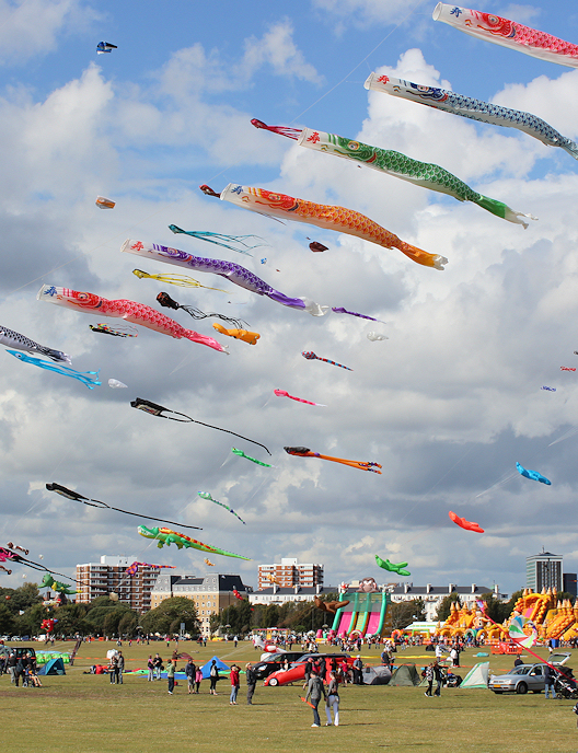
Southsea Common is awash with bright, floating kites and balloons. There is a fun fair and entertainments. Later, I find out that Portsmouth is hosting an International Kite Flying Festival this weekend.

Past the kites, I walk along Clarence Pier. This is the only ‘tacky’ part of the seafront I come across – with amusements, childrens’ rides and arcades.

Clarence Pier, Portsmouth. Ruth walks around the coast.

Beyond Clarence Pier is a renovated area where new sea walls have been constructed and creates a lovely walkway along the sea, overlooking a stretch of water on the landward side. This walk is part of the new Millennium Walkway through the old part of Portsmouth. A chain motif, etched into the paving slabs, provides a nice visual link to the sections of the walk.

Beyond Clarence Pier, the walk passes through the old part of Portsmouth – past the Square Tower and through the Round Tower.

Pubs in Old Portsmouth, on Ruths coast walk.This area of Portsmouth has been renovated very nicely – I barely recognise it from the grimmer, dilapidated Portsmouth I knew 35 years ago.

Now I come to an area I do recognise. Here are a couple of old, historic pubs and a cobbled street, where my husband and I came in our younger days, grateful to find one scenic spot in this city.

Looking at Wikipedia, I discover this area is called Portsmouth Point and there is an old coloured etching by Thomas Rowlandson showing how this same view might have looked in the late 18th Century.

Spinnaker Tower from Old Portsmouth, Ruth's coast walk.Just beyond the old pubs is a waterfront area that has undergone extensive renovation with new housing overlooking a small marina. Looming over the whole scene is the wonderful shape of the Spinnaker Tower.

The Millennium Walkway continues around the marina and into the new, commercial centre in which the Spinnaker Tower stands.

I have to confess that my husband and I visited the Spinnaker Tower and went up to the viewing platform this morning, before I started my walk today. Having looked forward to this for many weeks, I couldn’t wait! The photographs I took from the top are at the bottom of this blog.

By the time I reach this section of the walk, I am growing tired. I stumble around the shopping area for a while, trying to find my way through to the other side. Unfortunately, I continue following the Millennium Walkway markings, that don’t lead through. Eventually, I find the way out the other side and end up in Portsmouth Harbour.

Looking at the OS map, there is no easy way of walking round the Harbour area. Although there is a section of footpath along the northern part, most of the route around would involve road walking and some of the roads look very busy indeed. So I am pleased to have discovered a ‘Ferry P’ on the map, crossing the narrow channel at the mouth of the Harbour and taking me straight to Gosport.

The Gosport Ferry ride costs me £2.70 (I have to buy a return ticket – they don’t sell singles). This is a fantastic service with a crossing every 7.5 mins in peak times.

Spinnaker tower from Gosport ferry, Ruth's coastal walk through PortsmouthGosport Ferry looking back to Old Portsmouth, Ruth's coastal walkThe sun comes out for the crossing and I take advantage of the few brief minutes, before we dock at Gosport, to take some photographs of the Spinnaker Tower and Old Portsmouth from the ferry.

It is only after I have wandered around the deck for the whole trip, taking in the views, that I notice the signs telling me that passengers should remain seated at all times!

HMS Warrior, Portsmouth, from Gosport Ferry, Ruths coastal walk.I get a good view of HMS Warrior, a 19th Century steam and sailing warship. With an iron clad hull, and to defend us against possible French aggression, this was the largest ever ship to be built at the time.

This wonderful ship has been restored and is available for parties and weddings. In fact, my round-the-coast mentor – David Cotton – got married on this ship and instructed me say ‘hello’ to it.

When I get to Gosport, I find the harbour area is surprisingly attractive and stop to watch the ships go by. I can’t resist taking yet another photograph of the wonderful Spinnaker.

Gosport was an important military and naval centre. I discover it very much still is.

Spinnaker tower from Gosport, Ruth's coastal walk.

A footpath takes me past a marina, past a submarine (now a museum) and then along an extraordinarily boring road.

boring walk in Gosport - Ruth walks around the coastlineHospital, Gosport. Most boring walk. Ruth's coast walk. The road runs past a military area with high walls on either side and checkpoints on the side roads. I cannot get to the coast. The only thing of interest I see is a hospital sign alongside an impressive rectangular tower. (I believe this is part of The Royal Hospital Haslar, a naval hospital, now undergoing redevelopment.)

I am relieved to come to the end of the long, straight, boring road. Turning right, I walk past residential housing and then past a building surrounded by high fences. I believe this to be a prison, but later I discover it is Haslar Immigration Removal Centre.

Just past the Centre, through a car park, I catch a glimpse of the sea. But, after walking across the car park and finding myself on the shore, I am unable to walk any further as the way to the West is barred. It looks as if the barriers are shielding an old fortification. But there are no information signs in place. Later I find out this is Fort Monckton, an ancient fort but also MI6’s training HQ, according to The Times.

HM Prison, Gosport. Ruth's walk around the coast.

To my left I see a new building with high fences and I think this must be a new prison. But I can find no reference to a prison in this area – only to the detention centre. So what is this building? I don’t know.

Gilkicker, Gosport, Ruth's coastal walkA footpath leads from the road towards yet another fort, the 19th century Fort Gilkicker. The area around the fort has lakes and public access. The fort itself is closed off, although I see people walking around it.

Beyond the fort, I reach the coast. From an information board, I learn this area of the shore has deep water access and, as a result, could easily be invaded. It was also a great place to practice D-Day landings.

I stop to adjust my blister plaster. I am tired and glad my walk is about to come to an end. But I can’t resist taking one last photograph of the Portsmouth skyline, with The Spinnaker Tower, still visible across fields.

view back to Portsmouth, Ruth's coastal walk

Looking across the shingle beach and the waters of the Solent, silhouetted in the low evening sunshine, are the distant chimneys of Fawley Power Station and nearby oil refinery

view towards Hythe, Ruth's coastal walk

My husband John, Ruth's coastal walk - number one supporter I walk along the shingle, picking my way with care as my blister is really hurting on the uneven surface.

Ahead I see a lifeboat station and a car park alongside it. And there, waiting to meet me, is my husband.


Spinnaker Tower visit

Ruth up Spinnaker TowerHere are some of the photographs I took from the viewing platform on the Spinnaker Tower. I very much enjoyed my visit here. We both stripped off our shoes to walk across the glass floor – a vertigo inducing experience!

The weather today was perfect for photography with the sun shining but enough clouds to make the sky interesting. The only problem was (and I didn’t realise this at the time) that the glass was slightly tinted. This gave the photographs a blue cast and I had to manipulate them with my software to improve the colours. As a result, they have lost some of the depth and clarity of colour and definition.

view out to sea, Isle of Wight, from Spinnaker Tower, Portsmouth, Ruth's visit.

View into Portsmouth Harbour from Spinnaker Tower, Ruth's visit.

HMS warrior, from Spinnaker Tower in Portsmouth. Ruth's visit


Spinnaker Tower, Portsmouth - artists interpretation.

The Spinnaker Tower, Portsmouth. Tim Baynes captures the magnificence of this towering structure.

Artist in Residence
I asked Tim Baynes to use my Spinnaker Tower photos and to capture the essence of this wonderful structure. This is what he produced. I am sure you will agree it is a great piece of artwork and I love the way he incorporates the words from my blog into the painting.

To see more of Tim Baynes’ work, please visit Tim’s website or his blog Random Creativity.


Miles walked = 6.4
High point – the Spinnaker Tower of course!

Route:


Posted in 07 Hampshire | Tagged , , , , | 4 Comments

62. Langstone to Portsmouth

walk from Havant towards Portsmouth, Ruths coastal walk.I start off on a dull morning, walking along the road from the industrial estate in Langstone. The road crosses over a bridge and I see the footpath below. There seems no way to get down, until I realise I need to walk down an inclined cycle path on the opposite side of the road to pass under the bridge.

The swans are still swimming in front of the Tarmac works. Yesterday there were jet skiers here, launching from a slipway. Today, on this dull Sunday morning, there is nobody around except a few dog walkers.

warning sign - near sewage walks, Havant, Ruth's coastal walk.Just as I am thinking this looks like a good spot for informal messing about in boats, I see a sign warning that shellfish may be contaminated. I wonder if that is due to the nearby sewage works? The sewage smell is distant but still present.

The path is also a cycle way – called the Solent Way and leading towards Portsmouth. It follows the coast and is well maintained, although long, straight and somewhat boring. But not unpleasant.

I meet an old boy walking his little dog. Few other people get as far as this. I have noticed most dog walkers don’t stray more than 50 yards from their cars.

old man walking with dog, Solent Way, Ruth walks around the coast, Hampshire.

Looking back, I can see the path along which I walked yesterday and the distant outline of the bridge to Hayling Island.

I reach the A27 and, for a short while, the path runs beside it. Although I can hear the traffic roaring by, there is a wide hedge that separates walkers and cyclists from the busy road.

The A27, heading into Portsmouth. Ruth walks around the coast.

Japanese Knotweed warning sign, Portsmouth, Ruths coast walk.Close to the road, I come across two fenced off areas and warning signs for Japanese Knotweed. This is a new experience and I am surprised. I only have a vague idea about this plant but I know it is a menace – growing very rapidly and with no natural predators in the UK.

Later, I learn that Japanese Knotweed is controlled by law in the UK and it is illegal to grow it in your garden. It can grow through concrete and cause structural damage to buildings and to roads. Looking at my photographs again, I see no sign of it in the fenced off area. Hopefully it has been successfully eradicated.

Walking onwards, the path branches away from the road and runs around the edge of a triangle of boggy land, called Farlington Marshes, that sticks down into Langstone Harbour. Although I seem to have spent much of the past few walking days skirting around peninsulas of land, I am pleased to get away from the busy road.

The sky overhead is clear and the sun has started shining, so I am surprised when drops of rain begin to fall. I am on the edge of a band of rain cloud. I stow my camera and iPhone away. Luckily the rain does not come my way and I escape a drenching (my husband, cycling inland, is not so lucky).

rainbow over Havant, Ruth's coastal walk

A few minutes later I see this lovely rainbow over Havant.

View of Portsmouth across Langstone Harbour, Ruth walks around the UK coast.Approaching the tip of the peninsula, there are great views out across mud and water. Looking across Langstone Harbour I can see the cityscape of Portsmouth, including the unmistakable shape of the Spinnaker Tower – like a giant sewing-machine needle.

In the distance I see the tip of Hayling Island and the narrow gap between Hayling Island and Portsmouth itself (although I may imagine I can see this.)

I meet some joggers, a few walkers and a number of bird watchers. Everybody is friendly and says ‘hello’ as they pass.

birdwatcher on Farlington Marshes, Ruth walks around the coastline

Coming off the marsh area, I walk across a bridge onto Portsmouth. Although the road is very busy (this is the A2030), there is a wide walking and cycle lane across the bridge.

A2030 bridge into Portsmouth, Ruth's coastal walkPortsmouth is built on Portsea Island and is, technically speaking, an island. Therefore, according to my ‘rules’, I don’t need to walk around it. But I do want to see the new Spinnaker Tower and there is a good footpath shown on the map (the one I am following).

I know the old area of Portsmouth, Southsea and the old town, as I spent some weeks here on an attachment at St. Mary’s hospital when I was a medical student. So I am looking forward to seeing the city again but I am not expecting much. I remember a hectic town centre with brutal architecture and a neglected sea front.

walking into Portsmouth, Ruth on her coastal walk.

This part of the walk is surprisingly scenic with a view over the muddy harbour and sailing ships sitting in the mud. If the tide was in, the view would be even nicer.

Portsea Island, water sports centre - Ruth coast walk.I pass an activity centre. There is nobody around, but I see a collection of small sailing ships and bright kayaks. Alongside is a climbing wall. It looks like a fun place.

John with bike at pub - Ruth walks around the coast, PortsmouthThe path is concrete and I make good progress, arriving early at the pub where I plan to meet my husband for lunch. It is already filling up at 11:55 am. I am not the only early bird.

Upstairs there is a wooden balcony, where my husband parks his bike. We sit outside, overlooking the mud. The tide is coming in and as we eat we see the water steadily advancing nearer to the shore.

After lunch, I set off along the coast path. There are more people around now, out for Sunday strolls.

A long time ago, while at the hospital, I walked to the shore to see the sea. I remember walking across a derelict wasteland of scrub and wind-blown rubbish to the edge of the water. I stood on a rock and gazed over brown mud and grey water and wished I was somewhere on the other side of the ocean – somewhere warm and sunny.

I try to find the spot where I stood, but the area has been rejuvenated, with grassy banks and this lovely path. It is unrecognisable. And much nicer.

flags - memorial to fallen soldiers, Portsmouth, Ruths coastal walk.sign - memorial to fallen soldiers, Portsmouth, Ruths coastal walk.Further on, I come across this memorial, paying tribute to the service men and women who have lost their lives in recent conflicts. The memorial is not an official one. A couple of men sit nearby in folding chairs and I gather, from their proprietary air, they must have erected this.

Portsmouth is a naval city and many service people are based here. I wonder if there is an official memorial and, if not, why not.

looking over to Hayling Island, Ruth walks around the coast, Portsmouth.The path winds around the coast line, in and out. I pass pubs and cafes. I reach a spot where Hayling Island seems very close indeed and a hard path stretches out across the mud towards it.

I know there is a passenger ferry (a Ferry P on the OS map) across this narrow strait of water. I look to see if I can spot it. There are a great many ships out there, but I can’t see an obvious ferry.

Fierce swan, Portsmouth, Ruth's coast walkI walk around a bay where there are some new houses. The path is no longer clear. I am walking across shingle, sand and mud. I realise I am not on the official footpath, that passes inland of here, but I hope to find a way through around the shore line. I keep going.

I see a young woman ahead of me. She is hesitant to walk beside the water because of a group of swans. I pass close to them and take some photos. They watch me but they don’t move.

Frustratingly, I find myself in a newly built up area. The houses are very nice but block the way around the coastline. Beyond the houses is a marina – another block. I find myself walking down a road that leads to the Ferry P – but this is a dead-end. So I turn round and make my way past some old military structures before I can get access to the beach.

Now I walk along the south shore of Portsmouth. The beach is shingle and the going is not easy. I have a blister on the sole of my left foot, just below the base of my 2nd and 3rd toes; an odd place for a blister. I popped this yesterday, but it is starting to hurt again today and the shingle is making it worse.

South Portsmouth beach - group of people, Ruth walks around the coast

I see a group of people on the beach. They seem to be queuing up for turns on an inflatable ring, being pulled by a small motor boat. It looks like fun.

There are a few people swimming and some families on the edge of the sea – where there is a small strip of sand below the shingle and where children can dig with buckets and spades.

South Portsmouth beach - west indian group, Ruth's coast walk

Further on, I hear the sound of music. There is a large group of afro-carribean families. They are setting up a barbecue and have various tables laid with food and drink.

My foot is hurting and I decide to sit down and readjust my socks and blister plasters. I am surprised to find a memorial bench with knitted accessories.

knitted seat, Portsmouth, Ruths coastal walk

At first, I think this must be a tribute to an elderly lady who liked knitting. Then I realise the person to whom the seat is dedicated (Isobel Hunter Russel) only lived 6 months. Was it a child? Or a dog?

A nearby lamppost has a knitted cover too.

I approach the pier, where I am going to meet my husband and, realising I am early, I buy an ice-cream from a van – 99 flake, yummy. Sadly, before I start eating it, I drop the cone while putting my money away. A nearby white terrier looks very pleased. I am very disappointed.

Portsmouth South Parade Pier, Ruth's coastal walk


Miles walked = 10
Blisters = 1
Ice cream cones dropped = 1

Highlights: Farlington Marshes and the surprisingly nicely renovated seashore on the east side of Portsmouth.

Route:


Posted in 07 Hampshire | Tagged , , , , | 10 Comments

61. Prinsted, Thorney Island, Emsworth and Langstone

from Prinsted, towards Thorney Island, Ruths coastal walk, Chichester HarbourI start off from the waterfront at Prinsted, walking towards the Ministry of Defence owned peninsula of land, known as Thorney Island.

Access to the ‘Island’ is restricted but walkers are permitted. There is no vehicular access allowed and you can’t take a shortcut across country, so either you complete the whole peninsula walk (seven miles) or you have to turn back. There is an excellent description of the walk [pdf file] published by the MoD.

Thornham Marina, Thorney Island, Ruth's coastal walk.But before I reach the military area, I come across a marina and am forced off the coast while I detour around the boat yard. I find it amusing that the MoD allows access around its land but the marina does not.

Beyond the marina the walk continues and this stretch of path is well maintained. To my left is the wide, open expanse of Chichester Harbour with mud and water beyond. The sky is covered in clouds and the light is too dull for good photography. I am missing my DSLR Olympus camera, broken a few days ago when I dropped it on the hard floor at a pub. Today I am using my old Sony Cyber-shot.

Thorney Island, Ruth walks around the UK coastline.

After a long, straight stretch of path, I come to the military check point. Among the warning signs there is no indication that there is a right of way through here. It is a good job I did some research before this section of the work and I know that walkers are allowed through the gate.

MoD checkpoint, Thorney Island, Ruth's coastal walk.

There are no guards at the gate, just an intercom device with a button to press. I was warned I would need to give my name, address and mobile phone number. In preparation, I have even learnt my mobile number off by heart. So, I am slightly disappointed when, despite the fact I can hear people chatting over the intercom in a distant guard post, nobody asks me any questions or talks to me. There is a buzzing sound and the gate’s lock clanks open. I pass through.

MoD warning signs, Ruth walks around the coast, Thorney Island.

The path follows the shoreline and deviations are not permitted. I pass some bird watchers and meet a couple of walkers and some joggers. Later, as I progress towards the point of Thorney Island, I meet fewer people.

I walk past an old airfield runway and along a path lined with wonderful blackberry bushes, covered in juicy berries, where I spend some time enjoying a snack of fresh fruit.

The sky darkens and it begins to rain. I don my waterproof jacket and stow my camera and iPhone in plastic bags. Just as I finish weather-proofing my equipment, the rain stops.

Longmere Point is deserted. I don’t know how many people make the complete walk around Thorney Island, but on this dull Saturday I don’t meet any walkers as far along the path as this. There is an area of sandy dunes at the point and great views across Chichester Harbour to the open sea beyond the harbour mouth.

Chichester Harbour Mouth - from Longmere Point, Ruth walks round the coast.

I stop in a bird-hide and have a drink and a snack. Through binoculars I can see the area around West Wittering where I walked before, including the large house with the tall fences that so irritated me at the time. (I have to confess to a perverse sense of pleasure that the owner’s attempts to shield his house from sight are so easily circumvented with a decent pair of binoculars.)

The path winds through shrubs and bushes and I lose sight of the coast for a short period. Inland I see a group of people in a field, staring into the sky. For a moment I think they are clay pigeon shooting. Then I realise they are flying model aircraft.

Afghanistan death, memorial seat, Thorney Island, Ruth walks round the coastComing back to the shoreline, I find an area where there are two wooden seats with flowers and other memorial items. But, instead of bearing the names of elderly people, these benches are in memory of two young soldiers – Steven Jones killed in an air crash in Baghdad and Sean Reeve, killed in Afghanistan.

With daughters the same ages as these young men, I find this almost unbearably sad.

Later, I do some research about the young men and discover that Sean Reeve may not have lost his life if he had been travelling in a more robust landrover. Steven Jones may not have died if he had not been in a vulnerable Hercules aircraft. The Hercules had not been fitted with special safety foam and the coroner ruled he and his companions had been unlawfully killed due to serious failings by the RAF. What a waste.

In sombre mood, I continue walking on a raised bank along the west side of Thorney Island. I meet nobody. There is mud and sea to my left and ditches to my right. I startle a large bird (a marsh harrier, I think).

West side, Thorney Island, Ruth walks around the coast, Chichester Harbour.

After a period of time, I pass fresh water ponds on my right. This is The Great Deep. And I negotiate another set of security gates – again without having to talk to anybody, just buzzing the intercom and I am let through – to leave the MoD land behind.

towards Emsworth, Thorney Island, Ruth walks round Chichester Harbour.

A long straight path stretches ahead. For the first time since before the blackberry bushes I come across other walkers; a couple are hovering just on the other side of the MoD security gate. A man is walking with tripod and huge lenses, on the hunt for birds.

It is nearly 2pm and I am hungry and tired. Ahead I can see the buildings and sailing vessels of Emsworth Marina. There I meet my husband and we have lunch in the Deck Cafe overlooking the small harbour. The food and service are excellent.

Slipper Mill Pond, Ruth walks around the coast (2)Slipper Mill Pond, Ruth walks around the coast (1)From the marina, I walk into Emsworth and make my way around the Slipper Mill Pond. This is a lovely walk and I had no idea how beautiful Emsworth was, having never heard of the place before. It is well worth a visit.

In the middle of Slipper Mill Pond is a small island. It is covered in the black shapes of cormorants. Among the black figures is a lone, white egret.

cormorants on Slipper Mill Pond, Emsworth, Ruth's coastal walk

I wish I had my old camera with its zoom lens. Although the sun has finally appeared, the snaps taken by my Cyber-shot are of poor quality. I resolve to buy a new camera – soon!

high tide in Emsworth, Ruth tries to walk round the coast.My walk around the mill-pond has taken me inland. I walk through a housing estate to reach the shore again, but find my way is barred. The tide is in. The footpath is covered.

I curse inwardly and traipse along the town’s streets until I find my way back to the shoreline.

Now I am in a very scenic setting. The sun is shining. People are out enjoying the afternoon. The tide is in and ships are bobbing in the water. My bad temper quickly disappears.

Emsworth - Town Mill Pond Promenade, Ruth walks the coast.

A wide promenade leads from the shore. This is the Town Mill Pond Promenade (yes, Emsworth has two mill ponds) and it loops out into the water to form a large semicircle, joining the shore again further along.

I really enjoy this part of the walk. The promenade is lovely and the walk along the waterside (called both ‘The Wayfarer’s Walk’ and ‘Smugglers’ Way’, depending which map you look at) is wonderful. With the tide in, the walkway itself is very narrow.

13 Wayfarer's walk (view 1) Ruth's coastal walk, Emsworth.

I pass a jetty where small ships are being launched. There are children in the ships and adults shouting instructions from the shore side.

Wayfarer's walk (view 2) Ruth's coastal walk, Emsworth.

Further out to sea, races are taking place. Sailing boats are passing to and fro. I am not a sailor and, although I know there must be organisation behind it all, the scene looks chaotic to me.

Wayfarer's walk (view 3) Ruth's coastal walk, Emsworth.

Further on, I pass a small beach where families are enjoying the weekend and youngsters are messing about in boats. Another perfect English day.

The footpath leaves the shore (for no good reason that I can tell) and passes through fields. If the tide was low, you could continue round on the beach. But today it is covered in water. So I walk through a field of cows and then along the sea wall to a wooded area.

I realise this is one, enormous graveyard. There is a mixture of old graves and new graves. I sit on a seat in the graveyard to adjust a blister plaster and to unzip my lower trousers and convert them into shorts. As I do this, I realise I am sitting in section of the cemetery devoted to children; full of little graves with toys among the flower tributes.

Hayling Island and Langstone Hotel, Ruth's walk around the coast.

Leaving the cemetery behind, I walk towards Hayling island. This area is called Langstone Harbour. Ahead I see the tower of an old mill, while just across the water I see a large hotel building among trees. I have been told to watch out for this building as it was the venue of some friends’ wedding reception, many years ago.

Dutifully I take photographs, knowing that the quality will be poor.

Hayling Island is a real island and, therefore, I am excused from walking round it. I was tempted because I am told the Island is scenic, but I looked at the OS map and saw there is no footpath access to most of the shoreline (why, I don’t know). Since I don’t fancy spending a day walking on roads, I am sticking to the mainland.

From here, I can see the road bridge across the island. It is busy with traffic.

Hayling Island from East side, Ruth walks round coastline, Hampshire

Langstone Mill, Ruth's walk around the coastlineI walk past a pub and around the Langstone Mill. This is a listed building and has been converted to residential use. Apparently Nevil Shute stayed here for a few months, escaping the wartime bombing blitz on Portsmouth.

Later, I learn this area has a great literary heritage, having been home to Keats, P.G. Wodehouse, Kipling and Nevil Shute, among others.

I found this amazing photo of Langstone Mill, circa 1895, surrounded by ice floes.

I cross over the busy A3023 leading to Hayling Island. It takes me some time to find the footpath on the other side. I walk down a cycle lane and find myself back at the bridge. Frustrated, I retrace my footsteps and find a footpath sign that directs me through a newish housing estate. After a couple of wrong turns, I find the footpath leading westwards.

Hayling Island from west side, Ruth walking round the coast.

Initially, I pass a number of people out for a late-afternoon stroll. As I walk further, the people disappear. Looking back, I can see the bridge to Hayling Island, as viewed from this side.

Tired now, I find this section of the walk rather boring and hard going, as many sections consist of loose gravel. I am walking into the sun. Ahead, silhouetted against the bright sky, is Portsmouth. I can make out the Spinnaker Tower.

Portsmouth in distance, from Langstone Harbour, Ruths coast walk

I pass through an empty car park and the path winds along the shore, below a high bank. A familiar, and unpleasant, smell fills the air. Yes, there is a sewage works here – hidden behind the bank.

Tarmac works, Langstone, Ruth's coastal walkBy the sewage works is a creek. I follow the footpath up the creek, heading through an industrial area. Across the creek is an industrial complex belonging to Tarmac. In front of the industrial structures, incongruously, is a large group of beautiful swans.

The path runs alongside an electricity substation. I meet a couple picking blackberries. With the stench of the sewage works nearby, I am not sure I would want to pick blackberries here and I remember the wonderfully tasty berries I picked on Thorney Island.

The footpath ends in a road – a small industrial area. I wait for my husband to arrive in his car.


Miles walked = 13 miles
High points = discovering Emsworth
Low points = sad thoughts on wasted lives, Thorney Island
Resolutions: to buy a new DSLR camera a.s.a.p.

Later, when I look at the OS map to plan the next day’s walk, I realise I have crossed the county boundary and have left West Sussex behind. I am now in Hampshire. This crossing was unmarked and, therefore, unnoticed – and happened just as I left Emsworth Marina after lunch. Another milestone passed!

Route:


Posted in 06 Sussex, 07 Hampshire | Tagged , , , , | 3 Comments

60. Bosham to Prinsted, Southbourne

Fields, Eastfield Farm, Ruth walking round the coast, Sussex.It is the first Monday of the school summer holidays and I have taken the day off work. Today I am walking round a peninsula that protrudes down into Chichester Harbour, between Bosham and Thorney Island. On the map, this finger of land looks sparsely populated with one village called Chidham on its knuckle and a few houses clustered near the its tip.

My camera is broken, following the drop onto the hard floor of the pub yesterday. I am reduced to taking photos with my iPhone. I am not in the best of moods.

Sea wall near Chidham, Ruth's coastal walk through SussexI start off along a path that runs below the sea wall, on the landward side, walking through farmland.

Then, up on the sea wall itself, I walk along a narrow path. After a while, I am forced off the path by a housing estate on the outskirts of the village of Chidham. The houses are large. The gardens well-tended. Stern signs tell me to stick to the roadway through this area – walkers are only just tolerated and we must behave ourselves.

Towards Bosham, from Chidham, Ruth on her coast walk. Sussex.Finding a footpath to the sea wall again, I am relieved to be back on the coast. The tide is out and to my left I look across flat marsh and mud to Bosham, where I walked yesterday.

Further along and I am forced off the coast again. This time, by a private marina. I wander around a track that leads behind the boat yard and around some buildings. Between gaps in fencing, I notice a group of youngsters gathered around an instructor. I believe this is Cobnor Activities Centre.

Momentarily I become lost. I ask some people where the footpath is, but they are visitors to the Centre and they don’t know. Then I see a man with a rucksack, walking purposefully, and I follow him.

Private marina area, Ruth walks around the coast through Sussex.At the far end of the Centre, I am allowed back on the sea wall again. This area is a nature reserve and some effort has been put into making pools of water just inland of the shore – The Cobnor Point Habitat Creation Scheme – particularly designed to encourage water voles. I watch out for these little creatures, but I don’t see any.

This part of the walk has been designed to allow wheelchair access. I meet a few other walkers, but non in a wheelchair. Across the mud and the water, I can see West Itchenor and the narrow channel of water across which I rode in the Ferry P yesterday.

After a while, as I round Cobnor Point, the path narrows again and I walk on the shore itself, just below the sea wall. It looks as if this path is just above the high tide mark but may become flooded at times.

Oak trees overhanging coastal walk, Chichester Harbour, Ruth's coastal walk.

Overhanging the sea wall are oak trees. They are very close to the shore and I walk on the shore beneath their overhanging branches. I wonder how they survive. Are their roots bathed in salt water when the tide comes in?

At this point I pass a couple of walkers, husband and wife I presume, walking towards me. They have walking sticks and look tired, picking their way over the stones along the shore path. I suspect they are walking round the whole of this peninsular, as I am, but in the opposite direction.

Path along sea wall with flowers, Chidham Point, Ruth's coast walk. SussexFrom here on, I see nobody else until I get closer to Prinsted.

Back up on the sea wall now and this part of the walk is very pretty. There are wild flowers along the path. To my right, inland, I see glimpses of the private grounds of a fine house. This gives way to waterways with fields beyond. The country side is empty of people and very tranquil.

Path along sea wall, towards Prinsted, Ruth walks the coast in Sussex.I follow the sea wall. The sun is shining. There is very little breeze. It is growing hot and I am hungry for lunch. There is no vehicle access to this side of the peninsula and I have no choice but to continue walking until I reach the ‘mainland’ again.

I walk around Chidham Point. Nearly there now.

At the top of the peninsula, just south of Nutbourne, I begin to see walkers – people out with their dogs and children. A few families are sitting on the shore, on the edge of the mud, picnicking. The adults sit sunbathing on the stones of the sea wall, while the children grub around in the wet marshland.

View towards Thorney Island, Ruth's coast walk.In the distance I see a marina with sailing boats moored in the channel of water and I realise I am looking at Thorney Island. A spit of mud, looking like a causeway, leads out towards the water. For a moment I am tempted to walk along it. Surely I can cross over here? But a look at my map dissuades me. There is no way across the mud.

Eventually, I arrive at a car park. This is Prinsted, part of Southbourne. It is time for a late lunch.

My husband and I drive to Rowlands Castle, where we sit outside at a pub and eat a good meal in the sunshine. We savour a rare Monday morning off work together. Next to us, a table of teachers, with a whole six weeks of holiday ahead of them, sit and moan about how hard they work. Am I sympathetic? No!


Vital stats:
Distance walked = 7 miles,
Horizontal distance travelled = 2 miles.

Route:


Posted in 06 Sussex | Tagged , , , , | 4 Comments

59. East Wittering to Bosham

Beach, East Wittering, Ruth walking round the coast in Sussex.The sun is shining on this Sunday morning. My walk begins where it ended yesterday, from Bracklesham car park. I was not looking forward to resuming my fight with the shingle. But I needn’t have worried.

The tide is low and I stumble down the loose shingle bank to where I can walk on wonderful, firm sand – smooth and still glistening wet from the receding waves. There are no other people out yet and my footprints are the first marks on the virgin surface. I don’t know why it is so wonderful to make the first footprints on a beach. But it is.

There are long breakwaters stretching down the beach. Sometimes I can walk around their lower ends. Sometimes I have to climb through them. I don’t mind. Sand. Glorious Sand.

As the morning progresses, people begin to appear. Looking eastwards, squinting into the morning sunlight, I see Selsey Bill and the distant look-out tower, where I walked yesterday. Cormorants are perching on the warning markers at the end of the groynes.
figures on East Wittering beach, Ruth's coastal walk.

Walking along through East Wittering, dog walkers appear and I see a cyclist wobbling towards me along the beach. His progress is interrupted by a groyne and he turns back.

Cyclist on the beach, East Wittering, Ruth walking round the coast.

Further on I come across a family constructing a maze. A circular pattern has been marked out on the sand and people are scooping shingle up with buckets and then ‘pouring’ it along the lines of the maze.

Constructing a maze on the beach, Ruth's coastal walk.

Higher up the beach, a girl on a large horse passes me, trotting eastwards. Later, I see her again, cantering back, this time along the edge of the waves.

Horse riding on the beach, East Wittering, Ruth's coastal walk.

There is a mass of land out to sea – I can see white cliffs with high land beyond. I am pretty sure this is Bembridge on the Isle of Wight. Bright sailing boats pass to and fro in the water.

view across to Portsmouth, Ruth walking round the coast, Sussex.Ahead, I can see a cityscape, hazy in the distance. There is an unusual structure, towering above the other high-rise buildings. I recognise this – it is Portsmouth’s Spinnaker Tower. I would very much like to visit this amazing building. It has panoramic views and a glass floor to the viewing gallery – not for the faint hearted!

I have passed through East Wittering and am now walking across a wide, sunny stretch of beach. People are everywhere – sitting on the sand, erecting windbreaks, riding bikes, building sand castles, running down to the water, paddling and swimming. It is a beautiful day and I revel in the scene – this is the first weekend of the school holidays and an absolutely perfect English summer’s day.

walker with dog, East Wittering, Sussex. Ruth walking round the coast.serious walker, East Wittering, on Ruth's walk round the coastAmong all the holiday makers, I see a couple of serious walkers striding across the beach. One man has a huge rucksack and looks like the sort of person who would cover 20-30 miles a day. The other has some interesting floral shorts and very muscular legs (maybe he is a cyclist too), with a dog in tow.

With over a year of walking behind me, I feel almost like a professional walker these days. But I still travel very light – with my small green rucksack. Today I am wearing ordinary trainers, not walking boots. Compared to these guys, I am an amateur.

This beach seems to go on for ever. Having curved around, I no longer see Portsmouth ahead but, instead, see a creek with small sailing ships. That must be Hayling Island.

looking across to Hayling Island, West Sussex, Ruth walks the coast

Then something odd happens. A group of white-clad children appear at the top of the beach and run down, shrieking, towards the sea. I think they are wearing pyjamas. How very odd. The children don’t stop at the water’s edge but run, splashing, into the sea. The shrieking is even louder now. Adults, also in white pyjamas, run after them, shouting at them to stop.

Eventually, the children are retrieved from the water. They all line up on the sand, facing two of the adults, bow to each other and kneel down. I realise it is a martial arts group. Maybe judo. Or karate.

Martial Arts school on the beach, East Head, Sussex. Ruth's coast walk.

Just when it appears that order is restored, the lineup is disrupted by an excitable dog, who bounces into the group and prances around among the children. A man, shouting ineffectually, runs into the line up and chases the dog. Everybody gets tangled up in this game of tag, until the dog is eventually caught and dragged, reluctant, away from the children.

At the end of the beach, a long finger of dunes pokes into the estuary. This shifting mass of sand is called East Head and belongs to the National Trust. In today’s sunlight, against the blue sea, it looks beautiful. There is a car park near by. People are arriving. Barbeques are being lit. Picnics are in progress. Everybody is having fun.

East Head, West Sussex. Ruth's coastal walk around the UK.

I decide not to walk to the end of the dunes. Time is pressing. Instead, I walk across to the landward side. Here there is an area of salt marsh and I pick up the footpath that leads along the shore line towards West Itchenor.

This part of the walk is lovely. I walk across flower filled meadows, through wooded areas and by the side of an area of wide mud. The only downside is the sheer number of walkers I meet. Some people are on cycles (despite the fact cycling is not really allowed).

Chichester Harbour - wild flowers, Ruth's coastal walk.Chichester Harbour - mud, Ruth's coastal walk.

I look over Chichester Harbour – a wide bay with many estuaries, mainly mud except at high tide, but with deeper channels where sailing ships pass to and fro. There are lots of small dinghies out today and races are going on.

I pass through a small village called Rookwood – a hamlet really, just a few houses. The path deviates from the shore because of private property. Then, back on the shoreline again, passes along the bottom of gardens belonging to very fine houses.

high fences, Rookwood, West Sussex, Ruth on her coastal walk.Suddenly, the path is forced between two high fences. The fences are cleverly constructed so that the gaps between the wooden slats are covered by a second layer of internal slats. The wood is new. I feel constrained and somewhat claustrophobic in this narrow space.

2/3rds of the way along, I come across a pair of gates – one on each side, so the owner of the property can pass through his high fences and cross the footpath. Through holes for the locks, I can see what lies on the other side of both fences. To the seaward side, is a hard dock area with some boat launching equipment.

Hidden House, Rookwood, West Sussex,On the landward side is a very nice house. It looks new. It’s huge. And the owners obviously feel that those of us who use this footpath should not be allowed to get any view of any part of their property.

Because these high fences make me feel very indignant, I couldn’t resist taking a photo of the very thing the owner was trying to hide. Here is a view of this lovely house, taken through the hole where bolt is fitted in the gate.

I know landowners don’t like the idea of footpaths through their gardens. But the other properties along here, equally grand, take a more relaxed approach. So, to whoever put these fences up and ruined this section of the footpath, shame on you.

West Itchenor quay, Ruth's coastal walk, West Sussex.

The footpath goes leads into West Itchenor, where I meet my husband for a very nice lunch at the pub.

Then, I walk down to the quay and out onto a jetty, where the map shows a Ferry P (a passenger ferry) crosses over the water to the hard at Smugglers Lane, Bosham. Although I could walk around the estuary from here – it runs in a long finger up towards Chichester – I have decided to avoid this unnecessary detour. In any case, I love catching local ferries.

Ferry P, West Itchenor, Ruth on her coastal walk.The ferry is a perfect little minature ferry-boat and can take bicycles as well as passengers.

The journey across the narrow channel should only take a few minutes but takes a little longer. Partly because we have to weave in and out of moored boats and moving sailing ships, and partly because we deviate to drop people off at their boats. First a man, who jumps out the back of the ferry and into his rubber dinghy, taking the rest of us by surprise because we weren’t expecting it. Then a father with his three children scramble off the ferry and onto their sailing boat. The children are young (aged between 5 and 10), wear life jackets, and seem remarkably at ease leaping from one craft to another.

Ferry P, West Itchenor, Sussex. Ruth walking round the coast.As we approach the hard at Smugglers Lane, we see a group of people – walkers and cyclists – waiting for the ferry to arrive. There is a hard pathway through the soft mud, leading to the ferry embarkation point.

The Itchenor Ferry has run since the 17th century and operated 24 hours a day until the 1960s, when the ferryman applied to the House of Lords to allow the ferry to stop running. A seasonal service (summertime only) was reinstated in 1976.

approaching Bosham, Ruths coastal walk.From the hard, I walk along the shoreline, following the footpath. This is another lovely walk, through wooded areas and along grassy banks, less crowded than the walk to West Itchenor.

I round a bend and see Bosham ahead. This is a very pretty village. I have friends who live here and decide to drop in and see them.

Not used to arriving by foot and from this direction, I am a little disoriented and wander around until I find their driveway. They aren’t here. The house is shut up.

Bosham church, Ruth walks round the coast, East SussexDisappointed, I head into the main village. I walk along a road that floods at high tide. The tide is coming in, but has yet to reach the tarmac.

I stop at a cafe. My heart is set on tea and cake. Unfortunately, half the population of West Sussex seem to have the same idea and there are no seats. Next, I find a pub. Yes, they do tea and cake. And they have a lovely little balcony overlooking the water. Unfortunately, I drop my camera on the hard floor in the bar and jam the focus. I don’t realise this until later.

On the balcony, in the sunshine, I sit and enjoy a good cup of tea, watching the tide come in. Then I realise I may get cut off. Will the footpath be passable at high tide? I don’t know.

Bosham, incoming tide, Ruth's coastal walk, through West Sussex.I leave the pub in a hurry. People have put chairs out on the shore and there are still cars parked on the low-lying roadway. The tide is coming in at a pace, you can see the water growing closer to the tarmac. I wonder if the visitors realise and move their cars in time.

15 Bosham, looking back, Ruth's coastal walk, Sussex.I walk through Bosham and set off along the footpath. It runs around the bottom of gardens, below the walls. From the deposits of seaweed above the path, I realise the path is below the high tide line. I keep an anxious eye on the sea, creeping closer.

I leave Bosham behind and see the ‘mainland’ ahead. I would have really enjoyed this part of the walk, apart from my fear of the tide coming in and flooding the path.

I reach the end of the footpath, still dry. Now I walk through a field to the road. On the other side, according to the map, there is a track leading up to a lane and this is where I have arranged to meet my husband.

But I can’t see the track. How strange.

Then I see a man walking his dog. He turns off the road, walking through long grass. I follow him and find the track. It is an old road, now disused. Tall grass has grown up on the verges and hidden the tarmac. At the top of the road is my husband, waiting patiently.


This was a fantastic walk – beautiful weather and varied scenery. A great day! I believe, when the tide is high, sections of the footpath become covered in water. If you are planning this walk, make sure you know the time of high tide.

Miles walked = 11
High points = Beach walking to East Head and Ferry P at West Itchenor
Low points = breaking my camera

Route:

Posted in 06 Sussex | Tagged , , , , , | 6 Comments

58. Pagham to Selsey Bill to East Wittering

Entrance gate, Pagham Harbour, Ruth's coastal walk.Despite its name, Pagham Harbour is no longer a place where boats come, the entrance to the harbour having silted up years ago. (In fact, I don’t see a single dinghy, yacht or ship of any sort during this stage of my journey today.)

After the death of the harbour, the land was reclaimed as agricultural land in the 19th Century. Then, during a violent storm in 1910, the unforgiving sea broke through the banks and claimed it back. Now this area is an important Nature Reserve.

From here to Selsey Bill is only 3 miles as the crow flies. Of course, not being a crow, my route is much longer. Unable to walk across Pagham Harbour – on account of acres of mud, creeks and rivulets – I am walking around the circumference of this wide area of marshes and mud flats.

Egret and Swan, Pagham Harbour, Ruth's coastal walk. Sussex.The sun is shining and the day is beautiful. At the entrance to the Pagham Harbour, I stop and take photographs of a group of white water birds. There is a swan grooming itself in the sunlight and, close by, a beautiful little egret strides around, busily darting its neck in and out of the water.

Oyster Catcher in Pagham Harbour, Sussex. Ruth on her walk round the coast.Beyond are ducks and some birds with over-large heads wading in the mud. Ah, I recognise these birds – oyster catchers. They seem a little different from the oyster catchers I met on the Chetney Marshes in Kent. Their beaks are paler – not such a bright orange. I wonder if their diet is different here and this has affected their colouration.

Heron in Pagham Harbour, Sussex. Ruth on her walk round the coast.Heron in Pagham Harbour, Sussex. Ruth on her walk round the coast.Heron in Pagham Harbour, Sussex. Ruth on her walk round the coast.Then I see a large bird, dirty grey in colour compared to the brilliant white of the egret and swan. It wades through the water, close to the swan, keeping a careful eye on the water, looking for breakfast. It is a heron. I have never seen one so close up before.

I leave the little creek behind and head into the marshes. I overtake an elderly couple of bird watchers. He has a huge camera with an enormous lens around his neck. She has a tiny pair of binoculars. I ask them if they have seen anything interesting.

‘Not much happening,’ they tell me.
‘There are oyster catchers, swans, an egret and a heron back there,’ I tell them.
‘Oh yes,’ they say, dismissively. ‘Those are all very common here.’

Dead trees in Pagham marsh, Ruth on her coastal walk, Sussex.Path across Pagham harbour, Ruth walks round the coast, SussexThere are a number of paths to choose from, and I stick to the route that takes me closest to the distant sea.

The footpath looks well maintained and I am falsely reassured by the paving slabs and wooden steps over the muddy areas.

Luckily the tide is out, or I could have been defeated by mud and water. I find myself wading through mud and stumbling over uneven, tussocks of grass in the marsh. It seems the sea is gradually reclaiming this area, taking over the ancient footpaths and drowning the trees.

At one point, while slipping a sliding along a muddy section of path, I see debris on the marshy grass around me. I recognise this; here are the tiny carcasses of little white crabs, just as I saw on The Strood, Mersea Island.

07 Dead crabs, Pagham Marshes, Ruth walks the Sussex coast.

It is the tide that washed them up here. I wonder if they were dead on arrival or died later, stranded on the unfamiliar territory, unable to find their way back to the sea?

I come to an area called Sidlesham Quay. There are a collection of houses and a road winding round the apex of the marsh. Here there used to be an old tidal mill. The inland pond (where sea water was stored when the tide came in) is visible on the other side of the road. When the harbour silted up and the land was reclaimed as agricultural land, the tidal mill died. Only some ruins remain, stranded in the mud.
Remains of Tidal Mills, Sidlesham Quay, Ruth's walk through Sussex
I wonder about the feasibility of resurrecting some of these mills, in this age where we are looking for ‘green’ energy sources. We have built huge off shore wind mills to generate electricity. What about harnessing the power of the tide?

I walk around Sidlesham Quay and rejoin a foot path, taking me along the western side of Pagham Harbour reserve. I pass two ladies, sitting on a bench, painting the scene in watercolour on long, horizontal strips of paper. The sun is warm and the paint is drying too quickly. I stop and chat to them. They tell me there is a way straight across the marsh at low tide. But they don’t know the exact route.

Sidlesham Quay, Pagham Harbour, Ruth's walk through Sussex

From the footpath, I take photographs of Sidlesham Quay, looking very attractive in the sunshine.

view across Pagham Harbour, Ruth walks around the coast.I walk on a raised bank, skirting the edges of the marshy land. The sky is clouding over and the sunlight drifts across the flat landscape. In the distance I can see the sea wall that stretches across the old entrance to the old harbour. Path with flowers, Pagham Bay, on Ruth's coastal walk through SussexI am growing tired of mud and grass and look forward to seeing the sea again.

Later, I walk through an area where the path is surrounded by tall grasses, wild flowers and blackberry bushes.

Suddenly, I notice, there are butterflies everywhere. And big, fat bumble bees. I spend far too long on this section of the walk, taking photographs.

butterfly, on Ruth's coastal walk through Sussex11 bee, on Ruth's coastal walk through Sussexbutterfly, on Ruth's coastal walk through Sussex

Photographing butterflies is immensely frustrating. Just as you line up a perfect shot – in focus, sun out, no grass stalks in the way – the damn things flit off. But I am pleased that I do manage some good shots.

The path becomes more overgrown and overhung with oak trees. I am surprised to see such large trees with their roots close to salty marshes. I wonder if they will survive.

I meet a man pushing a bicycle along the overgrown path. He has telescopic equipment hung around his neck. He warns me ‘it is a jungle’ ahead. I grow worried that I won’t be able to get back to the shore. We stop and chat. He is a very enthusiastic bird watcher and travels all over the place to pursue his hobby. I ask him how far it is to Selsey Bill, but he seems unsure of where this is.

But I needn’t have worried. I turn a corner, cross an area of flat marshes, climb up a bank and find myself looking out over a long shingle beach.

Shingle beach, looking back towards Bognor, Ruth's coastal walk.

To my left, I can see back to Bognor. The break in the shoreline is hidden, giving the illusion you could walk, uninterrupted, along the beach. I am now only a mile away from yesterday’s finishing point. I was planning to walk, eastwards, along the beach, to the mouth of the Harbour. But the beach consists of rough shingle and I am both tired and behind schedule.

So I turn right and begin walking towards Selsey. Selsey Bill is the triangle of land you can see jutting down, clearly visible on the weather maps. I am looking forward to arriving here. It seems an important landmark on my walk.

I see more people about, walking and fishing. I would like to walk beside the water’s edge, but the shingle is too difficult and I follow a track along the top of the beach. At one point, the track becomes a ‘private road’. Houses have gardens that stretch across the road and encroach on the shore – private areas of lawn, fenced off with ‘keep off’ signs.

Blue plaque for 'Sleepy Lagoon', Ruth's coastal walk. Selsey.Then I meet the beginning of Selsey’s promenade. And here is a blue plaque and I learn that By the Sleepy Lagoon, the famous theme tune to Desert Island Discs, was inspired by the view across the bay.

The sky has clouded over completely and the light is dull, so the view does not look too appealing today.

The walkway along Selsey shore is narrow and crowded. People are out, walking dogs and with push chairs. Some are in mobility scooters. I find it difficult to adjust to the crowds after my morning of isolated walking.

There is a collection of fishing boats on the shingle and places where you can buy fresh sea food.

Selsey promenade - Ruth's coastal walk through Sussex.

Selsey Bill lifeboat station - Ruth's coastal walk through Sussex.

Further along, I see a structure I believe to be a pleasure pier. But as I draw nearer , I realise it is a pier for a life boat station. Presumably, in low tide, the pier is necessary for the launch of the boat.

Scuba divers, Selsey Bill. Ruth walks around the coastline.At the foot of the pier, people in scuba diving gear are assembling. They are getting dressed, pulling on their body suits and adjusting equipment. I wonder what they are up to. Is it a lesson? Or a communal dive? Or a special expedition of some sort?

Keep out sign, Selsey Bill. Ruth tries to walk along the coast.As I near the tip of Selsey Bill, I come across an obstruction to the path – a private house. The tide is high and waves are splashing up around the concrete skirt of the bottom of the property. Maybe, if the tide was out, you could walk around. But now I have no choice. I turn inland and walk through a park area, missing out the tip of Selsey Bill, before arriving back on the shore. I am now on the west side of the triangle.

After a brief stop for lunch (and there are not many pubs or eating places in this area), I continue my walk, heading for East Wittering. Again, I am unable to follow the shore – there is no walkway and the sea is up to the sea wall itself. So, I walk through streets.

Look out tower, Selsey Bill. Ruth walks the coast.Towards Holiday Village, Selsey, Ruth's coast walkI rejoin the coast at the end of a road. Here there is a tall look-out tower. I guess it is connected to the lifeboat station on the east side of Selsey Bill.

The sky is dark ahead. Heavy clouds threaten rain. I walk along the shore, grateful for patches of firm sand among the shingle, trying to speed up.

There is a holiday park ahead with a plantation of static caravans. The sea wall is being eroded and the path along the top of the wall has become too dangerous and is closed. Some of the caravans nearest to the sea look weather-beaten and have boarded up windows. I walk along the road through the holiday park, past a complex of buildings with fluttering flags.

On the other side of the holiday park, the shingle beach stretches ahead towards Bracklesham and East Wittering. There are fishermen on the shingle and people out walking dogs.

Selsey, fishermen, on Ruth's coastal walk, Sussex.

I meet a younger woman (late 30s, maybe) with an energetic dog. She tells me she has come here to escape from her family. The dog is a new acquisition. She talks non-stop for about 10 minutes. As a result, I could tell you lots of personal things about her and her intimate family relationships, but I won’t.

Walking towards East Wittering and Bracklesham, on Ruth's coastal walk, Sussex.Now I walk for miles along a high shingle bank, with dark sea on my left and flat marsh on my right. The going is difficult. I slip and slide on shingle, hunting for stretches where the stones are packed down. There are few features to break the monotony of the walk. I have the illusion I am walking on an endless treadmill of stones. A distant piece of driftwood (a rare sight on this beach) appears of monumental importance as a landmark.

I have plenty of time to think. I wonder if the shingle will ever end. I wonder why I am doing this. I think about the woman I have just left. (The amount of private information she offloaded within a few brief minutes, suggests she was either desperately lonely or hypomanic.)

It is a relief to reach Bracklesham. But also a disappointment. There are private houses backing onto the beach, but no promenade or footpath. Then shingle beach becomes steeper. The stones on the bank become looser and harder to negotiate. I am very tired and slide down the shingle bank to walk near the waves. This was a mistake, the shingle here is even deeper and more tiring than on the bank.

Seeing a carpark ahead, I leave the beach and text my husband. Am I in East Wittering? No, I am in Bracklesham. Don’t I want to walk another mile and meet at the East Wittering car park? No. I don’t. I’ve had enough.


Miles walked = 11 miles

High points = Sidlesham Quay, birds and butterflies
Low points = Selsey Bill and endless shingle

Route:


Posted in 06 Sussex | Tagged , , , , , | 18 Comments

57. Littlehampton to Bognor Regis and Pagham

A long weekend, with four great days of walking, stretches before me. It is midday on Friday when I arrive at Littlehampton’s East Beach and my plan is to walk into Bognor Regis for a late lunch.

01 From Atherington to Middleton-on-Sea, Sussex. Ruth's coast walk.

The tide is coming in and much of the sand is covered. I walk along the top of the beach, over packed-down shingle, around the top of groynes. As I start this walk, to my right are fields and open countryside. As I approach Middleton-on-Sea and, later, Bognor Regis, more and more houses appear.

1 - distant view Isle of Wight, Sussex. Ruth's coastal walk.

In the distance, I can make out a finger of low-lying land, extending out into the sea. That must be Selsey Bill. Beyond this low land, I can see a higher cliff. Is that towards Portsmouth, I wonder? I didn’t think there were cliffs ahead. Strange. Perhaps my eyes are playing tricks on me.

2 - Looking back to Littlehampton, breakwaters. Ruth on coast walk through Sussex.

I come to an area of beach where artificial breakwaters – large rocks – have been formed to protect the shore from erosion. Between the gaps in the breakwaters, small semi-circular ‘coves’ have been formed. I am reminded of the first time I saw similar breakwater reefs, back in Sea Palling, Norfolk.

I perch on one of the breakwaters and have a drink and a snack. The tide is still coming in and I am surprised to see how quickly the water begins to swirl around the base of the breakwater. I realise I am in danger of being stranded and quickly climb down off the rocks and head back up to the top of the beach.

4 - Egret on beach - Sussex, Ruth's coastal walk.4- egret in flight, Sussex, Ruth's coastal walk.I see an egret, flying low and graceful above me. I pull out my camera, but am not quick enough. By the time I am ready, the egret has landed some distance away. I take this fuzzy shot of the bird on the beach. Then it is off again and I manage to capture it in flight.

I really love these birds. They are unmistakable – completely white plumage and very stylish in flight. This might be a little egret, a common bird on the coast around here. But, I think, with the large wing span and paler legs and beak, this is probably great white egret.

5 - Bognor Regis and holiday camp, Ruth's coastal walk.I am walking through an area called Middleton-on-Sea. The sky has become cloudier and the sun goes in and out. Ahead, along the coast, lit up by a patch of sunlight, I see some white, tent-like structures. I know I am approaching Bognor Regis and I wonder what the white structures are.

6- approaching Bognor Regis, Ruth on her walk around the coast.When I draw nearer, walking along a wide promenade, I realise the ‘tents’ are permanent structures, the roof of a holiday park with a large swimming pool, a hotel and residential buildings.

6 - shingle beach with boats - Bognor Regis, Ruth on her coastal walk.The beach here is still shingle. Maybe there is sand when the tide goes out? I don’t know.

As well as the trappings of a holiday resort, Bognor beach has fishing boats, fishing nets and crab (or lobster) pots.

The place is not crowded with the summer holidays yet to begin. I have enjoyed the walk so far, but am getting tired and hungry. So, I look forward to finding the pier, where I am planning to meet up with husband for lunch.

8 Bognor Regis pier - Ruth's coastal walk.The pier turns out to be a big disappointment. Yet another pier destroyed by storms and fire, then left to disintegrate. What a shame.

Originally opened in 1865, the pier once had a pavilion and a landing stage for pleasure craft. You can read about its history on the Heritage Trail Website. You can see how the pier once looked from old postcards.

What remains of the pier (a building on the landward end) is being used as a nightclub. But there is some sort of construction going on at the end of the pier. I wonder what they are doing with it.

The ruined pier was once the site of the Birdman competition – the competition for human-powered flying machines. But the event has moved to Worthing because the pier at Bognor became too dangerous to use.

9 Fun fair arriving, Bognor Regis, Ruths coastal walk.We have lunch in a cafe where the food was good and the signs proudly claim – ‘open all day’. We arrive at 3:00 and are just finishing our lunch at 3:30 when we are somewhat surprised to see people being turned away. ‘Open all day’, we are amused to find out, means open between 10:00 am and 4:00pm. Last orders are taken 30 mins before closing time.

We were lucky to get our lunch.

After lunch, I walk westward, along the Bognor promenade. A fun fair is arriving. Large trucks are lining up to unload alongside the promenade. Men unpack the trucks, quickly and efficiently constructing the various amusements. I see a dodgems being assembled. A small crowd gathers to watch.

10 - Train turning sign, Bognor Regis promenade, Ruth's coastal walk.Further along, I come to a part of the promenade with a wide circle painted in white paint. A young couple with a very excited toddler are standing here. They are waiting for the ‘promenade train’. This is its end point and turning circle.

At the end of the promenade, private housing restricts access to the beach. I would like to walk on the sand, but the tide is high and there are only dangerous rocks and ‘Keep Off’ signs.

11 Secret footpath sign, on an estate, Bognor Regis, Ruth trying to walk the coast11 - secret footpath, Bognor Regis, Sussex, Ruth's coastal walk.Reluctantly, I turn inland and walk through an area of housing. There are new estates here – all with ‘Private’ signs, although I guess the roads are actually public roads with free public access.

Amongst the housing, with no sight of the sea, I get rather lost. Eventually, more by luck than good map-reading, I find a footpath back to the shore. The footpath signs are well hidden, almost buried in a hedge and not visible until you get to the end of a ‘private’ road.

I hope the path leads to the beach, although it is not indicated on the sign. I walk down a tunnel of greenery, between tall garden fences and, to my great relief, find myself back on the shingle shore.

12 - Approaching Pagham Harbour, Bognor Regis, Ruth's coast walkThe going is difficult. The shingle is loose and there is no clear path. If it wasn’t so tiring, I would really enjoy this section of the walk. The beach is almost empty. Plants are growing on the shingle and the view is attractive.

The light is fading. Although there are many hours before sunset, dark clouds are piling up overhead. Conditions are poor for photography. I am anxious about rain and hurry, as best I can, over the rough shingle.

13 Cormorant - Sussex, Ruths coast walk.On one of the breakwater posts, I see a cormorant – black and sinister in the darkening light.

The way ahead along the coast is interrupted by the entrance to Pagham Harbour. Here there is a car park and people are walking on the shingle. Spots of rain are beginning to fall. People begin running back to their cars.

I stop to get out my waterproofs, wrap my camera in plastic and bury my iPhone in an internal pocket. Then I continue, walking through the car park, to the nature reserve that borders Pagham Harbour.

14 Pagham Harbour (2) - Ruth's coastal walk, Bognor RegisOnce upon a time, this was a proper harbour, with deep water and shipping. As the harbour mouth silted up, the land was reclaimed as agricultural land. The sea broke through some years ago, flooding the area again and forming an extensive marshy area. It has been left as a nature reserve – a huge area of tidal mud flats, marsh land, water, vegetation and wildlife.

I walk along a footpath. To my left is the wide area of Pagham Harbour. To my right is a smaller, deeper lake, with ducks, swans and gulls.

Past the lake, there is a caravan park and housing – but all set back in the distance. As a result of the bad weather, everybody else has vanished. I am totally alone for this part of the walk, as I follow the path along the muddy shoreline. Old, decaying wooden structures stick out of the mud, looking like giant, rotting teeth.

The rain stops but the light is fading fast. I hurry as best I can. Instead of shingle, there is mud to contend with now. I slip and slide.

Ahead I see a couple of bird watchers, sitting under umbrellas, by a ‘hide’. At this point, I am forced to walk along the muddy skirt of a protective wall. I wonder if I have lost the footpath entirely. The bird watchers watch me with blank expressions under their caps. They might be irritated by my stumbling intrusion. I wonder if I have scared any birds away.

At the end of the wall is a track. I turn inland, following the track, heading into the village of Pagham. Here I end my walk for the day.

14 - Pagham Harbour, Sussex, Ruth's coastal walk

Miles walked = 10


Route:


Posted in 06 Sussex | Tagged , , , , , | 2 Comments

56. Ferring to Littlehampton

Sunday morning and I set off from Ferring in good spirits. My husband drops me off at a small car park. I walk past beach huts and a little cafe. The cafe already has some customers, enjoying breakfast or a morning coffee.

Ferring, Sussex. Ruth's coastal walk.

The beach is shingle and, as I stumble and slide on the stones, I wonder how difficult the walk today will be. Rounding a gentle curve in the shore, I see there is a footpath running along the top of the beach. Ahead is an area of green grass and the footpath leads across this. I am grateful for the firm walking.

People begin to appear – dog walkers, hikers, joggers.

Kingston Gorse Estate, Ruth's coastal walk, SussexKingston Gorse Estate warning sign, Ruth's coastal walk, SussexThis is the Kingston Gorse Estate – apparently private property – but with a public footpath crossing it. The estate cannot resist erecting warning signs. All fun of any sort is strictly forbidden. Luckily, walking is allowed.

Further on, I pass by some very fine houses.

The sky is full of fair weather clouds and there is a haze on the horizon. It is warm, but not hot. There is a good breeze today and sailing ships are out on the sea. In the far distance, across the water, I see the curve of a shoreline. Is that Selsey Bill, I wonder?

The tide is going out and I walk down the beach to the edge of the sea. There are patches of firmer sand among the shingle and I walk beside the waves. Rows of wooden groynes run down across the sand. Their ends are under water and I can’t walk round them. So, I climb, jump or scramble over them. Every so often, if a particularly high one blocks my way, I have to take a detour up the beach to get round the top end of the obstruction.

Groynes across the beach, West Kingston, Ruth's coastal walk.

At top of the beach are rows of bright beach huts. Very few are in use on this fine July morning. I wonder if it gets busier here when the schools break up. But the beach is still mainly shingle and not ideal for family holidays.

Beach Huts, Rustington, Littlehampton, Sussex. Ruth walks the coast.

I am passing through an area called West Kingston and then head towards Rustington, on the outskirts of Littlehampton.

Self Portrait, Rustington beach, Ruth's coastal walk, through SussexI stop on some rocks and have a snack. I attempt a self-portrait. This involves balancing the camera on a stone and setting the timer. I use my rucksack to focus the shot. Then I run to perch, nonchalantly, beside it.

Unfortunately, the resulting shot gives a good view of the lower part of my body, but cuts off part of my head.

Later, with some further cropping of the photo on my computer, I manage to make the shot look more posed – as if the cropping was intentional. (Thank goodness for photo editing programs!)

As the day progresses, more and more ships appear. There are sailing races going on.

Ships in Sea, off Rustington, Sussex. Ruths coastal walk.

Speed records, plaque, Rustington. Ruth's coast walk in Sussex.As I walk along the top of the beach, through Rustington, I notice this plaque. Two world air speed records were set here; or, to be accurate, in the air just off shore from here. Both records were set about 60 years ago – before I was born – and have since been broken. But I am impressed. One was set in 1946 for an air speed of 616 miles per hour. The other was in 1953 for an air speed of 727 mph. I had no idea there were planes that could go so fast, all those years ago.

More information about air speed records can be found on Wikipedia. The official fastest air speed is now 2,193 mph, set way back in 1976 – when I was still at medical school. It is hard to believe that record has remained unbroken for the past 35 years.

(The fastest speed in air was actually recorded by the Space Shuttle on re-entry – a whopping 17,500 mph. The Space Shuttle program is about to end. I wonder how we will break the record in future?)

Approach to Littlehampton, Ruth walks round the coast.

As I approach Littlehampton, I walk along a wide pavement, just above the vegetated shingle bank. Later I see some weird benches and street furniture – a continuous, slatted bench, ‘the longest bench in Britain’, which loops in places to form interesting shapes. Unfortunately, I couldn’t take any good shots, because there were too many people about.

East Beach, Littlehampton, Sussex. Ruths coastal walk.Harbour entrance, Littlehampton, Sussex. Ruth's coast walk.Ahead, on the beach, I can see a small pier extending out to sea. This marks the mouth of the River Arun. The tide is out, and people are walking on the sand and along the pier.

I stop and have a drink and snack.

Across the river mouth, just 50 feet away, is the next part of my walk. But to cross the river I have to head into Littlehampton to find a bridge.


Beyond the narrow river mouth, the river opens up into a lovely harbour area. Walking into Littlehampton, following the riverside walk, is a joy. There are new buildings – cafes, houses, shops – and a new walkway along the river with seats and nice paving. This really enhances the town.

Littlehampton, Ruth's coastal walk, Sussex.

Riverside, Littlehampton, Ruth's coastal walkI remember how I tried to walk along the river at Faversham (North Kent) and how access to the riverside was barred, on both sides of the river, because the developers had been allowed to take over the bank as ‘Private Property’.

Faversham was a lovely market town but failed to make best use of one of its main assets – the river. Faversham’s planning committee should be ashamed of itself. Look what can be done. Look at Littlehampton. This is how to develop a river bank so that everybody can enjoy it.

I find a footbridge crossing the river. It appears to be resting on rails, as if it can be pulled back to allow larger ships to pass by. The rails are overgrown with weeds and I assume it is not in use. But later, I find you can ask the harbour office to retract the bridge if you need to get through.

As I cross the bridge, I see something odd. There is fire truck on the quay and a group of firemen. Further along, there is a fire hose spraying water in a huge jet across the river. The hose is unattended. I wonder if they are practising or if there has been an incident.

Firetruck and hoses, Littlehampton, Ruth's walk round the coast

On the other side of the river, there is no lovely walk – just a footpath that follows the river bank. There are ships – some abandoned – lying in mud alongside broken down jetties and derelict wharves. I quite enjoy the run-down feel to the area.

Speed warning. Littlehampton Harbour, Sussex. Ruth's coastal walk.As I approach the mouth of the river, I see the place where I stopped for a drink and snack. I feel I can almost reach out and touch the seat I sat on; so close – but it has taken me almost an hour to get round to this side of the river.

I see something I couldn’t see from the other side. A speed restriction sign for boats. And a warning about speed cameras! No escape from the wretched things.

One reason for the speed restriction is the narrowness of the entry to the river. Another reason is the swans. There are hundreds of them along the shore and they form a crowd on the other side where people are walking, hoping for food.

This area is called ‘West Beach’. A narrow road leads up to the shore and ends in a small car park. There is a cafe here. People are sitting in the sunshine, eating lunch, talking and laughing. A sandy bank leads down to the beach. It looks lovely and, if on my own, I would have stopped here for lunch. But I have arranged to meet my husband in a pub further along the coast – at Atherington, Climping Beach – so I keep walking.

Dunes, West Beach, Littlehampton, Sussex. Ruth's coast walk.I follow the fenced footpath up through the dunes. The going is easy because the path consists of slats of wood.

The fencing is designed to protect this area of the dunes from wear and tear, preventing erosion. Signs explain why. The dunes are sustained by the plants that bind them and dune grass is very fragile.

I remember how the dunes in Norfolk were similarly protected.

Further on, the fencing disappears and it is possible to roam freely, if you wish.

West Beach, Littlehampton, Sussex. Ruth's coast walk.When I reach the top of the dunes, I gasp. What a fantastic view!

Before me, a long, wide, curving beach with sand. Sand, glorious sand, as far as the eye can see. And, as the tide is out, there is plenty of it. The light is in my eyes, flashing off the far away sea, reflecting off the beach, dazzling me. In the distance I see other people out on the sand – walking, running, digging, playing, exercising dogs. This is lovely.

I walk over the soft sand at the top of the beach, heading for the firm surface below the high tide mark. Then I
walk further out, going into areas where the sand is still wet, splashing through shallow water and not caring if I get my feet wet. My walk is nearly over. And this is the best bit so far.

Inland are some old fortifications and, after a while, I come to a where a road gives access to the beach, ending in a car park.

husband on bike, ruth walks around the coastAs I head inland, approaching the car park across the wide expanse of sandy beach, I see my husband waiting for me. I can tell it is him. He is in full cycling gear, has his bike beside him and is wearing a bright yellow fluorescent jacket. As I get nearer, he turns away and disappears. Where has he gone? When I reach the road, there is no sign of him.

I begin walking up the road towards the pub and text him, ‘where r u?’.

He hadn’t seen me walking across the sand. He cycles back down the road to meet me and we travel up to the pub together – he cycles as slowly as he can and I walk as fast as I can manage (which isn’t very fast). The pub is crowded but we find a table outside and enjoy a lovely lunch in the sunshine, before heading home.


Vital stats: distance = 8 miles.
Best parts of the walk: Littlehampton and its West Beach.

Route:


Posted in 06 Sussex | Tagged , , , , | 5 Comments