55. Shoreham to Worthing To Ferring

Shoreham Harbour Lighthouse - Sussex, Ruths coastal walk.I return to Southwick and start walking along the coastal A259 road, heading towards Shoreham. The road is busy and passes through areas of light industry.

I see the entrance to Shoreham Harbour and the lighthouse that marks the bifurcation of the harbour area, alongside a big, new lifeboat station.

To the east, the harbour has deep water and I see large ships moored, against the backdrop of Shoreham Power Station. To the west, the water is shallow and is only suitable for small pleasure ships, before it merges with the mouth of the River Adur.

Shoreham Tollbridge - Sussex - Ruth's coastal walkI reach Shoreham itself and the scenery undergoes a dramatic transformation. Gone are the industrial units and yards. Here are pleasant houses, shops and a fun fair by the water. And here is the narrow pedestrian bridge leading over the water to the spit of land that is Shoreham-by-Sea.

The bridge is busy – with cyclists, walkers, shoppers, families. It has an interesting construction. The middle section sits on rails and can be moved back to allow taller ships to pass through the channel.

I walk through the housing estates of Shoreham-by-Sea and reach the beach.

Kitesurfing - Shoreham Beach - Sussex, Ruth's coast walk

The wind is picking up and there are kite-surfers out on the sea. I stop and watch. Remembering the 30ft high leaps I witnessed at Camber Sands, I am disappointed not to see any huge jumps into the air today. Maybe the wind is not strong enough.

In the distant haze, across the sea to the east, I can make out the white cliffs around Cuckmere Haven and, just visible, the Seven Sisters beyond.

I begin walking westward.

Beach huts and walk, Shoreham, Sussex, Ruth walks round the coast

I decide not to try to walk across beach – deep shingle – too uncomfortable and tiring. (I am getting a little bored with shingle beach, I must confess.) So I walk on the tarmac path, along the shore, separated from the sea by rows of beach huts.

To my right is the town of Lancing and a waterway called Widewater Lagoon. This is a saline lagoon, formed by sea water filtering through the shingle bank and topped up by rain water. There are some fine houses lining the other side of the lagoon. This must be a lovely area to live.

Widewater Lagoon, Ruth's coastal walk in Sussex

A notice board tells me the lagoon was in danger of ‘dying’. Dry summers and natural evaporation had led to high levels of saline in the water and the death of many species. The lagoons are now artificially topped up with fresh sea water, if necessary, to create a less hostile environment.

The efforts appear to have paid off. The lagoon is very attractive. I see a heron and a couple of egrets, along with all the usual types of gulls.

I approach Worthing. There are pretty terraces of houses, a nice wide beach, boats drawn up on the shingle and a decent pier. What a nice town!

Worthing Beach - Ruth's coastal walk

Morris Dancers, Worthing - Ruth's coast walkA crowd has gathered on the promenade by the pier. There is something going on. Morris dancing! And women Morris dancers too. There is enthusiastic twirling of handkerchiefs and banging of sticks. When they’ve finished, without injury, we all cheer.

The Morris Dancers move a little further down the promenade and start another dance.

I pop into the Lido for a drink and lunch. There is a cafe overlooking the sea. The food is very cheap, but it all seems a bit run down and the service is poor. When I arrive, there is a table with some ‘special’ people, presumably on an outing to the seaside. Their carers are very young and don’t expend any effort on entertaining or talking to their charges. They just sit and drink soft drinks, talking among themselves, marking time. The cafe is very hot. When I leave, the group is still there. I wonder how long they stay sitting in that stuffy cafe?

Worthing Pier - Sussex, Ruth on her coastal walk.I walk eastwards, heading along the Worthing promenade towards a place called Ferring. I pass a children’s play area and come to a place where a garden has been created on the vegetated shingle bank – the Waterwise Garden.

Waterwise Garden - 2 - Ruth's coastal walkWaterwise Garden 1 - Worthing - Ruths coast walkAs well as plants, there are constructions of carved wood and stone. Set among shingle stones, there is a tranquil, Japanese type feel to the garden. I like it very much and stop here for a drink and snack.

I am walking into the sun and further photography becomes difficult. I am getting near to the end of the promenade, and the end of Worthing, now.

I reach an area where there are people kitesurfing. The wind is strong and I see some great jumps. A group of photographers stand on an outcrop of rock. The kitesurfers head out to sea, turn, and come roaring in towards the rocks, leaping into the air as they come closer – creating great shots for the waiting photographers. Just beside the beach is a little cafe and people are eating and drinking in the sunshine, while watching the kitesurfers. Marvellous.

Kite Surfing - Worthing - Ruth's coastal walk

Ferring is separated from Worthing by an area of open land. There are many people out, enjoying a walk on this Saturday afternoon. I walk along a lane, close to the sea, passing behind houses and then along a shingle shore. Tired, but happy, I turn inland and find a stone to sit on, while I wait for my husband to pick me up.


This has been a great day of walking. Miles = 10

Route:

Posted in 06 Sussex | Tagged , , , , , | 3 Comments

54. Brighton to Hove to Southwick

Brighton's other Pier - Ruths walk around the coast, in SussexI park on a road in a housing estate in Southwick, catch a bus into the centre of Brighton and walk down to the sea front. Here I discover something. Brighton has two piers. The second one is a burnt ruin.

I wonder why so many of our piers seem to burn down?

Heading west, my destination today is Hove and then Southwick Station – only 5 miles away. This is my fifth day of walking and I am tired. I have been alone for most of the time and I am looking forward to going home this afternoon.

I am determined to like Brighton today.

Beach, Brighton. Ruth's coastal walk, through Sussex.The sun is shining. At this early hour, the promenade is less crowded and the beach is empty.

I can’t resist snapping a few photographs of the colourful deck chairs, waiting on the empty shingle beach.

Walking at a good pace, I leave Brighton behind and arrive in Hove. Actually, there is no clear distinction between the two resorts. The promenade at Hove widens out. There are beach huts on the concrete – which seems a little odd. There are also some wide open green spaces with beach huts on the grass, in an area called ‘Hove Lawns’.

People are beginning to appear and the day is warming up. There are joggers, cyclists, dogwalkers, people in mobility scooters and some serious walkers with back packs.

Hove, Ruth walks the coast, Sussex

I stop at a strange cafe / bar on the sea front – I think it doubles as a night club at night. But the food is very good.

Just beyond the cafe is a swimming area. Flags are flying and life guards sit within an enclosure of windbreaks.

The view ahead is spoiled somewhat by the dominating chimney of the Shoreham Power Station. My walk will take me along a spit of land, right up to the Power Station.

Hove Beach, with power station beyond, Ruth's coastal walk, Sussex.As I stop to take photos of the beach, I notice a film crew down on the shingle, with a video camera and a big recording microphone. They must be recording something for the local news.

I hear them ask a woman, ‘So, are you disappointed the beach has lost its blue flag status?’
A rather leading question, I think.
The woman replies, ‘Well, yes, I suppose I am.’

Later I read that heavy rain may be responsible for the drop in water quality along these beaches.

Shoreham Power Station, Portslade. Sussex. Ruth's coast walk.Beyond Hove, a spit of land continues, separated from the mainland by Shoreham Harbour. I walk along this spit, down a road that runs alongside an industrial estate. The road and surrounding land is all owned by Shoreham Port Authority.

This is the final section of an offical long distance footpath – the Monarch’s Way. But it is a really boring walk. The road is new and, although not very busy, large lorries pass along it. I can’t see the sea – there is a high bank blocking the view. On the landward side are high metal fences and security notices.

At one point, there is a break in the wall and I can see people on the shingle beach. I walk through and stand at the top of the beach. The sun lights up the chalky cliffs in the east. There is a wonderful view of the white cliffs, stretching back to the mouth of the Ouse and beyond to the Seven Sisters in the far distance.

View from nudist beach, across to Seven Sisters, Ruth's coastal walk, Brighton.In a short while, I will be heading inland to find my car. I may never see this wonderful view again. Pulling my camera out of my rucksack, I begin to take photographs of the sunlit cliffs.

Suddenly, a fat man shouts at me, ‘F*** off’. I look round. Is he shouting at me? Yes. He shouts again. More obscenities.

Then I realise. It is my camera he is objecting to. Why? Because this is a nudist beach. The fat man is probably naked – although it is hard to tell through the rolls of flesh.

At first I am very embarrassed. I would hate people to think I had come here to spy on nudists and take photographs of people. (Actually, I approve of the principle of nudist beaches.) So I shout an apology. Later I feel unsettled and angry by this encounter. It spoils the afternoon, as I can’t help brooding over it. The man was unnecessarily rude and unpleasant. There was no need to swear at me. Asking nicely would have done the trick.

Locks, Shoreham Harbour - Ruth's coastal walk.I hurry along the road, wanting to leave the area. At the end of the spit of land is a small car park. A footpath leads inland, over some locks, across Shoreham harbour and onto the mainland again. I am pleased to find my car.

The journey back home is marred by heavy traffic and it takes me 5 hours to travel the 160 miles.


Miles walked = 5
Piers seen = 2 (1 in ruins)
Nudist beaches = 1
Rude men encountered = 1


Posted in 06 Sussex | Tagged , , , , | 5 Comments

53. Seaford to Brighton

Seaford sea front, with Martello Tower, Ruth's coastal walk, in Sussex.
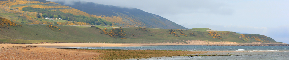
I start off from Seaford on a bright and sunny morning, heading for Brighton.

Today I plan to catch the train back from Brighton. I park near to Seaford station and walk through the town, down to the sea front, then along the promenade, heading westward.

As the crow flies, this would be a reasonable walk of 11 miles. However, my progress will be interrupted by the mouth of the River Ouse, leading to a detour into Newhaven to find a bridge across the river. So, I am anticipating a walk of 14 miles today. This is a long walk for me and I am hoping the walk will not be as strenuous as yesterday, when I went up and down, up and down, up and down – eight times – across Beachy Head and the Seven Sisters.

Yesterday, on the train, I saw kitesurfers along this beach. Today, with no wind, there is no sign of the surfers. There are young people around, school age children really, in large groups with a couple of supervising adults. What is going on? Why aren’t they in school? Then I remember. There is a strike of public sector workers today and some schools have closed. What a wonderful morning to have off school!

Ferry sailing into the mouth of the River Ouse, Newhaven. Ruth's coast walk.

As I near the mouth of the river, I see the breakwater and the lighthouse on the other side, with a bright yellow ferry making its way into the river and heading for Newhaven.

Tide Mills, ruins - near Seaford, Sussex, Ruths coastal walk.This section of the coast is a nature reserve called Tide Mills. There are old ruined structures and a sign tells me this was a place where there was a tidal mill. When the tide came in, water entered lagoons and, when the tide came out, water ran out through water wheels, powering the mill. All around here was a village, with cottages housing people who worked in the mills.

When the mill shut down, the village simply died. All that is left is the footprint of ruined foundations.

Further on, I see groups of adults working on some of the foundations, as an archaeological dig.

Wheatear - at Tide Mills, near Seaford, Sussex. Ruth's coastal walk.I started my walking adventure knowing little or nothing about birds. Now I can name some common birds and can recognise when I see something unusual. So, I knew this little bird, with a white breast and black stripes across its cheeks, was out of the ordinary.

A signboard tells me this is a Wheatear. An unusual bird. Shy and rare. This one flits around with the sparrows. After much patient waiting, I manage to take a decent photo.

I walk through the ruins of the abandoned mill village, meeting a footpath that seems to double as the beginning of the Vanguard Way and the end of the Sussex Ouse Valley Way – both long distance footpaths.

Walking towards Newhaven, Ruth's coastal walk - Sussex Ouse Valley WayThis section of path runs along a waterway parallel to the Ouse. I am meandering, slowly, along the path when a voice says ‘excuse me’ in my ear. I nearly fall over with surprise. A very speedy walker – younger, fitter and faster than me, with soft walking shoes and noiseless footsteps, overtakes me.

‘Is this the path to Newhaven?’ I call after her rapidly disappearing back.
‘Yes. Just ahead.’

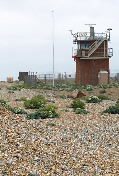
The footpath ends at a road and I am forced to walk along pavements, through a scruffy area of light-industry, past a couple of small railway stations, past the entrance to the ferry port, until I reach the bridge over the river Ouse.

Swing Bridge, Newhaven, Ruth's coastal walk, Sussex.Looking down The Ouse, Newhaven, Ruth in Sussex on her coastal walk.This bridge is a swing bridge and shows the next ‘opening’ time on a board. I am tempted to wait for 20 mins to see the bridge move. But, mindful of the long walk ahead, I decide to keep going.

I stand on the bridge and look down toward the river mouth. In the bright light, I squint past jetties and, in the distance, can see the mouth of the river with the breakwater and the lighthouse.

I remember the beginning of my walk, 14 months ago, when I set off down another river with the name Ouse – The Great Ouse River – and walked the 16 miles from Kings Lynn to Hunstanton. That seems a very long time ago.

Sculpture1- Newhaven - Ruth's coast walk.Sculpture2 - Newhaven - Ruth's coastal walk through Sussex.Sculpture3 - Newhaven - Ruth's coastal walk through Sussex.


As I walk up the west bank of the river, I notice a number of sculptures. They all feature the cormorant, the large black bird, with a long snaking neck, that has become a familiar sight to me along this section of the coast.

This side of the river is in the process of renovation. There is an odd mix of decrepid jetties and decaying wharves, alongside smart new housing and a landscaped walking route.

Eventually, I reach the marina area, with a multitude of boats of all shapes and sizes. I stop in a cafe and have a cup of tea and some cake. Now I head towards the Fort, standing on the hill, guarding the entrance to the river mouth.

Last toilets before France, Newhaven. Sussex. Ruth's coast walk.On my way up to the fort, I pass some public toilets. Some joker has placed a sign on the side of the building, ‘Last Public Toilets Before France’. It makes me smile.

Newhaven Fort, Ruth's coastal walk, In Sussex.I walk up, past the fort – now used as a museum, and carry on upwards, along a path that leads to the top of the cliff.

There is a lookout station up here. To my left is bright blue sea. To my right is a sprawling caravan park and housing estates – the edge of Newhaven, a place called ‘Harbour Heights’.

If I look back, towards Seaford, I see a beautiful sight. There is Seaford with the cliffs beyond – bright white chalk rising up from a deep blue sea, topped with a green open space and crisscrossed by the footpaths where I walked yesterday. Lovely.

View back to Seaford, Ruths coast walk.

Walk along Harbour Heights, Newhaven, Sussex. Ruths coastal walk.On this side of the Ouse, the path runs close to the cliff edge and some sections have crumbled away. I follow the pathway as best I can, heading along the green space at the top of the cliffs, towards Brighton.

I pass one walker and, much later, meet a man with a dog. Otherwise, I am alone for this, the best part, of my walk today.

Cliffs at Peacehaven, Sussex, Ruth's coastal walk.This section of cliffs is rich in fossils and is designated as being of ‘Special Scientific Interest’. Later on I will see attempts to hold back the erosive effects of the sea. But in this area, the cliffs are unprotected and it is evident, from the vanished sections of footpath, that the edges are falling into the sea.

Looking back, I can see the waves washing away material from the base of the cliff face, where the water is a creamy blue colour, as it carries away milky traces of chalk.

Now I am approaching a built up area called Peacehaven. Bungalows and houses, laid out in grids, stretch towards the sea. There is a narrow strip of green land and rough roadway, between the houses and the edge of the cliff.

Cliffs and sea wall beneath, Peacehaven, Ruth's walk Sussex coastBelow, I see a newly built promenade – a gleamingly clean, unblemished, wide, concrete walkway – winding around the base of the cliff, forming a protective buffer against the force of the waves. A flight of steps leads downwards. Although I see some construction equipment below, I see nobody working. Is it open? I hesitate. Should I go down? It would be nice to walk on that clean, flat surface, next to the sea, under the cliffs. But, how far does it stretch? After a few yards, the walk disappears behind the curve of the cliffs and I can’t see what happens next.

It is a long way down and I don’t fancy having to climb back up again.

In the end, I stay on the top.

Later, I learn that Peacehaven has an unusual and controversial history. The town appeared in 1916, almost from scratch, as a result of a land-selling scheme by a Mr Charles Neville. You can see an informal description of the history of Peacehaven at Peacehaven Online and a more considered history on the official Peacehaven Town Council site.

Meridian Marker, Peacehaven, Sussex, Ruth walks around the coast.I arrive at a monument and stop to have a drink and eat a snack. At first, I think the monument is a war memorial, but the decoration seems strange – it has a globe on top.

I read the information on the base and discover this monument marks the line of the Greenwich Meridian. Longitude 0 on the map.

This seems an important milestone in my walk, and I text the exciting news to my husband. He is in the middle of a busy working day and seems particularly unimpressed.

At the end of Peacehaven, I come across a nice pub and have some lunch. When I emerge to continue my walk, the sky had grown overcast and the clouds over Brighton look black and threatening.

Beacon Hill Windmill, outside Brighton - Ruth's walk round the coast.I walk along a busy road. The traffic is noisy.

Inland there are houses. I pass Saltdean and Rottingdean. There is a windmill on a hill. The path goes up and down across a gently rolling cliff top. Sometimes there are areas where you can access the beach and the sea below. I am never sure whether it is worth the climb down. Despite my recent stop for lunch, I feel hot and tired.

Monument with no name, Saltdean, Sussex Coast, Ruth's coastal walk.I reach an area of wide greenery and find another memorial. This one looks like a classic war memorial, but there is no inscription, no list of names, nothing to indicate what the memorial is for – or even if it is a memorial at all.

Later, I search the internet, but don’t find any information about this mysterious monument.

Heading towards Brighton, Ruths coast walkI see Brighton ahead, under a mass of dark clouds. The path continues, exposed, along the top of the cliffs. It looks like rain ahead.

Hoping for better shelter, I follow a slope down to the shore and join a promenade walk, winding along the bottom of the cliffs, heading for Brighton. There are families down here. Some sit at a little cafe. Others walk, jog, or bike along the promenade. The cliffs above are crumbly. I see the occasional rock that has fallen down. I wonder how safe this walk is?

The skies become even darker. People begin to disappear. Now there is just the occasional cyclist, pedalling back towards Brighton.

I reach a marina area, new and modern. But I decide to head back up and climb up a very steep slope to regain the high ground, walking alongside a very busy road, approaching Brighton itself.

Samaritan sign - Brighton Marina - Ruth's coastal walkThere are warning signs along the cliff here. Yet another reminder that these chalk cliffs act as a magnet for ‘despondent’ people.

I was really looking forward to arriving at Brighton. I know this is a lively, vibrant city. But, I have to confess I am not impressed. The time is around 5pm. The promenade becomes very crowded. Despite signs saying ‘no cycling’ and a clear cycle route alongside the road, people cycle at great speed along the crowded prom. I dodge cyclists, joggers, families with pushchairs, people with dogs and old people on mobility scooters. I feel tired and harassed.

Everyone seems stressed and joyless. This doesn’t seem like a seaside resort. Just another big, busy, bustling city.

Drummer, Brighton sea front - Ruth's coastal walk Below are the usual funfairs, amusements and a small train track. The beach is pebbly. The weather foul.

Then I see something that catches my eye and cheers me up.

Below is a young lad – maybe a student – sitting at a drum kit, beating the life out of his drums. A couple of teenagers, slightly tipsy, stand on the upper promenade and begin to dance and clap. The drummer finishes a particularly energetic session and, mindful of his audience, stands up and bows to the teenagers. They shout down, asking where the rest of his band are. He just laughs and continues thumping his drums.

Brighton’s pier is disappointing. It appears to have construction works going on. I see a large crane at end of it. Later, I realise it is not a crane, but a fun-fair ride.

I head away from the seafront, towards the station. The road slopes uphill and the pavements are crowded. I walk behind a group of school aged children, early teens, who walk too slowly but don’t give me enough space to overtake them. I am thoroughly fed up by the time I reach the station and very pleased to arrive back in Seaford, where I collect my car.

It is late, and I stop at a restaurant in Seaford for an evening meal. The food is surprisingly good and the service is excellent.


Miles walked = 14

Posted in 06 Sussex | Tagged , , , | 8 Comments

52. Eastbourne to Seaford

West side of Eastbourne, Ruth's coastal walk.This morning is gloriously sunny. What a fantastic day to walk up Beachy Head! My hotelier tells me it is the first clear day they have had for weeks.

I walk up a long, sloping promenade, taking me westward from Eastbourne. I remember coming here as a child with my grand parents and I swear there were formal gardens here – with bright flowers planted in intricate patterns. Now there are a wonderful plants growing alongside the walk, looking entirely natural, but I am sure this apparent random arrangment was by careful design.

Ahead, in the distance, I can see the South Downs rising up. And there is a steep path winding up the side of the green slope. (You can see it in the photo.) I wonder if that is where I am heading.

I check with a gentleman who is standing admiring the sea: is this the way to Beachy Head? Yes, he says. Then he looks me up and down as if measuring my ability.
‘But it’s a steep climb. You have to be tough.’
Obviously, I don’t look tough enough.

View over Eastbourne, Cow Gap, Ruth's walk around the coast.When I reach the green hill, footpath signs point straight up – along the path I could see from the promenade below. This marks the beginning of the famous long distance foot path, The South Downs Way.

Feeling a bit of a coward, I decide not to head directly up the steep slope. Instead, I choose to walk around the edge of the slope, keeping close to the sea. I justify this to myself. After all, my quest is to walk around the coast.

I can’t escape the incline and find myself climbing higher. From here there are wonderful views back towards Eastbourne. I stop to catch my breath and take some great photographs.

Up here the landscape opens out into a natural bowl. The grass is green and the sky blue. All around are beautiful wild flowers. High above me is the ridge of the South Downs. I can see the shapes of people, silhouetted against the blue sky, high up on the crest of the downs. It looks busy up there and I am pleased to be down here. Apart from a couple of solitary dog walkers, I am alone.

Wild flowers, Beachy Head, Sussex, Ruth's coast walk.Cricket Pitch, Beachy Head, Ruth's coastal walk.People on the ridge, Cow Gap, Beachy Head, Ruth's coastal walk.

Somewhat to my surprise, I find a cricket pitch, with the boundary marked out in chalk and a score board.

Now I reach a section called ‘Cow Gap’ on my map. This is rather an ugly name for a beautiful place. Here the slope rises steeply and the cliff is crumbling. I am forced to turn uphill and end up climbing a very steep slope, up to the top of the Downs, joining the other sightseers at the top of the ridge. I hear excited voices and realise I am scrambling up towards a group of Italian children on a school outing. As I climb up to meet them, I have to climb over a fence. On the fence are signs telling visitors not to go down (the way I have come up) because the cliffs are unstable.

At the top of Beachy Head. Ruth's coastal walk. There are a lot of people around. I am surprised to see so many. Usually, few people stray more than 100 yards from a car park. Then I realise. There is a road up here – and a car park. That explains it.

I meet other walkers, women of a certain age – even older than me. They tell me on a clear day you can see the Isle of Wight.

I get out my binoculars. Looking back to the east, through the binoculars, I can see the white cliffs of Hastings, where I walked with my husband a few weeks ago. Beyond I can just make out the squat, grey shape of Dungeness Power Station. Looking eastwards, in the direction where I imagine the Isle of Wight to be, I can make out some land on the horizon. But I have no idea if this is the Isle of Wight or Worthing or Selsey Bill.

Beachy Head light house, Ruth's coastal walk.

Beachy Head, painting by Tim Baynes - Artist in Residence - Ruth's coastal walk

Original artwork, by Tim Baynes, derived from my photo.

The view up here is truly magnificent. Chalky cliffs drop down to a pale blue sea. Far below is a lighthouse, red and white. It looks tiny – but its light can be seen for 26 miles out to sea. Today the tide is high. Waves are lapping against the cliffs and carrying away a chalky sediment. This turns the sea at the base of the cliff a beautiful pastel shade of light blue.

The land around is owned either by the National Trust or by the local council. There is free right to roam. This is an incredible place.

As I walk along the top of Beachy Head, following the well trodden path, I notice how little protection there is from the sheer drop. In places there is a rudimentary wire fence. In other places, there is no barrier between the path and the cliff edge.

Memorial flowers at Beachy Head, Ruth's coastal walk.Memorial at Beachy Head, cross and flowers, Ruth's coastal walk.


I come across a poignant sight. Shivers go up and down my spine. Here, along the crumbling cliff edge, are tributes to people who have died. There are bunches of flowers and little crosses – 5 or 6 little memorials. They are sited where the path comes very close to the edge of the cliff.

Perhaps this is where people scatter the ashes of loved ones? I hope this might be the case. But I know I am wrong.

I think back to my arrival at Eastbourne station. One of the things that struck me was the sign at the station exit with an advert for The Samaritans and a signpost. Usually access to the Samaritans is via a phone line but here they have an actual physical office for people to visit. There are signs up here too, with the Samaritans’ phone number.

On a beautiful day like this, it is hard to imagine anyone wishing to end their lives. But it happens. And this place is a magnet for the sad and desperate. Beachy Head – with cliffs towering 530 feet above a shallow sea – is the 3rd most popular place in the world for suicides. There are, on average, 20 a year.

From Beachy Head, the path continues along the top of the cliffs, dipping down a little and then rising again towards the old Belle Tout Lighthouse. The function of this lighthouse has been replaced by the newer lighthouse – the red and white one in the previous photo, perched in the sea just below the towering cliff face. The old lighthouse is in use as a residential building.

I read a signboard and learn of an amazing feat of engineering. In 1999, due to continual erosion of the cliffs, the old lighthouse was in danger of being lost. So it was picked up and moved 50 feet further inland. Sadly, as this cliff continues to be eroded at a frightening pace, it may need moving again soon.

Birling Gap, Sussex, Ruth's coastal walk.The path detours around the lighthouse and ahead of me stretches a long, undulating walk. Naively, I believed once up here the walking would be flat. I had forgotten about the Seven Sisters. Dimly, I remember my grandfather telling me about the seven chalky cliffs that accompany Beachy Head. Here they are.

But first, it is lunch time. Down in a dip is Birling Gap. Here there is a car park, a small collection of houses, a visitors centre and a cafe. The houses look perilously close to the cliff edge. I wonder how long they will last.

Access to the beach is provided by one of those scaffolding type steps, the sort I first came across in East Anglia. The gangplank connecting the steps to the cliff can be moved as the cliff becomes eroded. There are school children (Italian I think) on the steps, coming up from the shingly beach and about to board their coach.

In the cafe, I have a surprisingly good meal, sitting in a small room with large windows overlooking the sea.

Walking over Seven Sisters, Ruth's coastal walk, Sussex.After lunch, I tackle the Seven Sisters. This is the official South Downs Way. Down goes the path, and up again, down and up. Seven times.

I meet a few walkers, but no tourists. There is no easy access to the Seven Sisters – you have to walk – up and down.

One walker is resting at the bottom of the dip between two of the ‘Sisters’. He is taking medication and swilling it down with his water bottle. Pain killers, he tells me. For his knees.

The peaks become progressively higher. It is like descending a giant roller coaster, but in reverse.

I mount the last ridge (I don’t realise it is the last ridge – I have lost count) and see a beautiful bay ahead of me.

Cuckmere Haven, South Hill, Ruth's coastal walk.

This is Cuckmere Haven. I wasn’t expecting it to be so magnificent. There is an extensive shingle beach and, on the other side, chalk cliffs again, stretching towards Seaford and Brighton beyond. All around is the rolling green of the South Downs. Perfect view. Perfect scenery. Perfectly English.

Japanese tourists are making their way up the slope towards me. The women are wearing thin soled ballet-pump shoes. They are, obviously, not serious walkers. Below, people are out on the exposed beach, enjoying the sea and this beautiful bay.

Cuckmere Haven, Seven Sisters Country Park, Sussex, Ruths coast walk.My intention is to leave the South Downs Way, which turns inland, and to cross over the bay, joining the Vanguard Way (another long distance footpath) as it heads over the cliff, following the coast to Seaford. But, as I suspected, a river intersects the bay. From up here the channel of water looks narrow. The tide is out. I wonder if I can walk across?

I see a man with a dog by the edge of the river mouth. Taking out my binoculars, I watch the man. He removes his shoes and wades into the river. He walks gingerly, hands outstretched for balance. The dog splashes at the edge of the water, but doesn’t join him. I watch for some time. He doesn’t make much progress across.

I want to scramble down the cliff and walk towards the river mouth, to judge for myself whether a crossing is possible. But the cliffs here are steep and warning signs tell me not to attempt the direct path down. I would have to go inland for a few hundred yards, descend the slope and then head back out to the shore again. I am reluctant to expend energy on a fruitless quest and, deciding the river crossing looks improbable, I turn inland.

Algae in lagoons - Seven Sisters Country Park, Ruth's coastal walkHeading downwards, I follow the river valley. Just beyond the shingle beach is a stretch of watery marsh and lagoons. The water is brightly coloured with, I assume, algae. It is a striking sight.

Following the valley, I am heading for the Exceat Bridge. This is the nearest crossing point to the river. The whole area is part of the Seven Sisters Country Park and there are a number of serious walkers and not-so-serious ramblers out, enjoying the sunny afternoon.

Towards Exceat Bridge, Seven Sisters' Country Park, Ruth's walk around the coast.I walk along the raised river bank. Progress is difficult because of vast amounts of sheep droppings. The sheep are cropping the grass nearby and a lamb bleats mournfully from beside a water bowser. I think it is calling to its mother, but another walker has stopped to watch and, in her opinion, the lamb is distressed because it can’t drink the water in the trough – the water level inside is too low for the lamb’s short neck to reach. I pause for a while. It has been very dry. Apart from the showers yesterday, we have not had any serious rain for more than 3 months. There is water around, but it is probably saline. For a moment I contemplate going down to the bowser and turning on the tap. Then I consider the farmer will round the sheep up shortly (it is late afternoon).

I continue walking and cross over the bridge, stopping for a drink and peanuts at a pub. Cheeky sparrows perch on the table, wanting some of my peanuts; they eat from my hand. I force myself to stay here for 20 minutes, knowing I will need energy to complete today’s long walk.

Following the river (now on the other side, of course), I walk back down towards the sea. By the time I reach the coast, the sky is overcast.

As the path leads up the gentle slope to the top of the cliffs, I find a man with a huge camera on a tripod. He is waiting for the sun to come out. The man tires of waiting, picks up his equipment and begins trudging up the slope, following the same path.
I turn to see what he was planning to shoot. And there are the Seven Sisters.

Seven Sisters, view from Seaford Head, Ruth's coast walk

For the rest of this section of the walk, I keep turning back to look at the white cliffs. The sun makes brief appearances between short breaks in the cloud and lights up sections of the Sisters. I manage to take a few great photographs of this dramatic view.

View towards Seaford, Ruth's coastal walk in SussexThe remainder of the walk is tiring but very satisfying. The sun slants across the landscape, flitting in and out of the clouds. The weather is warm. The scenery is beautiful.

Finally, I reach the crest of a slope and see Seaford spread out below me. In the distance, the shore line curves around to gap marking the entrance to Newhaven. Beyond that, barely visible as I look into the glare of the late afternoon haze, must be Brighton.

Seaford has a wide, empty promenade. There are ordinary houses, a few hotels, some restaurants. There is nothing pretentious about this town. It seems an ordinary place where people live and work, but with a great sea front. I find the station and catch a train back to Eastbourne, via Lewes.

“Which platform is the train leaving from?” I ask the young man at the ticket office.
He smiles.
“There is only one platform here.”
And he kindly tells me which platform I need to go to when I reach Lewes.


Beachy Head, painting by Tim Baynes - Artist in Residence - Ruth's coastal walk

Original artwork, by Tim Baynes, derived from my Photo of Beachy Head.

This wonderful picture was painted by my ‘artist in residence’ – Tim Baynes. Please visit his website. timbaynesart.co.uk.

Vital stats: miles walked = 13 miles, 1 new blister.

More information:
Beachy Head and Seven Sisters Country Park.
Beachy Head Chaplaincy Team with their tally of ‘despondent’ people rescued, week by week.


Posted in 06 Sussex | Tagged , , , , | 7 Comments

51. Bexhill to Eastbourne

Herring Gull, Eastbourne Station Platform. Ruth's coastal walk.Eastbourne station has noisy gulls that walk along the platform, bold in their approach, hoping for food. At first I think this particular gull has a piece of red meat (or blood) staining its lower beak. Later, I realise it is a coloured mark characteristic of Herring Gulls; a species in decline at the moment – although you would not guess it from their intrusive, noisy presence on this railway platform.

I catch the train to Cooden Beach, just to the west of Bexhill. The train trundles along, at a leisurely pace, past houses, lakes, countryside and then along the beach itself. Cooden Beach station is deserted and I am the only person making my way off the platform, down the gently sloping ramps, to the street. The beach is a short walk away.

I reach the beach, stumble over the shingle and head for the waterline. The tide is low, and there is a narrow band of sand close to the waves. I walk here, dodging the occasional incoming wave, where the ground is firmer and progress possible.

Beach Huts, near Bexhill, Sussex. Ruth's coast walk.
The beach is deserted apart from a lone dog walker. Ahead, at the top of the beach, I see a line of beach huts; empty on this Tuesday morning in June – with rain and thunderstorms forecast.

Further ahead, around a gently curving bay, I can just make out the squat shape of a Martello Tower. This is shown on my map as being the other side of Norman’s Bay. Norman’s Bay, despite its name, appears as a straight piece of coastline on the map. I have become so used to seeing curves in the coast where none exist on the map, I have given up wondering if this is my eyes playing tricks, a phenomenon to do with the earth’s curvature, or the result of a misleading straightening out of coastline curves by mapmakers.

Gulls in Norman's Bay, Sussex. Ruth's coast walkThe beach is empty, apart from the ubiquitous gulls. These are youngsters, with their mottled plumage. Will they grow up to be Herring Gulls or another sort of gull?

After a while, the strip of sand becomes covered by waves and shingle walking becomes too tiring. I move up to walk along the top of the beach, where the shingle is more impacted and the going becomes a little easier.
sign about oil, Norman's Bay, Sussex. Ruth walks round the coast.
Here I see posts with life rings. They carry, as usual, warning signs.

For some reason, councils seem incapable of simply putting up a post without attaching bossy signs of various sorts. In Kent, I became used to seeing signs listing the dangerous things to be found on the beach (slippery rocks, hidden obstructions, deep water, mud, etc), so the simplicity of these warnings intrigues me. Apparently, the only thing I need to worry about here is the possibility of oil on the beach. And, if I find any oil, it is definitely NOT the fault of the council. Jolly good.

Martello Tower 55, Norman's Bay, Sussex. Ruths's coastal walk.As I near the Martello Tower (number 55), I see that it is in the process of renovation. The external stone seems far too clean and new – so I suspect most of the tower has been rebuilt. These towers are covered by conservation orders and the outer shape has to be preserved with only a limited number of small windows allowed and, therefore, most conversions involve roof skylights to channel the light into the interior of the structure. This conversion seems to be following the usual pattern, with an intriguing top deck involving large amounts of glass. When it is finished, this will be a fantastic place to live – with wonderful panoramic views over the sea.

Cormorant, Beachlands, Sussex, Ruth's coastal walkI see a large, hunched bird – black and brooding – perched on one of the groin markers. This must be a cormorant. There is something both magnificent and sinister about these birds.

I have no real experience of bird watching but, with the aid of photographs and the wonderful RSPB Bird Identifier page, I am learning to recognise and name the common sea birds as I meet them.

After walking through Norman’s Bay, and past its scaffolding-clad Martello Tower, I approach a place called ‘Beachlands’ on Pevensey Bay. Pevensey Bay runs from Beachlands up to the beginning of Eastbourne.

There are more people around now, walking with dogs, sitting on the shingle, and walking along the top of the beach.

Meanwhile, the sky gets darker. Storm clouds are gathering and I wonder if it is going to rain. I pull my waterproof jacket, neatly packed into a roll, out of the bottom of my rucksack and stow it on top of my water bottles, just to make sure it is easily accessible in case the promised thunderstorms start. Although I don’t mind getting wet, I worry about my iPhone and my camera.

Martello Tower 61, Ruth's coast walk, Pevensey Bay, Sussex.Martello Tower 62, Pevensey Bay, Ruth's coast walk through Sussex. There used to be numerous Martello Towers on this section of coast and, although only a fraction of them remain, there are another two here; number 61 and number 62. Both appear to be in use as residential dwellings. One, although unfortunately positioned in the middle of a static caravan park, has a most amazing garden – full of ornaments and statues.

Martello tower 64, approaching Eastbourne, new development. Ruth's coastal walk.As I get closer to Eastbourne, I come across a new development. Tall blocks of apartments, with large balconies and fantastic views, line the beach. Behind these are even more apartment complexes. A whole new section of Eastbourne has sprung up here. It is all neat, tidy and organised. I even spot a bus, winding through the estate.

Martello Tower 64, East side of Eastbourne, Ruth's coastal walk in SussexAnd in the middle of this high-rise modernity is a lone Martello Tower (number 64), sad, dilapidated and falling into ruin. I imagine there is some grand plan for it. But at the moment, it looks very out-of-place with the modern buildings alongside.

At this moment, I hear a rumble of thunder and the heavens open. I pull out my rain jacket and seek shelter under one of the balconies. The rain thuds down with satisfying vigour. There is that wonderful smell of newly wet dusty earth. The world turns grey. The sky grumbles. My path becomes a giant puddle.

During this wait, under the dripping balcony, something surreal happens. I see another walker coming towards me. He is young, tanned and muscular, wearing shorts and proper walking boots, enveloped completely in a transparent plastic raincoat, which covers not only his upper torso but is stretched over his rucksack as well. So he has a strange appearance as if his upper body is swathed in clingfilm. I turn away for a moment and, when I look back, he has disappeared.

The rain lessens slightly and I continue walking. Passing a recess in the buildings I discover the young walker. He appears to be lying face down on the ground. Slightly alarmed, I begin walking towards him. Maybe he has been struck by lightning? Then I realise – he is doing press ups. He is using his knuckles (not the flat of his hands) to push up with. The ground is soaking wet, it is still raining, he is wrapped in his plastic rain jacket with his rucksack on his back. What an odd sight.

New development, Eastbourne, Ruths coastal walk.

Cormorant - Eastbourne - Ruth walks the coastThe path takes me round a rectangular harbour area, lined with the new buildings. It is very pleasant.

And there, in the midst of this modern developement, I see another cormorant at the water’s edge. It is standing with its wings outstretched, drying them. I can’t resist taking my camera out (despite the rain still falling) to catch a few shots.

Another mystery occurs to me. Earlier on, I saw a few boats pass passing into the harbour, heading for shelter from the weather. Although I saw them moving into the harbour, now I have a clear view of the harbour itself, I can’t see the boats. Where have they gone?

Locks, Sovereign Harbour, Eastbourne, Ruth round the coast A few minutes later the mystery is solved. There is an inner marina, crammed full of boats; mainly yachts and small motor craft. To access this inner waterway, you pass through a lock. In fact there are two locks. One of them is currently in operation, with a ship being slowly raised as water pours in, getting ready to dock in the safety of the protected marina.

I was anticipating a trudge around the marina area to reach the coast on the other side and to continue my walk into Eastbourne. This turns out to be unneccessary, as I can cross over the mouth of the marina using pedestrian walkways that run across the locks. A system of traffic lights controls where and when these walkways can be used. I linger here for a while, watching the locks in action and marvelling at the mechanical means by which large masses of water can be raised and lowered.

Amazingly, in this newly developed area, I see a small white egret on the edge of the water, seemingly oblivious to the high rise apartments, the cyclists, joggers and walkers who have emerged as the rain subsides. I wonder how long this area will continue to be attractive to the cormorant and the egret.

Martello Tower 66, Langney Point, Sussex, Ruth's walk round the coast.On the other side is Langney Point and here, in a dilapidated state, is another Martello Tower (number 66). Again it looks as though this is in the process of renovation, surrounded by scaffolding and draped in plastic.

By now the dark skies are lighter and the rain has cleared. We were promised huge thunderstorms but the whole event has lasted less than an hour.

(Later I learn some local houses were hit by lightning strikes and, in retrospect, I was lucky to have experienced little bad weather during this walk.)

As I round Langney Point, I can see Eastbourne ahead and Beachy Head rising beyond. My legs are tired and I am looking forward to ending my walk for today.

Water Treatment Works, Ruth's coastal walkNow I find I am walking past a large building with a modern design and nice, flowing shapes. A sign tells me it is water treatment centre. Really? It looks far too imposing to be a sewage works. But that is what it is. And I gather, according to the local news, all has not been smelling sweet in the locality. But today there is no whiff of sewage in the air.

Deckchair with your logo here - images of Eastbourne - Ruth walks round the coast.I head towards Eastbourne along a lovely wide promenade, with a cycle track and a pedestrian walkway. On my left is a patch of shingle with natural plants growing, including flowers and the shingle beach beyond. There are also fishing boats and tackle, sailing dinghies and windsurfers. It is a wonderful amble and, despite the grey skies, I enjoy it thoroughly.

Unfortunately, it is too dull for good photography and I am too tired to linger and struggle with the finer points of camera control. But I do snap these colourful deck chairs. How could you resist advertising your local business here?

Martello Tower 73, Eastbourne, Ruth's coastal walkBeyond the pier, at the Western end of Eastbourne, is another Martello Tower (number 73 according to the classification)

I am very impressed by Eastbourne. I expected a run down seaside resort, full of old people. Yes, there were many elderly people, but there were also middle-aged and young people with families. Due to the shingle beach, this will never be a bucket-and-spade resort for young children, but I found it attractive and pleasant.

Finally, here are two photos of the lovely pier. One is taken in the morning light and the second in the evening.

Eastbourne Pier, Ruth on her walk around the coast. Sunset, Eastbourne Pier - Ruths coastal walk.


Vital stats: miles walked = 9 miles, rainstorms = 1, Martello Towers = 6.


Posted in 06 Sussex | Tagged , , , , | 4 Comments

50. Hastings to Bexhill

Love the pier - Hastings - Ruths coastal walk, SussexI am staying in Eastbourne and I take the local train to Hastings to continue my walk. After stopping for lunch (fish and chips, of course), I walk through Hastings towards the beach and emerge by the pier.

What a sad sight this pier is!

Burnt buildings, roofless wrecks, timbers showing, seagulls perching on shattered planking – a blackened and rusting structure. Warning signs advise people on the beach to stay away and not to walk beneath the pier, in case timbers fall on your head.

But attempts are being made to save it. Although the entrance to the pier is closed and barred, bunting hangs across the gate and signs proudly declare that the pier is loved and can be saved. I am not so sure.

Hastings Pier, Ruth's coastal walk

Leaving the sad pier behind, I walk along the wide promenade, heading westwards. I sit in one of the shelters, in the shade, and have a drink. The sun is hot. I apply sun block before continuing.

Promenade at Hastings - Ruth walks the coast, Sussex
A hundred yards further along, I stop to check my phone and realise it is not in my pocket. With a sinking feeling, I empty out my rucksack and search through the maps, tissues, plaster, drinks bottles and various spare bits of clothing I have crammed inside. No sign of my phone. I must have left it on the seat when I stopped in the shelter. Surely someone will have picked it up and taken it. Who could resist a free iPhone?

It is hard to run in walking boots, but run I do – back to the shelter. On the black painted seat is my black iPhone – barely visible, black on black. What a relief!

Shingle beach with hut, Hastings, Ruth's coastal walkLeaving Hastings behind, I walk along a gravel path that runs along the side of the railway line, parallel to the beach and behind a jumble of huts, boats, fishing tackle, and sheds. I would prefer to walk on the beach itself, but the tide is in and there is no sand; I would be walking on rough shingle, too much like hard work, especially in this heat.

This track is not marked as a footpath on my map and I am not clear if I can make it from here to Bexhill without detouring inland. Knowing my route inland is barred by the railway line, I am hoping I don’t reach a dead-end. I don’t want to have to retrace my steps.

Hastings view, Ruth's coastal walk
I reach an area called Glyne Gap on my map. The tide has retreated and I can walk across wet sands. There is a great view across to Hastings. I stop and take photographs. Unfortunately, I don’t manage a self-portrait – I fail to get to the right place in the 12 seconds I am allowed. So I end up with a number of photos of an empty beach.

Apart from a dog walker and a cyclist (who has wobbled his way across the beach), there is nobody close by.

Now a mass of rocks bars my way. The arrangement of the rocks doesn’t look natural. I guess they have been placed here to prevent erosion. I am forced to turn inland. Luckily, I find a path leading up from the beach to a hill (Galley Hill on my map, where I stop for a rest on a bench and admire some great view). Then I follow a path along a low cliff, heading towards Bexhill.

Bexhill, Ruth's coastal walk, in SussexI see Bexhill ahead of me and the path slopes gently downwards, running alongside a quiet road.

Bexhill, motor racing plaque - Ruths coastal walkHere I come across a plaque commemorating the ‘First International Motor Race Meeting’, which took place in Bexhill-on-Sea in 1903. This quiet road must have been part of the race track.

I imagine a time, years ago, when racing cars were quieter, slower and you could race along a winding beach road. How exciting, and daring, such a race must have seemed.

Bexhill beach, Ruths coast walk, SussexThe beach in Bexhill is a mix of sand and rocks – creating an exciting playground of rock pools and beach for children to play in. This is a great beach for families – and a nice change from the shingle beaches at Hastings.

Bexhill promenade, Ruth's coastal walkI walk along the promenade, that narrows as I leave the busier part of Bexhill behind and I find I am walking alongside some very nice seaside properties. These houses have gardens that open directly onto the promenade.

I have a train to catch from one of the little stations that are dotted along the railway track. The station I am heading for is called Cooden Beach and, when I arrive, I find it is unmanned and deserted. I buy my ticket from a machine and walk up a long, covered slope to the platform. I find myself alone.

While I wait, a recorded message booms out over the announcement system. It tells me it is hot and I shouldn’t travel without a bottle of water – and then kindly informs me my train is about to arrive. I wonder where I should buy my water from, on this deserted station. And is it possible to buy water in the 30 seconds I am given between the announcement and the train arriving? For whose benefit is this announcement being made?

Later, I learn that trains broke down in North Kent earlier today. Passengers, overcome by the heat, forced their way out of hot railway carriages. The authorities shut off the power to the ‘live’ rail, causing further disruption. Sounds like a miserable time was had by many commuters trying to make their way home.

My train arrives on time. I am glad to rest my feet during the short journey back to Eastbourne.


Vital stats:
miles walked = 8
blisters = 0
sunburn = 0
lost phone = 1, found phone = 1

Posted in 06 Sussex | Tagged , , , , | 4 Comments

49. Rye Harbour to Hastings

Track from Rye Harbour, Sussex. Ruth's coastal walk.It is bank holiday Monday – the last weekend in May. I am looking forward to today’s walk. There is, apparently, no right of way along the sea wall, so I leave Rye Harbour following a track running just inland of the shoreline. I am walking through a nature reserve area, alongside lakes.

Unfortunately, this section of the walk proves to be not as scenic as I hoped. The nature reserve is in the process of being constructed. The lakes are hidden by tall bushes. Private signs force me to stick to the track. I see no birds, no water, no sea – this path is somewhat boring.

Doggie Bar, Winchelsea Beach, Ruth's coast walk.I approach Winchelsea beach and houses appear, lining the track. The track widens into a road. I meet young girls, in brightly coloured welly boots, taking dogs for walks. The girls wear shorts and thick jackets. The wind may have dropped, but the sky is overcast and it is not warm.

Somebody has created a doggies’ ‘organic’ drink bar by the side of the road. I find the sign amusing and stop to take photographs.

The track joins the sea wall.

Winchelsea Beach, looking back to Rye Harbour, Ruths coast walk.Here there is a wide shingle beach and a narrow walk-way along the sea bank. I look back towards Rye Harbour. I guess I could have walked along the coast after all.

Red flag on Winchelsea Beach, Ruth's coastal walk.Looking in a south-westerly direction, the shingle beach stretches round a point and beyond, towards distant cliffs. That must be the aptly named ‘Cliff End’, shown on my map. There is a high cliff in the distance, pale in the haze, and I wonder if this is Beachy Head.

A red flag is flying. I presume this means ‘no swimming’.

Ruth on Winchelsea BeachI sit for a while and have a drink, eating a snack. I remember how to take a self-portrait using my camera’s timer (I am getting better at this).

In the photo I look relaxed, despite having run across the beach to get into position.

I walk along the shingle beach – not on the shingle itself, but sticking to the path running along the sea wall.

I pass a low area where there is a green field and people playing football. An information sign tells me that this green space was the site of a New Harbour, built at great expense to replace Rye Harbour further up the coast, after the old harbour became blocked with silt and shingle. The New Harbour opened in the summer of 1787 but, after only three months of use, itself became the victim of shifting shingle and was also blocked. The New Harbour was abandoned in October 1787.

I am amazed to learn that the old Rye Harbour is still kept open, as a functioning harbour, by continual dredging to remove 55,000 tons of shingle a year.

Looking towards Cliff End, Ruths coast walk, Sussex.Below the sea wall is a road. A few cars pass to and fro. Sometimes a car stops, people get up and climb the bank, look at the sea for a few moments and then return to their cars.

While I walk, a truck stops in a lay by on the road below. The front passenger door opens and three men in yellow vests fall out. Literally, they fall out. The one on the bottom starts wailing in mock protest. The others hoot with laughter. Seeing me above them, he quickly gets up. One of the men takes the bag from the bin by the road, throwing it into the back of the truck. The three men pile back into the front seat and the driver, who remained in the cab, starts the truck up again.

A few minutes later, I see them repeat the exercise, in another lay by, further down the road.

Three men to empty one bin? I wonder why. Could this have anything to do with it being a bank holiday Monday? Overtime payments, perhaps?

View across Pett Level, Ruth's coastal walk.The clouds clear and the sun comes out. To my right, I look across Pett Level, across green fields dotted with sheep and up to a windmill on a rise. Somewhere, just before the land rises into a ridge, is the Royal Military Canal and the long distance path that runs along it.

Later I learn the Canal was built as a defensive ditch – to defend Romney Marsh from an anticipated invasion by Napoleon. This incredible project (the 28 mile ditch was dug by hand – using picks and shovels) was not completed until the Napoleon threat had passed. Embarrassed by the cost – the defensive ditch was converted into a navigation canal. Now it is used by fishermen, walkers and cyclists. Some sections are still open for boats.

Cliff End, Sussex, Ruth walks the coast.I expected to find the opening of the Canal, where it joins the sea. But I never did. Instead, I find myself walking along a promenade at a place called ‘Pett / Cliff End’. The promenade ends in a dead-end.

I retrace my steps and join the road. After a short while, I find a footpath off to the left. The footpath leads upwards, steeply climbing up the slope that marks the beginning of the cliffs. I walk along the back of gardens. In some places, the path is very narrow – high garden fences on one side, bushes and a steep drop on the other.

Fairlight Cove, Ruth's coastal walk, through SussexWhen I reach the top, I walk along the side of fields and can see the base of the cliff at an area called Fairlight Cove. It almost looks as though the cliff has been quarried here. But, in fact, the cliff has crumbled into the sea (the coast moving 100m inland in the past 100 years) and attempts have been made to pile earth and rocks at the base to protect against further erosion.

Later, I find out there is a naturist beach at Fairlight Cove – although access to the beach is deterred due to the dangers posed by erosion. There are great fossils to be found here. And dinosaurs’ footprints.

I see no fossils, no dinosaur footprints and no nudists.

But I do meet my husband in the village. He has walked along from Hastings to meet me. He has managed to find a pub for lunch and keeps me company for the rest of my walk.

John carrying rucksack, path goes up and down ahead. Ruth's coastal walk.Resting Ruth on her walk around the coast, Sussex.Ruth scrambling up path, Fairlight Glen, Ruth's coast walk through Sussex.

The walk from Fairlight Cove to Hastings is lovely. This is a Country Park, with free right to roam. Multiple footpaths criss cross over the top of the cliffs. And the going is not easy. We go down into dips, climb up steep banks on the other side, down again, up again.

The sky has clouded over and rain threatens to come but never actually arrives. Sadly, my photography is ruined by the poor light.

John contemplates climbing down to the beach, Ruth's coast walk.Signs tell us access to the beach below is not advised, although we do see narrow tracks leading downwards. We come to one such path and meet a family climbing up. My husband asks if we can get down to the beach below and a young man in the group says we can, if we don’t mind climbing a bit.

We head downwards, following a small stream, clambering over rocks, until we emerge on a natural ledge, 10 feet or more above the beach. The sun comes out. The beach below is invitingly sandy. It would be great to walk into Hastings along the sand. But the climb down to the beach is exactly that – a climb. In walking boots! It is impossible.

My husband is reluctant to give up the notion of getting onto the beach. Eventually I persuade him it is best not to risk broken bones. We turn back and scramble back up, the way we came, to rejoin the walk along the top of the cliffs.

When we reach Hastings, there is a lovely stretch of greenery at the top, with an ice-cream van, and people walking. From here we look down on the town and its pier. It is late afternoon. The clouds have broken. The sun is in our eyes, bouncing off the water, turning the sea silver.

Hastings, from the cliff, Ruths coastal walk.

We follow steps that lead down from the cliff, and emerge through a narrow alleyway onto the sea front itself. The beach here is very shingly. We see a family feeding seagulls – with much flapping and noise.

Seagulls on beach at Hastings, Ruth's coastal walk.

Ahead, as we walk along the promenade, we see the pier. It is a blackened ruin – broken and burnt. What a sad sight!

Just beyond the pier is our car. I am very tired, having walked many miles and up and down. My husband, much to my annoyance, is still full of energy and, even more galling, is completely and utterly blister-free.

Hastings Pier (burnt) Ruth's coast walk


Vital stats: miles walked = 12


Posted in 06 Sussex | Tagged , , , , | 3 Comments

48. Lydd to Rye to Rye Harbour

This morning is wild and very, very windy. My husband drops me at a roundabout in Lydd. I am three miles from the sea and have a long inland walk ahead of me.

Skirting round the military camp, Lydd, Ruth's coastal walk.Before setting off this morning, I was beset with indecision. I stopped my last day of walking at Lydd and I have to start my walk today from the same place, Lydd. My mission, to walk as close to the coast as I can, would suggest I return to Dungeness and make another attempt to walk along the shingle bank to Camber. But, there is no guarantee the firing range will be open and, if I can’t make the walk along the shore, I will be forced to walk all the way back to Lydd just to get round the ‘danger area’.

Sometimes I wish I hadn’t created so many rules! But, if I am claiming to walk around the coast, then cutting out sections because it is too difficult is simply not an option.

Lydd, path to Camber and Rye, Ruths walk around the coast, UK.So, I walk through Lydd, past the army camp, heading for the B2075 for Camber and Rye. There is a cycle way that runs along this road and I hope the walking will be safe and easy. I walk across a wide area of common land and notice the grass is brown with dry, bare patches – as though it was the end of a long, hot summer – not late May.

The cycle way is new, smooth and runs along the road, but separated from the traffic by a screen of bushes and tall grasses.

Out in the open, I experience the true force of the wind. I am really, really glad I haven’t tried to walk along the shingle today. If I found it difficult and tiring yesterday, it would be doubly so today.

Pylons from Dungeness Nuclear Power Plant, Kent, Ruth's coastal walkThe cycle track passes under the line of pylons, carrying electricity from the Nuclear Power Station at Dungeness. The pylons fizz and crackle with their electrical charge. I stand, buffeted by the wind, enjoying the noise and the exhilarating sensation of being close to such immense, and lethal, power.

Suddenly there is a screech of brakes and a young lad on a cycle skids and swerves to avoid me. I am irritated. Young rascal. Then he says, very politely, ‘I’m sorry. It was my fault.’

As he cycles off, I consider my instant and unfair reaction. It wasn’t really his fault. He was cycling along the cycle path, probably head down struggling with the wind, and came across a middle-aged woman standing in the middle of the path, looking up at a pylon. It was, obviously, not his fault – it was mine.

Lakes near Lydd, Kent, Ruth's coastal walk
The path winds along, with the road and military range beyond on one side. On the other side is a view across windswept lakes and farmland. In the distance I see quarry works (I believe these lakes are the result of gravel extraction) and, nearer the coast, a wind farm. There are birds on the lake, including wind-blown swans, heads tucked protectively under their wings.

I pass Lydd Caravan Park, where static caravans are parked around and beneath the hissing, sizzling pylons. A sign declares units for sale, under the heading ‘Do you want the quiet life?’. I am not convinced, listening to the crackle of electricity and the whistling of the wind, that this is the best-selling point to feature.

Sheep sheltering from wind, Jury's Gap Sewer, Ruth's coast walk.
Further along, I come to a pile of old hay bales, piled into a stack. A group of sheep and their lambs are around the bales. At first I think they are eating. But the bales are old and are not there for nourishment. They are a wind break. The sheep see me approaching and begin to move away. As they leave the lee of the bales, the wind catches their fleeces and tugs their wool into wild shapes.

Kent - Sussex border, near Lydd, Ruth's coastal walkI come across a signpost on the cycle track and realise I am on the border of Kent, about to cross over into Sussex. Another county and another milestone on my walk.

The cycle track changes, instantly, at the junction between Kent and Sussex; smooth tarmac gives way to rough gravel.

Cycle track, Lydd to Camber, Ruths coast walkRound the corner and I meet a couple of cyclists, heading towards me. Their tyres bounce and skid on the gravel. How do they get to Dungeness? I explain they have to go to Lydd and turn right. The girl looks fed up and remarks it will be difficult cycling back against the wind. I tell them there is a pub in Dungeness. This seems to cheer them up. Later, it occurs to me that the last leg of their trip – from Lydd to Dungeness – will be against the full force of the gale. I wonder if they make it.

As I approach the sea, the wind gets worse. The road reaches the coast, at a place on the map called Jury’s Gap, where a few windswept houses huddle together. I climb up onto the sea wall. It is great to be back on the shore, but the force of the gale takes my breath away. I am truly glad, in retrospect, not to have attempted the walk along the shingle from Dungeness to here.

I look along the bank to the East and see, beyond the firing range, the hulk of the nuclear power station looming, dully, in the distance. The sea is grey, the waves high, the surf beats and lashes at the shingle.

Jury's Gap, East Sussex, Ruths coastal walk.

Looking along the coast to the West, I see a cheering sight. There are kitesurfers out. Their bright kites bob along the shore. And here are windsurfers too, scudding furiously over the waves. People are standing on the bank, watching. This area is famous for kitesurfing and people come from miles around to participate or to watch.

Kite Surfing, Camber Sands, East Sussex. Ruth's coastal walk.

As I get closer to Camber, the number of kitesurfers increases. Cars are arriving and young men are unpacking equipment. Women and children huddle on the beach. The wind is ferocious.

The speed of the riders – and the height they achieve as they launch themselves off the waves – is amazing. They need skill and physical strength. I watch as a kiter tries to beach himself. He launches himself towards the unforgiving shingle, leaping off his board as he approaches shallow water, and struggling to control his kite to which his body is harnessed. As he wrestles with the lines, trying to pull the kite in, his board is caught in the undertow of the waves and begins to be dragged out to sea. He runs after it and steps onto the board – trying to pin it down – while his body is wrenched to and fro by the force of the kite above him. Eventually, with the board tucked under his arm, and with a great deal of splashing among the huge waves, he manages to force the kite down onto the beach.

There see no women kiteboarding today.
Camber Sands, Sussex, Ruth walks the coast.
Leaving the kiteboarders behind, I approach Camber. Here the tide is going out, exposing an expanse of wide sands. There are some rather nice houses lining the beach. I head for a cafe and have lunch – overcooked fish and the ubiquitous chips.

When I emerge, the sea is far away and the exposed sand is being whipped inland by the winds. My plan was to walk along the sands until I met the mouth of the River Rother, and then to walk along the dunes, heading inland along the river and into Rye. After several eye-fulls of sand, I change my mind. Even with glasses on, I can’t walk into the wind.

Stonechat, near Rye, Ruths coastal walk. So, I turn away from the beach and walk along the cycle path, once again, leading me towards Rye.

I pass a golf club, with golfers straining against the wind, before finding a footpath that runs across fields, through sheep, towards the town of Rye.

On the way, I see this pretty bird with a pink breast. It looks a bit like a robin, but has a longer tail and black head. I photograph it and, later, with the aid of the RSPB bird identifier, I find out is a stonechat.

Rye, Ruth's coastal walk through East Sussex.
Rye looks lovely in the afternoon sunshine, breaking through the clouds. As I approach, a fun fair is in full swing. I walk through a park and traffic-jammed roads, heading for the bridge that will take me over the river.

I find a little flower shop that doubles as a cafe. I order coffee and have a cake. When I walk in, people stare at me. I wonder if they are looking at my boots, my jaunty little rucksack, or admiring my general air of health and wellbeing. After a very good lemon curd bun (although I did order banana cake), I visit the loo and find out, by looking in the mirror, that my hair is sticking up on end and covered in sand. I look like a wild woman. Or a scarecrow.

Motorbikes in Rye, Sussex. Ruth's coastal walk
The car park in the centre of Rye is full of motor bikes. I don’t know how they cope with the wind, but it is less obvious here, in the shelter of the town. The river is pretty and the old part of Rye has cobbled streets and historic buildings. There are a large number of tourists milling about, I hear French, German and Dutch being spoken.

Ostrich Farm, Rye Harbour, Ruth's coastal walk, East Sussex.But I don’t have time to linger and explore Rye. My destination today is Rye Harbour, on the west bank of the river and close to the sea.

I walk along the road to Rye Harbour, through an industrial estate. One of the many interesting things I see, is an ostrich farm. The ostriches look at me, through the mesh of tall fences. Their eyes are enormous. But their brains must be tiny.

Further along, I smell a wonderful scent – curry spices. I am passing a spice grinding facility. Bring your spices and have them ground here!

Chemical works, solvent recycling factory, Ruth's coastal walk, Rye.There is a huge industrial complex belonging to Solvent Resource Management Limited. I hear the sound of machinery operating, despite the fact this is a bank holiday Sunday. Later I learn this reprocesses waste, particularly organic solvents, and has close links to Ketton Cement – an industry based only a few miles away from where I live.

As I approach Rye Harbour, I note the church and the lane down which I will resume my walk tomorrow. But I carry on to the car park at the end of the road. Here is a ruined Martello Tower, surrounded by a high bank but recessed inside it – giving the impression of a castle keep surrounded by a dry moat and high bank. This is odd and I have not come across another Martello Tower with this external structure before. I wonder if the high bank is to protect against flooding.

Sitting on the bank, by the tower, waiting for my husband, I look at the boats moored in the harbour on the river. The river is very narrow and the ships are pleasure crafts, not working boats. Across the water, seemingly very close, I notice the golf course. Yes, it is the one I passed earlier. I have walked a long way to arrive back at the mouth of this river.

Despite the wind, the dark clouds, the whipping sand – today has been a great day of walking and I have made progress. Tomorrow I am heading for Hastings.


Vital stats: miles walked = 12, new blisters = 0


To get a feel for the excitement of kitesurfing, take a look at this video:

Posted in 05 Kent, 06 Sussex | Tagged , , , , , | 11 Comments

47. Dungeness to Lydd

Walkway across shingle, Ruth's coastal walk, Lydd-on-Sea, Kent.I walk along wood planking, across the shingle and down to the beach at Lydd-on-Sea. The sky is dark and threatening. The wind is strong.

Two ladies, wrapped up against the chill of the wind, are sitting on the end of the wooden walkway. Two men (their husbands?) are out on the exposed muddy beach, digging for bait.

Nobody else is here. My footsteps are the only ones on the sand.

Looking for bait, East Road beach, Lydd-on-Sea, Kent. Ruth walks the coast.As I walk along the beach, the tide is down and there is a wide expanse of flat, muddy sand to walk on. I feel invigorated, full of energy, ready for the day ahead. In the distance I can see the tip of Dungeness. Behind me, hidden by haze and low cloud, is the wide sweep of the bay, back to Dymchurch and Hythe. I imagine, although I can’t see, the long promenade and Folkestone beyond.

Dead fish and crabs on beach, Lydd-on-Sea. Ruths coastal walk.As I walk, in the area between beach and shingle, I notice a dead fish. Then another one. Then another. Every 3 or 4 yards, I find a dead fish. And smashed up crabs.

I wonder if a fishing vessel has unloaded catch it is not allowed to keep – fish that are too small and have to be dumped overboard? But then I decide it is the power of the waves, killing the fish by pounding them in the surf against rough shingle. I don’t know for sure.

As I head south, heading towards the misty tip of Dungeness, the strip of exposed sand on which I am walking becomes narrower.

From time to time, I hear the chuffing and tooting of the little steam train. A few minutes after the toots, I get the whiff – slightly acidic in the back of my nose – of steam and coal and oil. Then the air clears again, as the wind whips around my face.

After a little while, I look back and realise the tide has come in, covering the sands up to the shingle, all along the beach I have just walked on. In less than an hour, the sea has flooded in, silently, behind me.

With no firm surface to walk on, I head inland across the shingle. As usual, walking on dry shingle is hard work. Every step I take forwards, results in a downwards slide backwards. I have to work twice as hard to make any progress. My legs ache.

Dungeness buildings. Ruth's walk around the coast. Kent.

Dungeness itself is a weird place. There is shingle everywhere, as though we are on one enormous, endless beach – and I suppose we are. Although this is a designated National Nature Reserve, people live and work here. The houses are, in the main, made out of wood and single story. Many of them have boats lying alongside. Some homes appear to be old railway carriages. Everything is higgledy-piggledy. Telephone cables loop between poles that criss-cross the spaces between buildings.

This is not a wealthy place. These are not luxury holiday cottages.

Train going through Dungeness, Ruths coastal walk. The road winds through the houses, heading for the power station at the tip. And along the road runs the railway track. When I walked to Lydd-on-Sea from Littlestone-on-Sea, I had heard the little steam train before and had caught a glimpse of it. So I am expecting a small engine and ‘toy’ carriages and am not taken by surprise when the tiny train passes me – with much tooting and chuffing – heading for the tip of Dungeness.

Boats and huts on beach, Dungeness. Ruth's coastal walk.

Along the shingle, close to the sea, are fishing boats, shacks, and an odd collection of rusting machinery and old railway tracks, leading out to sheds. A working place.

Large light-house, Dungeness, Kent. Ruth's coastal walk.Lighthouse and power station. Ruth's coastal walk, Dungeness. There are two lighthouses at the end.

The new one is enormous. I am dizzy looking up at it.

The second lighthouse is older, smaller and no longer functioning. The Old Lighthouse remains a Grade 2 listed building, open to the public and available for weddings.

I am no longer the only tourist here. Cars arriving with people coming out for this bank holiday Saturday, braving the blowy weather. People walk and take photographs – of the shingle vegetation, of the lighthouses, of the sea.

Dungeness Nuclear Power Station, Ruth walks the Coast, Kent.And above us all, ahead, is the power station. This is a fully functioning nuclear station. It doesn’t have the charm of Sizewell – the buildings are too flat and squat. It is missing the wonderful dome. But it does irradiate a feeling of immense power.

I stop at the only pub in Dungeness, where I plan to meet my husband for lunch. The place is quiet. Then a train arrives at the little station close by. Cold, windblown people head for the shelter of the pub and the place is soon full.

After lunch, I set off, heading around the perimeter of the power station. My plan is to walk along the coast, following the shore, from here to Camber Sands and then on to Rye.

Alas, things do not go according to my plan.

Crashing waves, Dungeness coast. Ruth's coast walk.When I get past the shelter of the power station, and climb up to the top of the bank, I experience the full force of the wind. It threatens to knock me off the bank. I struggle to keep my foothold in the loose shingle. Luckily someone has driven a vehicle up here, and the stones are somewhat impacted, making the going – although difficult – not impossible.

On the beach, huge waves crash and break against more shingle. There is no sand on which to walk.

Buffeted by wind, and fighting for a foothold on the shingle, I continue onwards. Only 5 miles of this, and I will reach Jury’s Gap and – if the map is correct – I will find sand to walk on. In the meantime, the only sand around is being blown at me, horizontally, getting into my eyes, my nose, my hair, even my ears.

Watchtower, Range, Dungeness. Ruths coastal walk.Ahead of me is a military watchtower. I have been looking for this. I am about to enter a firing range. Apparently, the range operates 300 days a year. I am hoping it will not be used today, being bank holiday weekend.

I don’t know for sure. Hythe Community Web site provided information about the opening times of the Palmarsh ranges. But a Google search did not turn up any specific information about times for the Lydd firing ranges at Dungeness. I did find an MoD link and rang their out-of-hours telephone number the previous night. But nobody answered.

So, I am on the lookout for red flags and lights.

The watchtower appears empty and I can see no lights. But there is a flag. A red flag. A definitely red flag, fluttering madly in the wind. But is it a ‘real’ red flag? Or just an old flag left carelessly on the platform? How can I tell?

I sit down on a large rock and consider my options. If there is live firing on the range, I cannot continue along the shore. The ranges are placed so that artillery fire and rifle shots are aimed over the sea. I am nearly being blown off the bank. I don’t want to be blown up too.

Looking at my map, I cannot see a clear right-of-way inland. But there are a few footpaths and ahead, only half a mile inland, is a track that I may be able to walk on and this leads me to a circuitous road. After dithering a little longer, checking and re-checking the map in the hope that a new red dotted ‘right-of-way’ line will mysteriously appear, I set off across the strange shingled surface of the Dungeness nature reserve. The shingle here is rather ‘dirty’ looking, darker grey surfaces on the brown/grey stones. There are clumps of bushes and grasses. In some places, the shingle is covered by thick plants, like matting, creating a soft carpet to walk on.

But the shingle, undulating gently and covered in low plants, is utterly featureless. Far ahead I can see a water tower and a church. But I can’t make out, on my map, what the tower is and which church I am looking at. I feel disoriented and uneasy. I have the dangerous firing range on one side. A nuclear power plant with fierce warning signs on the other. A howling gale blowing behind me. And ahead is a protected nature reserve, across which I am not supposed to wander freely (signs advise sticking to the paths).

Reluctantly, after tramping around for a while, and getting very dusty, I retrace my steps past the nuclear power station. As I return, I notice an illuminated sign board within the nuclear site. The sign proclaims in red lights, as if it is some wonderful feat, ‘26 event free days’. Hang on! What happened 27 days ago? What do they mean by an ‘event’?

Then I trudge back to the pub, back to the lighthouse. From here, definitely marked on my map, a footpath sets off across the Nature Reserve, heading for Lydd.

I am reassured. But really my troubles have only just begun. The path is marked. But only just. Intermittently. Halfheartedly. In fact, the signposts consist of short poles, sticking up above the ground by 1-2 feet. This makes them impossible to spot from a distance. And the footpath leads to a narrow strip of land, running across a large lake. If I miss the strip of land, I will have to walk round the whole lake.

To add to my worries, the shingle here is extremely deep and very, very loose. I feel I am walking in deep mud. Or walking through a trench of soft snow. My boots slip and slide. My knees ache. Dust, tossed up by my footsteps, blows around me, coating my boots and trousers in a grey film. Part of me reassures myself – I can always turn back. But after a while, I know I can’t. I have come too far. It is 4 o’clock in the afternoon. I have already spent 3 hours trudging around Dungeness. I need to press on.

The trail seems frighteningly illusive. I keep the Old Lighthouse directly to my back. I watch for the footpath markers ahead – I can only see one at a time. I keep walking. Lakes, Denge Beach, Dungeness. Ruth's coast walk, Kent.Just as I am about to give up, and decide to strike out for the road I can see running to the north, I spot the strip of land. It crosses the lake, taking me towards Lydd. And, blessed relief, it is remarkably shingle free.

Dead bushes, Denge Marsh, Ruth's coastal walk, DungenessSafely across the lakes, I walk through a field full of sheep and strange dead bushes. I join the road by Boulderwall Farm. Now I have a two-mile trek into Lydd, following a road with no pavements. Luckily traffic is light and I make good progress.

I text my husband and ask him to pick me up from the roundabout in Lydd.
“Don’t you mean Rye?” he replies.
“No.” I reply, shortly.

Later, when I look at my map again, I realise I have only really travelled 3 miles today – and they were all inland, not along the coast.

But, I have spent several hours trekking through some of the weirdest scenery in England – rare plants and an exotic landscape – all in the shadow of a great nuclear reactor. What more did I want?


There is information on Wikipedia about the Dungeness Nuclear Power Station.
You can find out more about the lighthouses of Dungeness on the Trinity House website. Trinity House is the General Lighthouse Authority for England and Wales (and the Channel Islands and Gibraltar too – to be strictly accurate).

Vital stats: miles walked = 13 miles – but none in the right direction!


Posted in 05 Kent | Tagged , , , , | 10 Comments

Stage 46. Hythe to Lydd-on-Sea

Today will be long and tiring. I don’t know this yet, so I set off in good spirits.

I walk along the Hythe promenade until it ends. There is a boat yard ahead. Well, not exactly a yard, more a section of beach with boats on it. Signs warn me of dangers. I can’t see a footpath, so I walk through the boats, jumping over ropes, and reach the beginning of Palmarsh Ranges. Ahead I can see a couple of Martello towers.

Martello tower guarding entrance to range, Hythe. Kent.The way is blocked by more warning signs. This is an active, military firing range. I have checked on the Internet and there is no shooting planned today. I am relieved, all the same, to see no red flags or warning lights.

I would like to walk on the beach, but the tide is high and I am forced to walk on difficult shingle. Further along, the shingle is covered by waves and I end up climbing over groynes and over rocks. It is going to take me a very long time to get to Dymchurch at this rate. And I was hoping to get to Dungeness today.

I begin to reappraise my plans for lunch, when I see a man walking on the bank above me. I scramble up the shingle and realise there is a track running along the beach. After this, I make good progress. Apart from the one solitary walker (who passes me, heading for Hythe) I see nobody else until I reach Dymchurch Redoubt.

The firing ranges fascinate me. They are clearly positioned so that you fire from inland with the bullets whizzing out to sea. I like seeing the huge numbers ‘1’, ‘2’, ‘3’ and so on, silhouetted against the sky. Surreal.

Beach and Palmarsh range, Hythe. Kent. Ruth's coast walk.

Later on, I pass signs telling me not to take photographs. I obey. Of course.

In the distance, I see buildings reminding me of a set on a Western film; the fronts are painted to look like terraced houses in an ordinary street, the backs are just unpainted plywood. There is a SUV (I have no idea if it is real or not) in the ‘street’ and some obstructions that mimic road blocks. I also see the grey roofs of a small housing estate. But the estate is surrounded by very high walls and there are huge lights around the perimeter. I can’t work out if it is some kind of prison block, or another practice area for military training.

There is a third Martello tower on this section of coast, but the foundations have been undermined and the tower has toppled over.

Crumbling Martello tower, Hythe beyond. Ruth's coastal walk.

Fishermen near Dymchurch Redoubt, Ruths coast walk, Kent.I reach the end of the firing range and the end of the beach. There are a couple of fishermen, but otherwise this section of coast is deserted.

I have made good progress and wonder if I will make it to Dungeness today. For a few minutes, I rest beside a mast – probably a radio antennae – consulting my map and having a drink with a snack.

Continuing along the sea wall, making my way around a rocky outcrop, I come across a warning sign.

Danger, non-ionising radiation. Palmarsh Ranges, Ruth's walk.“Caution non-ionising radiation” and, more ominously, “Do not loiter within 2 metres of any antenna.” I look back at the mast where I have just spent 10 minutes of ‘loitering’. A bit late to tell me now! Why not have the warning sign actually on the antenna?

Later, I look up non-ionising radiation. It is not as terrifying as it sounds. I may have risked being cooked by microwave rays, but that doesn’t seem as bad as being exposed to nuclear radioactivity.

Dymchurch Redoubt - Kent. Ruth's coastal walk. I walk round the fenced off Dymchurch Redoubt . Mistakenly, I believe this is an old WW2 defence structure. Later, I learn this was built as part of the much older Martello Tower defence system – and was completed in 1812.

Having made my way round the seaward side of the Redoubt, along the slippery concrete skirt of the sea wall, I come to a wide slope leading upwards. Signs tell me I can only use the slipway in an emergency. Since there is no other way forward, apart from swimming, I ignore the signs and go up the slipway, climbing over a low barrier at the top.

Endless Promenade, Dymchurch. Ruth's coastal walk through Kent.I am standing at the end of a long promenade. Ahead of me, stretching into the distance, is a wide, new-looking, concrete walkway. This looks like easy walking. But also rather boring. And so it is.

I pass – and am passed by – a few dog walkers. Otherwise, not much happens. For mile after mile.

After a while, I walk on the landward edge. At least here there is something to look at. If I walk close to the wall, I can see over it. There are occasional steps up from the road beneath, and I notice the steps either start above the wall, or have flood gates in front of them. This promenade is part of newly competed sea defences. Further along, I discover some parts are still under construction.

Low lying Dymchurch, view over Romney Marsh, Ruth's coastal walk.The land seems very flat and low. Is it my imagination, or is it even lower than the sea? I look over a large caravan park. Beyond are flat marshes (Romney Marshes) and beyond that I see the ground rising up to form a ridge. At the base of the ridge, invisible from here, runs the Royal Military Canal, leading from Hythe to Rye. Along the ridge itself, runs The Saxon Shore Way.

For a moment, I wish I had stayed on the high ground and followed The Saxon Shore Way. The view up there must be more interesting than down here.

Lost dog notice on bench, Dymchurch - Ruths coast walk.The walkway is punctuated by benches, on which I see nobody sitting. But I do notice signs fluttering. Taking a moment to look at one, I realise these are ‘lost dog’ signs. I wonder how long they have been here?

Then another thought strikes me. All these signs (and I pass 10 or more of them) are hand written. Immediately, I picture an elderly person (clearly not a computer owner), laboriously writing out these signs and then pinning them, one by one, to the benches. How sad and desperate they must have been. I wonder if the dog has been found.

Martello Tower, Dymchurch. Ruth's coastal walk.Further along, I pass more Martello towers. One tower has been converted into a private house. Apart from the lack of windows, I imagine this is a fine place to live. Later, I see a tower that actually has a large gun on top, as it was originally designed to have. I don’t know if this an original, or not.

Deviation sign, Dymchurch, Ruth's coastal walk.
At this point, I am forced to detour off the sea wall, due to ongoing construction projects. I walk down a road, before finding another footpath to rejoin the coast again.

The promenade here is gleaming new, so bright it almost hurts my eyes.

New sea wall, Dymchurch. Ruth's coastal walk through Kent.

The defences are impressive. There are groynes in the sea – the tips of the wooden structures just visible below the waves. The stepped base of the wall leads up to a lower walkway with a high, curved wall (designed to reflect back the waves and minimise undermining of the structure) and a higher walkway above this, with a further wall beyond. This is part of our ongoing battle to contain the sea and preserve the shore.

I remember the twisted remains of sea defences in Norfolk – particularly poor, sad Happisburg. I wonder how long these will last.

Donkeys on Dymchurch beach, Ruth's coastal walk.The sea front is beginning to liven up. The weather is fine, although the sun pops in and out of clouds. People are arriving for a day at the beach.

I notice a trailer parked on a slipway, with donkeys patiently waiting alongside the vehicle. The tide is still high, too high for the trailer to get down to the beach. They have to wait for the tide to go out. Later, I suppose, there will be donkey rides along the sand.

A woman on a motorised disabled scooter is moaning to one of the women in charge of the donkeys. She, too, is waiting for the tide to go out, so she can take her scooter down the slipway and onto the sand.

Dungeness nuclear power station, from St Mary's Bay, Ruths coastal walk.I walk faster now. I realise I am not going to make Dungeness today. My feet are aching and I am growing tired.

Ahead of me, across a bay, I see the outlines of the structures of the nuclear power station. So tantalising close. But just too far away to get there today.

I am walking through a place called St Mary’s Bay. I hoped to stop here for lunch, but there are no pubs (or anything else much) on the sea front. I don’t want to walk through village streets, searching for a pub, so I decided to carry on to Littlestone-on-Sea.

Littlestone-on-Sea from St Mary's Bay, Ruth's coastal walk.Ahead I can see a tower and, looking on the map, I realise the tower is on the outskirts of Littlestone. This acts as a marker – a beacon – for the next part of my walk.

The sea wall grows narrow. Nobody is walking here. A mother and son pass me on their bicycles. They turn round and come back. I walk. And walk.

I see signs for a hotel and am hopeful for lunch. The wall runs alongside a private road – a track really. After a long while, I pass a grand house. It has a sign advertising functions, such as weddings, and cream teas. This must be the ‘hotel’. How disappointing. No lunch yet!

Further on, and I pass large houses in various stages of decay or renovation. There is run-down feel to this area.

Water Tower at Littlestone-on-Sea, Ruths coastal walk.Then I spot the tower. It looks like an old Victorian water tower. (Later I read a post on the Kent History Forum site, indicating the tower was an expensive mistake, as the water was too salty for use. In any case, plans to develop the area into a thriving seaside resort were never fulfilled.) The tower is being used as a residential house. How wonderful!

My husband. Supporting Ruth's coastal walk.Further on, I am growing very tired. The beach is shingled. There is a motley collection of beach huts and small boats. The sea wall becomes a rough bank and my feet hurt on the uneven ground. I see no sign of a pub. My heart sinks. It is after 2 pm and I don’t want to walk any further.

Then my husband texts me. He is on his bike and has found a pub ahead. It is a little run down, practically empty, but sells food all day. And I can get to it from the sea wall.

Littlestone-on-Sea, Kent. Ruth's coastal walk.

After a good lunch, and a couple of glasses of cider, Littlestone-on-Sea looks much more attractive. And I have my energy back. I decide to walk on to Lydd-on-Sea, where my husband will pick me up from the car park.

The tide is going out. I walk along the shore, close to the waves. A steep shingle bank rises to my right.

Throughout this section of the walk, I hear the sound of the trains running on the small railway track and see the occasional puff of black smoke above the shingle. At one point, in Greatstone-on-Sea, I make my way back off the beach, up to the road and watch for the train to cross over a nearby level crossing. There is a great noise of steam and approaching machinery. When the train finally whizzes over the crossing, it turns out to be a tiny little train, a toy train really. I am amused. In my mind, I was expecting a big steam monster of a train.

I walk along a sand bank, cutting across the bay, making good time.

Down here, below the shingle bank, it is hard to tell where I am. I check my iPhone app and take GPS readings. When I am parallel to Lydd-on-Sea, I fight my way up the shingle bank and find the car park.

This is the edge of the Dungeness nature reserve – Europe’s largest area of shingle beach – a rare and fragile habitat, home to many unusual plants and insects. The next section of my walk will take me into the heart of this unique landscape. I can hardly wait.


To see some great photos of Dymchurch Redoubt, visit the Underground Kent Website.

Vital stats: Miles travelled = 11


Posted in 05 Kent | Tagged , , , , | 2 Comments