 The sun is shining on this Sunday morning. My walk begins where it ended yesterday, from Bracklesham car park. I was not looking forward to resuming my fight with the shingle. But I needn’t have worried.
The tide is low and I stumble down the loose shingle bank to where I can walk on wonderful, firm sand – smooth and still glistening wet from the receding waves. There are no other people out yet and my footprints are the first marks on the virgin surface. I don’t know why it is so wonderful to make the first footprints on a beach. But it is.
There are long breakwaters stretching down the beach. Sometimes I can walk around their lower ends. Sometimes I have to climb through them. I don’t mind. Sand. Glorious Sand.
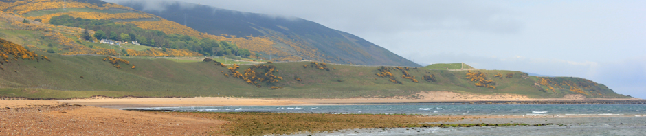
As the morning progresses, people begin to appear. Looking eastwards, squinting into the morning sunlight, I see Selsey Bill and the distant look-out tower, where I walked yesterday. Cormorants are perching on the warning markers at the end of the groynes.

Walking along through East Wittering, dog walkers appear and I see a cyclist wobbling towards me along the beach. His progress is interrupted by a groyne and he turns back.

Further on I come across a family constructing a maze. A circular pattern has been marked out on the sand and people are scooping shingle up with buckets and then ‘pouring’ it along the lines of the maze.

Higher up the beach, a girl on a large horse passes me, trotting eastwards. Later, I see her again, cantering back, this time along the edge of the waves.

There is a mass of land out to sea – I can see white cliffs with high land beyond. I am pretty sure this is Bembridge on the Isle of Wight. Bright sailing boats pass to and fro in the water.
 Ahead, I can see a cityscape, hazy in the distance. There is an unusual structure, towering above the other high-rise buildings. I recognise this – it is Portsmouth’s Spinnaker Tower. I would very much like to visit this amazing building. It has panoramic views and a glass floor to the viewing gallery – not for the faint hearted!
I have passed through East Wittering and am now walking across a wide, sunny stretch of beach. People are everywhere – sitting on the sand, erecting windbreaks, riding bikes, building sand castles, running down to the water, paddling and swimming. It is a beautiful day and I revel in the scene – this is the first weekend of the school holidays and an absolutely perfect English summer’s day.

 Among all the holiday makers, I see a couple of serious walkers striding across the beach. One man has a huge rucksack and looks like the sort of person who would cover 20-30 miles a day. The other has some interesting floral shorts and very muscular legs (maybe he is a cyclist too), with a dog in tow.
With over a year of walking behind me, I feel almost like a professional walker these days. But I still travel very light – with my small green rucksack. Today I am wearing ordinary trainers, not walking boots. Compared to these guys, I am an amateur.
This beach seems to go on for ever. Having curved around, I no longer see Portsmouth ahead but, instead, see a creek with small sailing ships. That must be Hayling Island.

Then something odd happens. A group of white-clad children appear at the top of the beach and run down, shrieking, towards the sea. I think they are wearing pyjamas. How very odd. The children don’t stop at the water’s edge but run, splashing, into the sea. The shrieking is even louder now. Adults, also in white pyjamas, run after them, shouting at them to stop.
Eventually, the children are retrieved from the water. They all line up on the sand, facing two of the adults, bow to each other and kneel down. I realise it is a martial arts group. Maybe judo. Or karate.

Just when it appears that order is restored, the lineup is disrupted by an excitable dog, who bounces into the group and prances around among the children. A man, shouting ineffectually, runs into the line up and chases the dog. Everybody gets tangled up in this game of tag, until the dog is eventually caught and dragged, reluctant, away from the children.
At the end of the beach, a long finger of dunes pokes into the estuary. This shifting mass of sand is called East Head and belongs to the National Trust. In today’s sunlight, against the blue sea, it looks beautiful. There is a car park near by. People are arriving. Barbeques are being lit. Picnics are in progress. Everybody is having fun.

I decide not to walk to the end of the dunes. Time is pressing. Instead, I walk across to the landward side. Here there is an area of salt marsh and I pick up the footpath that leads along the shore line towards West Itchenor.
This part of the walk is lovely. I walk across flower filled meadows, through wooded areas and by the side of an area of wide mud. The only downside is the sheer number of walkers I meet. Some people are on cycles (despite the fact cycling is not really allowed).


I look over Chichester Harbour – a wide bay with many estuaries, mainly mud except at high tide, but with deeper channels where sailing ships pass to and fro. There are lots of small dinghies out today and races are going on.
I pass through a small village called Rookwood – a hamlet really, just a few houses. The path deviates from the shore because of private property. Then, back on the shoreline again, passes along the bottom of gardens belonging to very fine houses.
 Suddenly, the path is forced between two high fences. The fences are cleverly constructed so that the gaps between the wooden slats are covered by a second layer of internal slats. The wood is new. I feel constrained and somewhat claustrophobic in this narrow space.
2/3rds of the way along, I come across a pair of gates – one on each side, so the owner of the property can pass through his high fences and cross the footpath. Through holes for the locks, I can see what lies on the other side of both fences. To the seaward side, is a hard dock area with some boat launching equipment.
 On the landward side is a very nice house. It looks new. It’s huge. And the owners obviously feel that those of us who use this footpath should not be allowed to get any view of any part of their property.
Because these high fences make me feel very indignant, I couldn’t resist taking a photo of the very thing the owner was trying to hide. Here is a view of this lovely house, taken through the hole where bolt is fitted in the gate.
I know landowners don’t like the idea of footpaths through their gardens. But the other properties along here, equally grand, take a more relaxed approach. So, to whoever put these fences up and ruined this section of the footpath, shame on you.

The footpath goes leads into West Itchenor, where I meet my husband for a very nice lunch at the pub.
Then, I walk down to the quay and out onto a jetty, where the map shows a Ferry P (a passenger ferry) crosses over the water to the hard at Smugglers Lane, Bosham. Although I could walk around the estuary from here – it runs in a long finger up towards Chichester – I have decided to avoid this unnecessary detour. In any case, I love catching local ferries.
 The ferry is a perfect little minature ferry-boat and can take bicycles as well as passengers.
The journey across the narrow channel should only take a few minutes but takes a little longer. Partly because we have to weave in and out of moored boats and moving sailing ships, and partly because we deviate to drop people off at their boats. First a man, who jumps out the back of the ferry and into his rubber dinghy, taking the rest of us by surprise because we weren’t expecting it. Then a father with his three children scramble off the ferry and onto their sailing boat. The children are young (aged between 5 and 10), wear life jackets, and seem remarkably at ease leaping from one craft to another.
 As we approach the hard at Smugglers Lane, we see a group of people – walkers and cyclists – waiting for the ferry to arrive. There is a hard pathway through the soft mud, leading to the ferry embarkation point.
The Itchenor Ferry has run since the 17th century and operated 24 hours a day until the 1960s, when the ferryman applied to the House of Lords to allow the ferry to stop running. A seasonal service (summertime only) was reinstated in 1976.
 From the hard, I walk along the shoreline, following the footpath. This is another lovely walk, through wooded areas and along grassy banks, less crowded than the walk to West Itchenor.
I round a bend and see Bosham ahead. This is a very pretty village. I have friends who live here and decide to drop in and see them.
Not used to arriving by foot and from this direction, I am a little disoriented and wander around until I find their driveway. They aren’t here. The house is shut up.
 Disappointed, I head into the main village. I walk along a road that floods at high tide. The tide is coming in, but has yet to reach the tarmac.
I stop at a cafe. My heart is set on tea and cake. Unfortunately, half the population of West Sussex seem to have the same idea and there are no seats. Next, I find a pub. Yes, they do tea and cake. And they have a lovely little balcony overlooking the water. Unfortunately, I drop my camera on the hard floor in the bar and jam the focus. I don’t realise this until later.
On the balcony, in the sunshine, I sit and enjoy a good cup of tea, watching the tide come in. Then I realise I may get cut off. Will the footpath be passable at high tide? I don’t know.
 I leave the pub in a hurry. People have put chairs out on the shore and there are still cars parked on the low-lying roadway. The tide is coming in at a pace, you can see the water growing closer to the tarmac. I wonder if the visitors realise and move their cars in time.
 I walk through Bosham and set off along the footpath. It runs around the bottom of gardens, below the walls. From the deposits of seaweed above the path, I realise the path is below the high tide line. I keep an anxious eye on the sea, creeping closer.
I leave Bosham behind and see the ‘mainland’ ahead. I would have really enjoyed this part of the walk, apart from my fear of the tide coming in and flooding the path.
I reach the end of the footpath, still dry. Now I walk through a field to the road. On the other side, according to the map, there is a track leading up to a lane and this is where I have arranged to meet my husband.
But I can’t see the track. How strange.
Then I see a man walking his dog. He turns off the road, walking through long grass. I follow him and find the track. It is an old road, now disused. Tall grass has grown up on the verges and hidden the tarmac. At the top of the road is my husband, waiting patiently.
This was a fantastic walk – beautiful weather and varied scenery. A great day! I believe, when the tide is high, sections of the footpath become covered in water. If you are planning this walk, make sure you know the time of high tide.
Miles walked = 11
High points = Beach walking to East Head and Ferry P at West Itchenor
Low points = breaking my camera
Route:


 At the end of this, I come to a kissing gate and an omninous sign. “Beware of the Bull”.


 The young bar man tells me there are plenty of places to eat in Lymington. I consider buying a bag of crisps but decide to continue onwards and find a proper meal.


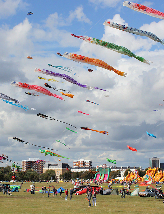
 Southsea Common is awash with bright, floating kites and balloons. There is a fun fair and entertainments. Later, I find out that Portsmouth is hosting an


")
")


 Ruth's coastal walk, Emsworth.")
 Ruth's coastal walk, Emsworth.")
 Ruth's coastal walk, Emsworth.")


