48. Lydd to Rye to Rye Harbour

This morning is wild and very, very windy. My husband drops me at a roundabout in Lydd. I am three miles from the sea and have a long inland walk ahead of me.

Skirting round the military camp, Lydd, Ruth's coastal walk.Before setting off this morning, I was beset with indecision. I stopped my last day of walking at Lydd and I have to start my walk today from the same place, Lydd. My mission, to walk as close to the coast as I can, would suggest I return to Dungeness and make another attempt to walk along the shingle bank to Camber. But, there is no guarantee the firing range will be open and, if I can’t make the walk along the shore, I will be forced to walk all the way back to Lydd just to get round the ‘danger area’.

Sometimes I wish I hadn’t created so many rules! But, if I am claiming to walk around the coast, then cutting out sections because it is too difficult is simply not an option.

Lydd, path to Camber and Rye, Ruths walk around the coast, UK.So, I walk through Lydd, past the army camp, heading for the B2075 for Camber and Rye. There is a cycle way that runs along this road and I hope the walking will be safe and easy. I walk across a wide area of common land and notice the grass is brown with dry, bare patches – as though it was the end of a long, hot summer – not late May.

The cycle way is new, smooth and runs along the road, but separated from the traffic by a screen of bushes and tall grasses.

Out in the open, I experience the true force of the wind. I am really, really glad I haven’t tried to walk along the shingle today. If I found it difficult and tiring yesterday, it would be doubly so today.

Pylons from Dungeness Nuclear Power Plant, Kent, Ruth's coastal walkThe cycle track passes under the line of pylons, carrying electricity from the Nuclear Power Station at Dungeness. The pylons fizz and crackle with their electrical charge. I stand, buffeted by the wind, enjoying the noise and the exhilarating sensation of being close to such immense, and lethal, power.

Suddenly there is a screech of brakes and a young lad on a cycle skids and swerves to avoid me. I am irritated. Young rascal. Then he says, very politely, ‘I’m sorry. It was my fault.’

As he cycles off, I consider my instant and unfair reaction. It wasn’t really his fault. He was cycling along the cycle path, probably head down struggling with the wind, and came across a middle-aged woman standing in the middle of the path, looking up at a pylon. It was, obviously, not his fault – it was mine.

Lakes near Lydd, Kent, Ruth's coastal walk
The path winds along, with the road and military range beyond on one side. On the other side is a view across windswept lakes and farmland. In the distance I see quarry works (I believe these lakes are the result of gravel extraction) and, nearer the coast, a wind farm. There are birds on the lake, including wind-blown swans, heads tucked protectively under their wings.

I pass Lydd Caravan Park, where static caravans are parked around and beneath the hissing, sizzling pylons. A sign declares units for sale, under the heading ‘Do you want the quiet life?’. I am not convinced, listening to the crackle of electricity and the whistling of the wind, that this is the best-selling point to feature.

Sheep sheltering from wind, Jury's Gap Sewer, Ruth's coast walk.
Further along, I come to a pile of old hay bales, piled into a stack. A group of sheep and their lambs are around the bales. At first I think they are eating. But the bales are old and are not there for nourishment. They are a wind break. The sheep see me approaching and begin to move away. As they leave the lee of the bales, the wind catches their fleeces and tugs their wool into wild shapes.

Kent - Sussex border, near Lydd, Ruth's coastal walkI come across a signpost on the cycle track and realise I am on the border of Kent, about to cross over into Sussex. Another county and another milestone on my walk.

The cycle track changes, instantly, at the junction between Kent and Sussex; smooth tarmac gives way to rough gravel.

Cycle track, Lydd to Camber, Ruths coast walkRound the corner and I meet a couple of cyclists, heading towards me. Their tyres bounce and skid on the gravel. How do they get to Dungeness? I explain they have to go to Lydd and turn right. The girl looks fed up and remarks it will be difficult cycling back against the wind. I tell them there is a pub in Dungeness. This seems to cheer them up. Later, it occurs to me that the last leg of their trip – from Lydd to Dungeness – will be against the full force of the gale. I wonder if they make it.

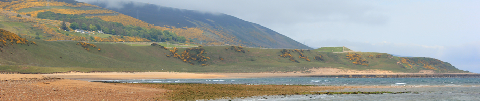
As I approach the sea, the wind gets worse. The road reaches the coast, at a place on the map called Jury’s Gap, where a few windswept houses huddle together. I climb up onto the sea wall. It is great to be back on the shore, but the force of the gale takes my breath away. I am truly glad, in retrospect, not to have attempted the walk along the shingle from Dungeness to here.

I look along the bank to the East and see, beyond the firing range, the hulk of the nuclear power station looming, dully, in the distance. The sea is grey, the waves high, the surf beats and lashes at the shingle.

Jury's Gap, East Sussex, Ruths coastal walk.

Looking along the coast to the West, I see a cheering sight. There are kitesurfers out. Their bright kites bob along the shore. And here are windsurfers too, scudding furiously over the waves. People are standing on the bank, watching. This area is famous for kitesurfing and people come from miles around to participate or to watch.

Kite Surfing, Camber Sands, East Sussex. Ruth's coastal walk.

As I get closer to Camber, the number of kitesurfers increases. Cars are arriving and young men are unpacking equipment. Women and children huddle on the beach. The wind is ferocious.

The speed of the riders – and the height they achieve as they launch themselves off the waves – is amazing. They need skill and physical strength. I watch as a kiter tries to beach himself. He launches himself towards the unforgiving shingle, leaping off his board as he approaches shallow water, and struggling to control his kite to which his body is harnessed. As he wrestles with the lines, trying to pull the kite in, his board is caught in the undertow of the waves and begins to be dragged out to sea. He runs after it and steps onto the board – trying to pin it down – while his body is wrenched to and fro by the force of the kite above him. Eventually, with the board tucked under his arm, and with a great deal of splashing among the huge waves, he manages to force the kite down onto the beach.

There see no women kiteboarding today.
Camber Sands, Sussex, Ruth walks the coast.
Leaving the kiteboarders behind, I approach Camber. Here the tide is going out, exposing an expanse of wide sands. There are some rather nice houses lining the beach. I head for a cafe and have lunch – overcooked fish and the ubiquitous chips.

When I emerge, the sea is far away and the exposed sand is being whipped inland by the winds. My plan was to walk along the sands until I met the mouth of the River Rother, and then to walk along the dunes, heading inland along the river and into Rye. After several eye-fulls of sand, I change my mind. Even with glasses on, I can’t walk into the wind.

Stonechat, near Rye, Ruths coastal walk. So, I turn away from the beach and walk along the cycle path, once again, leading me towards Rye.

I pass a golf club, with golfers straining against the wind, before finding a footpath that runs across fields, through sheep, towards the town of Rye.

On the way, I see this pretty bird with a pink breast. It looks a bit like a robin, but has a longer tail and black head. I photograph it and, later, with the aid of the RSPB bird identifier, I find out is a stonechat.

Rye, Ruth's coastal walk through East Sussex.
Rye looks lovely in the afternoon sunshine, breaking through the clouds. As I approach, a fun fair is in full swing. I walk through a park and traffic-jammed roads, heading for the bridge that will take me over the river.

I find a little flower shop that doubles as a cafe. I order coffee and have a cake. When I walk in, people stare at me. I wonder if they are looking at my boots, my jaunty little rucksack, or admiring my general air of health and wellbeing. After a very good lemon curd bun (although I did order banana cake), I visit the loo and find out, by looking in the mirror, that my hair is sticking up on end and covered in sand. I look like a wild woman. Or a scarecrow.

Motorbikes in Rye, Sussex. Ruth's coastal walk
The car park in the centre of Rye is full of motor bikes. I don’t know how they cope with the wind, but it is less obvious here, in the shelter of the town. The river is pretty and the old part of Rye has cobbled streets and historic buildings. There are a large number of tourists milling about, I hear French, German and Dutch being spoken.

Ostrich Farm, Rye Harbour, Ruth's coastal walk, East Sussex.But I don’t have time to linger and explore Rye. My destination today is Rye Harbour, on the west bank of the river and close to the sea.

I walk along the road to Rye Harbour, through an industrial estate. One of the many interesting things I see, is an ostrich farm. The ostriches look at me, through the mesh of tall fences. Their eyes are enormous. But their brains must be tiny.

Further along, I smell a wonderful scent – curry spices. I am passing a spice grinding facility. Bring your spices and have them ground here!

Chemical works, solvent recycling factory, Ruth's coastal walk, Rye.There is a huge industrial complex belonging to Solvent Resource Management Limited. I hear the sound of machinery operating, despite the fact this is a bank holiday Sunday. Later I learn this reprocesses waste, particularly organic solvents, and has close links to Ketton Cement – an industry based only a few miles away from where I live.

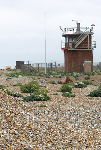
As I approach Rye Harbour, I note the church and the lane down which I will resume my walk tomorrow. But I carry on to the car park at the end of the road. Here is a ruined Martello Tower, surrounded by a high bank but recessed inside it – giving the impression of a castle keep surrounded by a dry moat and high bank. This is odd and I have not come across another Martello Tower with this external structure before. I wonder if the high bank is to protect against flooding.

Sitting on the bank, by the tower, waiting for my husband, I look at the boats moored in the harbour on the river. The river is very narrow and the ships are pleasure crafts, not working boats. Across the water, seemingly very close, I notice the golf course. Yes, it is the one I passed earlier. I have walked a long way to arrive back at the mouth of this river.

Despite the wind, the dark clouds, the whipping sand – today has been a great day of walking and I have made progress. Tomorrow I am heading for Hastings.


Vital stats: miles walked = 12, new blisters = 0


To get a feel for the excitement of kitesurfing, take a look at this video:

Posted in 05 Kent, 06 Sussex | Tagged , , , , , | 11 Comments

47. Dungeness to Lydd

Walkway across shingle, Ruth's coastal walk, Lydd-on-Sea, Kent.I walk along wood planking, across the shingle and down to the beach at Lydd-on-Sea. The sky is dark and threatening. The wind is strong.

Two ladies, wrapped up against the chill of the wind, are sitting on the end of the wooden walkway. Two men (their husbands?) are out on the exposed muddy beach, digging for bait.

Nobody else is here. My footsteps are the only ones on the sand.

Looking for bait, East Road beach, Lydd-on-Sea, Kent. Ruth walks the coast.As I walk along the beach, the tide is down and there is a wide expanse of flat, muddy sand to walk on. I feel invigorated, full of energy, ready for the day ahead. In the distance I can see the tip of Dungeness. Behind me, hidden by haze and low cloud, is the wide sweep of the bay, back to Dymchurch and Hythe. I imagine, although I can’t see, the long promenade and Folkestone beyond.

Dead fish and crabs on beach, Lydd-on-Sea. Ruths coastal walk.As I walk, in the area between beach and shingle, I notice a dead fish. Then another one. Then another. Every 3 or 4 yards, I find a dead fish. And smashed up crabs.

I wonder if a fishing vessel has unloaded catch it is not allowed to keep – fish that are too small and have to be dumped overboard? But then I decide it is the power of the waves, killing the fish by pounding them in the surf against rough shingle. I don’t know for sure.

As I head south, heading towards the misty tip of Dungeness, the strip of exposed sand on which I am walking becomes narrower.

From time to time, I hear the chuffing and tooting of the little steam train. A few minutes after the toots, I get the whiff – slightly acidic in the back of my nose – of steam and coal and oil. Then the air clears again, as the wind whips around my face.

After a little while, I look back and realise the tide has come in, covering the sands up to the shingle, all along the beach I have just walked on. In less than an hour, the sea has flooded in, silently, behind me.

With no firm surface to walk on, I head inland across the shingle. As usual, walking on dry shingle is hard work. Every step I take forwards, results in a downwards slide backwards. I have to work twice as hard to make any progress. My legs ache.

Dungeness buildings. Ruth's walk around the coast. Kent.

Dungeness itself is a weird place. There is shingle everywhere, as though we are on one enormous, endless beach – and I suppose we are. Although this is a designated National Nature Reserve, people live and work here. The houses are, in the main, made out of wood and single story. Many of them have boats lying alongside. Some homes appear to be old railway carriages. Everything is higgledy-piggledy. Telephone cables loop between poles that criss-cross the spaces between buildings.

This is not a wealthy place. These are not luxury holiday cottages.

Train going through Dungeness, Ruths coastal walk. The road winds through the houses, heading for the power station at the tip. And along the road runs the railway track. When I walked to Lydd-on-Sea from Littlestone-on-Sea, I had heard the little steam train before and had caught a glimpse of it. So I am expecting a small engine and ‘toy’ carriages and am not taken by surprise when the tiny train passes me – with much tooting and chuffing – heading for the tip of Dungeness.

Boats and huts on beach, Dungeness. Ruth's coastal walk.

Along the shingle, close to the sea, are fishing boats, shacks, and an odd collection of rusting machinery and old railway tracks, leading out to sheds. A working place.

Large light-house, Dungeness, Kent. Ruth's coastal walk.Lighthouse and power station. Ruth's coastal walk, Dungeness. There are two lighthouses at the end.

The new one is enormous. I am dizzy looking up at it.

The second lighthouse is older, smaller and no longer functioning. The Old Lighthouse remains a Grade 2 listed building, open to the public and available for weddings.

I am no longer the only tourist here. Cars arriving with people coming out for this bank holiday Saturday, braving the blowy weather. People walk and take photographs – of the shingle vegetation, of the lighthouses, of the sea.

Dungeness Nuclear Power Station, Ruth walks the Coast, Kent.And above us all, ahead, is the power station. This is a fully functioning nuclear station. It doesn’t have the charm of Sizewell – the buildings are too flat and squat. It is missing the wonderful dome. But it does irradiate a feeling of immense power.

I stop at the only pub in Dungeness, where I plan to meet my husband for lunch. The place is quiet. Then a train arrives at the little station close by. Cold, windblown people head for the shelter of the pub and the place is soon full.

After lunch, I set off, heading around the perimeter of the power station. My plan is to walk along the coast, following the shore, from here to Camber Sands and then on to Rye.

Alas, things do not go according to my plan.

Crashing waves, Dungeness coast. Ruth's coast walk.When I get past the shelter of the power station, and climb up to the top of the bank, I experience the full force of the wind. It threatens to knock me off the bank. I struggle to keep my foothold in the loose shingle. Luckily someone has driven a vehicle up here, and the stones are somewhat impacted, making the going – although difficult – not impossible.

On the beach, huge waves crash and break against more shingle. There is no sand on which to walk.

Buffeted by wind, and fighting for a foothold on the shingle, I continue onwards. Only 5 miles of this, and I will reach Jury’s Gap and – if the map is correct – I will find sand to walk on. In the meantime, the only sand around is being blown at me, horizontally, getting into my eyes, my nose, my hair, even my ears.

Watchtower, Range, Dungeness. Ruths coastal walk.Ahead of me is a military watchtower. I have been looking for this. I am about to enter a firing range. Apparently, the range operates 300 days a year. I am hoping it will not be used today, being bank holiday weekend.

I don’t know for sure. Hythe Community Web site provided information about the opening times of the Palmarsh ranges. But a Google search did not turn up any specific information about times for the Lydd firing ranges at Dungeness. I did find an MoD link and rang their out-of-hours telephone number the previous night. But nobody answered.

So, I am on the lookout for red flags and lights.

The watchtower appears empty and I can see no lights. But there is a flag. A red flag. A definitely red flag, fluttering madly in the wind. But is it a ‘real’ red flag? Or just an old flag left carelessly on the platform? How can I tell?

I sit down on a large rock and consider my options. If there is live firing on the range, I cannot continue along the shore. The ranges are placed so that artillery fire and rifle shots are aimed over the sea. I am nearly being blown off the bank. I don’t want to be blown up too.

Looking at my map, I cannot see a clear right-of-way inland. But there are a few footpaths and ahead, only half a mile inland, is a track that I may be able to walk on and this leads me to a circuitous road. After dithering a little longer, checking and re-checking the map in the hope that a new red dotted ‘right-of-way’ line will mysteriously appear, I set off across the strange shingled surface of the Dungeness nature reserve. The shingle here is rather ‘dirty’ looking, darker grey surfaces on the brown/grey stones. There are clumps of bushes and grasses. In some places, the shingle is covered by thick plants, like matting, creating a soft carpet to walk on.

But the shingle, undulating gently and covered in low plants, is utterly featureless. Far ahead I can see a water tower and a church. But I can’t make out, on my map, what the tower is and which church I am looking at. I feel disoriented and uneasy. I have the dangerous firing range on one side. A nuclear power plant with fierce warning signs on the other. A howling gale blowing behind me. And ahead is a protected nature reserve, across which I am not supposed to wander freely (signs advise sticking to the paths).

Reluctantly, after tramping around for a while, and getting very dusty, I retrace my steps past the nuclear power station. As I return, I notice an illuminated sign board within the nuclear site. The sign proclaims in red lights, as if it is some wonderful feat, ‘26 event free days’. Hang on! What happened 27 days ago? What do they mean by an ‘event’?

Then I trudge back to the pub, back to the lighthouse. From here, definitely marked on my map, a footpath sets off across the Nature Reserve, heading for Lydd.

I am reassured. But really my troubles have only just begun. The path is marked. But only just. Intermittently. Halfheartedly. In fact, the signposts consist of short poles, sticking up above the ground by 1-2 feet. This makes them impossible to spot from a distance. And the footpath leads to a narrow strip of land, running across a large lake. If I miss the strip of land, I will have to walk round the whole lake.

To add to my worries, the shingle here is extremely deep and very, very loose. I feel I am walking in deep mud. Or walking through a trench of soft snow. My boots slip and slide. My knees ache. Dust, tossed up by my footsteps, blows around me, coating my boots and trousers in a grey film. Part of me reassures myself – I can always turn back. But after a while, I know I can’t. I have come too far. It is 4 o’clock in the afternoon. I have already spent 3 hours trudging around Dungeness. I need to press on.

The trail seems frighteningly illusive. I keep the Old Lighthouse directly to my back. I watch for the footpath markers ahead – I can only see one at a time. I keep walking. Lakes, Denge Beach, Dungeness. Ruth's coast walk, Kent.Just as I am about to give up, and decide to strike out for the road I can see running to the north, I spot the strip of land. It crosses the lake, taking me towards Lydd. And, blessed relief, it is remarkably shingle free.

Dead bushes, Denge Marsh, Ruth's coastal walk, DungenessSafely across the lakes, I walk through a field full of sheep and strange dead bushes. I join the road by Boulderwall Farm. Now I have a two-mile trek into Lydd, following a road with no pavements. Luckily traffic is light and I make good progress.

I text my husband and ask him to pick me up from the roundabout in Lydd.
“Don’t you mean Rye?” he replies.
“No.” I reply, shortly.

Later, when I look at my map again, I realise I have only really travelled 3 miles today – and they were all inland, not along the coast.

But, I have spent several hours trekking through some of the weirdest scenery in England – rare plants and an exotic landscape – all in the shadow of a great nuclear reactor. What more did I want?


There is information on Wikipedia about the Dungeness Nuclear Power Station.
You can find out more about the lighthouses of Dungeness on the Trinity House website. Trinity House is the General Lighthouse Authority for England and Wales (and the Channel Islands and Gibraltar too – to be strictly accurate).

Vital stats: miles walked = 13 miles – but none in the right direction!


Posted in 05 Kent | Tagged , , , , | 10 Comments

Stage 46. Hythe to Lydd-on-Sea

Today will be long and tiring. I don’t know this yet, so I set off in good spirits.

I walk along the Hythe promenade until it ends. There is a boat yard ahead. Well, not exactly a yard, more a section of beach with boats on it. Signs warn me of dangers. I can’t see a footpath, so I walk through the boats, jumping over ropes, and reach the beginning of Palmarsh Ranges. Ahead I can see a couple of Martello towers.

Martello tower guarding entrance to range, Hythe. Kent.The way is blocked by more warning signs. This is an active, military firing range. I have checked on the Internet and there is no shooting planned today. I am relieved, all the same, to see no red flags or warning lights.

I would like to walk on the beach, but the tide is high and I am forced to walk on difficult shingle. Further along, the shingle is covered by waves and I end up climbing over groynes and over rocks. It is going to take me a very long time to get to Dymchurch at this rate. And I was hoping to get to Dungeness today.

I begin to reappraise my plans for lunch, when I see a man walking on the bank above me. I scramble up the shingle and realise there is a track running along the beach. After this, I make good progress. Apart from the one solitary walker (who passes me, heading for Hythe) I see nobody else until I reach Dymchurch Redoubt.

The firing ranges fascinate me. They are clearly positioned so that you fire from inland with the bullets whizzing out to sea. I like seeing the huge numbers ‘1’, ‘2’, ‘3’ and so on, silhouetted against the sky. Surreal.

Beach and Palmarsh range, Hythe. Kent. Ruth's coast walk.

Later on, I pass signs telling me not to take photographs. I obey. Of course.

In the distance, I see buildings reminding me of a set on a Western film; the fronts are painted to look like terraced houses in an ordinary street, the backs are just unpainted plywood. There is a SUV (I have no idea if it is real or not) in the ‘street’ and some obstructions that mimic road blocks. I also see the grey roofs of a small housing estate. But the estate is surrounded by very high walls and there are huge lights around the perimeter. I can’t work out if it is some kind of prison block, or another practice area for military training.

There is a third Martello tower on this section of coast, but the foundations have been undermined and the tower has toppled over.

Crumbling Martello tower, Hythe beyond. Ruth's coastal walk.

Fishermen near Dymchurch Redoubt, Ruths coast walk, Kent.I reach the end of the firing range and the end of the beach. There are a couple of fishermen, but otherwise this section of coast is deserted.

I have made good progress and wonder if I will make it to Dungeness today. For a few minutes, I rest beside a mast – probably a radio antennae – consulting my map and having a drink with a snack.

Continuing along the sea wall, making my way around a rocky outcrop, I come across a warning sign.

Danger, non-ionising radiation. Palmarsh Ranges, Ruth's walk.“Caution non-ionising radiation” and, more ominously, “Do not loiter within 2 metres of any antenna.” I look back at the mast where I have just spent 10 minutes of ‘loitering’. A bit late to tell me now! Why not have the warning sign actually on the antenna?

Later, I look up non-ionising radiation. It is not as terrifying as it sounds. I may have risked being cooked by microwave rays, but that doesn’t seem as bad as being exposed to nuclear radioactivity.

Dymchurch Redoubt - Kent. Ruth's coastal walk. I walk round the fenced off Dymchurch Redoubt . Mistakenly, I believe this is an old WW2 defence structure. Later, I learn this was built as part of the much older Martello Tower defence system – and was completed in 1812.

Having made my way round the seaward side of the Redoubt, along the slippery concrete skirt of the sea wall, I come to a wide slope leading upwards. Signs tell me I can only use the slipway in an emergency. Since there is no other way forward, apart from swimming, I ignore the signs and go up the slipway, climbing over a low barrier at the top.

Endless Promenade, Dymchurch. Ruth's coastal walk through Kent.I am standing at the end of a long promenade. Ahead of me, stretching into the distance, is a wide, new-looking, concrete walkway. This looks like easy walking. But also rather boring. And so it is.

I pass – and am passed by – a few dog walkers. Otherwise, not much happens. For mile after mile.

After a while, I walk on the landward edge. At least here there is something to look at. If I walk close to the wall, I can see over it. There are occasional steps up from the road beneath, and I notice the steps either start above the wall, or have flood gates in front of them. This promenade is part of newly competed sea defences. Further along, I discover some parts are still under construction.

Low lying Dymchurch, view over Romney Marsh, Ruth's coastal walk.The land seems very flat and low. Is it my imagination, or is it even lower than the sea? I look over a large caravan park. Beyond are flat marshes (Romney Marshes) and beyond that I see the ground rising up to form a ridge. At the base of the ridge, invisible from here, runs the Royal Military Canal, leading from Hythe to Rye. Along the ridge itself, runs The Saxon Shore Way.

For a moment, I wish I had stayed on the high ground and followed The Saxon Shore Way. The view up there must be more interesting than down here.

Lost dog notice on bench, Dymchurch - Ruths coast walk.The walkway is punctuated by benches, on which I see nobody sitting. But I do notice signs fluttering. Taking a moment to look at one, I realise these are ‘lost dog’ signs. I wonder how long they have been here?

Then another thought strikes me. All these signs (and I pass 10 or more of them) are hand written. Immediately, I picture an elderly person (clearly not a computer owner), laboriously writing out these signs and then pinning them, one by one, to the benches. How sad and desperate they must have been. I wonder if the dog has been found.

Martello Tower, Dymchurch. Ruth's coastal walk.Further along, I pass more Martello towers. One tower has been converted into a private house. Apart from the lack of windows, I imagine this is a fine place to live. Later, I see a tower that actually has a large gun on top, as it was originally designed to have. I don’t know if this an original, or not.

Deviation sign, Dymchurch, Ruth's coastal walk.
At this point, I am forced to detour off the sea wall, due to ongoing construction projects. I walk down a road, before finding another footpath to rejoin the coast again.

The promenade here is gleaming new, so bright it almost hurts my eyes.

New sea wall, Dymchurch. Ruth's coastal walk through Kent.

The defences are impressive. There are groynes in the sea – the tips of the wooden structures just visible below the waves. The stepped base of the wall leads up to a lower walkway with a high, curved wall (designed to reflect back the waves and minimise undermining of the structure) and a higher walkway above this, with a further wall beyond. This is part of our ongoing battle to contain the sea and preserve the shore.

I remember the twisted remains of sea defences in Norfolk – particularly poor, sad Happisburg. I wonder how long these will last.

Donkeys on Dymchurch beach, Ruth's coastal walk.The sea front is beginning to liven up. The weather is fine, although the sun pops in and out of clouds. People are arriving for a day at the beach.

I notice a trailer parked on a slipway, with donkeys patiently waiting alongside the vehicle. The tide is still high, too high for the trailer to get down to the beach. They have to wait for the tide to go out. Later, I suppose, there will be donkey rides along the sand.

A woman on a motorised disabled scooter is moaning to one of the women in charge of the donkeys. She, too, is waiting for the tide to go out, so she can take her scooter down the slipway and onto the sand.

Dungeness nuclear power station, from St Mary's Bay, Ruths coastal walk.I walk faster now. I realise I am not going to make Dungeness today. My feet are aching and I am growing tired.

Ahead of me, across a bay, I see the outlines of the structures of the nuclear power station. So tantalising close. But just too far away to get there today.

I am walking through a place called St Mary’s Bay. I hoped to stop here for lunch, but there are no pubs (or anything else much) on the sea front. I don’t want to walk through village streets, searching for a pub, so I decided to carry on to Littlestone-on-Sea.

Littlestone-on-Sea from St Mary's Bay, Ruth's coastal walk.Ahead I can see a tower and, looking on the map, I realise the tower is on the outskirts of Littlestone. This acts as a marker – a beacon – for the next part of my walk.

The sea wall grows narrow. Nobody is walking here. A mother and son pass me on their bicycles. They turn round and come back. I walk. And walk.

I see signs for a hotel and am hopeful for lunch. The wall runs alongside a private road – a track really. After a long while, I pass a grand house. It has a sign advertising functions, such as weddings, and cream teas. This must be the ‘hotel’. How disappointing. No lunch yet!

Further on, and I pass large houses in various stages of decay or renovation. There is run-down feel to this area.

Water Tower at Littlestone-on-Sea, Ruths coastal walk.Then I spot the tower. It looks like an old Victorian water tower. (Later I read a post on the Kent History Forum site, indicating the tower was an expensive mistake, as the water was too salty for use. In any case, plans to develop the area into a thriving seaside resort were never fulfilled.) The tower is being used as a residential house. How wonderful!

My husband. Supporting Ruth's coastal walk.Further on, I am growing very tired. The beach is shingled. There is a motley collection of beach huts and small boats. The sea wall becomes a rough bank and my feet hurt on the uneven ground. I see no sign of a pub. My heart sinks. It is after 2 pm and I don’t want to walk any further.

Then my husband texts me. He is on his bike and has found a pub ahead. It is a little run down, practically empty, but sells food all day. And I can get to it from the sea wall.

Littlestone-on-Sea, Kent. Ruth's coastal walk.

After a good lunch, and a couple of glasses of cider, Littlestone-on-Sea looks much more attractive. And I have my energy back. I decide to walk on to Lydd-on-Sea, where my husband will pick me up from the car park.

The tide is going out. I walk along the shore, close to the waves. A steep shingle bank rises to my right.

Throughout this section of the walk, I hear the sound of the trains running on the small railway track and see the occasional puff of black smoke above the shingle. At one point, in Greatstone-on-Sea, I make my way back off the beach, up to the road and watch for the train to cross over a nearby level crossing. There is a great noise of steam and approaching machinery. When the train finally whizzes over the crossing, it turns out to be a tiny little train, a toy train really. I am amused. In my mind, I was expecting a big steam monster of a train.

I walk along a sand bank, cutting across the bay, making good time.

Down here, below the shingle bank, it is hard to tell where I am. I check my iPhone app and take GPS readings. When I am parallel to Lydd-on-Sea, I fight my way up the shingle bank and find the car park.

This is the edge of the Dungeness nature reserve – Europe’s largest area of shingle beach – a rare and fragile habitat, home to many unusual plants and insects. The next section of my walk will take me into the heart of this unique landscape. I can hardly wait.


To see some great photos of Dymchurch Redoubt, visit the Underground Kent Website.

Vital stats: Miles travelled = 11


Posted in 05 Kent | Tagged , , , , | 2 Comments

Stage 45 Dover to Folkestone to Hythe

I said my last walk was ‘the best day of walking, ever’. I was wrong. Today is the best day of walking, ever. As we drive along the motorway, approaching Dover, the sun is shining and the air is clear. First thing I notice, when I see the sea, is the firm, definite line of the horizon.

“I wonder if we will be able to see France today?” I remark. “There is no haze.”
“Maybe,” says my husband, “but there is that island in the way.”
“What island?”

Then we realise. It’s not an island. We can see France. How many times have we driven to Dover to catch the ferry? And only once did we catch a glimpse of France. That was very early in the morning and my husband is convinced I dreamt it.

Dover sea front and castle behind, Ruth's coastal walk.I am very excited by a prospect of walking over the white cliffs of Dover, with France in view. How perfect!

I start from Dover seafront. Looking out, across the little beach, through the mouth of the harbour, I can see the outline of France. It looks so close. You could sail across and be there is a few minutes, or so it seems.

Walking along the promenade, I pass the end of the pier, over a bridge across the marina, and walk up the busy access road heading west.

This part of the walk is tedious, as cars and lorries roar past. I am relieved to find the footpath, branching away from the road, to the left. I walk in a tunnel of greenery. The traffic trundles past below. The path takes me steadily upwards and away from the road.

Below me are great views of Dover and I can see the harbour spread out, with the white cliffs of South Foreland (my route for the previous section of the walk) beyond. The sky is blue with great, fluffy clouds. The sea, multicoloured, sparkles below me. In the distance, I can see the blue outline of the French coast, with ferries and boats heading back and forth. I try to imagine what this area was like, thousands of years ago, when we were physically connected to France by dry land.

Ferries, going from Dover to Calais, Ruths coast walk.

White Cliffs of Dover, Shakespeare Cliff, Ruth's coastal walk.As the path climbs higher, I can see the motorway below me. But I have a view that is invisible to the passing traffic, a fantastic view of the white face of Shakespeare Cliff, with a little beach and railway line far below. As I watch, I see people swimming in the sea (although they don’t linger long) and a little train hurtles along the line, disappearing into a tunnel through the cliff.

The path is steeper and I begin to puff. I pass allotments, perched on the side of the cliff. Apart from one cyclist, heading for the beach below, I meet nobody.

Cliff edge, Dover. Ruths coastal walk through Kent.When I get to the top, the path has been diverted – away from the eroding cliff edge. Part of a fence sticks out, almost into the abyss. A broken sign warns me of the edge, rather unnecessarily I think.

Poetry, Dover cliffs, Kent. Ruth's coastal walk.

The path I am following is both the Saxon Shore Way and the North Downs Way.

Interestingly, as I continue walking, I come across little signs, each one indicating that there are poems written with this specific location in mind. I could listen to the poems by telephoning the numbers given on the signs. I don’t. I could be here all day.

But what a great idea! The Chalk Line Poems, by Ros Barber, can be read here or listened to here.

This is the highest section of my walk today. I can see the path ahead, stretching out across the cliff top. And beyond I can see Folkestone, below.

White Cliffs, Dover - towards Folkestone. Ruth's coastal walk.

Dotted along the route are strange round pillar constructions. Later, I learn they are ventilation shafts for the railway tunnel, passing below. Further along, I meet a handful of other walkers, but surprisingly few people out and about on this beautiful day. I pass over a newish park area, called Samphire Hoe.

WW1 coastal defences and Dover Harbour, Ruth's coastal walk.

Over the top of the next rise (after a scramble up a steep hill and a divergence away from the cliff because of crumbling edges), I pass remains of war defences. There is a marvellous view back towards Dover and the harbour.

View to Folkestone and Beachy head beyond, Ruth's coastal walk.

I can see Folkestone waiting below. Beyond is a flat spit of land, leading out to sea. On the end of this spit (not visible in the photo above) are some large rectangular blocks. I know this must be the nuclear power station at Dungeness. Further beyond, at the limit of my vision, I see more white cliffs, rising up above the flatness of Dungeness. Is this Beachy Head? I think it must be.

North Down's Way, coastal defences Dover, Ruth's walk.There are lots of interesting ruins here – left over from World War II. I meet a group of young men who seem intent on climbing down a dark shaft and into a tunnel, that they believe lies below. They have a large flashlight but no ropes. I doubt whether they will get far.

Spider Orchid, information plaque, Abbot's Cliff, Kent. Ruth coast walk.Further on, the ground opens out into a swathe of green grass. Somewhere below me, at the bottom of the cliffs, is a nudist beach.

The path becomes a track. This is Abbot’s Cliff. Here I come across a little plaque, telling me about the spider orchid. I have seen a lot of wild flowers on my walk today (the warm weather has caused premature flowering of plants), but I have no idea if I have seen a spider orchid or not. The plaque, being uncoloured, does not give me many clues.

In this area I see a large concrete structure with a tree growing out of it and covered in graffiti. It looks fairly new. I take little notice of it, but later realise it was one of the concave, concrete listening devices – a ‘sound mirror’, – used in the war to give early warning of the approach of enemy planes.

Ruth and John, East Wear Bay, lunch. KentAfter Abbot’s Cliff, I pass a wonderful white house in need of renovation, set in a huge garden, that forces me to turn inland. I meet a road, but a footpath takes me up to the cliff edge again. Now the path winds behind gardens and along an area of cliff that has slipped and is open to the public as a rather wild country park – called The Warren.

I am very high up. I see the pub at which I planned to have lunch. It appears derelict and some of the roof appear to be missing. Has there been a fire? I walk on.

My husband phones me. He has found a cafe, perched on the top of the cliff. We sit outside and have lunch – burgers and a cup of tea for me, soup and sandwich for him. The views are staggering. This is perfect. Much better than a pub.

White cliff, path down, East Wear Bay, Kent, Ruths coast walk.After lunch, I have a choice. Stay up on the cliff top, following the official coast path, or take a winding path down the cliff, to the beach below. A railway line separates the cliff from the beach, but I can see a bridge across the line. Hopefully, I can cross over. It will mean doubling back the way I have come.

I talk over the choices with a couple of fellow walkers, chance encounters on the cafe terrace. They elect to stay on the official path. I decide to head down to the sea.

The path winds down the slope, steep steps that zig zag down beneath a leafy canopy. I am alone. I soon lose sight of the cafe above. Bushes and trees arch across the path. It takes far longer to descend than I anticipated. Near the bottom I hear sounds, children are playing somewhere – I can see a rope swing in a clearing below. Further down still, and there are some tents, hidden in bushes. Young lads are breaking twigs, somewhere in the undergrowth. I don’t know if this is an official or an unofficial camp.

East Wear Bay, Kent - Ruth's Coastal Walk.I reach the railway line and follow the path, heading back eastwards, along the line, towards the footbridge. I hope this is accessible. As I approach, the path rises up a steep bank, away from the line and my heart sinks. Must I climb back up to the cafe?

But it is a false alarm. I can get onto the bridge after all.

As I cross, I stop to take photos of the railway line. To the east is the mouth of a tunnel. Strange, I think to myself, the tunnel appears to be lit up or I can see right through to the other side. There is light. Then, with a ‘whoosh’, a train emerges and rattles along the line, passing beneath my bridge and heading towards Folkestone.

East Wear Bay, Kent - Ruth's Coastal Walk.The beach here is empty and wild. There is a huge expanse of concrete at the foot of the cliffs – a large flat area that appears, superficially, to be a wide promenade – but is too unkempt. Later, I surmise this is part of the coastal defences to try to protect the base of the cliffs. The top has already slipped (forming ‘The Warren’ area above).

I head west, towards Folkestone. The concrete gives way to a beach. People are out, enjoying the late afternoon sunshine. There is sand here – mixed with shingle – but still sandy enough for children to build castles and dig for crabs.

At the end of the beach there is no way forward. The waves splash up against the rocks of Copt Point. A small path winds up the cliff and I head up, puffing slightly. Luckily the cliff is much lower here and I soon reach the top.

Martello Tower, Folkstone, Ruths coast walkI am on the edge of a putting green, perched above the sea. There is, incongruously, a Martello Tower in the middle of the green. I wonder if it is being used as a residential house.

I walk up the green, around the tower, and come across a proper promenade, bordering the sea, leading me down into Folkestone itself.

Folkestone is very pleasant. People are out, walking. I hear English, French, Spanish and other languages. There is a harbour with sailing boats, lots of mud (the tide is out now) and a strong smell of fish.

Folkestone, Ruth's Coastal Walk.

On the other side of Folkestone, is a wide shingle beach. The promenade stretches, unbroken, towards Hythe. Just above the prom, a new park has been created, Lower Leas Coastal Park. There are flowers, bushes, trees, children’s play equipment, chess boards, picnic tables and barbeque sites. I come across a large Spanish family, setting out tables and chairs for an evening meal.

This is a perfect evening. The air is warm. There is no wind.

Promenade to Hythe - Sandgate - Ruths coastal walk.

The park ends and I follow the promenade as it passes through Sandgate and on towards Hythe. Leaving Sandgate behind, there is nothing now but shingle. The light is growing dim, clouds cover the fading sky. The path stretches ahead. Hythe looks distant and I have the illusion that I am making no progress towards it. A few cyclists and joggers over take me.

Dungeness Nuclear Power Station, Ruth's coastal walk.

In the distance, at the end of low-lying headland, I can see the large bulk of the power station. This is Dungeness. I am heading there tomorrow. The land looks flat. The cliffs have gone.

Dave the Dolphin sign, Hythe, Ruth's coastal walk in Kent.As I approach Hythe, the light is too bad for photography. But I can’t resist this sign – warning us not to touch Dave the Dophin, who turns out to be a ‘she’. Although I keep my eyes peeled, I don’t see her.


Vital stats:
Miles travelled = 12 miles
Blisters = 2
Dolphins seen = 0


Posted in 05 Kent | Tagged , , , , | 16 Comments

Stage 44. St Margaret’s to Dover

St Margaret's at Cliffe, Kent, Ruths coast walk.It is Bank Holiday Monday. What is wrong with the British weather? It should be raining. Instead the sun is shining and it is unseasonably warm.

This is the best day of walking, ever.

I start off from St Margaret’s Bay, down in the little cove, where the light, coming from the East, lights up the chalky cliff.

Following the road upwards and then along a track, past a beautiful garden, where I walk behind a French family – a mix of adults of various ages and children, including a toddler in a push chair. At first I think they are heading my way – up the cliff, but they stop at a field where a camper van is parked. They are over from France to spend Easter weekend in the UK – and what a fabulous weekend they have chosen.

Now my walk becomes more difficult. The footpath branches off from the track and I scramble up a steep field to the top.

Approaching light house, South Foreland, Kent, Ruth's coastal walk.The view is somewhat disappointing. I cannot get close to the edge – warning signs deter me and an overgrowth of shrubs conceal the cliff and bay below me.

I am forced to walk on the landward side of private property. There are houses up here. I wonder how long they will survive (this cliff must slowly be eroding) and I am envious of their wonderful position and the great views the householders must enjoy. Views, at the moment, denied to me.

I am following a lane lined with trees. Ahead, I see a lighthouse.

Emerging by the Lighthouse, I lose my momentary bad humour. The landscape opens up and there are stunning views across the sea – the morning sunlight bounces off the water, far beneath.

Cyclists on cliff top, Ruth's coastal walk.

There is a car park by the lighthouse – this is National Trust property – and a car park means people. People are out, walking across the open land or standing, staring out at the sparkling sea. A group of cyclists have stopped on the cliff edge, drinking from their water bottles and enjoying a rest.

I later learn this is the South Foreland Lighthouse, one of two lighthouses designed to help ships avoid the treacherous Goodwin Sands. Unfortunately, with the shifting of the sands, the lighthouses became unreliable and the second lighthouse was decommissioned in 1910 and is now part of a private garden.

White cliffs, Dover, Kent, Ruth on her walk round the coast. The remainder of the walk, towards Dover, is truly wonderful.

I walk across rolling green countryside, keeping as close to the cliff edge as I dare. The path twists and turns. Every turn brings another fantastic view – towering white cliffs above dark rocks, framing the sea of sparkling blue. In the distance, a hazy horizon where the sea joins, seamlessly, with the huge, blue, cloudless sky.

Ahead, growing closer in the haze, I begin to see glimpses of the Port of Dover, stretching out from under the cliffs.

I come to an area where the ground drops down, forming a steep bowl. I believe this is called Fan Bay. It is possible to stick to high ground and walk around the edge of the bowl. This is what everybody else is doing. But I feel the urge to stick closer to the cliff edge, going down into the bowl and up the footpath I can see, climbing steeply, up the other side.

Going down into Fan Bay, Ruths coastal walk, KentIt will be a bit of an effort, but it looks fairly easy. I am encouraged by an older couple, making their way down ahead of me. And further encouraged by the sight of a man with a push chair coming up towards me. If they can do it, so can I.

The walk down is relatively easy. But the climb back up is, to be blunt, hard and exhausting. The other side of the bowl is much steeper than it looks. The ‘path’ turns out to consist of footholds in a grassy bank. There is nowhere to rest. The slope is too steep to sit down. I am scrambling on all fours – looking for footholds and hand holds. The steep drop below, and the glimpses of bright sea even further below, add to a vertiginous sense of anxiety. I am reminded of skiing and that black slope moment of terror when you realise that you don’t want to go on, but you know you can’t stop.

The older couple ahead of me are finding it difficult. The woman stops, clinging to the slope like a limpet. For one moment, I think she is frozen with apprehension and unable to move.

“Come on,” her husband calls. “There is a woman behind you.”
She flattens herself against the slope before looking down, nervously, at me.
“Don’t worry,” I call up. “I’m enjoying a breather.”

I intend this to sound confident. In reality, I am part grateful and part worried that she is above me. Grateful that I can use her as an excuse for stopping every two minutes. But worried because if she loses her grip and starts sliding down the slope, she will surely take me with her.

We are nearly at the top. The man is there already. Then his wife joins him. Encouraged, I scramble madly up the last bit and arrive on the path beside them, trying not to look as hot and flustered as I feel.

“We thought it would be easy,” he explained. “We saw the man with the push chair coming up. But he must have turned back. He couldn’t possibly have come down this way.”

No, he couldn’t. I don’t know how anyone could come down this way, you would need to be as agile and fearless as a mountain goat, or do it backwards – like coming down a ladder. And today the ground is hard and dry. In slippery, muddy conditions, this ascent would be truly dangerous.

Dover from cliff top, Ruth's coastal walk.From now on, the going is easy. I stick to the path.

As I draw nearer to Dover, the paths along the top of the cliffs become surprisingly crowded with a large number of walkers – enjoying the Easter sunshine. There is an absence of dog walkers. Perhaps the steep cliffs deter people from bringing their pets here.

Listening to people, I hear English accents, along with French, German, Eastern European and Asian languages.

I used to feel ashamed of Dover – such a horrible port with brutal infrastructure and access roads, carved into the white cliffs, with no attempt to showcase the iconic countryside. What a horrible introduction to England for new arrivals! Now this area has been opened up and access to the cliffs encouraged, this is a welcome change and a great way to greet tourists and visitors.

Ahead I see a groups of young Japanese people. They are lining up in front of a view-point, where the path curves and allows for photography against a back drop of the white cliffs. Next to them and, incongruous among this lively crowd, sitting in camouflage gear, is a lone figure. A bird watcher.

Bird watcher on Dover Cliffs, Ruth's coast walk.

She has a huge telephoto lens attached to her camera and is scanning the cliffs opposite. Unfortunately, the tourists (and as I watch, the crowd of Japanese disappear but are quickly replaced by a group of young Russians) must be deterring the birds. She ignores them all, fixing her attention on the cliffs.

Husband on Dover cliffs, Ruth's coastal walk in KentThe land drops away again, forming another bowl on the cliff top – Langdon Bay. This is National Trust property.

You would think I had learned from my previous experience. Everyone else sticks to the high land around the edge of the bowl. But, no, I feel the urge to go down. This bowl is bigger and has sheep tracks running through it.

On the way down, my mobile phone rings. It is my husband, with his mother, who have arrived at the view-point above Dover and are looking across the cliffs, hoping to see me. Looking up, I spot them.

“Well, I am hard to miss,” I say.
“There are a lot of people out today.”
“Yes, but I am the idiot below you.”
Two distant heads swivel round.
“What are you doing down there?”
“It seemed a good idea at the time.”

The climb back up is more gentle but still leaves me puffing and panting before I reach the top.

We pose for photographs together, then part company. My husband is going back to the car with this mother. I am walking on into Dover.

I start off heading the wrong way. A wide ledge in the cliff (was this a roadway at some stage?) leads me downwards, running alongside the vehicle approach to the Port, but ends in a narrow path that becomes progressively more overgrown. After forcing my way through bushes and crawling under branches, I come to the conclusion that this path is not the official public right-of-way. I emerge dusty, scratched and hot, retrace my steps up the ledge and find the correct route.

Underside of bridge, Dover Ferryport. Ruth's coastal walkThe footpath takes me down towards the town of Dover.

I pass under the access road to the Ferry Port.

How many times have we crossed over here – my husband and our family – dashing across and into the Port – on our way to some skiing trip or holiday in Europe?

I linger under the bridge – hearing the thunder of lorries above me and enjoying the surreal experience of being here with the huge concrete structure above my head, standing quiet and still in the midst of all this frenetic, noisy activity.

I walk along the busy road, by the waterfront, through Dover. There are signs for bike routes and footpaths, everywhere. So many, and pointing in such diverse direction, I find it difficult to know which route to take.

I meet a fellow walker, rucksack on his back. He started from Deal and plans to have lunch on the beach at Dover, where he took his grandchildren to play while waiting for the ferry. I can remember waiting for the ferry with our children, but can’t remember a beach.

Dover - swimmers and castle, Ruths coast walkSticking to the coast, I reach an area of Dover that appears to be renovated and is an oasis of ‘seaside’ in the heart of the bustling port area. I didn’t realise Dover was so lovely.
There is a promenade, some rather fine terraces of houses, and a wonderful sculpture.

This sculpture, officially called ‘Crest of a Wave’ and unofficially called ‘Channel Swimmers’, features on the front of my OS map of Dover. Unfortunately, it was really hard to find out anything about the sculpture – shame, because its wonderful and I’m glad to see it in real life.

Here, by the sculpture, is where I end my walk today. I meet my husband and mother-in-law. We have lunch in a newly renovated hotel, overlooking the promenade and beach. What do we eat? Fish and chips, of course.


Vital stats: miles walked = 4 (but felt like more!)


Posted in 05 Kent | Tagged , , , , | 5 Comments

Stage 43. Sandwich to Deal to St Margaret’s at Cliffe

Sandwich Marina, Ruth's walk around the Coast, Kent.This morning is warm and the sky clear, with a low haze. I leave Sandwich and head through a pleasant park, crossing the river and walking along the bank towards Sandwich Marina.

Joggers pass me. A couple are out walking a dog. Otherwise all is peaceful, despite the nearby Industrial Estate.

Everything is closed. Today is Easter Sunday.

Richborough Power Station, Ruths coast walk in Kent.Past the marina, I follow a footpath that heads across farmer’s fields towards the shore, passing over land grazed by sheep and then following a track through a golf course.

In the distance I have a great view of the Richborough Power Station, now defunct but, I have heard there is a move to consider designating it a listed building.

Golf course warning sign, Ruth's coastal walk. Sandwich.As I approach the sea, ahead of me are some buildings in the process of renovation, possibly something to do with the golf course.

Here is the obligatory warning sign.

Beyond the buildings with their scaffolding is a rough road and a car park. On this beautiful Easter morning, the car park is filling up and people are arriving for a walk along the beach. The beach is shingle, large stones, leading down to muddy sands. People are out collecting bait. The light is wonderful (although hazy) and shimmers off bright sands, muddy flats and blue sea.

I look right across Sandwich Bay – to the route I walked yesterday; the cliffs of Pegwell and Ramsgate beyond.

Sandwich Flats, Ruth's coastal walk, Saxon Shore Way.

The tide is low and I walk on the muddy shore, below the shingle, heading southwards. Few people make it down to this part of the beach. I enjoy the open expanse of sky, water and muddy sand. I am filled with energy and a sense of freedom.

I reach an area where the shingle extends to the water’s edge, making progress very difficult. I head up the beach, joining a road and noticing there are houses here.

This is marked on my map as ‘Sandwich Bay Estate’. Before I set off, I anticipated this Estate might be a caravan park or holiday complex. But no. Here are huge houses with impressive facades. Some of the houses are being renovated. But the layout is odd. There is an ‘institutional’ feel to the place. There are no private gardens. The surrounding lawns are neatly mown but the place seems strangely impersonal, people have not made their mark on these properties. How odd.

Sandwich Bay Estate, Ruths coast walk, Kent.I reach the end of the housing estate. A group of youngsters are winching a motor boat up from the water, along a concrete jetty. The girls are doing the winching. The boys are guiding the boat.

Beyond the boat is a security man, chatting with the young people. Obviously this is a private Estate of some sort.

The road comes to an end and, from here to Deal, the path is a wide gravel track, raised slightly above the surrounding land. To the left is dunes, shingle and sea. To my right is mile after mile of golf course.

Now, the path is getting busier – lots of cyclists, some grimacing joggers and a few walkers.

And I am about to meet a man who knows how to rant. (I like a good rant from time to time, usually on the subject of obscured public rights of way, but this guy is the best ranter I have met so far.) If you look at the photo below, you can see him approaching. That’s him – on the bicycle.

Danger flying golf balls, Sandwich Bay, Ruths walk in Kent.

I stop to take a photograph of the golf warning signs. I am intrigued, amused and somewhat irritated by the pointlessness of these signs. “Danger, flying golf balls.” So what? What do I do? Get ready to duck? Surely the signs are aimed at the wrong party; they should read “Danger, people walking. Don’t hit them.”

Anyway, as I stand taking the photo and contemplating who the sign is designed to protect (‘Don’t sue me for causing your brain injury. You were warned. Didn’t you see the sign?’), the man on the bike comes to a halt, beside me.

“Do you have any wire cutters?”
“No. Sorry. Have you got a problem with your bike?”
“I meant for the sign.”

Then he starts. The golfers are nasty people. They deliberately target him every time he comes this way, and that is nearly every day.

“Have you been hit by a golf ball,” I ask, wondering what the chances are of hitting somebody deliberately and how good a golfer you would have to be to hit a man on a bicycle. I am not a golfer myself, so the sport is a mystery to me.

He neatly ducks that question and continues, “They are all toffs, all stuck up snobs.” They make his life hell. They hate all walkers and cyclists – and they hate him in particular – and in return he hates all golfers. They have taken over this section of the coast. There used to be sand dunes here and water ponds and wild life. He talks of nesting birds, slow worms and other creatures – all fled. Golfers are trying to take over the path and are encroaching further on the shore (and he may be right about this, there are some well maintained green patches on the coastal side of the path). They spray the grass with chemicals and kill all the wild life.

To distract him from the golfers, I ask about the estate I have just walked through.

He tells me this belongs to Lady Astor. (I haven’t tried very hard to verify this, there is remarkably little information about Sandwich Bay Estate on the Internet. I did find something out about Lady Astor though – she is Samantha Cameron’s mother.) And he follows this up with a heartfelt, and very enjoyable, rant about toffs, the class system, the haves and have-nots.

“There is one rule for them and another for the likes of us.” I am glad, at this moment, to be included among the ‘likes of us’.

Fishing site marker? Sandwich Bay, Deal. Ruths coastal walk.I wish him well and walk on.

Now, along the edge of the path, are small red pieces of paper, held down by stones, flapping madly in the breeze. Each piece of paper has a number on it. It takes me a moment to work out that these are likely to be markers for fishermen.

Me at Sandown Castle, Deal, Ruth's coastal walk.At the end of the path I reach the outskirts of Deal. My map indicates a ruined castle and I look around, failing to spot the ruin, until I realise I am standing on it. A pleasant little garden has been created.

After a number of failed attempts, I manage to take a self-portrait.

The sun is very hot. I feel a little sunburnt. Lunch beckons.

The northern end of Deal consists of a road, lined by houses on one side with a concrete sea wall on the other, bordering the shingle beach, and acting as a promenade. Families are arriving. This is not a bucket and spade resort, but the narrow promenade is filling up with people and families, in typical British fashion, are erecting chairs, tables and windbreaks on the shingle below.

Deal Pier, Kent. Ruths coast walk around the UK

Further along, I walk past the pier and stop at a hotel for a snack in the bar. The restaurant is full – I hear the waiter turning people without reservations away – but the bar is empty. I have an excellent meal of fish and chips. Next to me a couple and a toddler arrive and order champagne. I am amazed by the serene good-behaviour of the little toddler, who sits contentedly in her push chair while her parents toast the glorious Easter weather.

Strange figures, Deal beach. Ruth's coastal walk.The next section of the walk, southwards from Deal, is very pleasant indeed. There is a wide walkway, running along beside the beach and this has become crowded – with cyclists, walkers, joggers, dogs and mobility scooters.

I am entertained by some strange sights, including these pieces of – well, what exactly – ‘art work’ on the shingle. I don’t stop to see if they are for sale.

There is no visible harbour area in Deal, but I reach a section of the beach that acts as a working harbour. Small boats are drawn up, with sheds, fishing gear, lobster pots and beach huts – all tangled up together. I take lots of photos of boats and huts. I could linger here all day and have to force myself to walk on.
Deal, a working beach. Ruths coastal walk through Kent.

I pass another castle, in better condition than the ruined one – castellated wall and big gates. Unknown to me, my husband and mother-in-law are visiting the same castle at around the same time. But I don’t stop. I have walking to do.

Boy flying shark kite, Deal, Ruths coastal walk.I am amused by a boy flying a kite in the shape of a shark. There is little wind today and he has to run across the pebble beach to keep the kite flying. It looks like the shark is chasing him.

There is vegetation taking hold on the shingle, small clumps of greenery and some wonderful trees that droop their branches around their trunks, forming little leafy tents. A group of families walk by and the children run, shrieking with delight, into the heart of one of these tree tents and begin climbing the twisted branches, while their parents attempt to call them away.

The path joins a narrow, unkept roadway. Houses line the landward side – real houses, not just holiday homes. On the shingle beach, sheds and huts appear, with a collection of small boats. There is an old-world, un-renovated feel to this area – Kingsdown on my map. I love it.

Pub, Oldstairs Bay, Kingsdown, Kent. Ruths coastal walk. The road widens into a car park area. Cars are parked haphazardly with no apparent restrictions. Families are sitting outside on benches. There is a small pub, the Zetland Arms, where I stop for a drink. It is very hot. I can’t believe it is Easter Sunday.

Oldstairs Bay, Ruth's coastal walk, Kent.Continuing along the beach, along a road with parked cars, I walk around lovely bay (Oldstairs Bay) until I reach a point where the way ahead is marked by a gate and MOD warning signs. This used to be a rifle range and the signs warn against picking up debris. I notice the sign has been peppered by pellets of some sort – maybe an air rifle?

I ask a man if I can get around the coast to St Margaret’s at Cliffe. He tells me this is only possible at very low tide. So, I climb a flight of steep steps and continue the path along the top of the cliffs.

Saxon Shore Way, towards Hope Point, Ruth's coastal walk through Kent.

This is, possibly, the loveliest part of my walk today.

I climb upwards, along a path running through green spaces at the top of the cliffs. Below me is blue sea, stretching to a hazy blue horizon. Behind me is a fantastic view of Oldstairs Bay. Ahead the path loops along the top of white cliffs, towards St Margaret’s and Dover beyond.

On the crest of the rise, ahead of me, I see a white building and a tower. As I draw nearer, I realise the building is an old coastguard station and the tower is a monument.

Dover Patrol War Memorial (Ruth's walk around the coast of the UK)
This is The Dover War Memorial, originally raised in honour of the men who lost their lives as members of the Dover Patrol during the 1st World War. An additional inscription commemorates the many service men and merchant seamen who lost their lives in the Dover waters during the 2nd World War.

(I am always moved by memorials to seamen. The only member of my immediate family who died in WW2 was my Uncle Peter, aged only 16 at the time, who joined the merchant navy and whose ship was sunk by a German U-boat. He died in the Atlantic, somewhere off the coast of North Africa, we think.)

St Margaret's Bay, Ruth's coast walk, Kent. Leaving the memorial, I follow the path through a nature reserve. Trees and bushes obscure the view as I head downhill until, through a gap, I see St Margaret’s Bay below.

It is beautiful. The late afternoon sun is lighting up the greenery on the top of the cliff, while the chalky walls of the cliff opposite take on a soft grey hue in the fading light.

I find a steep flight of steps, turning and twisting down through the greenery on the sloping face of the cliff, taking me down to the bay itself.

Half way down, I pass a couple climbing up. The man is laughing and showing off, running up the steps – two at a time. His girlfriend trails behind, puffing and panting.

“Nearly there,” I say.
“Thank goodness,” she gasps, as I pass.
“Not really,” I call back.

At the bottom I emerge, suddenly, into a car park, beyond which is the beach and sea. And, somewhat to my surprise, I find my husband is already there and waiting for me.


Vital stats: miles walked = 12
Highlights: hearing an excellent rant and walking on the cliffs.
Lowlights: none – this was a great day.

If you are interested, you can see some great photos taken inside Richborough Power Station on the Derelict Places web site.


Posted in 05 Kent | Tagged , , , , | 7 Comments

Stage 42. North Foreland, Broadstairs, Ramsgate to Sandwich

Joss Bay, North Kent. Ruth's coast walk.Joss Bay looks lovely this morning. It is still early and there are only a few people on the sands.

Although the tide is out, I doubt if I can make much headway walking on the shore itself. So I set off walking along the top of the cliff and heading southwards. There is an unsigned footpath leading from the far end of the car park, winding along the side of a farmer’s field and joining a road farther along the coast.

From up here I have a great view of the sea, the white cliffs and the rocky shoreline. Hardly daring to get too near the edge, and feeling dizzy as I look down, I manage to spot sea gulls nesting in a hole in the chalky cliff face.

North Foreland from Joss Bay, Kent. Ruths coastal walk.

Gulls nesting in cliff, Kent, Ruth's coastal walk around the UK.
After a while, I am forced to leave the coast and head inland. Yet again, private property has forced a detour. I follow a road and, just as I am beginning to wonder if I will ever regain the coast, find a footpath leading down a flight of steps, towards the beach below.

Steps down to shore, North Foreland, Kent. Thanet Coastal Path. Ruth.
As I walk down the steps I meet a couple of police officers, in full uniform and sweating heavily, coming up from the beach. I wonder what they have been up to. Continuing down, I reach the shore and find myself on a narrow promenade, lined with beach huts on one side, a drop to the beach on the other. The promenade stretches ahead, winding round the bottom of the cliffs and following the curve of the bay.

North Foreland shore line, Ruths coastal walk, Kent.
Ahead I see two men. They look scruffy and have rucksacks on their back. They are talking in an Eastern European language and look confused at finding themselves on this promenade. They stand and argue. I wonder if they are recent arrivals and I also wonder if they are the reason for the police presence. If so, they are not illegal immigrants – I assume – or they would be accompanying the policemen back up the cliff steps.

North Foreland beach huts, Kent, Ruths coast walk.
This part of the walk is very pleasant. It is warm and people are arriving on the promenade, opening up their beach huts and assembling chairs, tables and barbeques. Short ladders are propped up against the concrete of the promenade, giving access to the beach. People (this is an odd English custom) are erecting windbreaks – despite the fact there is no wind. I realise this is more to do with staking claim to a patch of sand, then it is to do with erecting shelter from the non-existent wind.

I witness a few territorial skirmishes.

“I’ll need more room than that,” a woman says, eyeing her neighbour hammering a striped wind break into the sand, just beneath the promenade. “My whole family is coming.”
“Well, you can spread onto the other side,” replies the woman with the hammer. “That hut is empty today.”

After following the promenade for a couple of miles – sea on one side, cliffs on the other – some sections lined with beach huts, and other sections bare and empty – I arrive at a promontory and find myself in Broadstairs.

Broadstairs Bay, Ruth's coastal walk through Kent.

Broadstairs is lovely in the sun, with the bay curving round and the town rising up above it. There is an old-fashioned air to the place. The beach huts are old and slightly shabby, the houses are Victorian. But I like Broadstairs. Very much.

There is a mix of boats and people on the beach. A few sailing dinghies are being launched. Excited children, arriving for a day on the beach, run down towards the sea and then stop, shrieking, as cold water splashes against their ankles.

Above the bay, a large house sits perched on an outcrop of high ground. This is ‘Bleak House’ – of Dickens’ fame.

Broadstairs, Jesus loves you sign, Ruths coastal walk.

Broadstairs, Don't Jump sign, Ruths coastal walk.

Broadstairs, Bleak House sign, Ruths coastal walk.

The chalky cliffs provide plenty of material for graffiti writing and this has kept me entertained during my walk. Some of the messages are crude, there are the usual declarations of love and, among the dross, the occasional clever bit of humour. At the entrance to the harbour, somebody has scrawled, “Jesus loves you. But I’m his faveourite.” Another hand has added “No preaching”.

I am impressed by the official sign warning of the dangers of jumping off the harbour jetty: “Don’t jump into the unknown”. This is a great design and a clear message.

An information board gives info about Broadstairs and the connection with Charles Dickens’ Bleak House. As I love Dickens (although I can’t remember ever reading Bleak House), this adds to the attraction of the place for me.

Shore between Broadstairs and Ramsgate, Ruths coastal walk.Our B&B landlord told us that his favourite coast walk was the walk between Broadstairs and Ramsgate.

He is right. This is a lovely walk.

For some sections there is no promenade and, I imagine, if the tide was high it might be difficult to walk this way, following the shore. But today the tide is out and the walk is lovely. On this bank holiday Saturday, lots of people are out and, although I enjoy the company, this must be an awe-inspiring walk if you are alone – with rocky shoreline, cliffs above, and no development to spoil the view.

The approach to Ramsgate is not exactly pretty. The cliffs are high and fortified with bricks and concrete. Along the shore, there are some derelict shelters – with murals painted on them – with peeling paint and no sign of the seats they once contained. The beach is covered in shingle, and although some hardy folks are out for the day, it is not a bucket and spade resort.

Paintings on the Great Wall of Ramsgate - Ruth's coastal walkBut, as I draw closer to the port, I notice that the wooden hoarding surrounding a plot of derelict land have been painted. For hundreds of yards, the paintings stretch along the sea front – made by school children, artists, commercial ventures – there are dozens of contributions in all sorts of different styles, but with one constant theme. The theme of all the paintings is ‘Ramsgate’.

I spend some time here, taking photographs and enjoying the colour and the imagination of the paintings.

This is the ‘Great Wall of Ramsgate‘ project. A great idea. And, unknown to me, today was its official opening.

Ramsgate harbour, Ruths coastal walk.Ramsgate, Ruth's coastal walk.Ramsgate harbour is crammed with boats. The place is bustling. Everyone has decided to come to the seaside today.

I stop at a cafe and sit outside for lunch, enjoying fish cakes and dry cider.

After lunch, I head for the opposite side of the port and walk up the roadway, to reach a long patch of open green space.
Ramsgate sculpture. Ruth walks the coast through Kent.
Continuing along by the edge of the cliff, this path takes me above the ferry port, past a large, impressive modern sculpture – Hands and Molecule by David Barnes – commissioned by Pfizer.

(This generosity on the part of Pfizer almost makes up for the detour they force on me – but that comes later.)

I leave the port behind and now walk along the high ground, above a beach. I am tempted to go down to the promenade, but it comes to an end and I turn away from the coast, following a road, past the Pegwell Bay Hotel.

Checking my map, I am looking for a footpath that leads from the road, heading to Cliff End and then Sandwich beyond. This is the official Thanet Coastal Path and you would think it would be well-marked.

I pass a track. Is this the path? A sign tells me this is ‘Private Property’ and is not a bridleway or a cycle route. I continue, looking for the path and eventually realise I have passed the turn off. Heading back, I also realise this track with its forbidding signs is the official coastal path and a public right of way. The signs are, strictly speaking, accurate – this is not a bridle way or a cycle route and is private property -but make no mention of the fact that this is also a public path.

Richborough Power Station, Ruth's coastal walk, Kent.The track narrows and becomes a path. There is a steep drop down to the sea on my left, fields to my right and, through the haze, I see a wide, open bay ahead with, beyond, the ghostly outlines of an industrial power station.

The bay is Pegwell Bay and, to begin with, I see plenty of unmarked brown mud. Later, as the tide comes in, this turns into an expanse of gleaming water.

What really interests me is the power station; a tall chimney and three tall, curvaceous towers. I see no sign of smoke.

As I stop to take photographs, a man out walking pauses and asks me why I am taking photos of the power station. I find this hard to answer. To me, the structures are beautiful and powerful, towering above the natural contours of the bay.

“I know I am a little odd, but I like industrial structures,” I reply. I am about to find the words I need to explain this. I am about to tell him that I love the shapes – the tall, narrow chimney and the thicker, curving elegance of the cooling towers (taller than any I have seen before). I could tell him I am interested in the contrast between the thrusting male and curving female shapes. I could tell him that I love the juxtaposition of these powerful, man-made structures – signifying our technical knowledge and our ability to harness the energy of fossil fuels – and the wide, open sweep of the bay, carved by the equally powerful, but entirely natural, energy of the tides.

But I don’t have time to assemble my words to explain any of this.

“Well, we all have our quirks,” he says, smiles at me, and moves on.

View across Pegwell Bay, Kent. Ruth's coastal walk.I walk down, heading for Pegwell Bay. There is derelict land along the bay, with concrete footings. Maybe there was a caravan park here? Or a large car park? There is also the remains of a railway.

I look back across the bay, to the white cliffs marking the edge of Ramsgate with the Pegwell Bay Hotel perched on top.

At the end of the wasteland is an area of reeds. There appears to be a path through the reeds. I ask a man, sunbathing on a patch of concrete, if I can walk this way. He says you can, but is not sure of the state of the path. I attempt it – but soon find I am splashing through water. This is the first time I have met mud since I was defeated by the stuff in Allhallows-on-Sea back at the beginning of March. As the water becomes deeper, and the ground more treacherous, I abandon the attempt.

I feel oddly embarrassed as I confess to the sunbathing man – I can’t find a way through. He tells me there are steps leading up to the road. I walk back, across the waste land and find, near an old railway footbridge, leading upwards, a flight of steps.

Viking ship, Pegwell Bay, Thanet Coastal Path, Kent. Ruths coastal walk.At the top of the steps I find a viking ship. Not a real one. Just a replica.

In fact, this is a replica of a Viking ship, The Hugin that landed here from Denmark, in 1949, to mark the 1500 year anniversary of another Viking landing – that led to the establishment of a Saxon kingdom in Kent. So this is replica of a replica.

I walk along a path, following the road, then take a detour through an area of nature reserve, called Pegwell Bay Country Park. This is very pleasant and I stop to sit on the bank, have a snack, and enjoy the view over Pegwell Bay. The tide is now in and the mud is covered. I can see the entrance to Richborough Port, where an estuary joins the bay and through which an occasional motorboat passes.

Anti-tank devices, Ruth's coastal walk through Kent. Pegwell Bay.As I approach the end of the nature reserve, I see some posts in a curving line. They look a bit odd – like bollards you get in a roadway to deter traffic. I wonder what they are doing here. Are they some weird kind of concrete fencepost? But with no fence attached?

Then I find a sign that explains the mystery. They form a line of anti-tank defences, leftover from the second world war. If the Germans landed in this accessible bay (invading like the Vikings before them) their tanks would be obstructed by this concrete line. Armed with this information, the line of posts looks incredibly fragile – a somewhat optimistic display of defiance.

Lovely A256, Kent, Ruth tries to walk the coast.After I leave the nature reserve, the rest of my walk is pretty unpleasant. I follow the A256, heading for Sandwich. This is a busy road. Most of the way I walk next to heavy traffic. It is very hot and very noisy.

I pass Richborough Power Station. The large structure is derelict.

Four asian boys on bikes screech to a halt beside me. They are aged around 12 or 13, sweating and in a state of high excitement.

Do I know the way to Dover?
Do I know how long it will take to get to Dover?
Have I any spare water?
Did I know there was a caterpillar on my hat?

I answer “No, no, no and no.”

Then I get out my map and try to help them. They can’t stand still long enough to pay much attention to the map and cycle off, pedalling madly. A few minutes later they pass me again, coming back. A few minutes more, and here they are again, whizzing past me, heading back in the original direction.

Later, I walk past a garage and see them emerging, drinks in their hands. They get back on their bikes and pass me – yet again – wobbling dangerously as they drink and steer at the same time. A few minutes later, they come heading back down the pavement, towards me, back the way they have come.

Did they ever get to Dover? I don’t know. But a few minutes after my last sighting of them, I began to worry about them. They seemed very young, very excitable and very lost. Did they live in Dover? Or were they running away from home? Were they in difficulties?

I wish I had taken more time and made them stop and found out who they were and where they were from. But by the time I thought all this through, it was too late. I didn’t meet them again.

At the end of a very long, very straight, very hot, very noisy and very boring walk, I reached the outskirts of Sandwich. I was desperate to turn off the main road and hesitated at the first road leading to the left. Was this the turn?

There were big signs saying this was the Pfizer factory and showing a large map of the Pfizer complex.

Foolishly, I believed the signs indicated this was a private industrial complex and a private road. So I continued straight ahead. And walked around three sides of a huge circle, circling around fenced off green spaces belonging to Pfizer – with trees and water and shade – and ‘keep out’ notices of course.

Later, I realised I could have taken the quiet road. It led straight through the complex to Sandwich. My circular detour added another mile to my route and prolonged the unpleasantness of the roadside walking.

Damn Pfizer! I should have trusted my map.

Sandwich, Kent, Ruth's coastal walk.Sandwich was lovely. I wasn’t expecting much, after the grim walk through the outskirts, but Sandwich was beautiful.

The bridge across the river was raised, to allow a boat through. Then I crossed into the heart of the old town of Sandwich, with narrow winding roads, quaint houses and a pretty riverside area.

Tired and hungry, I saw an ice-cream van.

As I approached the van, an old lady intercepted me and tried to have a chat. She told me she was 90 years old and came out every day to buy an ice-cream as a treat. I was too tired to make conversation and she moved off to accost a couple of Japanese tourists. They were more gracious than I was and I saw a lot of bowing going on.

I bought a large ice-cream and sat in the park, waiting for my husband.


Vital statistics:
Miles walked = 12
Power stations encountered = 1
Lost boys seen = 4
Lonely old ladies ignored = 1


Posted in 05 Kent | Tagged , , , | 20 Comments

Stage 41. Birchington to Margate to North Foreland

Birchington, Ruth's coastal walk.Good Friday. A whole long weekend ahead of me. The weather forecast is for sunshine and warmth. I can’t wait to begin walking again.

Birchington promenade, beneath the chalky cliffs, is wide and inviting. The tide is out, exposing rocks and muddy shore line. There is a smell of salt and seaweed, with just a whiff of decaying slime. The sky is blue and the sun is shining – just as promised. The only disappointment is the haze, obscuring the horizon and preventing some really good photography today.

Fisherman off Birchington, Kent, Ruths coastal walk.

Shore off Birchington, Ruth walks the coast of Kent.

Sea off Birchington, Ruth's coastal walk.

With the good weather, and the holiday, I expect to see people around today. This sea front is broad and long, and with no sand to attract the family crowds, it remains relatively empty; yes, there are walkers, some cyclists, a few fishermen, a couple of children hunting in rock pools and some brave swimmers.

Birchington to Epple Bay, promenade, Kent. Ruth walks the coast.As I walk along the concrete walkway, I come across lovely little sandy bays. And the promenade ends at Epple Bay – unspoilt – with blue sea and white cliffs.

Epple Bay, Kent, Ruth's coastal walk.
Unfenced cliff, Epple Bay, Kent. Ruths coastal walk.At Epple Bay, I walk up the cliff and continue along the road, running into Westgate on Sea. The sun is hot. By the side of the road are signs, warning of crumbling cliffs.

The street is lined, on the landward side, with rather nice houses. They must have great views of the sea from upstairs windows. Now the road winds down and I see Westgate on Sea stretched out before me. There is a largish expanse of sand and – what a change – crowds of people on the beach.
Westgate on Sea, Kent, Ruth's coastal walk
Feeling tired and thirsty (and very hot), I make my way across the bay, following the promenade. On the other side is a cafe. It is too hot to sit outside – very few of the tables have umbrellas – so I sit inside. Although I often have fish and chips for lunch, I decide it is too warm for a cooked meal (never thought I would say that on a Good Friday in the UK!). I order a cup of tea and a scone with jam and cream.

The cafe is basic and the prices are cheap. Somewhat to my surprise, the tea is served in a china mug – a big china mug. Lovely. And the cream, although frothy, does not seem to have come out of a can. Wonderful.

Turnstone birds, Kent, Ruths coastal walk.

Sanderlings, Kent, Ruth's coastal walk. After lunch, I follow the promenade, walking past beach huts, heading for Margate.

On the way, I pass some cheeky little sea birds. They appear relatively unafraid of humans. Knowing nothing much about birds, I take photos and later (using the RSPB Bird identifier facility), I realise they are two different species, the darker ones are turnstones in their breeding plumage. The lighter ones are sanderlings, still in their muted winter colours but with their feathers just beginning to change for the summer.

Margate beach, Ruths coastal walk, Kent.
I round a corner and see Margate ahead of me. It looks lovely. The artist Tracey Emin lived here as a child and talks about the wonderful light that Margate enjoys. This is because of its strange position, looking westwards, so the town catches the long western sunlight in the afternoon. Anyway, it looks lovely to me.

Royal Sea Bathing Hospital, Margate, Ruth's coastal walk.As I walk towards the main part of the town, I pass a fenced off area with a derelict looking building, in the process of being redeveloped. I am intrigued by the faded sign on the facade. At first I think it says the ‘Royal Sea Bath Hospital’. Then I realise, it says ‘The Royal Sea Bathing Hospital’.

Was Margate somewhere people came to ‘take the waters’, as the Victorians did in the spa towns of Bath and Cheltenham?

Later I learn this is an old tuberculosis hospital and, yes, the patients were treated by dousing them in sea water. Indoor pools were built so they could undertake this treatment throughout the year. Whether it killed more than it cured is anybody’s guess.

There are some wonderful photographs of the old hospital on this Abandoned Britain website.

Margate with Turner Contemporary, Ruth round the coast.At the far end of the bay, close to the harbour wall, I see a modern building. I wonder if this is the Turner Contemporary, recently opened by Tracey Emin a couple of weeks ago. As I draw nearer, I realise I am right.

It is stunningly hot. I head for the cool looking building and my heart is set on a late lunch here, but I find, to my disappointment, that the cafe is housed in a greenhouse-like extension (sun flooding through large glass windows) and all seats inside are taken. Outside there are tables and chairs, but no shade umbrellas.

Inside Turner Contemporary, Margate. Ruth around the coast.I take off my rucksack and sit in the airy, cool foyer and wait until the sweat on my back has dried.

To my left is a huge window, looking out on the sea and sky. Yellow stripes fall down the glass, with a punched out circle in the centre. The walls on either side of the window have mirrors, with reflections bouncing back and forth, creating a kaleidoscope effect.

I realise this is one of the exhibits – by Daniel Buren, Borrowing and multiplying the landscape. This is fabulous.

Luckily, photography is allowed.

Now, I could bore you for the next 50 minutes with my thoughts and feelings on this great exhibition, staged for the opening of the Turner Contemporary, and called Revealed, but I won’t. Instead, I’ll direct you to the Independent’s review of the exhibition, which is, in my opinion, gives a better overview of the exhibition than the Turner Contemporary’s own rather over-complicated web site does.

If you are thinking of visiting the gallery yourself, a clue to the type of art on display is in the title – Turner Contemporary.

The most disappointing part of the exhibition, for me, was Russell Crotty’s display. I love astronomy, I love walking, I love writing and I love art – and his work brings these four passions together. But I found his ‘planets’ were little too pale and insipid for my tastes. The words hidden in the art were punchy – but that punch was not reflected in the overall execution. Much of his art work was in the form of giant sketch books and, for reasons of wear-and-tear, the curators were only allowed to turn the pages every 15 minutes. This meant that most visitors would only get a glimpse of the art contained in the books. That said, I found his ideas really inspiring.

An exciting exhibition by Hamish Fulton will be opening in January 2012 – entitled, simply, Walk. I love the idea of this and may return next year to visit. He was commissioned to conduct a series of walks by the gallery, before its opening. An unusual concept and a great idea.

Hamish Fulton: ‘Walking is an art form in its own right, it does not have to be a lesser form of land art.’

Now, that is my kind of artist!

Old Lido, Margate, Ruth's coastal walkSteps up Walpole rocks, Kent, Ruths coastal walk.I lingered in the gallery until 4pm. Now, with the air cooling, I feel I need to get walking and pick up the pace.

Heading east, I follow the promenade. This area in less frequented, and less well-kept, than the western side of Margate. There is a disused lido, the remains of old steps and cliff lifts – all covered in chalk graffiti and reminders that this resort was once more extensive.

Interestingly, in this deserted section of Margate, I found foreign families out; an asian family having a picnic, some Russians with a barbecue, groups of eastern Europeans strolling.

Botany Bay, Kent. Ruths coast walk.The next patch of my walk is truly beautiful. I walk through sandy bays, across an area used for jet skiing, along the bottom – and then along the top – of chalky cliffs, past a ruined fort. The sea has worn the coast and eaten chunks out of cliffs, creating interesting shapes. Families are out, sitting on the beaches and swimming in the sea.

The sun is low in the west, but still warm, although the heat of the day has gone.

One section of cliff has become detached from the main cliff face, with a broken road surface dangling into an abyss. Another reminder of the power of the sea.

Finally, I reach an amazingly beautiful outcrop of rock, called (I think) White Ness. Beyond the chalky cliff face, blue sea stretches out to a hazy horizon and, like weird ghosts, the faint outlines of large ships can be seen, floating in the Channel.

White Ness, Ruth's coastal walk, in Kent.

Kingsgate Castle, Ruth's coastal walkI catch glimpses of a large house – looks like a castle – towering above the cliff. As I approach, I realise my route along the sea (both above and below the cliff) is barred by the private grounds of this castle. Built in the 1760s, Kingsgate Castle has been converted into private residences.

So, I am forced to deviate inland, walking along a road and then along a cycle route.

Lighthouse at North Foreland, Ruth's coastal walkAcross the fields I see the North Foreland lighthouse, lit up by the slanting sunlight.

Then I arrive at Joss Bay. At first I only see the car park, then, looking down, I realise this is a perfect bay – a beautiful punched-out curve of sandy beach, blue water and stunning white cliffs.

I sit and wait for my husband to arrive to collect me, watching families on the beach as they pack up their belongings and climb the steep access path to the car park.

I drink the rest of my water and eat melted chocolate from my snack box – not caring about the mess.


Miles walked: 8 (not including walking around the Turner Contemporary)


Route taken:


Posted in 05 Kent | Tagged , , , , | 15 Comments

Stage 40. Whitstable to Herne Bay to Birchington

I wake to see a glorious Whitstable sunrise through my hotel bedroom window – and fall back asleep, still feeling the effects of the hay fever tablets taken the day before (or possibly the large glass of wine I had with dinner – who knows?).

After a suitably hearty breakfast, and having driven my car to park closer to the railway station at Swalecliffe, I set off towards Herne Bay.

Whitstable beach huts, morning in Kent. Ruth walking round the coast.I am walking along a tarmac walkway, running alongside the shingle beach. The shoreline of Whitstable is lined with beach huts, with the town sitting above. In the morning sunlight it looks beautiful.

Stopping to take photographs, I realise, to my horror, that my camera is still ‘on’ and the battery is flat. Shaking it, as if hoping for a miracle cure, does not work. I must have forgotten to turn it off and didn’t check, as I usually do, before going to bed. Damn the hay fever tablets and/or large glass of wine.

Ah, well, nothing I can do about it now. I shall resort to using my iPhone as a camera.

The path between Whitstable and Herne Bay crosses open green space – and is busy. This is a beautiful Saturday morning and I am not the only person out, enjoying the sea air and the shore walk. Joggers pass me, grimacing.

naturism warning, Kent coast. Ruth's walking.I walk along the gentle curving bay and, at a gate that marks the end of the green part of this walk, as I leave Swalecliffe, I stop to look back the way I have come. Whitstable is vanishing in the haze across an expanse of shining water. On the gate, Canterbury City Council cannot resist an opportunity to assail me with warnings and instructions. I gather, among other things, I should keep my clothes on.

Between Swalecliffe and Herne Bay the shore is shingled and groynes stretch across shingle and mud, pointing out to the open sea.

father and son fishing, near Whitstable, Kent. Ruths coastal walk.I see a father and son, fishing, standing on the shingle at the edge of the waves. The boy is about 12 years old. They have just caught a fish. The father is unhooking the fish and holding it, with difficulty in one hand while the fish wriggles and thrashes.

“Let’s throw it back now,” he says.
“Noooo!” wails the boy.

As I pass them, they are still arguing. I guess they should have decided what to do with caught fish in advance of the expedition.

beach huts, Herne Bay - Ruth in KentI pass a small concrete pier, running out to sea, and a pub. Beyond this the beach curves towards Herne Bay. The shore is lined with beach huts and I walk on a path, behind the huts.
Sign for Herne Bay - Kent, Ruth's coastal walkmobility scooter - Herne Bay, Kent, Ruths coastal walkSigns welcome me to Herne Bay.

I am nearly run down by people on mobility scooters.

There are few people on the beach itself; that remains covered in large shingle stones and looks uncomfortable for walking or sitting. There promenade becomes more crowded.

Herne Bay Pier - Kent - Ruths coastal walkAhead I see a bustling resort with a stubby pier. I notice a structure out to sea. Is it the disconnected end of a long pier, now destroyed?

The pier itself is disappointing; a box like structure. I feel no temptation to walk along it.

sailing boats, Herne Bay, Kent, Ruth's coastal walk

long straight path to Bishopstone, Ruths coastal walk

warning sign, Bishopstone - ruths coastal walk
The path from Herne Bay to Reculver stretches out before me, in a long straight line along the promenade, encompassing both a cycle route and a pedestrian walkway. I sit and have a snack, watching sailing boats on the wind-less sea, at the beginning of this long, long walk. To begin with, I pass a few dog walkers and families out for a stroll, but the further I get from Herne Bay, the fewer people I see. Eventually, I arrive at Bishopstone, where a road slopes steeply down to join the promenade. Beyond this, the promenade itself comes to an end and a sign warns me of dangers ahead.

path through wooded gully, Ruth's coastal walkThe tide is in and there is no way round by the shore today.

So I climb the steep slope and follow footpath signs towards Reculver. To my delight, I find I am walking on an easy pathway through a pleasant forest area.

Crossing over a deep gully, the path winds between trees, down and then up again, until it emerges on the cliff top.

There are great views towards Herne Bay, but I am unable to take decent photographs – what with the hazy light and my tiny iPhone as my only camera.

approach to ReculverAt the top of the cliff, I come across a car park and see – to the east, ahead of me – the enigmatic twin towers of some sort of ruined structure, perched on top of the cliff, towering above the sea.

From here, paths snake through the open green spaces of a ‘country park’, across the cliff top, leading towards the towers. I enjoy this walk. The views are great. More importantly, my map indicates the white building at the base of the towers is likely to be a pub – and I have grown exceedingly hungry. The towers act as beacons, encouraging me forwards.

As I descend, along the path, I notice there is a busy car park ahead in Reculver and there seem to be a great number of walkers out. Perhaps it is hunger, but I begin to have paranoid fancies. I imagine the pub full and no space to sit down. I imagine it has stopped serving food (it is now nearly 3pm). Or maybe it doesn’t serve food? I imagine there are signs saying ‘no boots allowed’.

In the end, my fears are unnecessary. The pub is mainly empty. There is plenty of food. Nobody seems to mind my boots.

I have something I have never eaten before – skate wing (tasty but full of bones) – with salad, chips and a pint of cider.

Reculver, Kent, Ruth's coastal walk
After lunch, and feeling much better, I look around Reculver. The twin towers are the remains of a church (St Mary’s), allowed to fall into ruin in the 1800s as the sea encroached, with the towers remaining as navigational beacons. The church itself was built on the remains of an old monastery, which was itself built on the remains of an old Roman fort, dating from 200 AD.

A splendid example of recycling, I think to myself.

longest bike track in the world - maybe. Kent. Ruth on her coastal walk.I was really looking forward to the next part of my walk today. On the map, this section of Thanet Coastal Path (and associated cycle route) runs along an isolated section of coast line, with no built up areas or development to spoil the view, until you get to Birchington.

In reality, the walk is long and somewhat monotonous, stretching out into the distance in a flat, straight line as far as the eye can see; marshes (Chislet Marshes and Wade Marsh) to the right, shingle and sea to the left.

I am passed by a few cyclists and the odd, lone, solitary, sweating jogger. A female walker, older than me, overtakes me. A couple of young lads on a moped (illegal on this path, I think to myself) pass me and then, turning back, ride past me again, heading back the way they have come. They have fishing rods sticking up from back backs, like strange antennae, and are searching for a route down into the fresh water marshes to my right.

I wonder if my husband would enjoy cycling along here? He would certainly be able to pick up speed with no distractions or traffic to slow him down.

bike death memorial - seen on ruth's walk round the coast of KentA tiny plaque on a piece of kerb stone catches my attention. It is a memorial to a cyclist, Derek Hart, who died here in 2003. I catch my breath. It seems eerie – I was just thinking of my cyclist husband, and here is the spot where another cyclist met his death. Was it natural causes, maybe due to the exertion of cycling? Or an accident?

I see many birds; ducks, gulls and some strangely upright, black sea birds sitting on posts in the water. Without my camera’s telephoto zoom, I can’t get a good view. Cormorants? I resolve to try to learn more about sea birds.

old bike - laughing - ruth's walk around the coastLater, as I approach Birchington, walking through an area called Plumpudding Island on the map, for no obvious reason, I come across a rusted bike. Some person with a sense of humour has chalked a sign on the path – ‘bike’ – along with an arrow.

Next to it (not visible in the photo) was an abandoned beach chair, with a similar sign – ‘chair’. And a sign saying ‘poo’ – although the offending excrement had disappeared with time and weather.

For some reason, I found this all very humourous and am grateful to the unknown chalk sign writer for cheering up the end of a somewhat tedious walk.

Minnis Bay, Birchington, nice sign - ruth's coastal walkI am in Minnis Bay. Finally, the shingle has given way to sand and Minnis Bay is a fine, traditional, sea-side resort. Even the sign is cheerful and welcoming.

(From here onwards, the signage at each resort becomes tremendously improved – no more fierce prohibitions on stark signs – but friendly warnings with explanations instead.)

approaching Birchington, Ruths coastal walkThe promenade continues and, ahead, beyond the buildings at the end, I can see white cliffs.

My heart leaps.

Here, in sight, is the start of the chalk cliff sea front that will continue all the way to Dover and beyond. After miles of flat marshes, it is a welcome sight. And a reminder of what is to come – one day soon, I will be leaving the flatlands of the east behind and beginning new adventures along the rugged south coast.

I pass the beach front of Minnis Bay and Birchington. Now there is a choice. Turn into the town, as my map suggests, following the signed cycle route to the station; or continue along the sea front promenade, under the tall white cliffs, and delay making my way inland until after I get round the promontory?

Looking at my watch, I have 40 minutes to spare before the next train back to Swalecliffe and my car. I choose the longer and lower route, walking along a wide concrete walkway, with waves below and white cliffs above.

Suddenly, rounding a corner, I see the bay stretching away – a beautiful sight – in the low afternoon sun. And I can see Margate in the distance.
Cliffs towards Margate, Kent, Ruth's coastal walk
For a moment I am tempted to continue. Margate looks tantalizingly close. The sun is shining. There are many hours of daylight left.

Then reality sets in. It is late afternoon. I am tired and growing hungry again. I still need to find my way to a station, take a train back, collect my car and then I have a long drive home. Be sensible!

But, after this decision is made, for a few minutes it looks as if I will have little choice but to continue onwards. The cliffs are high and steep. Apart from the occasional glimpse of a roof, I can’t see any activity above and – most importantly – no steps upwards. I carry on walking. There is hardly anybody in sight.

Then I see a narrow path, leading off the promenade and heading upwards in a steep slope. I find myself on a pleasant road, with residential houses along the landward edge and green spaces between the road and sea edge. A footpath is signed, leading down a little alley to a road beyond.

Birchington station, Kent. Ruth's coastal walk.Following this, I find myself on a road that runs down the hill, directly to the train station at Birchington.

Ahead of me are a couple of young men with rucksacks and a bag. They are obviously heading for the station, and they are in a hurry. I can’t keep up with them and begin to worry I will miss the train and face an hour’s wait until the next one. But they are hurrying to catch another train, the train that goes to Margate. In reality, I arrive early and have 15 minutes to spare.


Vital stats: 12 miles

Later I try to find out more about the dead cyclist, Derek Hart, but am unable to find any references on the Internet.


Route on Google Maps:


Posted in 05 Kent | Tagged , , , , | 20 Comments

Stage 39. Faversham to Whitstable

Faversham Market, Ruth's coastal walk, Kent.I set off from Faversham station, walking along the main street where a market is under way. It is a dull day with just a occasional glimpse of sunshine coming out from behind the clouds.

As I find the estuary, I am disappointed. I can’t walk alongside the water because of the new houses built along the bank. Through gaps in the houses, I see there is a nice walk along the water – a paved promenade – but access for walkers is forbidden.

Private Property sign, Faversham, Ruths coastal walk.
I see the familiar signs – all too familiar in North Kent – “Private Property”.

Oyster smack, Iron Wharf Boatyard, Faversham, Ruth's coastal walk. Kent. Finally, I am allowed access to the bank, walking through a ramshackle boatyard and shipyard, where people are preparing boats for the forthcoming summer season. The path through the yard (part of the official Saxon Shore Way) is not marked. I keep walking and trust that I am (a) heading the right way and (b) not trespassing.

The yard is full of interesting ships – oyster smacks, pleasure craft, old catamarans, decrepid barges. Later I find out this is the Iron Wharf Boatyard, essentially a place for DIY boat owners.

At the end of the boatyard, a narrow walkway takes me over a watercourse and along a path. I leave the buildings and boats of the marina behind and I am on my own. A family on bicycles pass me, heading back to Faversham. I pass the obligatory sewage works and continue on the narrow path, following the bank.

As I reach open fields, I realise I am walking within 50 feet of the path I took the other day, tracing a parallel route along the bank with the water between. This is an area called Nagden Marshes.

Faversham, viewed across Ham Marshes, Ruths coastal walk.I must confess, I found this section of the walk somewhat boring. There are smelly fields of yellow, oilseed rape flowering to my right, a featureless waterway to my left, beyond which are the flat fields of Ham Marshes with Faversham behind, lost in the distant haze. It is midday but the sun is obscured and the light is dull.

I saw this all before, last time I was here. The tide is out and the creek consists mainly of mud.

The smell of the rape flowers irritates my nose and throat. I stop and take a hay fever tablet, swallowing it with a gulp of water from one of my bottles.

Over the water, I see a pub I passed on my last walk, looking inviting but tantalisingly out of reach.

Suddenly, figures appear on the path ahead. As they draw closer, I see it is a man cycling on an adult-child tandem bike. The kid on the back has given up pedalling and is bumping up and down, looking uncomfortable and grumpy. The man is struggling to pedal and control the bike as it bumps over hard-packed earth. We have had little or no rainfall for six weeks and the ground is unforgiving.

“It’s bumpy,” the man says, sweating and grimacing as he passes me.

I wonder why they are here. This is a footpath, not a cycle way, although the path and cycleway merge further along.

Now I see the sea ahead of me and, as I come to the mouth of the creek, across the water is the hide where I sat and ate a snack on my previous walk. From this distance, the hide look bleak and somewhat threatening in the dim light – like an oversized pill-box.
Hide, Oare Nature Reserve, seen from Nagden Marshes, Ruth's coastal walk.

I enjoy being close to the sea again and stop for a snack and a drink. Ahead of me, across mud and water, is the Isle of Sheppey. Looking to my left, past the lonely hide, I can just make out, in the hazy distance, the arc of the Sheppey Crossing bridge; the industrial structures of that area lost in the misty distance. To my right, stretches the sea wall (a proper wall now, with concrete protection against high tide and waves) and a grassy path that runs just to the landward side of the wall and vanishes into the distant horizon.

Turning to my right (eastwards) I walk along this raised bank. To my left, The Swale is a shining expanse of water and mud, with – as I near the open sea – increasingly more water and less mud.

The sky grows increasingly overcast and threatens rains. I have a view across flat fields of bright rape and grass to my right. Nagden Marshes become Graveney Marshes and then Cleve Marshes. This is lonely, empty countryside.Fields of rape, Graveney Marshes, Kent. Ruths coastal walk.

After some time I see, walking over the fields ahead of me, a figure. As the figure draws nearer to the sea wall, our paths look set to intersect. I realise this is a girl. She is walking quickly and is alone with no rucksack and with no dog. I wonder what she is doing, in such a lonely place. And, I realise, she is wearing shorts with thick dark tights – a fashionable look this winter. Obviously, whatever her reason for being here, she is not dressed for walking.

warning in the mud, Ruth's coastal walk, Kent I see a patch of fenced-off mud with warning signs around it. Is this ‘sinking mud’ – ready to suck some unsuspecting walker into its clammy embrace?

I stop to take photos. The girl in shorts and black tights, who has joined the wall behind me, and is walking with quick, purposeful strides, overtakes me at this point.

Over the wall, flapping lazily, flies a large bird – pale in colour I think, but hard to tell against the bright sky. Is it a heron? Around me are smaller birds; darting sparrows, a few wading birds on the muddy sands, and the ubiquitous sea gulls.

Finally, I see a building ahead and, on consulting my map, realise I am approaching a pub. Maybe this is where the girl is heading Perhaps she works here? There is a car park and people are out, walking on the bank with dogs or standing (not far from their cars) taking photographs. I see a serious photographer with a huge camera mounted on a tripod, looking out to sea – on the hunt for interesting birds.

Pub - lunch time break, Kent, Ruth's coastal walk.When I reach the pub, I discover I have missed lunch. Last orders were 3:00 pm. It is now 3:01.

Although I wasn’t planning on eating lunch here (I had a huge breakfast and several snack stops already!) the fact that I can’t have lunch is strangely irritating. I order a coke and crisps, enjoying a rest in a comfortable chair. I look around, but don’t see the girl with the shorts.

Refreshed with junk food, I continue, walking now with beach huts lining the sea-shore. The path is concreted – a promenade now, no longer a rural walk. I meet a man who is walking along the narrow top of the wall, hands outstretched for balance.

“I think you are forty years too old for that,” I say, smiling.
“I am letting my inner child out,” he replies.
And why not?

Fields give way to caravan parks, as I continue.

Private beach signs, Kent, Ruth's coastal walkThere are beach huts here and some, misleading, signs telling me this is a private beach. Misleading? Yes, because you can’t designate beach below the high tide mark as your own property – not in the UK – even if you own the land above the high tide mark, because all property below the high tide mark belongs to The Crown (i.e. the Queen), unless it has been officially designated differently, which is very rare.

I reach the beginning of Seasalter, on the outskirts of Whitstable. Here begins a road, stretching ahead of me, with a separate path running along the sea-shore and a patch of sloping grass separating the road from the path. The road is lined, on the landward side, with a row of nice houses. What a lovely situation. The houses have great views of the sea.

Private estate sign, Seasalter, Kent, Ruths coastal walkThen I realise the road and path ahead are barred with barriers of metal poles. There is a notice saying ‘Private Estate’. I can’t see any signposts indicating the official Saxon Shore Way. I look at my map. The red marks of a ‘Public Right of Way’ are clear on my map and continue along the sea front, following the route of the ‘Private’ path in front of me.

So, I drop down onto the beach and walk on shingle and pebbles, avoiding the barriers. There are steps leading back up to the path, but they are barred with more ‘Private’ signs. Further on – more steps and more private signs. Apparently (according to the notices) the path, the road and the sea defences are owned, built and maintained by the residents. I don’t believe it. There are substantial defensive groynes stretching into the sea. The sea wall is wide, high and made of concrete and has clearly been here for some time. I feel that familiar feeling of anger and irritation – yet more landowners trying to reclaim the sea wall from public access.

Eventually, I climb some steps, swing myself round the barricades at the top and continue my walk along the wall – following what I know is a public right of way – unless my map reading is completely wrong.

There are other people out walking here – with dogs and push-chairs. Are they all residents? Or are they simply ignoring the signs, like me.

beach huts and golf course from bridge, Ruth's coastal walk, Whitstable. At the end of this ‘private’ stretch, I follow the road (and the official Saxon Shore Way, now signed), crossing over the railway and following the road for a short distance, before a footpath heads off to the left and takes me to another footbridge over railway. From the vantage of the bridge, I take some great photos of the golf course and beach huts.

A woman with push-chair, a toddler, an elderly mum and a dog in tow, is struggling up the footbridge. Suddenly, I have vivid recollections of similar outings with my own family. My rucksack feels light in comparison.

Beach huts, Whitstable. Ruth's coastal walk, Kent.I really enjoy this final bit of the walk. The path follows the edge of a pebbly beach. There is a lovely light, coming from the sun in the West. I walk past a golf course, pretty beach huts and another pub. This is the first, proper, seaside resort I have walked through since I left Southend, last September.

Now I am in Whitstable itself. It is a pretty resort; pebbly beach and a nice promenade. I leave the beach, skirting the harbour area, heading along a road and looking for a cafe. I find a bar, overlooking the ocean, with an upstairs pub and balcony. I sit outside, enjoying the view and the cold drink.

But my body is in trouble. For the past few minutes, my right hip has been hurting; not the inner groin area, which would indicate pain coming from the hip-joint itself, but the outer part of my hip. Is it a ligament? A tendon? A trapped fold of synovial lining from the joint itself? Or the dreaded Iliotibial Band syndrome?

When I set off again, the pain intensifies. I have to force myself to walk without a limp. I wonder if I am going to make it back Swalecliffe station, where my car is waiting. My husband is not with me today – so I have no obvious form of rescue, other than calling a taxi. What about my walk tomorrow?

Whitstable Street, Ruths coastal walk, Kent.I walk along the promenade, close to the shore.

There is a strange spit of shingle, pointing out into the sea, with people walking along it – marked on my map as ‘Whitstable Street’.

My path leads behind a row of beach huts. I dodge dog walkers and people in mobility scooters (oh, how I wish I had one of those!). Limping up a slope, I rejoin the road – Marine Parade – above. There is a great view of the sea from here, across a nice patch of green land I am looking down on beach huts, a pebbly beach, with mud and water beyond. The tide is out. There are plenty of joggers and walkers enjoying this warm evening.

I see the Marine Hotel, where I have a room booked for the night. It is tempting to stop at the Hotel, but I want to collect my car, containing my overnight things.

I carry on, heading down Herne Bay Road, towards Chestfield and Swalecliffe railway station and my waiting car.

As I sit in the car, changing out of my walking boots and into trainers, I notice my hip stops hurting. Magic? Psychological? Change in position responsible for ‘untrapping’ something? Don’t know. And at this stage, I don’t really care – I am just glad to be free of pain.


That evening I stayed at The Marine Hotel, right on the sea front in the Tankerton area of Whitstable. Although I booked a single room at the back, they gave me a huge double room with sea views and a bath (bliss). I ate a huge steak, cooked perfectly, and had a large glass of wine.

I don’t know whether it was the wine or the hay fever tablet, but I fell asleep watching the news in bed and woke up to find an Irish leprechaun had taken over the television. What a nightmare!? Then realised I had slept through the news and was watching Graham Norton.

Vital stats: Miles walked = 12

I became increasingly frustrated with “Private” signs during my walk along this section of the coast. While preparing to write to Kent County Council, I discovered a good document produced by Kent Ramblers’ Association, which documents the problems with access and erroneous attempts by local residents to deter walkers.


I am experimenting with adding Google Maps. My walk is marked on the one below, in blue.


Posted in 05 Kent | Tagged , , , , | 11 Comments