Stage 38. Teynham to Faversham

Starting from Teynham station, I find a footpath leading me back to Conyer. This is not the same path as yesterday -that would be boring – but a parallel track leading close to orchards through grass still wet with morning dew.
Orchards stretching into misty distance, Ruth's coastal walk, Kent.The forecast is good but the sun is still obscured by a  morning haze. Straight rows of blossoming fruit trees create grassy corridors, stretching into a misty distance.

Footpath signs, Conyer, Ruth's coastal walk. Kent.I reach Conyer and see the Teynham bus waiting there, as it was yesterday. For one moment, I feel caught in a time warp. Nothing here has changed since yesterday. Same bus. Same place.

There is a signpost with multiple footpaths branching out in all directions. Despite this helpful sign, I struggle to work out the correct route. Where is The Saxon Shore Way? I start off. After a while, I realise I must be following the wrong road. I ask a man tending his garden and he puts me right.

I walk along a track that passes behind the nice waterside houses I saw yesterday.

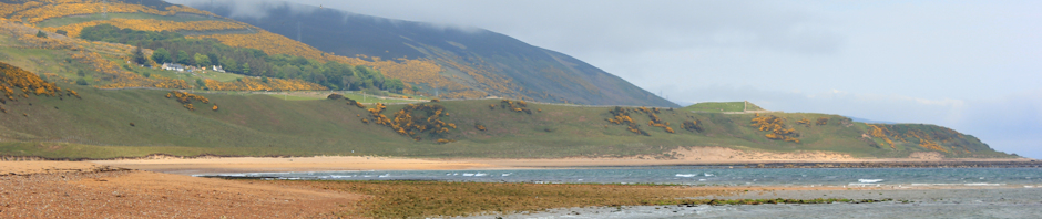
Then I reach the bank of the sea wall. Wow! I catch my breath.

Boats in the mud, Conyer Creek, Swale, Kent. Ruths coastal walk.The sea is perfectly and utterly flat. There is a pearly mist hanging over the mud and water beyond.

Sky merges into water, merges into mud.

A wide green bank stretches alongside the shore, heading past Fowley Island just off shore, eastward towards the open sea. I know there is open sea ahead. But on this beautiful morning, everything beyond a couple of hundred yards is veiled in bright blue-white light.

Sailing ships in misty light, The Swale, Kent, Ruths coastal walk.Two moored sailing ships float on still water, each one balancing above its own perfect mirror image. A soft mist rises from the water, and nearby mud, gently drifting inland, towards the bank I am standing on.

The light, the water, the mist, the stillness, the clarity of the near distance, the obscurity of the far horizon – so magical. I have never experienced anything like this before.

I take photographs, and would have lingered longer, but notice there are people on the ships. A man on one and a woman on the other, standing and talking to each other across the still water, morning cups of coffee in their hands. I feel I am intruding and hurry on.

I really enjoy this section of the walk. The bank is wide and curves gently in and out. The ground is firm. The going is easy. The water with its mystical light is on my left. Open fields, stretching to a misty horizon, are on my right.

Then I notice a strange sound. It is gun fire. Not the deep bang of a shot-gun, but a more frequent, more insistent, crack-crack noise. Looking at my map, I realise I am passing a rifle range, just inland of here.

Field of bullocks, Teynham Level, Kent, Ruths coastal walk. I pass a field of bullocks. They are nosey and come to watch me walking by them.

At some point, I sit down on a plank of wood and have a drink and snack. I feel I am making good time and, as often happens when I feel I am progressing ahead of schedule, I dawdle and enjoy the moment – taking photographs, sitting and thinking, watching the water, the light, the mud.

I am blissfully unaware of the passage of time. (As a result, I nearly miss my lunch in Faversham. But that does not concern me yet.)

Path along the bank, The Swale, Kent. Ruths coastal walk.Boat and Isle of Sheppey beyond. Ruth's coastal walk.Medway Ports sign, The Swale, Kent. Ruth's coast walk.


I continue.

As I walk along the bank, enjoying the day, I leave small, muddy, Fowley Island behind. The sky brightens. The sun, still hidden by haze, seems stronger. I pass isolated boats. Across the water is the Isle of Sheppey. Yesterday and the days before, I experienced the industrial landscape of the western end of Sheppey. Today, the view is blissfully rural. If there are industrial structures beyond, they remain obscured by the distant mist.

I pass an area of old wharves and jetties – flat concrete areas, now overgrown with weeds and encroaching greenery, the only remnants of what must have been a port or marina. It seems a long way from anywhere and I wonder what boats came here and with what cargo. Later, I notice a sign, advising me about speed limits

Oare Marshes, nature reserve, Kent, Ruth's coastal Walk.Now I reach the area of Oare Marshes, a nature reserve. A track joins the sea bank (the first road access since Conyer) and there are cars parked with people out, walking along the bank, with pushchairs and dogs. Inland there is a lake, surrounded by reeds, with ducks and swans.

The wind has picked up, coming in off the sea in gusts. I shelter in a wooden hide, looking out to sea across mud flats, watching sea birds – and eating another snack. A couple enter the hide, chatting to each other. They see me and apologise for disturbing my bird watching. I confess to only being there for rest and refreshment.

The path turns inland from here, heading down a creek – unnamed on my map, towards Faversham. At the mouth of the creek, the wind blows streamers of mist across the path. Further along, the creek has the usual assortment of fine sailing ships, pleasure motor boats and decrepid working boats.

View of creek, near Faversham, Kent. Ruth's coastal walk.

As I walk, I realise I am tired and I am getting cramping pains in my stomach. I conduct a mental check test of everything I have eaten in the past 48 hours, but can’t think of anything that may have upset my stomach.

I begin to pass houses and find myself on a small bridge. This is Faversham. It is 1:45 pm and I am hungry. Luckily, I spot a nearby pub. It looks closed. I have been misled before; finding pubs converted into private houses, despite still bearing pub signs and being marked on the OS map as PH.

There is a man leaning on the side of the bridge.

“Is there a pub near here?” I ask him.

“Yes,” he says, looking at me as if I am a little demented. “There is one over there.” He jabs his finger in the direction of the shut-looking pub. “And one further up the hill.”

The pub is, indeed, open. There is a sign up saying “no muddy boots”. I sigh, mentally. Everywhere I go in North Kent, I am surrounded by signs telling me what I can’t do and where I can’t go. Luckily, my walking boots are clean – the ground has been firm and dry. I go in.

The next sign I see says, “Last order for lunch 1:45”. On no. I look at my watch, it is 1:46. The barmaid takes pity on me. The cook is about to go home (I see no other food customers) but she will make me a sandwich. I marvel at the fact our pubs are now open long hours and can sell drinks all afternoon, but seem unable to cope with the idea that people might want to eat outside of ‘normal’ eating hours. However, I say nothing, and gratefully accept an exceptionally good ham sandwich.

I am unable to finish the sandwich. Stomach pains intervene and I run for the toilet. Then I feel guilty about not finishing the sandwich – after all, it was made especially for me. Surreptitiously, I pull out my snack box and place the remains of the sandwich in there. The barmaid will never know.

Now, I am worried about finishing the walk. As my abdominal discomfort subsides, I decide to continue. My plan is to complete a circuit of the Ham marshes, before heading for the train station in Faversham.

Over the bridge, and a sign post directs me along the other side of the creek. I walk up past boats and a marina. Every few minutes, cramping pains return and I walk, rubbing my stomach with one hand. Just as I make the decision to turn back, the pains stop. Relieved, I continue. The pains return a few minutes later and keep me company, intermittently, for the rest of the walk. Therefore, I can’t say I really enjoyed this section of the walk – tired and with a griping stomach.

Shame, because this was a very pleasant walk. The sun is shining, warmly. I follow the bank around the perimeter of this patch of flat land, surrounded on all sides by river estuaries, with Faversham in the misty distance. The air is full of bird noises. There are sea birds to my left, and land birds to my right.
View across Ham Marshes, Faversham, Kent. Ruths coastal walk.

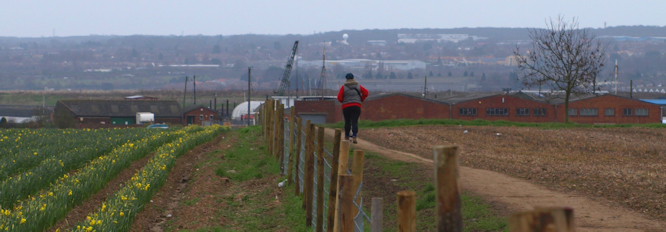
As I approach Faversham, again, I meet a man walking very briskly towards me, with his dog. At first glance, I think he is out for a walk. He keeps whistling to the dog, a black mongrel, who keeps running back, away from him, down the path towards a tent, pitched beside the bank, close to a perimeter wall. The dog clearly prefers the tent to the walker. There are three men standing by the tent. I assume the tent has been pitched by fishermen; not uncommon on the coast.

Drawing nearer, I realise there is a minor drama unfolding. Two of the men, by the tent, are uniformed police officers. They stand, tall and large, with their fingers hooked into their belts and jackets. One of them draws out a notebook. The third man is short and skinny, stooped shoulders and with a guilty look to him. The dog returns to lick the skinny man’s hand, and then disappears in the direction of the walking man, who is disappearing quickly into the distance.

I notice the tent is not full of fishing equipment, as I initially assumed, but contains a rolled up sleeping bag and some personal effects.

Putting two and two together, I decide the young man is sleeping rough (albeit with a tent). Somebody has reported this to the police and he is being ‘moved on’. The other man (now a dwindling dot in the distance) was probably his companion, but has decided to scamper off.

I feel sorry for the skinny man.

Somehow it seems wrong to take photos of this sad scene. So I resist and walk on.

Detour notice and map, Saxon Shore Way, FavershamNow I find the path barred, with the usual assortment of notices telling me I can’t pass here. New buildings have been put up along the bank of the creek and, although it would appear the path was diverted to a walkway alongside the water, the foreshore has been eroded by tides and the path has disappeared.

I feel angry. How can a new footpath have been so easily lost? What were the planners thinking in allowing an important section of The Saxon Shore Way to be destroyed? And why can’t I walk through this new housing area?

Now I have no choice. A map shows the detour I have to make. It is not far. But the detoured route follows the perimeter fence of an industrial area and the walk, once so scenic, is now the usual grim stroll alongside high fences warning me not to trespass and, in case I was tempted, reminding me that I am being watched by CCTV.

Perhaps it is the tummy pains, still coming and going, or perhaps it was the sad scene with the homeless young man I just witnessed – but I feel unusually aggrieved by the detour.

Come on Swale District Council. Come on Kent County Council. If you want to create a nice long-distance walk, then, for heaven’s sake, get it right!

New Dr Who Tardis? Faversham. Ruths coastal walk.The only good thing about the detour was the strange Tardis box I came across, guarding the access to the ‘private’ housing area and the industrial estate. If I was Doctor Who, I would abandon the little blue box for this one.

I reach a road. Looking back along the river, I see the housing area which forced my detour. Although it looks lovely in the setting sun, internally, I half wish the blasted new houses will slip into the river, following the footpath into the watery depths.

But that is unkind.
New development, Faversham, Ruth's coastal walk.

Faversham, Kent. Ruth's coastal walk.Ahead of me, Faversham looks lovely.

But my feet are tired, my stomach hurts; I don’t want to wander any further than I need to. I seek directions, constantly, from every passerby I come across.

“Where is the railway station?”

I walk through a pleasant town centre – coffee bars, interesting shops with art, books and antiques, people out strolling – yes, this is a very pleasant town. The first truly nice town since I left the centre of Rochester.

At the station, queuing for my ticket. Two small, anxious boys approach me. I guess they are around ten years old.

“Can you lend us enough for our train tickets? We haven’t enough money. We need, like … two pounds?”

They have middle class accents and are dressed in clean clothes. Is it wrong to find myself more sympathetic to their plight because they are middle class boys? I don’t ponder too long. I give them two pounds. They buy their tickets and run back to me to give me the change. I ask them if they have enough money to get home. They nod.

Safely seated in the train, I clutch my grumbling stomach and think about the events of the day. After a beautiful start, I got caught up with annoyances and dramas – my tummy ache, the pub with no food, yet another forced deviation to the path, the homeless young man with the policemen and the anxious young boys without enough money for their fare home.

People ask me if I get lonely or bored on my walks.

No. Not often.


Health update: That evening, on my return home, I felt very ill indeed; nausea, diarrhoea and crampy pains, along with the shivers and a headache. I had a much-needed bath and went straight to bed. It was some sort of bug, from which I took 48 hours to recover.

Miles walked = 12


Posted in 05 Kent | Tagged , , , , | 3 Comments

Stage 37. Sittingbourne to Teynham

map, Sittingbourne, Swale District, Kent. The Saxon Shore Way between Sittingbourne and Faversham runs along the water, first along the edge of Milton Creek and then along the bank of The Swale, before following the estuary into the heart of Faversham.

According to my map, the distance would be about 12 miles. More – if I get lost. According to the B&B landlady in Upchurch, this is one of the most punishing parts of the route.

My husband is away, skiing. I have lost my valuable support and there is nobody to rescue me if I want to give up before I reach Faversham railway station. So, being a coward, a wimp and with my determinedly I-am-going-to-enjoy-this attitude to walking, I have decided not to attempt this section in a single day.

Teynham Railway Station, Ruths coastal walk, KentI am, therefore, breaking my walk at Teynham station. Although this requires a trek inland of about 1.5 miles, I reckon this is the best plan.

My day begins well. I drive to Teynham station and take advantage of the free car parking. My plan is to travel back to Sittingbourne to resume my walk. Unfortunately, the Teynham ticket office closes at 9:30 am and I have just missed the chance to buy a ticket. There are stern signs on the platform, instructing me not to travel without a ticket, or I will be flung in jail. There is a machine on the platform, but it is broken.

Then I spot a machine I can use to ask for help. I duly push a button, half expecting this machine to be broken too. To my surprise, I end up speaking to an Indian with a decidedly indian accent. I explain my situation. He asks me to spell Teynham. Mentally I do some tut-tutting. I assume he is manning the help line from some distant Indian city. I think of Mumbai, or Delhi, or Calcutta. He is very polite and tells me it is quite alright to travel without a ticket, given the circumstances.

Later I learn that Teynham is pronounced Tenam. No wonder he needed to check the spelling.

As I wait, two young people begin wandering down the platform. They are having an argument. The girl is in front. She is a pretty teenage, but has a sharp face and a smirking grin. I recognise this grin. It is the expression my 5-year-old daughter used to have when deliberately winding up her sister. Behind her, shouting expletives, is a skinny young man pushing a push chair. Well, not exactly pushing it; he shoves it angrily forwards and it runs down the slope of the platform towards the perimeter fence. He grabs the handles, jerking it back, before pushing it forwards again. He is shouting at the girl. She runs ahead of him, tossing her hair.

Then I realise there is a child in the push-chair.

The girl must be the mother. The angry young man is the father. The child is fat, dribbling and lost in a world of his own.

The man catches up with the girl at the end of the platform. They sit on some steps, still arguing. He holds the push-chair with an outstretched arm, a few fingers wrapped around one handle, as though the child is nothing to do with him. The girl is refusing to take the push chair.

A middle-aged woman appears on the platform. The couple, still arguing, get up. They do a little dance around this woman. The girl puts the woman between herself and the young man with the push chair. He circles the woman, trying to get close to the girl. She moves further around, keeping the woman between them as a buffer – a human shield.

The woman realises something odd is going on, the girl being too close for comfort – invading her personal space as she plays cat-and-mouse with the young man. She walks away and stands with her back to a post.

A few more people arrive on the platform. When the train pulls in, I choose not to sit in the same carriage as the young couple. I feel alarmed. They are acting like 5 year olds. But they are out with their baby. Is it safe to leave such a young child with two adults who are clearly little more than children themselves?

The journey to Sittingbourne is very short. I become unduly agitated. The buffet trolley is in my carriage and the attendant stops next to my seat to serve the couple in the seat opposite. They slowly deliberate over choices of food and drink. I feel hemmed in and worry about getting off at the next stop. As the train slows, I get up and push past the trolley, spending the last few minutes of the journey standing by the doors.

I get off the train at Sittingbourne, as planned. I pay for my ticket at the booth in the station. I notice I am the only one who does this.

When I walk through the station car park, I spot the young man, still pushing the push chair in the jerky manner I noticed before; – angrily shoving the chair away from his body and letting go of the handle, walking a few paces and catching up with it, grabbing the handles and then pulling it back, before shoving it forward and letting go again. The baby remains quietly unperturbed by this bizarre ride.

The young man is shouting a string of expletives. His shoulder are hunched up with rage. He is walking past the taxi rank, looking around. I can’t see the young woman. She has run off or is hiding.

I must say, I find this incident very unsettling. It is not clear how anybody could, or should, intervene. I worry about the child. Despite my concern about the safety of the baby, I walk on.

The first part of my walk is along busy roads with lorries hurtling by. Sittingbourne appears to be a town of industrial estates linked by roads. Perhaps this is unfair. It is just the impression I get. I am really looking forward to re-joining a proper footpath and sigh with relief when I see the alley leading off to the left. This should take me to the shore.

Closure of footpath notice, Sittingourne, Ruth's coast walk. But, wait. No! The footpath is closed. My heart sinks.

Luckily there is a detailed sign and a map. It appears they are building a bridge across the river at this point; responsible for the closure of the footpath on the other side (and the detour I was forced to make yesterday) as well as on this side.

I pull out a notepad and write down the detour instructions. I check my OS map. Yes, the instructions and my map both concur. There is an alternative route. And it is a public right of way.

Derelict chapel, Sittingbourne, Kent, Ruths coast walk.Upside down CCTV sign, Sittingbourne, Kent. Ruths Coast Walk.I pass a derelict church, or chapel.

Now I walk along beside an industrial estate (where I notice an upside down sign – one of the perils of attaching a sign while standing on the wrong side of a fence!).

Next, I cross over a busy dual carriageway and walk down a track towards a scruffy caravan site. The instructions tell me to follow the track as it skirts the caravan site and leads onwards.

But the track appears to lead into the centre of the site. And stops.

This is not one of those holiday caravan sites of the type I have met before on my coastal walks. This is a domestic trailer-park site for people who cannot afford anywhere else to live. There is rubbish, abandoned cars, chickens and dirty men with greasy hair.

“You can’t get through there, mate.”

“I’m looking for the path.”

“Where you heading?”

“To the coast. To the sea wall,” I say, not sure that I want to tell this disreputable looking man where I am heading.

Rubbish across Saxon Way and cycle track, Sittingbourne. Ruth's coastal walk. He tells me the track is hidden under a mound of rubbish, “temporarily” deposited there.

But if I scramble up a bank and down the other side, I can rejoin the track.

“It’s a long way to the sea wall, mate,” he warns me.

I scramble up the rubbish strewn bank. This is not only supposed to be an official footpath, but is also one of our national long distance cycling routes (National Route 1, indeed). Nobody could cycle here. There is so much broken glass on the bank, you would have to carry your bike or risk punctures.

Track past Little Murston, Sittinbourne, Kent. Ruths coastal walk. After that, the going is easy. I follow a track winding through woodland with lakes on my left.

I meet a man on a cycle – not a touring bike, but more likely to be resident of the caravan site.

I see nobody else for miles. Then I join a narrow road and am passed, bizarrely, by a dustbin lorry. It returns a few minutes later, having collected bins from the only house I come across on this section of the walk. Beyond the house (with the usual “private”, “keep out”, “you are being watched” signs) the track leads through fields towards the sea wall.

Paper Mill, Sittingbourne, Kent. Ruth's coastal walk.Jetty and Ridham Dock, Sittingbourne, Kent. Ruth's coast walk.Sheppey Crossing Bridge, Kent, Saxon Way, Ruth's coast walk.Across the fields, and across the water beyond, I can see where I walked yesterday; the tall chimneys of the paper mill, the jetty of the gravel works and the sweep of the bridge beyond, leading to the Isle of Sheppey. The air is clear and the sun is shining.

Mud, wrecked hulls and water, The Swale, The Saxon Shore Way, Ruth's coastal walk.When I reach the sea wall, pleased to be back on The Saxon Shore Way, before me stretches a lovely vista; gleaming mud flats, the obligatory wrecked hull, an expanse of blue water beyond.

Although I am still in the shelter of the Isle of Sheppey, I am nearing the open sea again. I feel a surge of blissful happiness. Progress at last and the sea is ahead of me.

Ruth, on coastal bank, Saxon Shore Way, The Swale, Kent.I sit down, on the landward side of the bank to avoid the wind, facing open farmland, inland water and a sunlit landscape, to have a leisurely picnic lunch and enjoy the sun on my face.

With some difficulty, I remember how to use the timer on my camera and take a self-portrait.

Walk towards Conyer Creek, From Sittingbourne, Saxon Way. Kent.
Then I continue walking. The path is wide and easy, curving gently.

The tide is coming in and the mud flats between my bank and the Isle of Sheppey are soon covered.

Conyer Creek, looking out towards The Swale. Ruth's coastal walk.
After a while, I reach Conyer Creek and turn inland. The mouth of the Creek is lovely – mud flats and blue water, with bright buoys marking the deeper channels for shipping to follow.

I am following the path along the side of the creek, as it winds through fields of sheep and baby lambs.

Conyer Creek, smart houses. Ruth's coastal walk. Kent. On the other side are some fine-looking residential houses and a host of small ships, moored in the mud and water.

People are out walking dogs, the first people I meet since the man on his bike. A small group, clustered around a car, are flying model planes. The planes whine and whirr – and dive bomb the sheep. Women with dogs tut-tut at this noisy intrusion into the rural scene.

Conyer Marina, Saxon Shore Way, Kent. Ruth's coast walk.At the end of the creek is a marina and I walk round the fencing, skirting the boat yard.

When I reach the road, there is a bus waiting. It is showing “Teynham” as its destination. I am tempted to get onboard. But take the public footpath instead.

I walk down a narrow gravel road, that runs straight as far as the eye can see. This is an official bridleway and takes me directly to Teynham station. There are orchards of fruit trees to my left, paddocks of horses to my right. The way is lined with trees and it is very pleasant walking. There is no danger of getting lost. I have nearly reached my destination.

At the end of the bridleway, I walk through an orchard. There is a roaring sound and a small motorbike, ridden by a young man, races past me. The bike is one of those off-road types, so small that it forces the man to sit hunched up with his knees close to his ears. It bounces over the uneven ground. He roars away, following the perimeter of the orchard.

A few minutes later, and I come across his companions; another young man, waiting impatiently for his turn and a girl. The girl is very pretty. She is sitting on a large stone, her knees drawn to one side and her legs together, like a mermaid on a rock. She is wearing a short skirt and has long hair. With one hand she is grooming her hair, running fingers through it and flicking her head backwards, so that her hair cascades in a long straight waterfall down her back. She looks beautiful.

I notice there is a collection of lager cans at the base of the stone. Neither of the young men is wearing a helmet.

As I pass them, I think of the freedom of youth. There is a brief time when the world is young, you have no cares, and you can sit, preening on a stone, while young men show off their skills on mini motor bikes, oblivious to the danger of broken bones and brain damage, in a sunny orchard, in early spring, enjoying a cold lager.

Then I think of the young couple with their public quarrelling and the unwanted baby caught up in the middle of their childish squabbles. Yes, there is the wonderful freedom of youth – but it is a fragile thing and easily lost.

The footpath crosses the train tracks and emerges at the end of Teynham station. There are a group of young lads loitering in the car park. I feel a pang of anxiety. But I find my car, unscathed.


Miles walked = 7 miles.
Foot paths blocked = 1
Number of times got lost = 0


Posted in 05 Kent | Tagged , , , | 6 Comments

Stage 36. Upchurch to Sittingbourne

I wake this morning feeling flushed and I wonder if I am running a fever. When I look in the mirror, I discover I am sunburnt from yesterday’s walk.

Orchard, Upchurch, Ruth's coastal walk
After breakfast, my host in the B&B shows me the best footpath to take from Upchurch, heading north to pick up The Saxon Way. I set off early (before nine o’clock), knowing I have a long way to walk today. The weather forecast is fine. I am taking no chances and have applied sunblock.

The footpath winds through an orchard, where the well-pruned trees are just beginning to blossom. The birds are singing. The sun is shining. The world is good.

Mobbed by sheep, Upchurch, Ruth's coastal walk, Kent.At the end of the orchard, I walk along a track, running alongside a field of sheep and young lambs. The sheep catch sight of me and begin charging towards me, lambs following. They are after food. There is a hullabaloo – deep-throated baas from the sheep and high-pitched echos from the baby lambs. As I walk along the field, the flock keeps pace with me and the noise doesn’t cease until I turn away, towards the shore wall .

Marina, Kent. Ruth's coastal walk. The coastal path here is lovely. The morning sun gleams off sea and mud. There are house boats, many clearly being occupied, pleasure boats moored on the bank and further off the shore, in mud and water, an assortment of sunken hulks. Across the water is the familiar view of Kingsnorth Power Station.

Private. Kent.
Unfortunately, I come across a marina and boatyard with “Private, No Access” signs. I am forced to make an inland detour.

Walking across fields, along a way that is seldom used, usually leads me to disaster. And this, today, is what happened – I got lost, twice.  

The first farm I cross has well maintained ‘kissing’ gates, allowing me access to the fields. Although the footpaths are untrodden and invisible, I can identify the exit route from each field by spotting the gate on the far side. Nothing impedes my progress, the ground is dry and firm with bare earth and no crops or mud to force a detour. So far, so good.

Then I enter a field, through one of these ‘kissing’ gates, and find the path is bounded by fencing. Now, this is the official Saxon Way, remember; one of our long distance footpaths. But instead of leading directly across the field – as per the official route, marked on the map – the path takes me round the sides of the field. Since the field is indented by a copse, and the path leads around the edge of the protruding copse, I end up walking much further than 2 sides of a triangle.

Worse still, close to the trees, the path is narrow and undermined by rabbit warrens. I am unable to detour onto firmer ground, hemmed in by wire fences, but forced to stumble across this overgrown and uneven terrain. Luckily, as this is March, there are only a few, low nettles growing here. But I can see the route will soon be overgrown with them. Meanwhile, to my right, is a bare empty field with no reason at all for this forced detour – no crops, no animals, nothing.

Spot the footpath, Kent, Saxon Way, Ruth's coastal walk.Having nearly completed this tortuous circuit, I reach a section of the path that is, well, completely impassable. The fence excluding me from the farmer’s field is intact. But the fence on the other side has fallen across the path, where an assortment of brambles, thistles, old gate posts and rubble are strewn across the way. It is hard to believe this is supposed to be a footpath.

So, I jump over the fence and into the field. This is, I think, what I should have done at the beginning. Walking across the field, following The Saxon Way route as marked on the OS map, I reach a broken gate and leave the field easily.

Pleasant stop beside a pool, Saxon Way, Ruth's coastal walk A few minutes later, and I am lost again. I was congratulating myself on good progress and had stopped near some ponds for a drink and snack. I see some Saxon Way signs – so I know I am on the path. It is just not clear where to go. I set off across another field. In retrospect, this is where I went wrong and ended up heading too far South. I end up on a track, and then on a road. A passing motorist stops and asks where I am heading.

“I’m trying to find The Saxon Way,” I tell him.

“It’s over there,” he says, pointing back in the direction I have come. “And if you find any Saxons, let me know.”

I thank him, but, disoriented, I don’t believe him. Later, after losing all the expected landmarks and resorting to the compass on my iPhone, I realise he is right. I have come too far to turn back now, but I see a way to rejoin the footpath.

Cursing the lost time and extra miles incurred by this unnecessary detour, I head towards the village of Iwade. Catching glimpses of the main road and the bridge to the Isle of Sheppey, I realise I am very close to Kemsley, on the outskirts of Sittingbourne. This is one of the destinations along my planned route today and I am almost tempted to cut across country and make straight for Kemsley. But this would pass out a long loop of The Saxon Way as it winds close to the shore. I resist.

Bedlams Bottom, Saxon Way, Kent. Ruths coastal walk.Now I find a footpath, leading across a large field of grazing horses, towards a spot marked endearingly on the map as “Raspberry Hill”. It is not much of a hill, and I see no raspberries, but find myself back on The Saxon Way and heading down towards the shore.

The sun is behind me and as the open space of mud and bright water opens up before me, I feel a surge of energy. There is the familiar whiff of rotting vegetation from the muddy marshland, the ubiquitous wrecked hulls that litter this part of the coast and the familiar tower of Kingsnorth Power Station in the hazy distance, across the water. Yes, I am back on familiar territory. Back on the marshy coastline once again.

On my map, this area of mud and water is named “Bedlams Bottom”. I must confess, this mile of path is the best part of my walk today. Luckily, I have no idea of the difficulties to come.

Saxon Way, fallen sign. Ruth's coastal walk, Kent.I am walking on a peninsula of farmland and watery wasteland – an area called Chetney Marshes.

The Saxon Way leads me towards some ramshackle farm buildings, not marked on my map. The footpath sign is lying on the ground. I hesitate. Do I go through this farm-yard, or round it? I hear a strange noise. Is that a hoarse cockerel crowing? Further on, I see it is not a cockerel. It’s a peacock.

Keep out signs, Chetney Marshes, Kent. Ruth's coastal walk.Once again, I have lost the track. Warning signs (“Private”, “Keep off”, “Nature reserve”) bar my way forward along the marshes. It is not clear to me who owns this land. There is no explanation on the signs.

Rude Signs, Chetney Marshes, Ruth's coastal walk in Kent.I would expect a proper nature reserve to have signs indicating ownership and some information about the significance of the reserve.

Yet again, I am suspicious of this “reserve”. Who owns it? Why is it private? Why are white vans and other cars driving across the tracks that criss cross this peninsula, while walkers like me are kept out with rude signs?

I find the Saxon Way again. It runs along a hard, rutted path. Walking is difficult and the countryside is flat and featureless.

Saxon Way, towards the bridge. Ruth's coastal Walk. KentI cross the peninsula and, on the far side, I walk along the water (The Swale), along a lovely raised grassy bank, with rabbits hopping away from me.

It is lunch time. Stopping to have a drink and a snack, I take in the view of across the narrow strip of water towards the Isle of Sheppey. A few boats make their way along the … is it sea or river? There seems to be a fair amount of industry on the Isle and ahead of me, looking along the bank, I can see the arch of the road bridge and distant traffic crossing too and fro.

Now I see plenty of birds – Canadian geese, ducks, moorhens, ghostly heron, oyster catchers, a hovering BIG bird – I wonder what it is – too big for a harrier.

Bridges to Isle of Sheppey, Kent, Ruth's coastal walk.Continuing along the bank, heading south-east, towards the huge bridge to Island. As I draw nearer, I realise there are two bridges. One (the high one – Sheppey Crossing) seems to be carrying hunch back lorries. Then I realise they are car transporters – a constant stream of them, travelling from the Island to the mainland.

The other bridge (Kingsferry Bridge), lower down, is carrying slow-moving traffic from the mainland to the Island.

Bridges to Isle of Sheppey, Kent. Ruths coastal walk.I cross under the bridge. On the other side is blue water and lots of little motor boats.

Running late now, I pick up my speed, walking at a quicker pace than I would naturally choose. So intent am I on making good progress, I fail to stop and check my map. To my surprise, and dismay, I end up at a dead-end. The bank ahead of me is taken over by a huge quarry with a jetty, fenced off by security fencing. A large boat is moored and a huge machine is scooping gravel from the quarry site and emptying it into the boat. I can’t believe the path is blocked. What am I going to do?

Then I check the map and realise the official Saxon Way leaves the bank, shortly before reaching the quarry and heads inland, skirting this industrial area, before rejoining the bank further south. There are, of course, no signs to indicate the deviation.

Nice path around industrial area, Saxon way, Ruth's coastal walk. Kent.Cursing, I retrace my steps and, after a short scramble through rubbish and debris, I arrive at a section where a lovely path has been created on the raised bank the follows the peripheral road around the industrial site. There are bushes on either side. The path is reasonably well trodden with short grass and soft ground. I cross over a disused railway line.

Back on the bank, I walk through a VERY industrial landscape. But there is blue water and boats to my left and, ahead, the view of open sea in distance – a promise of things to come – hurrah! 

Next bit of the walk is completed in a blur of fatigue. I walk faster than I wish to. Apart from one dog walker near the industrial site detour, I meet nobody.

Tired and irritable, I find a sign nailed to a post. The sign is encased in plastic but is faded by the weather. As far as I can see, the sign is warning me of a footpath closure, due to bridge building.

Yes, The Saxon Way is closed between Gas Lane and a map reference. I find the map reference – just South of here. Where is Gas Lane? The OS map does not have street names, just place names and, of course, map references can be found on it. Damn. Why give a map reference and a street name?

Paper Mill, Kemsley, Saxon Way, KentSouth of where I am standing, the Saxon Way follows the line of Milton Creek, running towards Sittingbourne. The map indicates the path passes close to a railway station and a built-up area of Kemsley. Before that, it winds around the perimeter of another huge industrial structure (I assume this is a power station, but later learn it is a paper mill). I hope the path is open until I reach the end of this industrial site. Then I plan to cut off the path, heading towards Kemsley. There must be a road connecting the station to Kemsley.

I resign myself to walking along roads from Kemsley to Sittingbourne.

Jetties in The Swale, Saxon Way, Kent. Ruths coastal walk.If it wasn’t for the fear of finding my route blocked, forcing a long walk back the way I have come, I would enjoy this section. I pass lots of industrial sites – a sewage works, a rubbish tip with pipes rising out of the rubbish (reclaiming gas?), jetties and structures whose purpose I can’t fathom.

Now I am walking along the perimeter of the large paper mill and, as I reach the end of the high perimeter fence surrounding the mill, I notice there is no obvious route inland. My heart sinks. What should I do? Continue on and be forced to turn back later? I have to reach Sittingbourne. My car is parked there and I have a bed booked for the night at a B&B in the town.

Then I notice an unmarked pathway, leading inland from the Saxon Way, hugging the perimeter fence. Is it a proper path? I have no idea. But it is well trodden.

I follow the path for a short distance. It runs with the high fence on my right and tall bushes on my left. I can’t see far ahead. Scrambling up a bank I find, to my horror, I am on a railway line!

Where is the railway station? I can’t see any sign of it. To my right, the line ends in some buffers. To my left, it stretches out in a slow curve, heading towards Sittingbourne. Straight ahead are bushes, a steep bank and high fences. There is no way to cross. If there are roads and houses on the far side of this, I can’t see them.

Looking at the map, I realise I am a long way from a road. There is the bulk of the paper mill ahead of me, fenced off and inaccessible. The only real access point here is the footpath I have just left.

Just then, I see a boy walking away from me, along the line, in the direction of Sittingbourne. He is wheeling one bike and carrying another one. Maybe he knows what he is doing. I follow him.

As I walk along the edge of the line, I notice the line appears to be used. It is clear of weeds. There are no missing sections. I can tell from the map it is a “Light Railway”. That means steam trains and tourist rides, doesn’t it? Nothing will be travelling along here on a weekday in March, will it? I notice there are no signs saying ‘do not trespass’. And there is room at the sides of the track for me to stand aside if a train comes.

It still feels odd, and very wrong, to be walking along a railway track.

I speed up to keep up with the young lad ahead. If he turns off, I want to see where he goes. I have to follow him. I can’t follow this track all the way to Sittingbourne. In any case, I suspect the track will be fenced off by security fences when we reach a more populated area.

Passing a building site, workmen in yellow jackets nod and say hello. If they think it is odd to see a middle-aged woman walking on a train track in the middle of nowhere, they are too polite to say so.

The boy turns off the track, just where gravel roadway crosses line. I follow him, relieved to be away from the railway, and find I am on an industrial road. I get the feeling this is part of a construction project. The road is made of loose gravel and there are speed restriction signs.

Church Marshes Country Park, Kent. Ruth's coastal walk.Then, I see a church ahead. At last, a landmark. The map says I am in a ‘country park’ – very new park with baby trees, tiny trunks surrounded by anti rabbit protection fences. There are a few people walking here, some with dogs, so it must be public land. I head south-westerly, across the park, to join the road that leads to Sittingbourne.

To my horror, I find the way ahead barred. There are temporary structures, offices, building materials and, worst of all, a big gate with security men, separating me from the road. This is a giant building site after all.

It is five minutes to five o’clock. The workmen, in high vis jackets and hard hats, are congregating around the gates, loading vans, preparing to go home.

“Can I pass through here,” I ask, hoping I look suitably tired, lost and pathetic.

“You’re not supposed to love,” they say. “Where have you come from?”

“Somewhere over there,” I wave vaguely in the direction of the railway line. “I didn’t realise I couldn’t get through.”

It is five o’clock. They are going home. They are in a good mood. They let me through.

Now I walk along busy roads towards the centre of Sittingbourne and the comfort of another B&B. Thank goodness I arrived before they closed and locked the site. I could have been stuck there – trapped.

There is one more odd experience on this strange day.

To my left, I pass a ramshackle mobile home. It looks like some temporary structure, belonging to the building site. Then I notice the NHS sign.

This is an NHS surgery? It can’t be. It is!

Darzi Polyclinic - Sittinbourne, Ruth's coastal walk

Yes, this horrible shack is one of the much vaunted Darzi Centres, officially entitled “GP-led Health Clinics”, where instant access to a GP and a range of other services in a one-stop shop will be provided for the convenience of patients and because us humble GPs are, apparently, incapable of providing a decent service. The last government promised the public would have one of these wonderful clinics (a “Super Surgery” or “Polyclinic”) in every area.

This is one of those clinics? Dreadful. Truly dreadful – like a third world health facility.

I assume it is disused. Then a small car pulls up beside it and a large man makes his way, leaning heavily on a stick, toward the door. It is being used. What a disgrace. Surely the people of Sittingbourne deserve better than this?

I am almost too tired to be angry. Almost.


Miles travelled = 15 miles (felt much longer).
Railway tracks walked along = 1.
Getting lost = three times.

High points: orchards and Bedlams Bottom.
Low points: seeing the Darzi Polyclinic.

Scenic value? 3/10 due to the dominating, everpresent, industrial scenery.


Posted in 05 Kent | Tagged , , , , | 3 Comments

Stage 35. Gillingham to Upchurch

Cat with weird eyes, Gillingham, Ruth's coastal walk.Gillingham station is horrible. I walk behind an oversized girl, with a homemade tattoo on her bulging spare tyre, trying to get past the ticket barriers with a child’s ticket. She is stopped and, as I leave, she is being cross-examined by three ticket inspectors.

The only thing of interest I see during my walk down towards the shore, is an amazing white cat with different coloured eyes.

Woman with laden pushchair, Gillingham, Ruth's coastal walk
I walk behind a middle-aged woman pushing her grandchild (I assume) in a push chair. She has so many bags hanging off push chair, if she let go of the handles it would surely topple to one side. To be fair, most of the bags are full of disposable nappies.

Today I am carrying enough in my rucksack for an overnight stay at a B&B. This took a great deal of planning, as I try to travel as lightly as possible, so I have a change of clothing and some wash things, that’s all. At one point, I realise I am being eyed up by a fellow walker, walking on the other side of the street. Stealing glances towards him, I realise he is a real tramp – disheveled and with a dirty rucksack on his back.

St Mary Magdalene Church in Gillingham Green, Ruths coastal walk.Partly to avoid walking too closely to him (and I am slightly ashamed of this), I linger in a church yard and get my camera out. A man, putting out the bins, motions me over and lets me into his garden, where there is a better view of the church. The churchyard is nice and just below it there is a green park (Gillingham Green) where, finally, I find some signposts for The Saxon Way.

I duly follow the signs, leading me down a nice lane until I reach a busy dual carriageway. Then the signs stop. Which way do I turn down the road? Left or right? The Saxon Way runs parallel to this road, on the far side, but how do I get access to it?

Then I remember my last visit here and see a familiar landmark.

Yes, I turn left and head for gasworks, a landmark I recognise. (Later I realise I could have joined Saxon way by going right – this would have been shorter but I would have missed excitement of The Strand).

Kingsnorth Power Station, in morning mist, Ruth's coastal walkThere are people in The Strand and, unlike my last visit, the toilets are open. Still no snack bar or tea shop – shame. There is a low mist hanging on over the near horizon and I take some spooky snaps of Kingsnorth power station and the industrial structures on the Isle of Grain behind.

Little Gull, Ruth's coastal walkThere are some very noisy gulls with black heads. I am getting better at recognising wild life. I believe these are called Little Gulls.

Now the sun comes out and, as I walk eastward along the shore, the area suddenly appears more attractive. Some time and effort has been spent here, turning the waterside into a scenic area (despite the surrounding industrial landscape). After walking past some houses and industrial areas, I come across a couple of lovely nature reserves – including the Riverside Country Park.

Riverside Country Park, Gillingham, Kent. Ruth's coastal walk.

There are sunken barges in water. Kingsnorth Power Station remains a presence in the background. And, strangely, I notice ducks – dabbling – in the sea!

I see a notice about interesting flora and fauna. One thing that strikes me is the phrase “… grass snake, this is one of two species of snakes found here” – what is the OTHER one? There are only three species of snake in Britain, so it must either be the smooth snake or adder? (Later, I look up ‘smooth snake’ on the internet and discover these are rare and not resident in Kent. It must be adders.)

Sign with interesting names, Gillingham, Kent. Ruth's coastal walk.There are wonderful place names here. Horrid Hill is a small peninsula – with not much of a hill. Motney hill is a larger peninsula with a definite hill. The path leads here and joins a road. Not many people seem to walk this way. I wonder why.

The first clue is a tanker, passing me along the road, with “non dangerous waste” on its side. The second clue is the smell.

Yes, Motney Hill is a pretty peninsula but houses a sewage works.

Sewerage works, Motney Hill, Kent. Ruths coastal walk.

So, the far end of the peninsula is inaccessible and the shore is screened off by large fences. I wonder how people can work and live with such a stink – there are residential houses here with children’s play equipment in the gardens. But, after a while, I don’t notice the smell anymore. I guess you can get used to anything.

Otterham creek with sunken boats, Ruth's coastal walkI follow The Saxon Way as it winds along the edge of Otterham Creek. Moored in the creek are a motley collection of old houseboats, sunken ships and decaying wharves.

After that, Saxon Way turns inland and I walk along quiet roads and footpaths, up Windmill Hill, through orchards. I catch a glimpse of a man skinning and gutting rabbit with no sign of a knife – in a field beside his open 4×4. From the glimpse I have, he appears to be deftly removing fur and innards with his bare hands. He must have a knife! I don’t linger to find out.

After that, I am forced to follow a road. Although there is not much traffic, the road is dangerous for walkers, barely wide enough to allow two cars to pass and certainly not wide enough for two cars and a pedestrian, there are no pavements or verges. The map shows the footpath branching off to the left. I see a likely looking track, but it has ‘private’ signs and a barrier (albeit raised to allow access). Continuing on, I realise that this must have been the footpath – the official Saxon Way. By this time it is too late and I have climbed a steep hill and am in the village of Upchurch.

I resolve to report this to the council. Up until this point, this section of The Saxon Way was well signposted. Someone has removed the signs.

I stop at a busy little village co-op and buy some coke and snacks for tomorrows walk.

Hawthorn blossom, March 22nd 2011, Ruth's coastal walk.Then, walking onwards, I arrive at my booked B&B., where I am given a warm welcome, a cup of tea and a huge slice of cake in the garden. A robin joined me for tea, perching on the back of the garden chair.

In the fading sunshine of this warm day, I notice the garden birds very noisy. It must be spring.

Already I am worrying about my walk tomorrow. I feel exhausted, have had trouble finding the correct footpaths, and yet I have only walked 7 miles today. Tomorrow’s walk will be 14 miles to Sittingbourne.

I was right to be worried. Little do I realise what a mission this will be!


Posted in 05 Kent | Tagged , , , | 9 Comments

Stage 34. Hoo St Warburgh to Rochester

Church at Hoo St. Werburgh, Kent - Ruth's coastal walk.I walk through the graveyard of the church at Hoo St Warburgh. There are fresh graves with real flowers and little windmills. On a child’s grave there is a teddy and balloons. I refrain from taking photographs – it seems too intrusive on other peoples’ grief.

It may be a grey day, but I am glad to be alive.

I cross the road and join the Saxon Way. In front of me, Kingsnorth Power Station is belching steam, but I am not heading back towards it. Instead, I follow the path as it turns to the South and I walk briskly down the hill to the shore.

I am going to find a river, not the sea. Oh, I long for the sea but I have the River Medway to navigate first. I have only seen this river from the M2, whizzing over it on the way down to Dover or Folkestone, on family holidays.

Saxon Shore Way, near Hoo, Kent - Ruth's coastal walk.

According to the OS map, There are 2 Saxon Ways – one running close to the river, the other further inland, running along the top of a slight ridge. My husband advised me to take the top path as the views would be better. I am inclined to take the route closer to the shore – following my self-imposed rule of sticking as close to the water as possible.

Spot the foot path? Saxon Way, Kent. Ruth's coastal walkWhen I reach the river bank, turning right to follow the shore, I wonder if I have made a big mistake.

The path winds through unfriendly semi-industrial spaces and is, at times, hard to spot. Oh, here it is, hidden behind this fence and with unappealing barriers making sure I keep to the straight and narrow. Narrow it might be. Straight? I wish!

When I emerge from this unpleasant alley way, I find I am walking round the edge of a marina. Fences line my path and there are many signs telling me not to trespass, private property, keep off. There is a strange jumble of boats; some large ships that appear abandoned, a collection of houseboats, a few yachts and an assortment of small tugs and motorboats.

The marina has a slightly run-down feel to it, but at least it is used.

Marina and Private sign, Saxon Way, Ruth's coastal walk.Houseboats, Saxon Way near Hoo. Ruth's coastal walk.Hosing down in the Marina, Saxon Walk near Hoo. Ruth's coastal walk.

Emerging at the other end of the marina, the walk stretches ahead of me, hugging the shore line. This is the most pleasant part of the walk so far and, indeed, the most pleasant part of the walk for the rest of the day.

Saxon Shore Way, from marina at Hoo towards Rochester, Ruths coastal walk. The shore is typical estuary – a mix of mud and shingle. There are obvious signs of erosion along the bank. In some places I can see, above my head, large, exposed tree roots. Here parts of the bank (trees and all) look as if they could come crashing down at any moment.

Now I realise why there are two Saxon Way’s marked on the map. At high tide, this path would be covered.

collapsing pill-box, Ruths coastal walkThere is the obligatory, and collapsing, pill box.

Across the water are some nice looking, modern houses.

Looking at my map, I realise this must be a new residential development on St Mary’s Island, part of the town of Rochester. The brightly painted houses look somewhat surreal against the muddy estuary and the hulks of wrecked and abandoned boats.St Mary's Island, Rochester, Ruth's coastal walk.

As I approach Lower Upnor, I see ahead of me a castle on the river bank. It rises, imposingly above the water. The light is too poor for photography. Later I learn this is Upnor Castle built in the 16th Century to protect the Medway, on the orders of Queen Elizabeth the 1st.

My path now winds around the edge of an industrial area, some parts of which appear to belong to the Ministry of Defence. There is the usual assortment of unfriendly notices, telling me to “Keep Out”, “Beware, Guard Dogs”, “CCTV in operation” and, while I’m at it, “No parking”.

Path behind Upnor Castle, Ruths coastal walk. A climb up some steep steps and I find I am walking around the back of the castle.

There is a high wall to my left, marking the perimeter of the castle grounds, while on my right are steep wooded slopes with glimpses of a road below. When I emerge from this leafy pathway, I find I am in a very pleasant village, Upper Upnor.

Lion guarding a doorstep, Upnor, Medway, Ruth's coastal walk.Interesting buildings, Upper Upnor, Ruth's coastal walk in Kent.

The street I am on is very pretty and the houses are well cared for. Lions guard some steps. There is interesting architecture.

I pass the front gates to Upnor Castle, but resist the temptation to go in.

Time is pressing and I have arranged to have lunch with my husband in Rochester.

Upper Upnor High Street, Saxon Way, Kent.Upnor means, literally, “at the bank” in Old English. The High Street is perched above the river and is, really, just a footpath – leading down to the shore.

The shore itself is very muddy. I see a family walking down towards it. The children run ahead and begin shrieking with delight as the mud grasps their boots and they begin to slip and slide. The parents stop, horrified, and shout to them to come back. Too late! Mud – glorious mud – everywhere.

I am glad I have my walking boots on.

Rochester Castle, Kent. Ruth's coastal walk.From here the path turns inland and I see the busy dual carriage way that lead to the Medway Tunnel. I begin to worry about crossing this road, then, to my delight, I see there is a set of traffic lights for walkers and cyclists.

Once safely across, I scramble up a steep hill and walk along a road, approaching Rochester. From this high vantage point, there is a good view of Rochester. I see the bridge across the river, a fine-looking 12th century castle and a Cathedral.

As I near the bridge, I realise there are actually two bridges across the river; the nearest bridge being more modern with an attractive older bridge, guarded by imposing lions, on the far side.

Bizarrely, I spot a submarine in the river. It is badly rusted and listing to one side. I am surprised to see a hammer and sickle on the turret. Later, I tell my husband there is a Russian submarine in the Medway. He laughs and says someone must have painted the Russian emblem as a joke.
Russian submarine, Rochester, Ruth's coastal walk.

Later I find out it is, really, a Russian submarine; a Hunter Killer Class sub, called The Black Widow.

After lunch, I walk through Rochester (or is it Chatham), heading for the shore at Gillingham. I wish there was something nice I could say about this part of the walk. It is not possible to follow the shoreline (due to docks, wharves, industrial units, etc), so I follow the Saxon Way as marked on the OS map.

“It must be scenic, if it’s the Saxon Way,” said my husband. There was a shorter route I could have taken, but I believed him.

Chatham / Gillingham is a deprived area with massive unemployment following the closure of the naval base at Chatham Dockyards in the 1980s. Despite a marina and a new business park, there seemed little sign of prosperity. The Gillingham railway station is one of the scruffiest I have ever seen (come on Southeastern Railway – how much does a tin of paint cost?) and I walked along neglected and unloved streets with sad-looking houses with peeling paint, broken windows and concreted front gardens. The only nice, new building I saw belonged to Medway Council.

Maybe I am being unfair. Maybe it is the grey weather and the low clouds. Maybe.

Eventually, dispirited, I arrived at The Strand – a newly developed, much trumpeted, leisure area. I am looking forward to a cup of tea and a visit to the toilet. If I follow the signposts of the Saxon Shore Way, they should me lead here. The problem is, the signage is poor. I reach a main road and don’t know whether to turn left or right. I walk in both directions but see no evidence of a leisure park. Eventually I phone my husband, who is sitting in the car park at The Strand, and he directs me.

Gasworks, Gillingham, Ruth's coastal walk. “Head for the gasworks,” he says.

I do.

Here, in the shadow of the gasworks, is the Strand. There is a car park with a few people sitting in their cars, eating takeaways. Beyond some children’s play equipment, I can see the shore and the waters of the estuary in the distance, with Kingsnorth Power Station as a backdrop.

There is no cafe.

The toilets are shut.


Vital stats:
Miles walked = 10
Submarines spotted = 1


Posted in 05 Kent | Tagged , , , | 6 Comments

Stage 33. Allhallows-on-Sea to Hoo St Werburgh

The British Pilot, pubFinally, a Saturday with no rain forecast and the temperature above freezing. Here we are, in the car park of “The British Pilot” pub in Allhallows. It is 5 months since I last walked the coast and I am dying to get on with my trek.

It is a grey day with low cloud. I take the footpath across the field towards the bank. Here I stop to admire the view – scenes of where-I-have-been-before are spread out on the other side of the Thames estuary. Looking left, past Allhallows itself, I see the refineries of Canvey Island. Across the water is Southend-on-Sea. To my right, my path for today extends Eastwards along the deserted bank.

I set off with water on my left-hand side and small waves lapping against the bank. Is it a sea bank or a river bank? I am not sure. This is the junction between river and sea, the in-between area.

Beacon and London Stone beyondI have not gone far before I turn southward, following the bank as it follows the course of Yantlet Creek. On the other side of the Creek is the Isle of Grain (misnamed now, as no longer an island, just a peninsular – the gap between has silted up – although there was a time when you could sail a ship through here, avoiding open sea).

I notice a beacon out in the water and beyond that a stone monument. Later I learn this is one of the ‘London Stones’, marking the boundary of the jurisdiction of the City of London.

The Crow Stone, Southend (Yantlet Line)Across the water in Southend is another London Stone, the Crow Stone. (I photographed it in September, when I walked through Southend, not knowing what it was.) The line between the two stones, running across the mouth of the River Thames, is called the Yantlet Line and defines the limit of jurisdiction of the Port of London Authority. I suppose this is the line beyond which the River Thames officially becomes the North Sea.

The sun comes out. There is nobody around. Across the fields I see the distant industrial structures of the Isle of Grain.

There is nobody around. I wonder why. Allhallows-on-Sea hosts a large holiday camp and I would expect people to be out, walking dogs, etc.

View across Allhallows Marshes to Isle of Grain, Ruth's coastal walk.

I have done my research today. The footpath follows the bank ahead but ends abruptly. I couldn’t find any ‘right of way’ connecting the path to a track or road. So, I have decided to strike off inland, following a footpath to Binney Farm and then into Allhallows itself.

I nearly miss the footpath, the signs are destroyed. And the path is very muddy. Obviously hordes of cattle have travelled this way. The bank is covered in cow pats but, worse still, the footpath itself is churned up by hundreds of deep footprints. I make my way, with great difficulty, across the marshy field. I wish I had my poles, I think, as I leap from one muddy area to another

Allhallows Marshes, Ruth's coastal Walk Then I reach a section where I must cross a narrow spit of land, surrounded by water on either side. I know this is the footpath – I can see Binney Farm ahead. But the crossing consists of deep, sticky mud. Worse still, it is pockmarked with huge, water-filled, cow footprints. I can’t go forward. On either side are watercourses. There is no way around. Mud has reached past my laces to the tops of my boots. With each step, I feel my boots being tugged downwards. I am in danger of sinking to my knees – or ending up barefoot.

I crisscross the muddy field, trying to find an alternative route, but water ditches impede my progress, too wide to jump.

Eventually, with considerable frustration and a heavy heart, I admit defeat. There is nothing else to do. I turn round and retrace my steps back to Allhallows-on-Sea, back to The British Pilot pub.

Monument marking completion of Thames Flood Defences, Ruth's coastal Walk On my way back, I pass a monument that I failed to take much notice of first time. This is a grand monument, erected by the Southern Water Authority, Kent, to commemorate the completion of the Thames flood defences (1975 to 1985).

The monument is leaning at a rakish angle. The river refuses to be tamed and is already claiming victory. Nature is having the last laugh.

From the pub in Allhallows-on-sea, I follow the road to Lower Stoke, where I am meeting my husband for lunch. I leave a trail of muddy footprints along the pavement.

Isle of Grain, across fields, Ruths coastal walk.Luckily, the road is quiet with very little traffic. It follows a slight rise to the land, and I have a good view of the Isle of Grain across the fields.

I worry about lunch. It is too cold to sit outside, but my boots are very muddy. I needn’t have worried. The pub is run down, unloved and uncared for. There are a couple of old boys at the bar, otherwise the place is empty. It is Saturday lunchtime but they don’t do food. However, the bartender is happy for us to buy food from elsewhere and eat it in his pub. A nearby convenience store is staffed by a Chinese Lady who cooks hot food to order! How wonderfully convenient.

Kingsnorth Power Station from 'North Street', Ruth's coastal walk.From here onwards, I stick to footpaths, crossing fields to pass by the small village of Stoke, on to Tudor Farm and continue via a bridleway, grandly called North Street on the map. In the distance, Kingsnorth Power Station comes into view and grows steadily larger as I walk southwards.

Now I cross over railway lines. As I hesitate (stopping, looking and listening – as instructed by the signs), I see ahead of me a path with a tall hedge on one side and just get a glimpse of a figure; a man appears to leap into the hedge, just out of sight.

I feel a momentary flash of anxiety. Why is a man hiding in the hedge?

But I have braved cows, snakes and mud. And, I have no choice but to continue. So I do.

As I walk along the path, he comes into view, standing on the side of the track, almost in the hedge. He is youngish, and he has a shot-gun slung over his arm. After another flash of anxiety, I realise he also has a sheepish look on his face. He doesn’t look menacing – he looks guilty.

I nod and say ‘hello’ and he returns my greeting. I feel slightly uneasy as I pass and walk onwards. With my back towards him, I can no longer see him or the gun. But I notice the ground on either side of the path is full of rabbit holes and I am pretty sure that explains his purpose today.

There is a line of pylons on my right. I can hear electricity crackling in the air around them.

Approaching the power station and surrounding industrial estate, the footpath becomes littered with the debris of untidy humans – crisp packets, tissues, empty bottles, cigarette butts, etc. But, apart from the man with the gun, I meet nobody. It is Saturday and the place is a ghost town.

I walk past one entrance to the power station, manned by a bored looking guard. The footpath continues onwards across fields, under another line of marching pylons and towards Hoo St Werburgh.

Church at Hoo St Werburgh, Ruths coastal walkThe light, already dull, is fading further. I am tiring and looking forward to the end of this walk. I can see the church spire ahead of me.

Looking at the map, I realise I am on the official Saxon Shore Way, one of our long-distance footpaths. Now I meet more people, walking dogs and riding horses. I cross a road and walk through the church yard to the front of the church.

I am early and my husband is late. It has been too muddy to stop anywhere for a snack. Now I sit on a wall and drink my water and eat all my chocolate bars.

This has been a day of ups and down. For the first time, I have been defeated by mud. Walking along rivers and estuaries can be very frustrating, with constant detours inland. Having started off so close, I am now, it seems, some way away from the sea.

But at least I am making progress. And tomorrow is another day ….


Vital stats:
Miles walked = 10 miles
Interesting sights seen = The London Stone, man with a gun, Kingsnorth Power Station, industrial landscape, tons and tons of mud.

Posted in 05 Kent | Tagged , , , | 10 Comments

Stage 32. Egypt’s Bay to Allhallows-on-Sea

Style to Halstow Marshes, Hoo Peninsula, Kent. Ruth's coastal walk. I start my walk at Swigshole, climbing over the style and walking up the potholed track to reach Halstow marshes. Walking along a raised bank, I am back on the riverside footpath once more.

Egypt Bay looks different this morning. The gulls have gone.

Canvey Island, view over the Thames, Ruth's coastal walk, Kent.I walk with the River Thames on my left. Across the blue-grey water are the storage tanks and chimney towers of Canvey Island.

Large freight ships pass up and down, carrying containers.

I walk along the endless river wall. To my right is marsh and farmland, stretching inland to where the land rises into a gentle ridge.

I see nobody.

I walk, making good progress and following the raised bank, around another inlet, called St Mary’s Bay. Now I am in the area called St Mary’s Marshes.

The tide is coming in. The river wall disappears and becomes a simple raised bank. The shore is free of litter but is rough, with seaweed strewn rocks. The river widens and the far bank looks, well – far.

Looking towards Canvey Island, Hoo Peninsula, Kent. Ruth's coastal walk.I look back along the River Thames to Canvey Island, disappearing behind me. I am beginning to feel I am making good progress and will soon be near the open sea; something to look forward to after days of river walking.

Rounding a curve in the river bank I see, across marshland, Allhallows-on-Sea ahead of me. This is where I am meeting my husband for lunch. There is a little bay between. The tide is in and, although there is an area of sand bank running just off shore, I can see no easy, dry, route across the bay.

I consult my map. The official footpath runs parallel to the river, round the bay, but keeping just inland, along a bank that runs along the edge the marsh. As I search for the footpath, I come across a wide track and am tempted to follow it, but this would lead me too far inland. Allhallows is my destination and that is ahead of me, across the bay.

Then I spot the footpath through the marsh, following the top of one of the many banks running between waterways. The path is not signposted, but other people have trodden the long grass down, creating a visible track. I follow the path with confidence, but it soon becomes lost in a maze of bramble and hawthorn bushes. Sticking to the beaten route as best I can, I bend down to crawl through clumps of hawthorn and I constantly fight off the thorny embrace of bramble branches.

St Mary's Marshes, Kent, Ruth's coastal walkLooking back, I see two young walkers have crossed the bay, using the sandbank as a path. They have come from the direction of Allhallows. There must be a way across the bay, avoiding the marshes and keeping close to the water. I am tempted to go back and retrace their steps, but I have come so far along here now, and the route back is through thorny brambles. So I decide to continue my trek through the marsh.

In retrospect, this was a mistake.

But for the moment, it seems like the right decision. The path becomes clearer and leads along the edge of a farmers field. Here the ground is very muddy, churned up by cattle, and I am glad to come across a style, leading back over into the marsh.

Where to go now? I see some planks of wood lying in a line across the ground. Everywhere else is mud and bog. This must be the path.

Now I reach a bank, slightly higher than the surrounding bog. It looks like people have walked along here. But, as I follow it, the bank meanders, taking right-angled turns, so that I am constantly doubling back on my route and making slow progress. The path becomes less obvious and the tracks disappear. Now the top of the bank is narrow and obscured by long grass. There are no thorny bushes but the ground is rough and uneven. I am grateful for my poles. Progress is painfully slow.

As I jump across a ditch, landing on a bed of flattened grass and reeds, something long and thick slithers away from close to my left foot.

It is a snake.

The colour of the snake was a uniform, dull brownish green colour. I know this means it was a grass snake and, although I am no longer fearful of grass snakes, I do worry about something worse – adders. I would like to put my gaiters on for protection, but the ground is too uneven for me to balance while I do this and I can’t bring myself to sit down in this damp, muddy, snake-infested bog.

My meanderings have brought me closer to the shore and I see there is a narrow, shingle “beach” by the water. I abandon the path, if it was a path, and stumble across spongy, wet vegetation to reach the shore. Now I walk on shingle and am grateful to be off the marsh.

But ahead I see a bank of soft earth. The tide is in and the beach is covered with water up to the bank. The bank is boggy with water trickling down it and marshy plants visible on top. Although it is not very high, I realise I can’t climb up easily. I would have to scramble up on hands and knees and, even then, may not be able to make it up the soft, slippery surface. And I have no idea what sort of foothold there is at the top.

Reluctantly, I turn back and, where the ground is flatter, make my way back onto the wet marshland.

Bridge over ditch, St Mary's Marshes, Kent, Ruths coastal walkFollowing a raised bank, I come to a dead-end. The bank ends and there are water-filled ditches on every side.
I am faced with the awful prospect of walking back the way I came, or trying to find another way across the marsh.

Then I see a plank across one of the dykes. Is this a proper path? Or has someone just put it here to get access to an area for fishing or hunting?

I don’t know and I don’t care. I am running out of choices. I walk the plank.

The bank stretches ahead from this point, one of a number of banks, all running parallel and separated by stretches of green water and mud. I have no idea whether I am on the right bank and I worry that I will come to a dead-end and have to retrace my steps back through this boggy marshland.

All thought of following the official footpath has long since gone. I just want to get to the other side of the marsh; in one piece and before the end of the day. So I continue, balancing on the top of the bank, using my poles to support me and praying I don’t twist an ankle or meet an adder.

After some time, and to my surprise, I see people walking in the distance. I am approaching Allhallows. In my world of water, mud and bogs, I had forgotten another world existed. The people ahead are walking in a line that takes them across the end of my bank, far ahead of me. Even at this distance, I can see there are children in the group. So there must be a dry route ahead and it must be relatively safe.

The bank continues straight and, eventually, ends when it meets a flowing waterway; a narrow river. By the time I reach this point, the group of people have long since gone. I realise they weren’t on this bank, but on a far bank, on the other side of the waterway. My forward progress, once so hopeful, is now halted. Luckily, there is a bank along my side of the waterway, and I follow this towards the shore.

Pill Box, Allhallows-on-Sea, Kent coast - Ruth's coastal walkAhead of me, the shingle beach comes into view. The sun comes out and shines on the sea, the beach and one of the ubiquitous pillboxes that dot the countryside.

My bank dips sharply downwards, towards the beach and I head downwards at a run. Now there is a shallow stream of water separating me from the shore. Compared to the watery wastes behind me, this barrier is a trivial inconvenience. I splash across it.

From here the going is easy, with the narrow beach taking me up to a wall with a promenade. There is a holiday park here. People are out with their families.

The promenade is being eroded by the sea. This end is narrow with signs warning the route may be impassable at high tide. But I am just grateful for solid concrete beneath my feet, albeit cracked and broken.

After my lonely trek across the marsh, it is strange to be here, with people.

Jet ski being unloaded, Allhallows-on-Sea, Ruth's Coastal WalkAround a corner of the promenade and I come across a slipway where a large car is unloading a jet ski into the water. The skier sits astride the machine, shooting water up into the air, before he sets off in a bouncy ride across the waves.

It is windy. There are people fishing off the promenade and, further along there is a wide green spaces with benches. I am feeling very tired and sit on one of the benches for a while.

I am hungry and need my lunch.

The last mile of the walk is hard going. My legs ache from the strain of my journey across the marshes and I am still feeling the effects of yesterday’s 15 mile hike.

As I leave the shore, heading inland towards the pub, I walk between static caravans and holiday cottages, past a fishing lake.

Fresh Mushrooms, Kent. Ruth's coastal walkFrom the door of one of the cottages, an elderly lady calls out to me. Would I like some mushrooms? No, thank you, is my first reaction. I am tired and groceries are the last thing on my mind. But she has picked them today, far more than she needs and, if I don’t take some, they will be wasted. She had a huge plate for breakfast and can’t face anymore.

I take the proffered plastic bag. The mushrooms do look lovely. All different sizes and with creamy, pale tops and warm, brown gills.

My husband is waiting in the pub and Paolo Nutini is playing through the speaker system. We have a large roast dinner, with cider, and talk about ways to cook mushrooms. I have another cider. My aches and pains begin to fade but are replaced with a wonderful feeling of sleepy relaxation. I tell my husband I will walk no further today.

I have another cider while he fetches the car and fall asleep on the way home.


Miles travelled = 7 as crow flies, but considerably more in reality.
Snakes seen = 1
Low point: getting lost in the marshes
High point: a bag of fresh mushrooms

Posted in 05 Kent | Tagged , , , , | 24 Comments

Stage 31. Gravesend to Egypt Bay

Tilbury Power Station, in mist, from Kent. Ruth's coastal walk.Today is damp, dark and misty.

I start my walk at a crossroads in the Milton Industrial Estate, Gravesend. Last time I was here, in the fading light at the end of a long day, I was uneasy and unhappy. Now, in the cold, grey light of day, the place has lost its sinister menace. There is nobody around. It is Saturday.

My husband is interested in the long, flat cycle route, stretching from here, inland, through an area marked on the map as “Danger Area”. But I am not taking that route. My route is the Saxon Shore Way. This starts as an unpromising alleyway, running between industrial wharves on my left and storage yards on my right, through an uncared-for looking pub forecourt and then passes through a high metal gate.

Industrial jetty, south bank of Thames, Kent. Ruth's coastal walk Now the path rises up, I am past the wharves and am walking on the river bank itself. There is a wonderfully spooky view of Tilbury Power Station, rising as a pale ghost on the other side of the River Thames. Last time I was in this area, the power station was glowing in the light of the setting sun. Now, in the daylight, I can barely see it through the murky mist of this October day.

To my right, just inland of the bank, is a power relay station; I don’t know what the technical word for the structure is. This is where, I presume cables carrying electricity from Tilbury emerge after their journey under the Thames. From here pylons march across the fields, carrying their electric charge to homes and businesses.

There are a few fishermen out today but this bank of the Thames is otherwise deserted. I notice some burnt patches in the grass where people have lit fires, surrounded by makeshift seats of breeze blocks and old wooden planks. Scattered around the burnt areas are old beer cans, plastic bags and cigarette butts. Whether it is fishermen enjoying the results of a day’s fishing, or groups having impromptu parties, it is unclear who has left this mess.

The further I walk, the less signs of human litter.

Pony on River Bank, Thames, Kent. Ruth's coastal walk.Up ahead are a group of ponies. They come charging down an incline, towards me. I am no longer afraid of horses. This is what I tell myself. There are young ones among the group. They are very skittish and give me a wide berth.

After circling around me, the ponies disappear off into misty fields, heading inland.

I am using my poles today and making rapid progress. Although I know I am moving quickly, I am surprised to see an old fort, rising out of the gloom ahead. This must be Cliffe Fort, the twin to Coalhouse Fort across the Thames, invisible in the mist. I have arrived an hour earlier than I expected.

Old Battery, Hoo Peninsula, Kent, Ruth's coastal walkI climb up a grassy incline to the fort structure. There is a semicircular wall with gaps where guns would have sat. On top, there are remnants of larger gun placements. Behind the fort are ruined buildings.

Believing I am at Cliffe Fort, I spend some time looking round and taking photographs.

Then I see a sign. The sign tell me this is Shornemarshes nature reserve and the fort is Shornemead Fort, unmarked on my map – not Cliffe Fort. There has been a fort here since 1796 but the structure I am standing on now was built in the 1870s to provide cross fire with Cliffe Fort and CoalHouse Fort, to defend against new iron-clad French warships.

Large screw, with copper colour, Hoo Peninsula, Ruth's coastal walk.There are some huge metal screws on the inside of the gun placements. These are the width of my forearm, or wider. Some of the metal work here must have been made of copper, because there is beautiful copper staining on the old stonework of the fort. I can’t resist taking photographs.

Behind the fort are ruined brick buildings, blown up in the 1960s by the army for demolition training. I wonder if this is why the area is marked “Danger Area” on the map and the fort itself is unmarked.

Realising I am now running late, I leave the fort and walk as rapidly as I can along the river wall, heading for Cliffe Fort. A wide road leads up to the wall and I pass some old plank structures on the river side. Apparently, there was an embarkation area here, built in the preparations for D Day, but never really used.

Path along Thames bank, towards Cliffe Fort, KentLater, I learn that Dickens set his wonderful story, Great Expectations, in this area of Kent – the Hoo Peninsula. The book mentions a “battery” on the bank of the river and several scenes from the book are set here.

Most people believe Dickens’ battery was Cliffe Fort. But I like to believe it is this smaller fort, Shornemead Fort, where Pip brought food to the convict, Magwitch, on “a rimy morning and very damp”; somewhat like today.

Cliffe Fort itself is almost invisible from the river bank when you get close, so overgrown is it with bushes and trees. The fort is not open to the public and has fencing around it, but people have piled stones against the fencing to make steps over. There are a father and son climbing among the old fortifications.

Because of the overgrown bushes, I cannot take good photographs. I wonder halfheartedly whether I should climb over the fence for a closer look. But I am tired and running late.

For those interested, there are some great photographs of the Fort on the Derelict Places website.

Wrecked boat near Cliffe Fort, Kent, Ruth's coastal walkAs I neared Cliffe Fort, I come across the wreck of the Hans Egede schooner. This old ship was used to transport goods as a barge. After it ran aground and its hull was breached, it was towed here – out of the main river thoroughfare – and abandoned, probably in the 1960s.

There is another amazing relic to be found here; the remnants of the launch slipway for the Brennan Torpedo. This was one of the first ever “guided missiles” and would have been launched to intercept any invading warship coming up the Thames. Installed here around 1885, it was decommissioned by 1905.

I was unable to take a decent photograph of the rails because of the poor light, but there is a great one on Flicker by Richard Best.

Neither the fort, nor the torpedo, ever saw real action here. The only ship that was sunk was a cargo ship, sunk by mistake. And the only deaths have been due to accidents; young people playing on the abandoned site.

Path going under gravel conveyor belt, Kent, Ruth's coastal walkContinuing along the river bank, skirting round the fort, I come across an industrial yard with huge piles of gravel. There is a wharf where barges can come alongside and a long conveyor belt to carry stuff from the boats onto the site. Initially I believe that there is gravel quarrying here, but then I realise the boats are bringing gravel here, where it is piled for storage.

There is nobody working here today.

The footpath, with fencing on either side, runs through the site, crosses a road and passes under the conveyor belt. This seems really surreal, to be walking under this huge industrial structure.

Pile of Gravel Cliffe Creek, Kent, Ruth's coastal walkAs I walk further along the bank, past flooded pits (old gravel pits, I wonder?), I can look back and see the far end of the conveyor belt, rising into the air with a huge pile of gravel beneath it. Beyond is the fort. In front are green pools of water.

Now the path turns inland. I walk along wide tracks that run, straight, between large, featureless pools of water. This turns out to be a RSPB nature reserve Cliffe Pools, an important site for migrating birds. There are not many birds here today.

I am heading for the village of Cliffe, where I am meeting my husband for lunch. It is obvious where the village got its name. Just beyond the featureless marsh area, rises a chalky looking “cliff”.

Walking along a potholed road, I am constantly having to make detours to avoid water filled holes in the surface. This makes the going difficult. I meet a group of walkers, the first I have met all day. They are all male, of different ages, from elderly to young. One of the young boys seems to have had enough. He is standing near the edge of the road, crying, and his dad is examining his ankle.

I pass the group and reach the pub. The door is locked. Through the window I can see the bar with pumps. It is after 12. Why is the pub shut? Then I realise, it is no longer a pub, despite the misleading bar visible through the window. It is a private house. Probably a good idea to keep the door locked as, otherwise, I would be sitting in their living room demanding a cider.

Is this the only pub in the village? If so, I am going to remain hungry. Telephoning my husband, I discover he is in a real pub, further up the road. There is good news and bad news. The good news; the pub is open. The bad news; it does not serve food.

We buy sandwiches from the village shop (just in time, it closes at 1pm) and the barmaid is happy for us to eat our picnic lunch in her pub. So we do.

The only other people in the pub are some smartly dressed men in suits, who are already rather merry. Then we realise. There is a wedding in the neighbouring church. Suddenly, a siren sounds and keeps sounding. I go out to see what is happening. The bridal car is arriving but there is a fire engine blocking her access to the church. The firemen wave at the car. The bride laughs. It is all a joke.

I wonder if she is marrying a fireman. Or do the local fire crew always play this prank on wedding days in this village?

After lunch, I head off back into the Cliffe nature reserve to rejoin the river bank. I know this walk will be long. I didn’t realise quite how featureless it would be.

Cliffe Marshes nature reserve, Kent. Ruths coastal walk.
The rough road stretches endlessly ahead. There are featureless pools of water on my left and featureless open fields on my right. I see someone else in the distance walking ahead of me and, after a little while, I meet him as he walks back. I carry on.

A post office van passes me, bouncing along the rough track. The sight of the red van, so far from anywhere, seems strangely incongruous. Later I pass a small farm-house and, I guess, this is where the van has come from.

After that, I meet nobody for miles. I pass some farm houses, but they are deserted, boarded up and decaying.

It is a relief when this track comes to an end and I meet a steep bank, leading up to the edge of the river. At the top of the bank is a wall. Beyond the bank is a rough, muddy shore and the river itself. This is the mighty Thames, wide and deep, as it empties into the sea.

Behind me, the village of Cliffe is 2 miles away. In front of me lies a 10 mile walk before I reach the next village on the coast, Allhallows-on-Sea.

River Wall, Hoo Peninsula, Kent. Ruth's Coastal Walk.

Now I have a dilemma. Do I walk along the top of the bank, looking over the wall at the river, despite the fact the ground here is rough and there may be snakes? Or do I walk along the flat, easy track at the bottom of the wall, with no river view and only marshes and farmland for scenery? In the end, I do a bit of both. Staying up at the top of the bank whenever I can, but walking along the grass track at the bottom if the going becomes obscured by bramble, the bank too narrow or the way too overgrown and treacherous.

I pass a small light point, called Lower Hope Point. Just beyond, in the field, are rows of symmetrical, rectangular buildings. So orderly do they look, I am sure it must be a military structure. As I get nearer, I see this place, whatever it is, has long been deserted and the windows are empty holes with roofs missing in places. Maybe it was a pig farm? I don’t know. The only sign of a life is a large 4×4 car, parked alongside one of the buildings, with no sign of the driver.

Buildings in Cliffe Marshes, Ruth's coastal walk

That is as exciting as it gets.

Across the grey river, through the grey mist, I see the grey buildings of a grey industrial complex. I realise I am opposite the oil refinery near Fobbing. Strange to think I was over there, only one day of walking ago, on the other side of the refinery and trying to make my way to Tilbury, but lost in the fields because I was denied access to the river bank.

I carry on walking. It is getting late and I will not make Allhallows this evening. I am planning to cut my walk short by coming off the river wall and heading through Halstow Marshes to meet a track, leading to a road, where, hopefully, my husband can drive the car and pick me up.

Then I round a corner and come across a beautiful sight.

Here is a perfect little horseshoe bay. Across gleaming mud, long slow waves are flowing gently inland, with graceful white crests. Standing in the mud, facing the incoming tide, is a mass of sea gulls; standing still and quiet. This is Egypt bay, as marked on the map, and it is beautiful.

Egypt Bay, Thames estuary, Kent. Ruth's Coastal Walk

Beyond the bay, I head inland, following a poorly signposted footpath and having to fight my way through bramble bushes. I put on my gaiters to protect against snakes and I am grateful for my sticks, as I stumble through long grass and weeds, trying to keep out of marshes and narrowly avoiding hidden rabbit holes. The light is fading and I am worried I won’t find the path out of the marsh.

But then I spot the track, clear and wide and recently used by horses. The gravel hurts my tired feet. I see nobody. After a mile, I am at a farm, unpleasantly marked as “Swigshole” on the map. The track is barred by a locked gate. I had thought this was a public bridleway, but the landowner is obviously determined that no other horse riders should enjoy his property.

To the side of the gate is a style and I climb over. Further down the road, too far for my tired feet, I meet my husband. There are no turning places on this tiny road. He has to drive along, taking me back to “Swigshole” and we turn around in their driveway.


Old Forts = 2
Sunken boats = 1
Torpedo slipways = 1
Weddings = 1
Miles walked = 15

Posted in 05 Kent | Tagged , , , , | 13 Comments

30 (cont): Tilbury to Gravesend

There is a sign to the ferry and this directs me across a short wooden bridge, just wide enough to take a small car, and onto a large wooden jetty. There are cars parked here and a small kiosk. My heart sinks as I see the kiosk is closed. There are no signs telling me where, or when, the ferry will arrive.

I find a bench and sit and wait. This is the first seat I have come across since the pub many hours ago and I am grateful for the rest.

Tilbury Ferry Boat, Thames. Ruth's coastal walk. Then I see the ferry-boat. It leaves the far bank and is carried down stream, rapidly, by the flowing river. It turns to face upstream and struggles back up the river, heading towards the jetty. Larger than then any of the ferries I have been on so far, this boat has a small deck and a larger, enclosed cabin. It ties up alongside, close to where I am sitting. I am in the right place after all.

As the doors of the cabin open, I realise the ferry is full. I wait at the gangplank as the passengers disembark. There are older people, wrapped up against the chill of the evening, holding each other for support. Among them are a few families, with excited children pushing their way to get past the slower people and being chastised by their parents. And, almost last to disembark, are young party-goers, wearing high heels and smart dresses, and surely showing too much flesh for warmth. Following the young women are young men, in smart suits, lurching down the gangplank, laughing and showing off for their girlfriends benefit; clearly they have had a few drinks already.

Ferry, Gravesend to Tilbury, Ruths coastal walk. Crossing the Thames For the journey back to the South bank of the river, I am alone. The man in the boat takes my money. He has grimy skin and long, unkempt, flowing hair. The captain sits, invisible, in an area somewhere above the cabin. The grimy man casts off and resumes his seat at a little desk inside the cabin. We head off into the river and are immediately picked up by the current and borne downstream. The boat chugs gallantly, facing upstream and making slow progress.

We reach the other side and there are a few passengers waiting on the wooden planking as we dock. I wonder what the attraction is in Tilbury; the passenger traffic seems one-way only today.

This little ferry stop has a run-down feel. I walk along a fenced off walkway, across a small jetty, through a derelict looking building and, eventually, emerge onto the street.

This is Gravesend. I have, finally, left Essex and I am now in Kent.

I am no longer in an area covered by my ordinance survey map (Landranger number 178). However, by heading Eastward, I will reach territory that is shown on the map, the eastern edge of Gravesend. By prior arrangement, I am meeting my husband at the end of a road, from where it will be easy to pick up the Saxon Shore Way for the next stage of my walk.

I phone him and learn he is running behind schedule and will be late.

Walking along the bank of the river, I reach another fort – Chantry Fort – the twin to the fort I have just seen on the northern bank. The fort is open to walkers and, beyond, the land opens up into a pleasant green park with wonderful view over the river.

Tilbury Power Station, from Gravesend. Ruth's coastal walk.
Tilbury Power Station looks lovely in the setting sun. I take photographs of the power station, glowing in the yellow light of the low sun. I sit in the park and enjoy the last of the sun’s warmth. There are a few people out and they appear to be heading home; mainly solitary walkers, a single fisherman and one lone man with a camera. He takes photographs of the boats moored close to the river bank.

Tilbury Power Station, with Thames. Ruth's coastal walk.

As the sun sets, I resume my walk. The Saxon Way is signposted. It begins here, at the far end of this park. But, to my dismay, I see the walk would take me behind derelict wharf buildings and through unfriendly alleys with high walls on either side. In the gathering gloom, the area seems decayed and unkempt. I notice the photographer is ahead of me. He has stopped and is taking photographs of something on the ground. I would have to pass him and he would see me heading down this unlovely path.

Hesitating, I am reluctant to take this route. I feel vulnerable and alone.

So, I decide to avoid the path and stick to the main roads. Hoping that I am heading in the right direction, I pass through a small marina and find a road just inland that appears to run parallel to the river.

I walk along the pavement. The road is quiet. I am walking through an area of light industry, with builders’ yards, a bus depot, distribution yards and shabby offices in Portakabins. I am passed by a few small cars, driving towards me and heading back into Gravesend. Their drivers look tired and I suspect they are heading home at the end of a long working day. Sometimes a white van passes me and sometimes the occasional decapitated lorry (just the cab, minus its container) heading out towards the industrial area. There are no houses, no residential buildings and no other pedestrians.

The light is fading. In my walking boots, and with my rucksack and poles, I stick out like a sore thumb. I do not belong in this area.

Reaching the point where I am supposed to meet my husband, I stop. He is nowhere to be seen. I phone him but there is no reply and I assume he is driving. I am waiting on a patch of untidy grass and mud, where a number of roads meet. There is a train line nearby and I can see the fence that protects the railway track. I put my rucksack down. I would like to sit down, but there is nowhere to sit except the dirty grass.

I wait. The sun has nearly set. It is getting darker and there are no street lights here. Another lorry cab passes by. It seems that the driver stares at me for just a little too long.

Eventually, before the light fades altogether, I give up waiting and head back into Gravesend, walking back the way I came. This is difficult. I am tired and it is unspeakably frustrating to be retracing my steps at the end of such a long walk. In addition, I am worried that my husband will not be able to find me. He is driving, at night, in a strange town and he has a lousy sense of direction.

I arrive back the Fort and stop in the small car park and wait, near the road.

Then I think I see his car go by. If it is his car, he hasn’t seen me – the car doesn’t stop. A few minutes later, he phones me. Where am I? In a car park, somewhere near the Fort. I would like him to pick me up, soon please. Near me there is a stationary car; a souped up hatchback with blacked out windows and loud music pumping. The driver is sitting inside and the engine revs menacingly. There is no one else around.

Then I see the photographer. He is walking through the car park and is examining the photos on his camera. I can see the screen is lit up. I am keen for some company as I am feeling increasingly nervous

“Any good photographs?” I ask him.

He has an Eastern European accent and shows me a pretty yellow flower on the screen. That is what he was bending down to do, earlier, – taking this photograph. I make admiring noises.

Just then, I see my husband’s car pulling in and, saying a hasty good-bye to the photographer, I forget my fatigue and sprint across the car park to meet him. In the safety of the car, my earlier fears seem exaggerated. I am so pleased to see him, I forget to be cross with him for his tardiness.


Miles walked = 15 miles,
Miles walked in wrong direction = 1
Wrong footpaths taken = 2
Broken poles = 1
Forts seen = 3
Ferries taken = 1
Fear factor = moderate.

Posted in 05 Kent | Tagged , , , , , , , | 5 Comments

30. Fobbing to Tilbury

The Church at Fobbing is peaceful this morning; no bells are ringing today. Despite the tranquility, I should have taken the bell ringing of yesterday as an omen. This day was going to be more eventful than I anticipated.

I have had to choose my route with care. According to the OS map, a number of footpaths lead away from Fobbing and it would be easy to go in the wrong direction. I walk down the road and find a footpath sign. This seems to go the right way and, hoping this is the correct path, I set off. The route winds behind the gardens of residential houses and then follows a raised bank through farmers fields.

It is still early, just after ten o’clock on this Saturday morning. The sky is overcast and the light is dull. I meet nobody.

Fobbing and oil refinery, Ruth's coastal walk, Essex Ahead, between clumps of hawthorn bushes, I can see the oil refinery in the distance. Pylons surround me, carrying electricity to the industrial complex, where the refinery spreads itself along the river bank. It is this oil refinery that blocks my coastal route. There is no public footpath along the estuary here. So, I am heading southwesterly, hoping to rejoin the Thames further along, where a path runs uninterrupted along the river bank, all the way to Tilbury.

The ground is a little muddy. I use my poles and am surprised at the rapid progress I make. My balance on the slippery ground is improved, the poles seem to take pressure off my ankles and the muscles of my arms propel me forward at increased speed. This is wonderful!

It is some time before I realise I am on the wrong footpath.

Pylons everywhere, near Fobbing, Essex I reach a dual carriageway that leads to the oil refinery. Luckily, this road has a good pavement alongside it and the traffic is surprisingly light, with only an occasional tanker or lorry rumbling past. I would like to take a side road off to the south, cutting across countryside to meet the bank of the Thames. But the roads all carry warning signs – no access and closed circuit TV in operation. I walk back along the side of the road, feeling a bit foolish walking with my poles on the firm surface of the pavement.

Eventually I find the footpath I am looking for, near a building called “Old Hall” and set off down a track that leads to Oak Farm. There are a few dog walkers out now and I feel slightly self-conscious about my poles. Any embarrassment I may have about looking a bit eccentric soon wears off, as I make rapid progress.

Flooded path, Ruths coastal walk, Essex Then I come across a large puddle, flooding the track from hedge to hedge; more of a pond than a puddle. A friendly cyclist passes, waving to me and sailing through the puddle with ease. I envy him his two wheels. Sticking as close to the shallow edge as I can, I fight off the hedge with one pole, while keeping my balance with the other pole, and manage to make my way along the side of the puddle. My boots get a little wet, but not wet enough to dampen my socks. I thank my useful poles.

This track, if I continued along it, would lead straight to the river bank. But, according to the map, there is no continuous right of way along the bank at this point. Instead, the footpath loops back on itself, heading inland again. So, unable to take the direct route, I have planned an alternative route along footpaths and tracks. It seems a long time since I left the sea behind at Southend and I am still a long way from regaining my coastal route.

Now, I cut across fields, following a public right of way, to meet another track, taking me under a railway line. I find a well signed path, leading off to the right, passing a fishing pond and leading down a wide, gravel road. I have gone some distance along this route before I realise that I am on the wrong path, again.

Doubling back, I find the right path; an overgrown footpath, hard to spot, that leads to a lovely broad walk, running through a nature reserve. The fishing pond is on my left, with marshes to my right. I see no birds but meet a couple of bird watchers.

I reach the village of Mucking and the footpath runs alongside some rather nice houses until I reach a tarmac road. Past the church and over a railway crossing, I reach a busier road and turn left towards the village of Linford.

There is no footpath and the road is narrow with tight bends. I walk facing oncoming traffic, except when approaching a blind bend, when I cross over to the side that gives the maximum visibility. A couple of workmen on the side of the road warn me to be careful of the traffic. This is pretty pointless advice – I am being as careful as possible.

I am passed by a boy cyclist. He cycles with one hand in his back pocket and the other on his mobile phone, which he is using to send text messages. He looks very stylish. But he is not touching his handlebars and wobbles dangerously when he comes to a bend. Later, I am overtaken by a young man travelling much too fast in a small hatchback car. I hope the cyclist ahead is OK.

When I reach Linford (without coming across any squashed cyclists on the way), I turn left again along the road, walking on the pavement. Feeling a bit foolish with my poles in my hand, I fold them away and stow them on the back of my rucksack, where they poke out at the sides, threatening grevious bodily harm to anyone who gets too close to me.

Ahead is a pub. It is early, only just twelve o’clock midday, but this is where I intend to have lunch. There are CCTV cameras in the pub car park and warning signs about violence; not a very reassuring welcome. I go in the door marked “lounge” and find myself in a large, empty bar with a couple of enormous flat screen TVs showing a football match. There are no customers and no bar staff. I come out again and go in another door marked “bar”. Now I am at the other end of the same large, empty bar; still nobody but, as I stand and wait, a barmaid emerges. She is a little flustered to have such an early customer.

The only food they do on a Saturday is “roast dinner”. I order lamb. It is off. The butcher has not arrived yet. But the cook, who is round and plump as a good cook should be, offers me an off-menu alternative of lamb pudding. This is tasty and I enjoy it very much, while watching the football match.

Having made good progress so far, I decide to lengthen my walk by heading eastwards to pick up the river bank footpath before it winds round to meet the end of this road at Coalhouse Fort.

First, a disappointment awaits me. One of my poles is broken. It telescopes out, but doesn’t stop lengthening and comes apart. When I reinsert the bottom half of the pole into the upper segment, the mechanism for locking the pole at the right length appears to be broken. The other pole is fine. I stow away the broken pole. Now the rhythm of my walking is altered; I am lopsided.

Planning application, Mucking Tip. Essex. Ruth's coastal walk. The path to the river bank winds around the back of a housing estate, passing through a narrow avenue of blackberry hedges, until I reach a fenced off area. This is Mucking Tip. Somewhat bizarrely, given the remoteness of the site, there is a planning application stuck to the fence. From reading this bright yellow sign, I gather the old tip has machinery to harvest gas from the decomposing rubbish. The eventual plan is for Essex Wildlife Trust to turn this disused tip into nature reserve . I hope, when they do so, they will restore a proper coastal walk to this area of Essex.

I reach the river wall; a high bank with a concrete wall on top. I climb up, relieved to be back near water again; although I have to stand on my tiptoes to see over the wall.

The view is not entirely scenic. There is litter on the river bank, brought ashore by the tides in the estuary.

To my left I can look towards the mouth of the Thames and the open sea. There is an old jetty and large cranes. Here is where rubbish was unloaded from large barges, at Mucking Tip.
Old jetties with cranes, Mucking Tip, Essex. Ruths coastal walk.

To my right, the wall winds around, following the north bank of the River Thames, leading towards Tilbury docks and London beyond. There are large ships making their way up towards the docks. I can see the far side of the river.

River wall, Thames Estuary, Ruth's coastal walk, Essex. One day, I shall be walking along that far bank.

Now, I walk along the concrete platform that runs at the base of the wall, next to the river itself. I pass a couple of fishermen and some bird watchers. The pathway is narrow. Walking past people is somewhat awkward, involving a sideways shuffle, as I try and avoid their fishing tackle while simultaneously trying to avoid stabbing them with my pole.

Coalhouse Fort, Essex, Ruth's coastal walk. After some time, round a long, curving bend of wall, I see Coalhouse Fort ahead of me. Here the wall disappears and there is a pleasant open area of greenery and an inland boating pond. Families are out. Fathers are sailing boats on the pond while their children watch.

The Fort itself is closed. But the small information office is open.

I am looking for Peter Caton’s book, Essex Coast Walk, and I believe it is for sale here. Proceeds go to the Essex Wildlife Trust, who are planning to renovate the Mucking Tip landfill site. So I am keen to buy this book, not only to support the Essex Wildlife Trust, but because I am really interested to find out more about Peter’s adventures walking the Essex coastline.

The little office is hot. There is a fan heater going at full blast. I am wrapped up in a fleece and jacket with my rucksack on top. It is chilly outside and, at first, I welcome the feeling of warmth. An elderly gentleman is in the middle of the room and is talking about his war adventures. After waiting 10 minutes, during which time I become hotter and hotter, I decide to leave, having been unable to spot Peter Caton’s book in the little display area. I am tired and thirsty and, with the heat in this place, I feel I am about to faint.

The attendant, perhaps seeing my impatience despite my trying to hide it, puts his hand on the old gentleman’s elbow.

“Well, we are here every day and you are welcome to come back and tell us more about it,” he says, gently and tactfully. With great grace he opens the door, ushers the elderly gentleman through and closes the door behind him. Reaching up he flicks off the heater.

I suppress a sigh with relief. He apologises for the delay, but, no, he doesn’t have Peter Clayton’s book. He kindly gives me a number of leaflets and brochures, explaining the history of Coalhouse Fort and offers me a very useful little map of local walks. I explain my journey round the coast. He tells me I can walk to Tilbury ferry crossing from here, passing by the power station on the way.

“Or, if you walk into the village, you may be able to catch a bus.”
“I am not allowed to travel by bus,” I tell him.

If he thinks this is a little odd, he is too polite to say so.

I leave the shelter of this friendly office and head back along the river Thames, walking westwards towards London.

Coalhouse Fort, Thames, Ruths coastal walk For a moment, the sun comes out, and lights up Coalhouse Fort and the fields around it. The current Fort is not old, most of its construction dates from the 19th Century and was added to during the World Wars of the 20th Century. There has, however, been fortifications on this site for many hundreds of years, starting in the 15th Century. You can view a timeline for the fort and see that this was always an important defensive area, overlooking the mouth of the Thames.

To my left, flows the mighty Thames; with its water a greenish grey under the overcast sky. There are more fortifications and a look-out post. To my right are fields and I see a tractor ploughing with a huge flock of seagulls following behind it.
Tractor and sea gulls, near Tilbury, Essex. Ruths walk round the coast.

Around Coalhouse Fort there were families on outings. Now the path becomes lonelier. I meet a cyclist and he asks me where I am heading. Tilbury Ferry? Then I can walk along the river by the power station.

“It is not a public footpath,” he tells me. “But everybody walks along there.”

Ink Cap fungi, near Tilbury, Essex. Ruth Livingstone The path crosses wasteland. I notice some rather fine ink cap fungi growing and take photographs. I wonder if they are edible.

Now I find something odd. The ground I am walking over is rough and there is broken glass strewn over it. At first I wonder if there has been an illicit party here – maybe a “rave” event. But there is no other signs of party goers, no beer cans or other rubbish; just broken glass and occasionally a smashed piece of crockery. Some of the glass fragments, near the shore line, have been worn smooth by the river tides. I walk for hundreds of yards, over land covered in smashed glass. How very strange!

Tilbury power station, Ruth's coastal walk, Essex. Ahead looms the Tilbury power station.

I am looking forward to this section of the walk. I enjoy industrial scenery. This is one of a number of power stations I have come across on my coastal route; Sizewell and Bradwell were the others.

The official public footpath deviates inland, around the power station. But there is another path, well trodden, that leads down to the riverside.

Wall by the Thames, Tilbury Power Station, Ruth's coastal walk round the UK. Here the path runs along the edge of the water, a concrete walkway along the tall, forbidding wall that marks the edge of the power station itself. I feel a little like a trespasser and am relieved to meet nobody on this narrow path.

David Cotton was interested by some of the graffitti he saw on this wall when he walked this section of the coastal walk. I love good graffitti as a form of art work. Sadly, there is nothing to see today; it must have been power-cleaned away.

Jetty at Tilbury Power Station, Ruth's coastal walk, Essex. There is a noise, a kind of low-pitched hum.

I round the corner and see a jetty with a large ship moored alongside and a connecting structure linking it to the power station. I pass under this structure. There is something happening on the ship; machinery is operating and there are workmen around. I suspect they are unloading fuel for use by the station, but am not sure.

I continue along the narrow walkway and around the edge of the power station boundary. Now I see a green, open space ahead. Having walked alone since I met the cyclist an hour or so ago, I now meet fishermen, dog walkers, and a father on a quad bike with his son behind him.

A chatty fisherman asks me where I have walked from. Then he explains I have walked across an area where there used to be an old glass tip. A glass tip! That explains the mystery of all the broken glass on the ground.

Gun at Tilbury Fort, Ruth's coastal walk, Thames Estuary.

Beyond here is another coastal fortification, Tilbury Fort.

I see large guns and people wandering along the walls. I would have stopped to look, but I am growing tired and am anxious to find the Ferry crossing before it closes for the evening.

No time to rest ….


This was a very eventful day and I have split the walk into two sections.
a) Essex – before the Ferry.
b) Kent – Ferry crossing and Gravesend.

While trying to find out more about the glass tip, I discovered this blog Rambling on by an American, Mary Kadzielski. She describes the same walk and says the tip was a Victorian dump and, as it is gradually eroded by the Thames, is delivering up its hidden contents, including human bones. I must say, I did not come across any bones – but then I wasn’t looking for bones.

Posted in 04 Essex | Tagged , , , , , , , , , , , , , , , , , , , , , , , , , , | 3 Comments